- 9.15-GRIFFIN-G712
- Item
- 1927
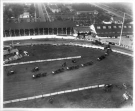
Part of Washington State Fair Collection
Aerial view of full Grandstand, wagon teams parading around interior.
824 results directly related Exclude narrower terms
Part of Washington State Fair Collection
Aerial view of full Grandstand, wagon teams parading around interior.
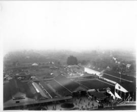
Part of Washington State Fair Collection
Aerial photo of grounds showing midway and barns, Grandstand at far right.
Part of Washington State Fair Collection
Aerial photo of Grandstand full of spectators.
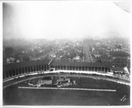
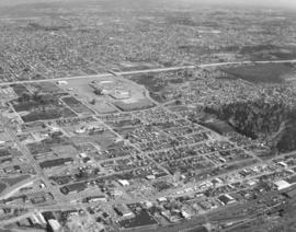
Part of Chapin Bowen Photographs
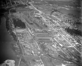
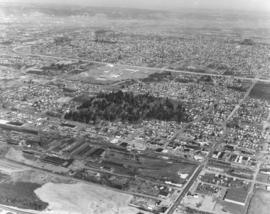
This print from a damaged glass plate negative shows an aerial view of South Tacoma taken in February of 1927. The massive South Tacoma Shops, owned by the Northern Pacific Railway, are located in the center. The plant repaired all Northern Pacific railroad locomotives and cars west of the Mississippi. The shops were composed of 36 separate brick buildings spread out over 15 acres. The grounds were over 1 1/2 miles long, and the work force of 1,250 employees from 20 expert crafts commanded a payroll of $1,500,000 per year. Established in 1890 as Edison Car Shops, the shops closed in 1974. The body of water in the foreground just west of the "shops" was a wetlands area affectionately known to residents of the area as the "South Tacoma Swamp." The road at the right, near the south end of the swamp, is 56th Street. (TNT 02/18/1927, pg. 2)
Part of Chapin Bowen Photographs
Aerial view taken in February of 1926 of the Northern Pacific shops in South Tacoma. Known as the "South Tacoma Shops," the plant was composed of 36 separate brick buildings, covering 15 acres. Craftsmen from 20 expert fields were employed to build, rebuild and service anything that travelled on wheels for Northern Pacific west of the Mississippi. The plant operated from 1890 until its closure in 1974. The body of water to the left was a wetlands area commonly called the "South Tacoma Swamp." It has since been filled in. (TNT 2/18/1927, pg. 2)
Part of Chapin Bowen Photographs
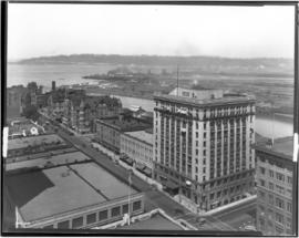
ca. 1928. A Street at So. 11th St., looking north, in 1928. The Tacoma Building, at right center, was completed in 1911. The building was home to the Weyerhaeuser Timber Co. and the Tacoma Commercial Club. It is currently being restored. The Tacoma Hotel can be seen in the background, located where the Frank Russell Co. building stands today.
Part of Chapin Bowen Photographs
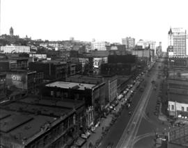
ca. 1928. Elevated view of 1300 block of Pacific Avenue circa 1928. Among the many businesses on Pacific Avenue were the Owl Cafe at 1336 Pacific (lower left) and the Dillion Bldg at 1330-32 Pacific. The familiar spire of the Puget Sound National Bank is to the far right. The Pierce County Courthouse looms in the distance at far left back with the big white walled Greenwich Coliseum (407 So. 13th St.) below. The Greenwich Coliseum had opened in 1927 and would become a premier athletic venue and ballroom.
Part of Chapin Bowen Photographs
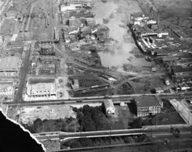
ca. 1929. Head of Commencement Bay while Sullivan Service at 101 Puyallup Ave. (lower left) was under construction. This aerial view was taken circa 1929. Visible landmarks and streets included: the Union Station at upper left corner; Albers Bros. Milling Co. at upper center (large darker building) ; Northwest Woodenware Co. at center along waterway; Wheeler-Osgood Co.'s saw mill at right center. The Sullivan Service was being built at this time facing Puyallup Ave. at left. Puyallup Ave., which runs horizontally left to right, also had the Independent Paper Stock Co. kitty-corner from Sullivan's at 132 Puyallup Ave. The Washington Gas & Electric Co. was also on the same side of Puyallup Ave. as the Independent Paper Stock Co., at 212-216, and was the large building near right. The street at lower bottom running left to right is South 25th St. E. (photograph torn at left corner)
Part of Chapin Bowen Photographs
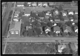
ca. 1935. This is an aerial view of South 43rd and "L" Sts. circa 1935. South "L" runs horizontally in front of the Engine House No. 8 (4301 South "L"). The fire station was built in 1909, replacing the original which had moved to 4102 South "M." Neighboring lots appear small with many trees. BU-2125
Part of Chapin Bowen Photographs
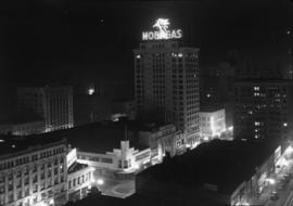
ca. 1941. Circa 1941 aerial view of the business district of Tacoma at night clearly showing the buildings on Pacific Ave. between 9th and 11th on the east side of the street. Buildings shown include: the Anderson building (1001-05 Pacific), the Bank of California (1011-1013 Pacific), and the Washington Building (1019 Pacific). There is a large neon sign for Mobil Gas on top of the Washington Building.
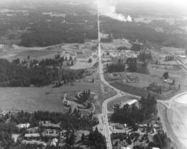
Part of Richards Studio Photographs
Series of aerials around the vicinity of South 19th & Pearl Sts. taken on behalf of Mueller Investment Co. on October 3, 1977. This view is believed to be a bit further north, near the Westgate Shopping Center and the North End water tower and reservoir.
Aerial photographs; Aerial views; Water towers--Tacoma; Reservoirs--Tacoma;
Part of Richards Studio Photographs
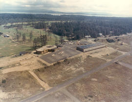
Aerial view of unidentified buildings. Construction may not yet be completed at this unidentified site near a heavily wooded area. There is a large section of cleared land near the two-lane roadways which may later be used for either homes or businesses. Color photograph ordered by Pacific Lanes.
Aerial views; Aerial photographs; Buildings;
Part of Richards Studio Photographs
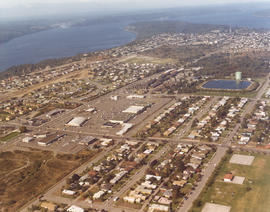
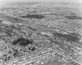
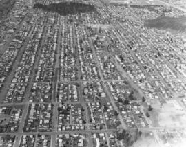
Northeast view from Manitou Park to the Tacoma Mall, taken via helicopter on April 2, 1973. In the near center of the photograph is the sprawling campus of Mount Tahoma High School, built in 1961. The school has since been relocated to a 50-acre site formerly part of the old Flett Dairy. The Tacoma Mall Shopping Center is center, near the top of the photograph, with I-5 traffic flowing adjacent to the busy Mall. Photograph ordered by Puget Sound National Bank.
Aerial view; Neighborhoods--Tacoma--1970-1980; Mount Tahoma High School (Tacoma); Tacoma Mall Shopping Center (Tacoma);
Part of Richards Studio Photographs
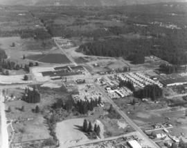
Another in a series of photographs taken on April 3, 1973, on behalf of Collison Realty showing the neighborhoods around 112th & Meridian. There was the Willows Mobile Home Park, Willows Lumber Co., and possibly the new 10-acre Willows Shopping Center under construction in this small business district. This area was still quite rural but would undergo rapid change in the future. The new shopping center, which included such stores as the Piggly-Wiggly, State Farm Insurance and Hallmark's, would serve a population of about 40,000 in the South Hill area, the fastest growing residential community in Pierce County. (TNT 3-18-73, D-10 -article on shopping center)
Aerial views; Neighborhoods--Puyallup--1970-1980;
Part of Richards Studio Photographs
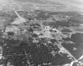
This is the area of 112th & Meridian as seen by air on April 3, 1973. At that time the great stands of evergreens occupied most of the land. The Willows Mobile Home Park and the Willows Lumber Co. are located in the center of the aerial. Much of this area has since been developed. Photograph ordered by Collison Realty.
Aerial views; Neighborhoods--Puyallup--1970-1980;
Part of Richards Studio Photographs
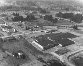
These buildings at the intersection of 112th & Meridian appears to be under construction in April of 1973. This may be the location of the new "Willows" 10-acre shopping center which would open in May. Piggly-Wiggly supermarket and 15 other stores including a Hallmark, State Farm Insurance, and Sunrise Brokers would be the first stores to open; Pay N Save, Puget Sound National Bank, and others would follow in August or September. Aerial photograph ordered by Collison Realty. (TNT 3-18-73, D-10-article on shopping center)
Aerial views; Neighborhoods--Puyallup--1970-1980; Building construction--Puyallup--1970-1980;
Part of Richards Studio Photographs
This is what the populous south side of Tacoma looked like in April of 1973. The aerial photograph of the South 72nd and South Lawrence Sts. looking north was taken on behalf of Puget Sound National Bank. The Tacoma Mall Shopping Center is at the extreme top -right side- of the photograph.
Aerial views; Neighborhoods--Tacoma--1970-1980;
Part of Richards Studio Photographs
One of a series of aerial views, taken aboard a helicopter on April 2, 1973, of the Tacoma Mall area as requested by Puget Sound National Bank. This view is east from South 56th & Manitou area. The Tacoma Mall is upper center with I-5 running next to the shopping center. Heavily wooded area in direct center is part of South Park and also the Tacoma Cemetery, established in 1875. Northern Pacific Shops are lower center.
Aerial views; Neighborhoods--Tacoma--1970-1980; Tacoma Mall Shopping Center (Tacoma);
Part of Richards Studio Photographs
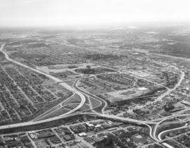
Aerial view on April 2, 1973, of the Nalley Valley and 38th St. interchange. Atlas Foundry is on the right side. The Tacoma Mall is left-center, adjacent to the freeway. There were a variety of ways to get to the Mall, including the heavily utilized South Pine and South 38th St. entrances. Less than nine years old and already boasting of several large department stores as well as specialty shops, the Mall was able to draw a shopping population from as far south as Olympia and from as far north as Seattle. Photograph ordered by Puget Sound National Bank.
Aerial views; Neighborhoods--Tacoma--1970-1980; Tacoma Mall Shopping Center (Tacoma); Shopping centers--Tacoma--1970-1980; Express highways--Tacoma--1970-1980;
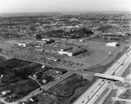
Part of Richards Studio Photographs
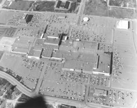
Another in a series of aerial photographs taken on April 2, 1973, for Puget Sound National Bank regarding the Tacoma Mall and surrounding areas. The hundreds of automobiles in the parking lot appear the size of matchbox cars when viewed via helicopter on this sunny spring day. Parking was obviously no problem and the weather would not be a factor either, since the Tacoma Mall was an enclosed, climate-controlled shopping center. J.C. Penney, the Bon Marche, Nordstrom and the soon-to-be constructed Rhodes department store on the west side would be the four major stores anchoring the Mall. Separate buildings in the Mall area included (l-r)the Tacoma Mall Office Building, the Bon Marche Tire Center, the round Pacific National Bank of Washington and the Tacoma Mall Theatre.
Aerial views; Parking lots--Tacoma--1970-1980; Tacoma Mall Shopping Center (Tacoma); Shopping centers--Tacoma--1970-1980; Tacoma Mall Office Building (Tacoma); Tacoma Mall Theater (Tacoma); Pacific National Bank of Washington (Tacoma);
Part of Richards Studio Photographs
ca. 1973. 1973 Richards stock footage. Aerial photograph, probably taken in the fall of 1973, of the St. Regis Paper Co. The plant, the county's largest non-military employer, was located between the Puyallup and St. Paul Waterways. St. Regis would be acquired by Champion International Corp. in 1984 and subsequently sold to Simpson Tacoma Kraft the following year. Simpson Tacoma Kraft still maintains the plant in 2007.
Aerial views; St. Regis Paper Co. (Tacoma)--1970-1980; Puyallup Waterway (Tacoma); St. Paul Waterway (Tacoma);
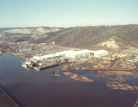
Part of Richards Studio Photographs
ca. 1973. 1973 Richards stock footage. A look by air at the shipyard believed to be Tacoma Boatbuilding, located at 1840 Marine View Dr. N.E., overlooking the Hylebos Waterway. Built on a spacious 20-acre site in 1969, the shipyard was able to expand production of extra-large fishing boats as well as complete government contracts. Tacoma Boatbuilding had decided to move operations to this Hylebos Waterway location after fire had destroyed their plant on the Sitcum Waterway in 1968.
Aerial views; Boat & ship industry--Tacoma--1970-1980; Tacoma Boat Building Co., Inc. (Tacoma); Logs; Hylebos Waterway (Tacoma);
Part of Richards Studio Photographs
Aerial view of Tacoma's largest shopping center, the Tacoma Mall, on April 2, 1973. Traffic on I-5 flows quickly along and there was easy access to the shopping center. South 48th St. with its overpass over I-5 intersects with South Ferry at the Mall. The Allstate Insurance Co.district office is the large building at the southwest corner of South 48th & Ferry. The wooded area next to Allstate would later be developed. This view, looking north, shows the Mall in its entirety, including the separate structures of the Tacoma Mall Theatre, Pacific National Bank of Washington, and the Tacoma Mall Office Building. With 83 acres of land, there was plenty of room for free parking and also for later expansion. Rhodes department store had already announced plans to open a branch at the Mall; it would be built on the extreme far west section. This aerial also shows the Mall's surrounding neighborhoods including Lincoln Heights off 38th St. past the grove of evergreens. Photograph ordered by Puget Sound National Bankl.
Aerial views; Tacoma Mall Shopping Center (Tacoma); Shopping centers--Tacoma--1970-1980; Express highways--Tacoma--1970-1980; Allstate Insurance Co. (Tacoma); Tacoma Mall Theater (Tacoma); Tacoma Mall Office Building (Tacoma);
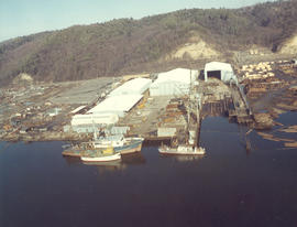
Part of Richards Studio Photographs
ca. 1973. 1973 Richards stock footage. Closer aerial look at shipyard on the Hylebos Waterway, believed to be Tacoma Boatbuilding who had constructed a $3,000,000 plant there after the disastrous fire of 1968 which had destroyed their Sitcum Waterway facility. The Hylebos location now provided 20 acres of space and held separate buildings for aluminum fabricating, steel fabricating, administrative and engineering, and warehouse for equipment. Several boats are pictured above docked at the 300-foot pier. TPL-6583
Aerial views; Boat & ship industry--Tacoma--1970-1980; Tacoma Boat Building Co., Inc. (Tacoma); Hylebos Waterway (Tacoma); Logs; Piers & wharves--Tacoma--1970-1980;
Part of Richards Studio Photographs
One of a series of photographs taken on behalf of Collison Realty by the Richards Studio on April 3, 1973. These aerial views focused on the 112th & Meridian neighborhood. Eventually, the South Hill Mall would be built in this area.
Aerial views; Neighborhoods--Puyallup--1970-1980;
Part of Richards Studio Photographs
The focus of this April, 1973, aerial is the Tacoma Mall Shopping Center and its environs. Located in the city's south end, the Tacoma Mall enjoyed easy access from the freeway and acres of free parking space. Customers could choose from about 100 stores, all under one climate-controlled roof. Rhodes Bros. would be the next large department store to open in the newly expanded Mall, a move that would eventually mean the closing of its flagship downtown location in late 1974. This view, looking east, also shows South Tacoma Way at the bottom. Photograph ordered by Puget Sound National Bank.
Aerial views; Neighborhoods--Tacoma--1970-1980; Tacoma Mall Shopping Center (Tacoma); Shopping centers--Tacoma--1970-1980; Express highways--Tacoma--1970-1980;
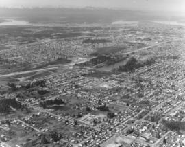
Part of Richards Studio Photographs
Northwest view from South 84th & Park Ave. This aerial look at Tacoma's south side was taken on behalf of Puget Sound National Bank on April 2, 1973. Lake in the center is Wapato Lake, bordered by South Alaska, South 72nd and Sheridan Ave. John S. Baker Junior High (now Middle School) is near bottom-center. Park Ave. has been marked in ink. Yakima Ave. is parallel to Park and is left of Park.
Aerial views; Neighborhoods--Tacoma--1970-1980; Wapato Lake (Tacoma); Baker Junior High School (Tacoma);
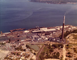
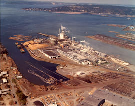
Part of Richards Studio Photographs
ca. 1973. 1973 Richards stock footage. An overhead view of the American Smelting & Refining Co. (ASARCO) and Commencement Bay in 1973. Wispy puffs of smoke emerge from the plant's 562-foot smokestack. ASARCO would eventually close twelve years later due to economic and environmental reasons. The smelter stack was demolished in 1993.
Aerial views; American Smelting & Refining Co. (Tacoma); Smelters--Tacoma--1970-1980; Smokestacks--Tacoma; Industrial facilities--Tacoma; Commencement Bay (Wash.);
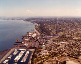
Part of Richards Studio Photographs
ca. 1973. 1973 Richards stock footage. Aerial view of North 52nd St. area, featuring the American Smelting & Refining Co. (ASARCO) plant and smokestack. Also in the photograph is winding Bayshore Drive near Commencement Bay. The tip of Mount Rainier can barely be seen in the background haze.
Aerial views; American Smelting & Refining Co. (Tacoma); Smokestacks--Tacoma; Commencement Bay (Wash.); Rainier, Mount (Wash.);
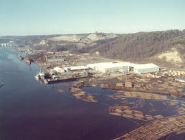
Part of Richards Studio Photographs
1973 Richards stock footage. Aerial view of shipyard believed to be Tacoma Boatbuilding Co. taken on a clear February day in 1973. Masses of logs float nearby until needed. The shipyard faces the Hylebos Waterway and was moved there after Tacoma Boatbuilding's longtime plant on the Sitcum Waterway was destroyed by fire in 1968.
Aerial views; Boat & ship industry--Tacoma--1970-1980; Tacoma Boat Building Co., Inc. (Tacoma); Logs; Hylebos Waterway (Tacoma);