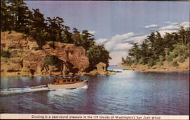
This island group extends from the Canadian boundary on the west and north, from the boundaries of Whatcom and Skagit counties on the east, and to the center of the Strait of Juan de Fuca on the south. There are twenty-five major islands and many smaller islands and reefs of which 172 are habitable. The original name of the archipelago was for Lopez de Haro, who discovered the group in 1789. On June 24, 1791, the birth date of San Juan Bautista, Lieut. Eliza re-named the group using the name of that saint. His name has become official. In 1841, the name Navy Archipelago, was given by the Wilkes Expedition, but it never came into common use. circa 1950.
Printed on front: Cruising is a year-round pleasure in the 177 islands of Washington State's San Juan group
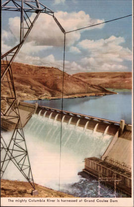
Preliminary plans for the Grand Coulee Dam were made in the early 1920's, but the dam itself was not completed until 1941. The powerhouses and pumping plants were worked on during World War II and completed by 1946. 12 million cubic yards of concrete were used in the project, making it the largest concrete structure in the world. circa 1950.
Printed on front: The mighty Columbia River is harnessed at Grand Coulee Dam.
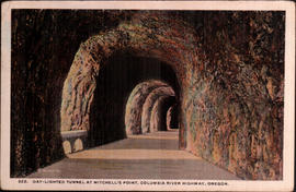
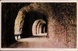
The Mitchell's Point Tunnel was blasted through solid rock 95 feet above the Columbia River. Its five windows, carved through basaltic rock, afforded a scenic view of the Columbia River Gorge. The Mitchell's Point Tunnel was a prominent feature of the Columbia River Highway, now known as the Historic Columbia River Highway. This famous roadway stretched 125 miles along the Oregon side of the Columbia River between Portland and The Dalles. The road is recognized as an engineering marvel and as America's first scenic highway. By the 1930s, the tunnel was considered inadequate for modern traffic. A wider, river-level route (now designated U.S. Route 30) was built at the base of Mitchell Point around 1937. The five famous windows were bricked up, the tunnel filled with rock, and the viaducts leading to the tunnel were blocked. The once-celebrated tunnel remained abandoned, but intact, until 1966 when the Mitchell Point Tunnel was destroyed during the widening of Interstate 84. circa 1918.
Printed on front: Day-lighted Tunnel at Mitchell's Point, Columbia River Highway, Oregon
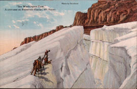
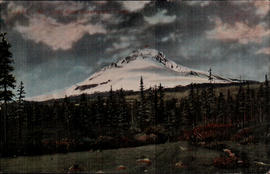
Printed on back: See Washington First. A Crevasses on Roosevelt Glacier, Mt. Baker. Mt. Baker is in Whatcom County, Washington, about thirty-five miles southeast of Sumas. It is 10, 827 feet high.
Message: 3:30 PM Within 3 miles of the line. Ralph
Message: Visted American Lake yesterday. Saw Soldiers then stopped at Tacoma for couple hours thense to Seattle and on to Silver Lake. Wenatchee about Wednesday evening. Ralph
Addressee: Daisy C. Philbrick Hoquiam, Wash. 610-6
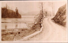
Printed on back: This view gives one a clear idea of the wonderful engineering used in the construction of this famous highway. The road is cut through solid granite.
Message: Dear Dora Your letter was rec. this morn. Hope the family are much better. May is getting better but is far from being well. I am all tired out myself, to. Tell Bessie I send my best regards to them all. Anna.
Addressee: Miss Dora Hansen Newberg, Oregon c/o Chas Wade Rout
Mount Baker is an active volcano in the Cascade Range of Washington State, named after Joseph Baker of the H.M.S. Discovery, who first saw and recorded the peak in 1792. The first successful ascent of the mountain took place in August, 1868. It is located about 30 miles east of Bellingham in Whatcom county, in the Mount Baker National Forest. It has the most glaciers of any mountain in the Cascade range except for Mount Rainier. circa 1917.
Printed on front: See Washington First. A Crevasse on Roosevelt Glacier, Mt. Baker.
Government Camp is an unincorporated community located in Clackamas County, Oregon, south of Mount Hood. Government Camp was given its name by settlers traveling the Barlow Road, who discovered several wagons abandoned there by the Regiment of Mounted Riflemen. circa 1920.
McMurray is a scattered community of small farms and homes on the west shore of Lake McMurray southeast of Mount Vernon in southwest Skagit County. It was once an important lumber and shingle manufacturing town. The railroad station was named by the Northern Pacific Railway for Dr. McMurray, a physician who homesteaded the site of the town. It was incorporated February 1, 1910 and disincorporated October 31, 1922. circa 1917.
The Mitchell's Point Tunnel was blasted through solid rock 95 feet above the Columbia River. Its five windows, carved through basaltic rock, afforded a scenic view of the Columbia River Gorge. The Mitchell's Point Tunnel was a prominent feature of the Columbia River Highway, now known as the Historic Columbia River Highway. This famous roadway stretched 125 miles along the Oregon side of the Columbia River between Portland and The Dalles. The road is recognized as an engineering marvel and as America's first scenic highway. By the 1930s, the tunnel was considered inadequate for modern traffic. A wider, river-level route (now designated U.S. Route 30) was built at the base of Mitchell Point around 1937. The five famous windows were bricked up, the tunnel filled with rock, and the viaducts leading to the tunnel were blocked. The once-celebrated tunnel remained abandoned, but intact, until 1966 when the Mitchell Point Tunnel was destroyed during the widening of Interstate 84. circa 1916.
Printed on front: Daylighted tunnel at Mitchell's Point, Columbia River Highway, Oregon
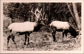
Elk cows average 500 lbs., stand 4’ feet at the shoulder, and are 6’ feet from nose to tail. Bulls are some 25% larger than cows at maturity, weighing an average of 700 lbs., standing 5 feet at the shoulder and averaging 8 feet in length. The largest of the subspecies is the Roosevelt elk, found west of the Cascade Range in the U.S. states of California, Oregon and Washington, and in the Canadian province of British Columbia. circa 1940.
Printed on front: Bull Elk-Olympic Peninsula, Wash.
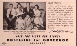
Albert Dean Rosellini, born January 21, 1910, is a lawyer from the state of Washington. Rosellini is a member of the Democratic Party and served in the Washington Legislature before his two terms as Governor (1957-1965). This was a campaign card from his first run for Governor. circa 1956.
Printed on front: Dear Friend: Here are five good reasons why I have always been a leader in the fight against organized vice and juvenile delinquency in the state. As your governor, I will use the experience and knowledge I have acquired as Chairman of the Crime Investigating Committee and as a youth guidance leader to protect our children. Albert D. Rosellini Senator Albert D.Rosellini, his charming Scandinavian wife, Ethel, and their five children Join the fight for right! Rosellini for Governor Democrat
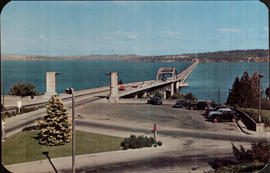
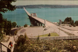
The original two-way, four-lane toll bridge was designed by the engineer Homer Hadley and constructed of reinforced concrete in 1940. It sank in a storm on November 25, 1990, while it was undergoing refurbishing & repair. The current bridge was built in 1993. circa 1950.
Printed on back: Lake Washington Floating Bridge-World's longest bridge constructed of concrete pontoons is an engineering marvel. Constructed and financed by tolls, it is now free and carries U. S. Highway No.10 directly east from downtown Seattle and on through Snoqualmie pass to the east.
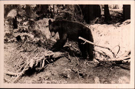
In Washington, black bears live in a diverse array of forested habitats, from coastal rainforests to the dry woodlands of the Cascades’ eastern slopes. In general, black bears are strongly associated with forest cover, but they do occasionally use relatively open country, such as clearcuts and the fringes of other open habitat. Black bears can take up residence in small dens, some scarcely bigger than a garbage can. Den sites include tree cavities, hollow logs, small caves, and areas beneath large roots, stumps, logs, and rural buildings. They’ll occasionally excavate a den in the side of a hill near shrubs or other cover. circa 1940.
Message: Dear Sis: Rec'd your letter today. Wish you can ? this good weather we are having. I saw Dr. today and he says you had better stay awhile and enjoy yourself ?. Miss S. phoned again today. She is very ? for you come ? back and ? know night away. Howard says hello. Jessie is ? Kidney trouble, Dr. says. ? Love ?
Addressee: Miss Dora Hansen, Hermingston, Ore.Box 351 c/o L. C. White
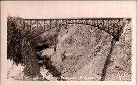
Designed by Conde B. McCullough, this bridge is 464-feet long and consists of a 330-foot two-hinged steel braced-spandrel deck arch. The structure was one of the highest bridges in the United States, at 295-feet from deck to streambed, when it was built. It was completed in 1926. circa 1945.
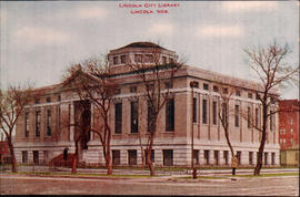
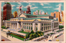
This landmark building, a white marble Beaux-Arts revival, designed by John Merven Carr’re and Thomas Hastings, was completed in 1911 after 12 years of construction. At the time, it was the largest marble structure in the United States. A large restoration project of the exterior, in honor of the 100 year anniversary in 2011, is currently underway. The library is now formally known as the Humanities and Social Sciences Library. circa 1930.
The original two-way, four-lane toll bridge was designed by the engineer Homer Hadley and constructed of reinforced concrete in 1940. It sank in a storm on November 25, 1990, while it was undergoing refurbishing & repair. The current bridge was built in 1993. circa 1950.