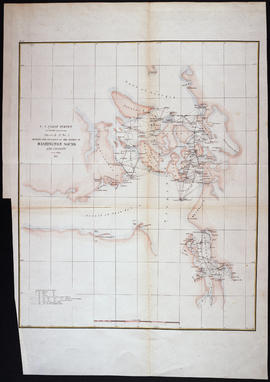
United States. Coast and Geodetic Survey. Bache, A. D. (Alexander Dalles). 1 map; 41 x 34 cm. Scale 1:400,000 At head of title: U.S. Coast Survey, A. D. Bache Superintendent.
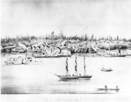
ca. 1858. Copy of customer print, ordered by the City of Steilacoom. Unknown artist's rendering of Steilacoom's waterfront in 1858, while Washington was still a territory. Steilacoom became the first seat of government in Pierce County. Picture is from the collection of Mrs. Clyde V. Davidson, Steilacoom resident. The vessel, Enterprise, steams along the quiet waters of Steilacoom, sharing space with various sailboats, canoes and two and three-mast schooners. The Enterprise traded between Olympia and Steilacoom. Copy of print ordered on January 25, 1963. (TNT 5-8-62, D-20; photograph also used by E.T. Short of the T. Times 2/21/1939, pg. 3)
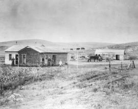
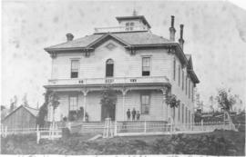
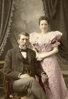
ca. 1860s. Undated photograph, possibly taken in the 1860s, of an 19th century family posed in front of their home. The photograph is taken at a wide angle so that the family's possessions, including planted crops, horses grazing, wagon and carriage, hitched span of horses, barn and extended home are prominent. The home appears to have been added on; the original sod house has a framed addition. The people themselves are not shown in close-up. The location of the property is not identified. Photograph believed to have been ordered by Mrs. G.R. Utterback on January 24, 1970.
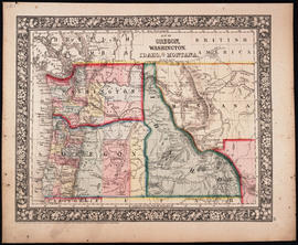
Philadelphia : S. A. Mitchell, Jr. 1 map : hand col. ; 27 x 34 cm. Relief shown by hachures. Shows counties, cities, railroads, routes of wagon trails, and rivers. Scale ca. 1:4,435,000. Lower right: 50. Decorative border. Dated 1860 in bottom margin, but some question whether that might be the date of the original copyright of the base map.
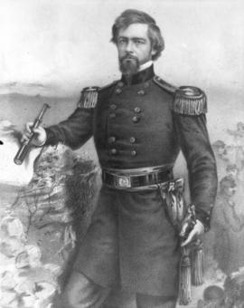
ca. 1862. Portrait of Brigadier General Isaac Ingalls Stevens, first governor of Washington Territory. Copy made for Tacoma Times by Richards Studio, March 7, 1938, also used in Washington Golden Jubilee edition, July 19, 1939. Stevens served as governor from 1853-1857. A Democrat, he was appointed by President Franklin Pierce. In addition, he served as Superintendent of Indian Affairs. This portrait depicts Stevens as a Brigadier General of Volunteers and may have been made ca. 1862. He was killed in action in 1862 during the Second Battle of Bull Run (Second Manassas). ALBUM 10.
Governors; Stevens, Isaac Ingalls, 1818-1862; Generals; Portraits;
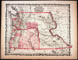
New York: Johnson and Ward 1 map : hand col. ; 32 x 40 cm. Relief shown by hachures. Shows counties, cities, locations of native American tribal groups, and proposed railroad. Scale ca. 1:3,500,000 On verso: portion of "Historical and Statistical View of the United States, 1860", tables for Vermont, Virginia and Washington. In lower right margin: 57. Decorative border. Oregon counties Jackson and Josephine have been interchanged.
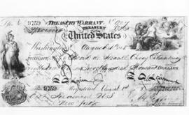
ca. 1868. Copy for Tacoma Times columnist E.T. Short of Treasury warrant for purchase of Alaska, dated 08/01/1868. Check for $7,200,000 to Emperor of Russia. Warrant & acknowledgement. (T. Times)
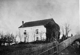
ca. 1870. On October 9, 1963, the Pierce County Pioneer & Historical Association dedicated a marker on the site of the old Steilacoom jail. The marker was made of imported red Swedish granite on which was carved a view of the (pictured) two-story jailhouse. The jail was built in 1858 by George W. Manville, Spanaway architect and contractor. It was the first brick jail north of the Columbia, the first Pierce County jail, and the first jail in the Washington Territory. It was located at 1800 Starling Street, between Balch & Main. Moses Spicer, elected in 1859, was the first jailer. It served as a jail until 1881 and then was used to store government records. In 1910 Dr. S.M. LaCrone and his wife purchased the old jail; the LaCrones lived on the top floor. The jail was demolished in 1944. (TNT 10-6-63, A-1)
ca. 1870. Beginnings of Tacoma City circa 1870. Photo taken by Anthony Carr, who was Old Tacoma's first photographer. Cabin nearest the two trees on the left is Job Carr's cabin and his farm is in the foreground. The Steele Hotel, Tacoma's first hotel, is the "large" L-shaped building at left of center. (Photo donated by Ron Karabaich) (Caroline Gallacci & Tacoma Historical Society: Old Tacoma, p. 11)
Steele Hotel (Tacoma); Hotels--Tacoma--1870-1880; Carr, Job--Homes & haunts;
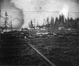
ca. 1873. "Tacoma, the terminus of the Northern Pacific Rail Road, Washington Territory" image on early stereopticon slide taken by Oliver Dennie of Portland, Oregon (slide from the collection of Dan Kerlee, Seattle, Washington). This photograph, and also KERLEE - 02, shows the area on top of the bluff in "New Tacoma" around what is now South 7th & Pacific Avenue. The unidentified man in the foreground is leaning against a tree stump close to where the Northern Pacific Railroad headquarters building would be constructed in 1887. Once the Board of Directors of the Northern Pacific Railroad formally approved locating the terminus, hundreds began swarming to the area. Tents were set up on vacant lots for which $1 per front foot was paid per month and houses quickly sprang up for waiting occupants. Financial woes would shortly grip the nation, subsequently slowing down the rush of people to Tacoma. (Prosch: McCarver and Tacoma, p. 179-80-article)
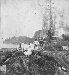
ca. 1873. "Water front and wharf at Tacoma, W.T." Early stereopticon slide by Oliver Dennie, Portland, Oregon. Pioneering men and women pose by the waterfront next to a downed tree circa 1873. The town was becoming civilized with picket fences, two-storied buildings and even washing hung on a line. In the background at left is the Hanson, Ackerson & Co. lumber mill, store and wharf. The Steele Hotel, Tacoma's first hotel, is the large two-story building at right. (From the collection of Dan Kerlee, Seattle, Washington). (Prosch: McCarver and Tacoma, p. 181)
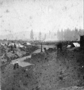
ca. 1873. "Old Town of Tacoma, W.T." Early stereopticon slide by Oliver Dennie, Portland, Oregon (From the collection of Dan Kerlee, Seattle, Washington). The building with darker roof in the distance at center-left is believed to be the Steele Hotel at 2105 No. 30th St. It was built in 1868 and was the first frame building and first hotel built in Tacoma. Also on the left near the foreground is a sign indicating "carpenter shop," possibly referring to the Ball & Bonney carpenter shop which opened between 1870 and 1872. On the right side of the photograph in the distance are reportedly a saloon and a dance hall. (dark roof, light exterior). This photograph was taken circa 1873 at the foot of the present No. 30th St. looking south. It was then called Second Street. (Prosch: McCarver and Tacoma, p. 179)
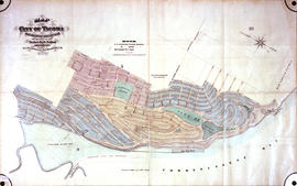
ca. 1873. Frederick Law Olmsted plat map for City of Tacoma (New Tacoma), Washington Territory. Created for the Northern Pacific Railroad, and the Tacoma Land Company
Maps; Olmsted, Frederick Law, 1822-1903; Tacoma Land Co. (Tacoma); Northern Pacific Railway Co. (Tacoma);
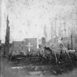
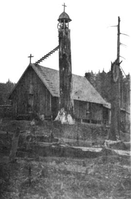
ca. 1873. St. Peter's Episcopal Church, Old Tacoma. Small Carpenter Gothic church, built 1873, with a tall cedar stump covered with ivy for a bell tower. Copy of early photograph for Mr. Short of the Tacoma Times. Two weeks after the Right Reverend B.W. Morris, Episcopal Bishop of Washington and Oregon, rode into Tacoma in the bed of a wagon used for hauling earth on the North Pacific grade, St. Peters Church was built. It was the first church in Tacoma. This photograph was reproduced by Turner Richards from a faded photo made by Joseph Buchtel of Portland after the bell tower on the top of the 40 foot fir stump was completed. The photograph was loaned to the Times by Mrs. Alice Rector Watson. (T.Times 9/27/1935, pg. 16)
Episcopal churches--Tacoma; St. Peter's Episcopal Church (Tacoma);
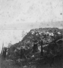
ca. 1873. "Terminus of Tacoma, looking toward Mt. Rainier, W.T." Early stereopticon slide by Oliver Dennie, Portland, Oregon (From the collection of Dan Kerlee, Seattle, Washington). One or two wooden shacks and a handful of tents occupy the top of the bluff near what is now South 7th & Pacific Avenue. This view is the beginning of New Tacoma as pictured in the fall of 1873. Commencement Bay at left. (Prosch: McCarver and Tacoma, p. 185)
Cities & towns--Tacoma; Commencement Bay (Wash.); Tree stumps--Tacoma; Houses--Tacoma--1870-1880;
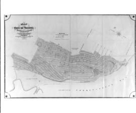
ca. 1873. Frederick Law Olmsted plat map for City of Tacoma (New Tacoma), Washington Territory. Created for the Northern Pacific Railroad, and the Tacoma Land Company
Maps; Olmsted, Frederick Law, 1822-1903; Tacoma Land Co. (Tacoma); Northern Pacific Railway Co. (Tacoma);
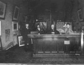
ca. 1880. Copy of a photograph of the interior of the Canadian Pacific Railroad office, circa 1880s. Signs for Standard Life and Accident Insurance Company on counter, four men behind. Pictures of ships and posters for Cunard and Beaver Lines on walls. Copy for Mr. Short, Tacoma Times. (Argentum)
Canadian Pacific Railway (Tacoma); Railroad companies--1880-1890; Railroads; Railroad facilities;
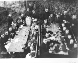
ca. 1880. Copy of customer's damaged print. Date of original picture is unknown; it could possibly have been taken in the 1880s. Two groups of boys and girls are photographed sitting outside at separate tables. The boys appear to be in the process of making brooms while the girls are doing handiwork. There is a possibility that these children were in some type of custodial living arrangements in a foreign country. Two of the older boys are wearing sweaters with a crown and cross design, possibly signifying they were part of a religious school or home. Photograph commissioned by Peter Anderson on October 22, 1954.
Group portraits; Children; Brooms & brushes; Handicraft;
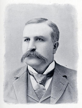
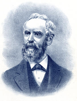
ca. 1880. Henry Drum was elected mayor of Tacoma on May 1, 1888. Mayor Drum, a prominent banker and staunch Democrat, defeated A.C. Smith by a majority of 52 votes out of a total of 1,712. Mr. Drum had arrived in New Tacoma only five years before his mayoral election and had immediately immersed himself in the business and social functions of this growing city. He was a stockholder and director in many businesses including the Skagit Railway & Lumber Co., Fidelity Trust Co., and Tacoma Lumber & Manufacturing Co. as well as one of the organizers of the First Unitarian Society in Tacoma and was an active Mason. Mr. Drum served one term as mayor, choosing not to run for re-election. He became the only Democrat elected to the first state Senate and served several terms. This picture is from William F. Prosser's "A History of the Puget Sound Country" The Lewis Publishing Company, 1903. opp p.96 (North Pacific History Co.: History of the Pacific Northwest, p. 307-309) ALBUM 16. Also G1.1-055
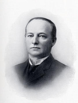
ca. 1880. Herbert S. Huson was elected mayor of Tacoma April 5, 1892. Mr. Huson defeated his Democratic opponent Alexander Parker by a 155-vote margin. According to historian Herbert Hunt, the campaign was highly heated with Alexander Parker being accused of favoring the Chinese in 1885. Many bets of money and goods were made as to the outcome of the election, including an unusual reckoning whereby a man who had backed the losing candidate was pelted with rotton eggs for a full 15 minutes. The newly elected mayor, Herbert S. Huson, was a graduate of Grinnell College and a native of Wisconsin. He came to Washington in 1883 as an assistant engineer for the Northern Pacific Railroad and built a switchback across the Cascades. He would later help to organize the Citizens' National Bank. The pioneer railroad builder would pass away in October of 1927 at Cornelius, Oregon. This picture is from "History of Washington, Vol. 2" , edited by Julian Hawthorne, American Historical Publishing Co., 1893. p.157 ALBUM 16. (History of Washington, Vol. 2, p. 559-560; Obit., T.Times 10-10-27)
ca. 1880. Henry Drum was elected mayor of Tacoma on May 1, 1888. Mayor Drum, a prominent banker and staunch Democrat, defeated A.C. Smith by a majority of 52 votes out of a total of 1,712. Mr. Drum had arrived in New Tacoma only five years before his mayoral election and had immediately immersed himself in the business and social functions of this growing city. He was a stockholder and director in many businesses including the Skagit Railway & Lumber Co., Fidelity Trust Co., and Tacoma Lumber & Manufacturing Co. as well as one of the organizers of the First Unitarian Society in Tacoma and was an active Mason. Mr. Drum served one term as mayor, choosing not to run for re-election. He became the only Democrat elected to the first state Senate and served several terms. This picture is from William F. Prosser's "A History of the Puget Sound Country" The Lewis Publishing Company, 1903. opp p.96 (North Pacific History Co.: History of the Pacific Northwest, p. 307-309) ALBUM 16. Also G1.1-055
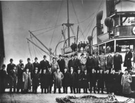
ca. 1880. Copy of photograph of large group of railroad men on dock and on plankway of steamship. All men are wearing coats and hats, most hats are bowlers, derbys. Circa 1880s. Copy made in 1935 for the Tacoma Times. (T. Times)
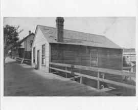
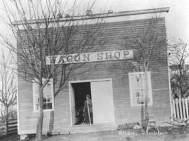
ca. 1880. Nathaniel Orr's Wagon Shop. Nathaniel Orr was a pioneer wagon maker who had journeyed from Virginia in 1850 to eventually make his home and business in Steilacoom. The photograph of the Wagon Shop at 1811 Rainier St. is undated but perhaps taken in the 1880's. The man standing in the doorway is possibly Nathaniel Orr. The building appears to be a bit lopsided as blocks seem to be placed underneath to make it level. Information received from a reader indicates that Orr had built the house with chimney visible on the right of this photograph as a wagon shop in 1853-4 and built/repaired wagons on its bottom floor (accessible from what is now Rainier St.) When Orr wed in 1868, his wife convinced him to build his wagons somewhere other than in her home and thus this large Wagon Shop was constructed. Besides building wagons, he turned his hand to making necessities such as beds, tables, chairs, spinning wheels and even coffins. He also started a commercial orchard in town. Nathaniel Orr died in 1896 at the age of 69; his home and orchard would later be sold to the Steilacoom Historical Museum Assn. and be placed on the State and National Registry. The Wagon Shop operates as a living museum and has kept its original appearance. Photograph ordered by the Town of Steilacoom. (Town on the Sound, p. 32-36)
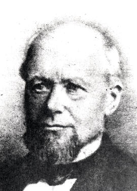
ca. 1880. Alexander Smith (A.S.) Abernethy, elected Mayor of Tacoma September 6, 1882. Mr. Abernethy served as Mayor in 1882 & 1883. He was born in New York in 1813. In 1850, he was asked by his older brother George to come to the Northwest to manage the Oak Point (saw) Mill. George Abernethy (1807-1877) went on to become Oregon's first Governor. Alexander Abernethy was Oak Point's most prominent citizen from 1850-1880, campaigning for Washington Territory and later serving as a Republican in local political positions. He had a land claim west of Longview in Cowlitz County. Already an elderly man when he served as Mayor, he died five years later in February of 1888 and was buried in the family cemetary on his land claim. (History of Stella, Oak Point, Eufaula, Coal Creek and Surrounding Areas; US GenWeb Archives)
Abernethy, Alexander Smith; Mayors--Tacoma--1880-1890;
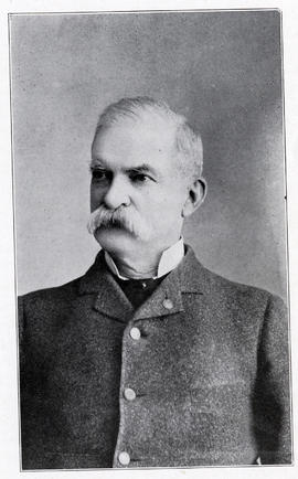
ca. 1880. John W. Sprague, elected mayor of Tacoma December 10, 1883. First mayor of the consolidated city. General Sprague received the Medal of Honor for service during the Civil War. He was the first president of the Tacoma Chamber of Commerce and was instrumental in starting many of the first businesses in early Tacoma. Photo from Herbert Hunt's "Tacoma, Its History and Its Builders, Volume 1" opp p.190 (Olsen: Tacoma Beginnings, p. 56) ALBUM 16. (Additional information received from a reader)
ca. 1880. David S. Lister, Sr. was elected mayor of New Tacoma May 9, 1881. Under a special act of the Legislature, passed November 5, 1881, entitled "An act to confer a City Government upon New Tacoma," the Board of Trustees was merged into the "Common Council," and the President of the Board became the Acting Mayor. Mr. Lister was the owner of an iron foundry located at 17th & Pacific Avenue. This picture is from "History of the Pacific Northwest: Oregon and Washington" compiled and published by the North Pacific History Company, Portland, Oregon, 1889. opp p.600 ALBUM 16