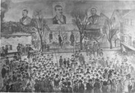
Print preview Close

Showing 68948 results

Collections
Advanced search options
Print preview View:

31445 results with digital objects Show results with digital objects

Byrd Family Papers

  • 6.2.2
  • 1804 - 1934

Includes diaries, legal documents, photographs, and artifacts related to the Byrd family who arrived in the Puget Sound region from Illinois in 1853.

Byrd Family

Map of Oregon, Washington, Idaho, and Part of Montana, 1860

Philadelphia : S. A. Mitchell, Jr.
1 map : hand col. ; 27 x 34 cm. Relief shown by hachures. Shows counties, cities, railroads, routes of wagon trails, and rivers. Scale ca. 1:4,435,000. Lower right: 50. Decorative border. Dated 1860 in bottom margin, but some question whether that might be the date of the original copyright of the base map.

Johnson's Washington and Oregon, 1863

New York: Johnson and Ward
1 map : hand col. ; 32 x 40 cm. Relief shown by hachures. Shows counties, cities, locations of native American tribal groups, and proposed railroad. Scale ca. 1:3,500,000 On verso: portion of "Historical and Statistical View of the United States, 1860", tables for Vermont, Virginia and Washington. In lower right margin: 57. Decorative border. Oregon counties Jackson and Josephine have been interchanged.

J. W. Roberts Papers

  • 6.1.3
  • 1868-1914

Includes correspondence, journals, financial papers, legal papers, printed materials and ephemera, photos and maps. Correspondence consists of both personal and business-related letters (1873-1911). Journal entries provide twenty-two years worth of short accounts of daily farm life, and occasionally mention other early Steilacoom pioneers (1868-1912). Financial papers include tax receipts (1866-1930), handwritten and printed receipts (1861-1931), a checkbook (1861-1862), and small account books recording work, expenses, and brief journal entries (1862-1910). Legal documents include land contracts and descriptions, and court documents relating to the estate of J.W. Roberts (1911-1915). Printed materials and ephemera include a variety of items such as business cards, pamphlets, and menus (undated), and newspaper clippings (1895, 1913-1914). A small series of photos are mostly undated and unidentified. There are also two undated handwritten maps of the Spanaway area.

J. W. Roberts

BOWEN MAYOR-006

ca. 1880. Henry Drum was elected mayor of Tacoma on May 1, 1888. Mayor Drum, a prominent banker and staunch Democrat, defeated A.C. Smith by a majority of 52 votes out of a total of 1,712. Mr. Drum had arrived in New Tacoma only five years before his mayoral election and had immediately immersed himself in the business and social functions of this growing city. He was a stockholder and director in many businesses including the Skagit Railway & Lumber Co., Fidelity Trust Co., and Tacoma Lumber & Manufacturing Co. as well as one of the organizers of the First Unitarian Society in Tacoma and was an active Mason. Mr. Drum served one term as mayor, choosing not to run for re-election. He became the only Democrat elected to the first state Senate and served several terms. This picture is from William F. Prosser's "A History of the Puget Sound Country" The Lewis Publishing Company, 1903. opp p.96 (North Pacific History Co.: History of the Pacific Northwest, p. 307-309) ALBUM 16. Also G1.1-055

"The Fern Hill Story"

Oversized scrapbook that was "undertaken August-October 1953", according to the inside cover, to celebrate the Washington Territorial Centennial. Contains news clippings of the Fern Hill neighborhood including the Fern Hill School, residents traversing the Naches Pass, and citizen recollections of the neighborhood. The "Scrapbook Commitee" of 1953 included Mrs. M.P. Howard (chairman), Mrs. Milfred Hartley, Mrs. Geyer Graham Sr. and Rev. Donald Baldwin. The Committee gave the scrapbook to the Fern Hill Branch of Tacoma Public Library in 1953. News clippings range from c. 1940-c. 1953 with one clipping from the Tacoma News Tribune (11/01/1953) inside the scrapbook cover telling the history of the scrapbook.

Tacoma Daily News

  • 5.2.1
  • 1883 - 1885

Early Tacoma newspaper with local and regional news, editorials, and advertisements.

Tacoma Ministerial Alliance Records

  • 3.7.2
  • 1883-1912

Includes meeting minutes, correspondence, programs, governing documents, and other materials related to the operations of the Tacoma Ministerial Alliance.

Tacoma Ministerial Alliance

Tacoma City Council Resolutions

  • 1.1.1
  • 1884-1985

Includes Tacoma City Council Resolutions and supporting documentation. Resolutions are non-binding statements made by the Tacoma City Council. They are formal expressions of a particular position that are endorsed and signed by the mayor. Though resolutions are not a law, they are a formal declaration of support from the City Council.

Also includes bound resolution duplicates in Box 221-230. Missing resolutions: 15400, 15854-15859, 16489-16490, 17484, 19899, 20590-20618, 22644-22649, 22900-22999, 23450, 24850.
Includes bound duplicate copies

Tacoma City Council

View of the City of Tacoma, W.T., Puget Sound, County Seat of Pierce Cty., Pacific Terminus of the NPRR, 1884

Madison, Wis. : J. J. Stoner; Ithica, N.Y. : Historic Urban Plans
1 map; 31 x 83 cm. Bird's-eye view. Perspective map not drawn to scale. Oriented with North to lower right. Includes key to points of interest. "Reproduced ... from an engraving in the Library of Congress." Includes inset of "Mount Tacoma, 14,444 ft. high." "Beck & Pauli, Litho., Milwaukee, Wis."

Central School

This is the original Central School, built in 1883 for $18,000 and located at 1114 S Altheimer (then S G St), now the area of Bates Technical College. It was modeled after the Euclid Avenue School of Cleveland, Ohio, by architect Joseph Sherwin of Portland. It stood out along the Tacoma skyline with its 90-foot bell tower visible for miles. The school contained twelve rooms and was considered a showplace for the city. Rapid growth made the enrollment climb to 964 by 1886, taught by a staff of 18 teachers. Remodeling and additions to the school occurred before the school moved its 1000 elementary students to a new Central School located at So. 8th & Tacoma Ave. So. in 1913. The new Central School cost $165,000, almost ten times the cost of the original school. The old Central School was demolished in 1914 and served as a hobo shelter for a few months prior to its demolition. (Olsen: For the Record, p. 47-48-various photographs) King 009, TPL 1103.


Back of photo:
Central school, S.W. corner of S.W. and G. St now the Bates Vocational School Tacoma, Wash.

Northern Pacific Railroad track along Commencement Bay, Tacoma, Washington Territory

Northern Pacific Railroad track along Commencement Bay, Tacoma, Washington Territory, circa 1885. Mt. Tacoma (Rainier) and tideflats in background. The railroad tracks were built on fill dirt. The water-filled half-moon section would also be filled in to become the railroad yard, called appropriately the "half-moon yard." KING-008, G76.1-101 (Digital copy only. No print or negative available).

Tacoma Police Department Records

  • 1.3.1
  • 1885 - 1985

Includes scrapbooks, notices, city council documents related to police misconduct, and a departmental manual from 1891. Also included are annual and monthly reports and crime scene reporters notebooks.

Tacoma Police Department

C. E. and Hattie King Photographs

  • 2.1.4
  • 1885

Includes 14 photographs of Tacoma taken c. 1886-1900 by C. E. and Hattie King of Commencement Bay, Northern Pacific railroad tracks, local schools, and members of the Puyallup and other area tribes.

C.E. and Hattie King

Boats at Northern Pacific dock with Blackwell Hotel, Tacoma, Washington Territory, circa 1885

Boats at Northern Pacific dock, Tacoma, Washington Territory, circa 1885. The owners of the warehouse in the center of photograph were not identified. The large building to the far left is the Blackwell Hotel, considered New Tacoma's first hotel. Built by the Northern Pacific Railroad, it opened on January 1, 1874 and closed in 1884. It was razed during the summer of 1901. KING-002, TPL-1095

Members of Puyallup Tribe playing game on shores of Puget Sound

In this photograph believed to be from the mid 1880s, a group of Puyallup Indians gathers on the shore of the Puget Sound to gamble. The game they are playing appears to be the bone game, where two teams of 10-12 sit opposite each other. One team has four bones which they pass to the distracting accompaniment of the pounding of sticks and singing of chants. The other team must guess who has the bones. In the background are longboats and a bridge. The Puyallup village during this time period was believed to be at the foot of South 15th St. KING-003, TPL 2897.

Results 1 to 30 of 68948