Showing 55 results

Collections
Aerial Photography With digital objects 138,000-142,000
Print preview View:

D139204-3

Aerial view of the Port Industrial waterway taken in late August, 1963, with industrial facilities close by. 11th St. runs horizontally over the waterway. Bridge is the Blair Bridge. Photograph ordered by Port of Tacoma. TPL-2248


Aerial photographs; Port Industrial Waterway (Tacoma);

D140600-327

1964 stock footage. Aerials taken on July 24, 1964, looking toward Tacoma from over Sumner. Hylebos Waterway to extreme right. Other notable water features are the City (now Thea Foss) Waterway, meandering Puyallup River, and Port Industrial Waterway. Wooded Point Defiance near top of photograph. Fox Island left corner.


Aerial photographs; Hylebos Waterway (Tacoma); Puyallup River (Wash.);

D140419-1

Aerial photographs of the Lakewood area were taken on December 21, 1963, at the request of Puget Sound National Bank. This is reportedly the area between 84th and Ponders Station. Lakewood neighborhoods to the left would include Villa Plaza Shopping Center and Clover Park High School. The three large lakes are: Steilacoom, Gravelly and American Lake; Tacoma Country & Golf Club is on the shores of American Lake. McChord AFB to the right of I-5. TPL-9304


Aerial photographs; Neighborhoods--Lakewood--1960-1970; American Lake (Wash.); Lake Steilacoom (Wash.); Gravelly Lake (Wash.);

D140600-30

Aerial stock footage, February, 1964, of area near the upcoming Tacoma Mall. King's Hilltop Drive-In, upper right, is on So. 38th St. close to I-5. Eventually the large wooded area would become filled with businesses and parking lots associated with the Mall.


Aerial photographs; Shopping centers--Tacoma--1960-1970;

D142189-8

Aerial photograph requested by Puget Sound National Bank and taken in July, 1964, of the Tacoma tideflats area and Port of Tacoma and surrounding neighborhoods. Looking in a northwesterly direction, Gig Harbor and the Peninsula are at the top. Widely channelized Puyallup River is in the center. I-5 freeway runs from the center to the right side of the photograph.


Aerial photographs; Puyallup River (Wash.); Express highways--Tacoma--1960-1970;

D142432-1

Aerial view of the 2600 block of South Tacoma Way featuring Ben's Truck Parts, Frank Buchanan Sales and Steven Motor Co. on August 7, 1964. Ben's Truck Parts and auto wreckers was owned and operated by Ben Etsekson. It was located at 2622 South Tacoma Way next to Frank Buchanan Sales and across the street from the Plymouth-Chrysler dealership. Road in right corner may be Pine St. Photograph ordered by Ben's Truck Parts.


Aerial photographs; Ben's Truck Parts (Tacoma); Automobile equipment & supplies stores--Tacoma--1960-1970; Frank Buchanan Sales (Tacoma); Steven Motor Co. (Tacoma); Signs (Notices);

D138106-2

Overhead view of Georgia-Pacific Corp. quarters on Ross Way. A few cars are parked outside Georgia-Pacific on April 9, 1963. One large truck appears to be in the process of loading boxes. Georgia-Pacific, dealers in wholesale plywood, had built a plant in the industrial Tideflats area near Thorne Rd. and E. 11th St.


Aerial photographs; Georgia-Pacific Corp. (Tacoma);

D139204-6

Closer view of Tacoma Tideflats area in late August, 1963, focusing on the Port Industrial Waterway and Blair Bridge. The waterway is wide enough for log booms to share space with docked ships and boathouses. At the top of the photograph, a small segment of the Puyallup River can be seen. Next are the Milwaukee and Sitcum Waterways. Photograph ordered by Port of Tacoma. TPL-10519


Aerial photographs; Logs; Port Industrial Waterway (Tacoma); Milwaukee Waterway (Tacoma); Sitcum Waterway (Tacoma);

D139403-1

Aerial view taken on September 18, 1963, of the City of Fircrest and vicinity. Surrounded by trees, Fircrest is pictured toward the center of the photograph. Pearl Street runs through Fircrest all the way to Point Defiance. Orchard Street runs parallel to Pearl to its right. Narrows Bridge is at the top. Ruston with the ASARCO smelter is at top right corner with forested Point Defiance to its left. A similar aerial view, taken on the same day, is at D137300-529. Photograph ordered by Puget Sound National Bank who may have asked that white dots be drawn on the photograph defining the approximate Fircrest boundaries. Puget Sound National Bank would open a new branch building in Fircrest two years later on November 6, 1965, at the Fircrest Village Square Shopping Center. Fircrest at the time had a population of 4,588.


Aerial photographs; Neighborhoods--Fircrest; Tacoma Narrows Bridge (Tacoma);

D140600-235

Stock footage; aerials of downtown Tacoma looking toward Tideflats, taken on June 23, 1964. At this height, the normally large looming buildings appear as small Monopoly structures. The 11th St. Bridge is pictured extending into the Tideflats. It is flanked near the City (now Thea Foss) Waterway by the Chicago-styled Tacoma Bldg. and Perkins Bldg. The Peoples Store, Washington and Rust Bldgs. are clearly visible. The towering building with steeple is the Puget Sound National Bank, at one time the tallest building on the West Coast. Toward the left center edge is the Medical Arts Building (now Municipal Bldg.), built in the Art Deco tradition, and the triangular-shaped Bostwick Block.


Aerial photographs; 11th Street Bridge (Tacoma); Bridges--Tacoma; Commercial streets--Tacoma--1960-1970; Tacoma Building (Tacoma); Perkins Building (Tacoma); Peoples (Tacoma); Washington Building (Tacoma); Rust Building (Tacoma);

D140189-8

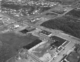
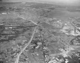
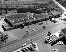
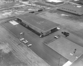
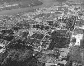
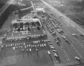
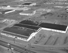
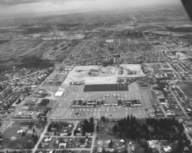
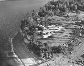
Aerial southbound look at the Gov-Mart South building in the Ponders Corner area on December 10, 1963. It was sandwiched on land between I-5 and Hwy. 99, across from McChord Field. Many cars in parking lot with plenty of room for more. A full page ad in the News Tribune on March 18, 1964, proclaimed Gov-Mart to be the Northwest's first and finest membership department store. It was open to government employees, armed forces members, school district employees and labor union members. Gov-Mart was holding a special public-invited sale in March, 1964, to perhaps increase membership. Photograph ordered by Puget Sound National Bank. (TNT ad 3-18-64, B-1)


Aerial photographs; Gov-Mart South (Lakewood); Department stores--Lakewood--1960-1970;

D140189-1

Aerial photographs looking northeast taken on December 10, 1963, on behalf of Puget Sound National Bank. The above photograph features Hwy 99 /I-5 at Ponders Corner. Nyanza Park is in the heavily forested area on the left, and Porter Woods is the forested area to the right.


Aerial photographs; Neighborhoods--Lakewood--1960-1970; Express highways--Lakewood;

D140189-13

December 10, 1963, aerial view looking northeast of I-5/Gravelly Lake Dr. interchange at Ponders. This has been identified as the Nyanza Park neighborhood of Lakewood. Woods to the left of highways are the Nelson Woods; Hillcrest St. is visible within woods. Water tower is found nearby surrounded by trees. McChord Field is on the upper right; Tacoma Country & Golf Club on lower left corner. Photograph ordered by Puget Sound National Bank.


Aerial photographs; Neighborhoods--Lakewood--1960-1970; Express highways--Lakewood;

D140419-3

This aerial view of the Lakewood area and I-5 dates from December, 1963. Gravelly Lake is to the left of I-5; the southern tip of Steilacoom Lake is on the left edge of the image. As you travel northeast on I-5, by moving up the image, the Lakewood Mall can be found to the left and McChord AFB to the right. Near the top left corner a plume of smoke floats above the St. Regis Paper Co. mill on the Tacoma tideflats. (Photograph ordered by Puget Sound National Bank.)


Aerial photographs; Neighborhoods--Lakewood--1960-1970; Lake Steilacoom (Wash.); Gravelly Lake (Wash.); American Lake (Wash.); Express highways--Lakewood;

D140600-35

Richards stock footage, February, 1964. Aerial view of city's south side, including Tacoma Mall at upper center with the Bon Marche standing alone; the 2.6 million dollar Tacoma Public Utilities Center on So. 35th St. is large structure toward the right corner of photograph. Union Ave. runs parallel to the public utilities building; City Water plant/shop is believed to be on Union across from Public Utilities Center.


Aerial photographs; Tacoma Dept. of Public Utilities, Light Division (Tacoma); Shopping centers--Tacoma--1960-1970;

D140600-241

Stock footage taken on June 23, 1964, of So. 19th & Union Ave. and vicinity. The H-shaped Unionaire Apartments was just one of the many new building projects in the So. 19th & Union Ave. location in 1964. Wooded area across the street would become the Allenmore Medical Center. Tacoma Elks had started construction of their new temple at 1965 So. Union Ave. at the Allenmore Golf Course.


Aerial photographs; Unionaire Apartments (Tacoma);

D140600-173

Aerial stock footage of Washington Steel Products, Inc., plant taken on May 14, 1964. The plant was built in 1948 with additions in 1950, 1952 and a major expansion in 1953. It was located in the Tideflats at 1940 E. 11th St near Thorne Rd. Washington Steel Products was the only Northwest manufacturer of builder's hardware. By 1965 this location was listed in the City Directory as the Brown & Haley Candy Co. Distribution Division.


Aerial photographs; Washington Steel Products, Inc. (Tacoma);

D142189-6

Aerial photography looking eastward of the Port of Tacoma and industrial Tideflat areas and sections of Tacoma's north end neighborhoods. Taken in July, 1964, by request of Puget Sound National Bank. Dash Point on the upper left, various Tacoma waterways toward upper center. Bantz Blvd. (Hwy 16) at bottom; Cheney Stadium above it on the right. Tacoma Auto View Drive-in Theater is in left corner on Pearl. Wilson High School at 12th & Orchard directly above. TPL-9159


Aerial photographs; Dash Point (Wash.); Cheney Stadium (Tacoma); Woodrow Wilson High School (Tacoma);

D142189-9

There were large tracks of undeveloped land along both sides of I-5 in July of 1964 when this aerial view of Federal Way and the 348th Street interchange was taken. To the north and west, above I-5 in the picture, are Tacoma, the tideflats, Puget Sound, and both Browns Point and Dash Point. Beyond Tacoma and Puget Sound, near the top of the picture are (in no particular order), McNeil Island, Fox Island, Gig Harbor and the Key Peninsula.


Aerial photographs; Fox Island (Wash.); Express highways--Tacoma--1960-1970;

D141601-12

Aerial photographs of the Lakewood community featuring the three major lakes. Taken on a hazy day in late April, 1964, at an altitude of 5000 feet, Steilacoom, Gravelly and American lakes are shown surrounded by massive trees. Interlaaken Bridge crosses the Steilacoom Lake to the left. McChord AFB is on to right side. Ponders Corner also on the right. Tacoma Country & Golf Club is on the shores of American Lake. Photograph ordered by Puget Sound National Bank. TPL-9666


Aerial photographs; Lake Steilacoom (Wash.); American Lake (Wash.); Gravelly Lake (Wash.); Neighborhoods--Lakewood--1960-1970;

D141028-3

Aerial photograph of S.S. Tiha streaming into port at Aberdeen, Washington, in early March, 1964. Photograph ordered by Export Pacific.


Aerial photographs; Ships--Aberdeen;

D141559-1

Aerial photographs of the Villa Plaza Shopping Center and surrounding Lakewood neighborhoods were taken from a modest 2000 feet altitude on April 26, 1964. Low cloud coverage that day prevented higher elevations. Located between Gravelly Lake and Bridgeport Way in the heart of Lakewood, the large shopping center provided the convenience of one-stop shopping for its suburban clientele. The 4000-car parking lots ensured that customers did not have to hunt for parking space. View of Villa Plaza; Lost Lake on the left side of photograph. Park Lodge Elementary School, now demolished, is also on left bottom. East of Villa Plaza is the Lakeview neighborhood. Puyallup freeway is on very top. Photograph ordered by Puget Sound National Bank.


Aerial photographs; Villa Plaza Shopping Center (Lakewood); Shopping centers--Lakewood--1960-1970; Neighborhoods--Lakewood--1960-1970;

D142699-17

Overhead view of Ketron Island featuring large structure, either a hotel or luxurious residence, on September 6, 1964. This building, and others, are built on slight hillsides buffeted with trees very close to the water. The sandy beach is not very wide with driftwood piled nearby and two rowboats at the foot of the wooden bridge.


Aerial photographs; Buildings--Ketron Island; Rowboats--Ketron Island; Beaches--Ketron Island;

D142314-6

Aerial southeast view of new shopping center under construction near Ponders Corner, July, 1964. This unidentified retail center is bordered by Bridgeport Way on the bottom and Hwy. 99 near top. I-5 is at extreme top. Side road on left half of photograph is now 115th St. Ct. SW. Shopping center already has a laundry/dry cleaners, real estate firm and car wash. The large new building under construction left of the car wash is the upcoming Prairie Market; in 2006 it has been identified as now being the Happy Days Casino. The building in the lower left has been identified in 2006 as the Lakeview Light & Power headquarters; the looping line painted in the parking lot leads cars through their drive-up window. A reader has indicated that a Sound Transit station is scheduled to be built in the extreme upper left corner of the photograph. Photograph ordered by Arrowhead Estates. (Additional information provided by a reader)


Aerial photographs; Shopping centers--Lakewood--1960-1970; Building construction--Lakewood--1960-1970; Express highways--Lakewood;

D141943-A

Aerial photograph on June 23, 1964, of Browns Point residence of lumber magnate Ben Cheney. Richards Studio notes indicate that the pilot would not fly lower due to complaints from local residents. The large sprawling complex in the center of the photograph was the Cheney estate, including the swimming pool and guesthouse on the left and private tennis court at the edge of the large stand of timber. The Cheneys, along with their near neighbors, sported well-manicured lawns. Photograph ordered by Cheney Lumber Co. (Additional information supplied by Eric Swanson) TPL-9417


Aerial photographs; Cheney, Ben B., 1905-1971--Homes & haunts;

D142189-4

Aerial photographs of the Port of Tacoma and industrial Tideflats taken in early July, 1964 as requested by Puget Sound National Bank. Looking north, photograph also shows thickly clustered Tacoma neighborhoods of the North and South ends in contrast with the much roomier Puyallup Valley areas. Besides the various waterways, including the City (now Thea Foss) Waterway connecting the business downtown area with the Tideflats, the widely channelized Puyallup River is clearly visible running from the right edge. Curving road left of the Puyallup River is Pioneer Way. Salishan and Swan Creek Park areas are in the wooded section left center. I-5 construction is also underway.


Aerial photographs; Puyallup River (Wash.);

D141601-8

Bridgeport Way is the curving road on the left side of this April 30, 1964, aerial photograph of Lakewood. The Lakewood Center, one of the earliest shopping centers in the country, is east of Bridgeport near the photo's bottom. The larger Villa Plaza Shopping Center, with its enormous 4000-car parking lot, is in the photo's center. McChord AFB is in the left top corner. Steilacoom Lake is on the right. Photograph ordered by Puget Sound National Bank.


Aerial photographs; Shopping centers--Lakewood--1960-1970; Villa Plaza Shopping Center (Lakewood); Lakewood Community Center (Lakewood); Lake Steilacoom (Wash.); Neighborhoods--Lakewood--1960-1970;

D141601-3

This aerial view of Lakewood from April of 1964 shows the area east of Steilacoom Lake and south of the Villa Plaza Shopping Center (currently Lakewood Towne Center). I-5 cuts across the top, with McChord Air Force Base in the top left corner. Clover Park High School is in the center of the image just above the shopping center. Steilacoom Lake is at the far right, with Gravelly Lake above it. Photograph ordered by Puget Sound National Bank.


Aerial photographs; Villa Plaza Shopping Center (Lakewood); Shopping centers--Lakewood--1960-1970; Clover Park High School (Lakewood); Lake Steilacoom (Wash.); Neighborhoods--Lakewood--1960-1970;

D142699-16

Located on a hillside at the edge of Ketron Island in September, 1964, was a large structure, either a luxurious residence or hotel. This aerial view shows how close it was built to the water with small beach below. Two rowboats and driftwood are located near a wooden bridge extending into the water.


Aerial photographs; Rowboats--Ketron Island; Buildings--Ketron Island; Beaches--Ketron Island;

D142647-1

This aerial view of St. Regis Paper Company's chip operations was taken in mid-September of 1964. A barge marked "Vancouver Tug" unloads tons of pulp-mill chips at the Tacoma kraft mill of St. Regis Paper. Two large mountains of chips are in storage outside side-by-side. Photograph ordered by Malcolm McGhie, industrial consultant, New York.


Aerial photographs; St. Regis Paper Co. (Tacoma)--1960-1970; Paper industry--Tacoma--1960-1970; Barges--Canada--Vancouver;

Results 1 to 30 of 55