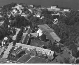
Although Annie Wright Seminary had been at this location, 827 Tacoma Ave. No., only since 1924; it was in the process of celebrating its Diamond Jubilee in October of 1958 when this picture was taken. The first class of 93 girls entered Annie Wright in the fall of 1884 in the school's first building at Tacoma & Division Avenues. Annie Wright experienced financial troubles due to decreased enrollment in the 1930's and increased expenses during the early part of WWII; the school was nearly forced to close in 1943. Headmistress Ruth Jenkins and the Board of Trustees were given 48 hours to raise enough money to pay the most outstanding debts. Friends, alumnae and students rallied to save the school. Annie Wright Seminary continued to expand with a new wing added in 1957. In 2002, the school had pupils from seven states and eight countries and was planning to add a 10.3 million three story addition. (The Shield:1959, TNT 9-30-02, B-1)
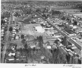
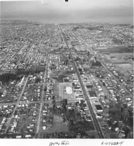
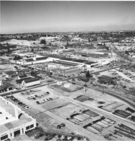
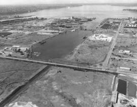
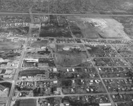
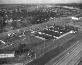
Aerial photographs taken on behalf of George Franklin on November 3, 1958, of the South 84th and Pacific Avenue neighborhoods show a growing southend presence in the city. While there appears to be room for development, Pacific Avenue around this area is starting to develop with many businesses. Safeway, Vaughan's Pacific Avenue Lumber and Puget Sound National Bank all are close by.
Aerial photographs taken on November 3, 1958, show Tacoma city streets neatly gridded and stretching into the horizon. This area was the South 84th & Pacific Avenue neighborhood. A few large businesses had started to relocate to this southend location including Puget Sound National Bank, Safeway, and Vaughan's Pacific Avenue Lumber Co. Pacific Avenue was a major thoroughfare and businesses located on or near it attracted much drive-by traffic. Photograph ordered by George Franklin.
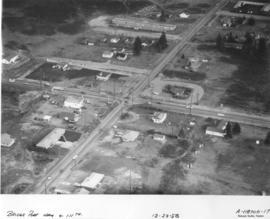
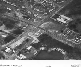
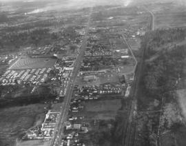
Aerial photographs of the 111st St. and Bridgeport Way S.W. neighborhood were taken by Richards on December 22, 1958. They were photographing various city neighborhoods by air that day for inclusion in sample books. This area was also known as Lakeview. Belcher Realty's large signage on Bridgeport can be clearly seen from the air; it was owned and operated by Lyle V. Belcher, broker. The realty firm handled homes, farms, acreage and insurance in the Lakes area. Next to Belcher's was Bridgeport Service, a gas station owned by Wesley Baker and James Bohannon. The Bell Fuel Co. had their suburban facility on 111st St. It was a Mobilheat dealer and sold stove and diesel oil. It is possible that across the street from Bell Fuel was the A.A. Meat Co.
Aerial photographs; Neighborhoods--Lakewood--1950-1960; Belcher Realty (Lakewood); Bell Fuel Co. (Lakewood);
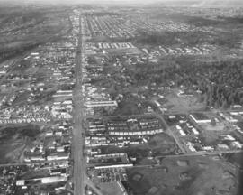
The Richards Studio worked even on New Year's Day as they took some aerial photographs of the 108th St. and Bridgeport Way S.W. area. Ellie's Shell Service was located at 10808 Bridgeport Way S.W. It appears to have had six pumps and a garage. Behind Ellie's was a brushy area with a flooded gravel pit. This was a growing area and there were many homes and apartment units scattered along these streets. There appeared to be still more room for expansion.
Aerial photographs; Neighborhoods--Lakewood--1950-1960; Ellie's Shell Service (Lakewood);
Aerial photographs of the Skyline Terrace neighborhood were taken in November, 1958, by the Richards Studio for a sample book. Immense tracts of trees surround the North end neighborhood close to the Narrows Bridge. Skyline Terrace was an exclusive neighborhood developed by builder Ed Miller; all homes had views of either the Narrows Bridge, the mountains or city lights. This photograph was supposedly taken in the vicinity of No. 11th & James.
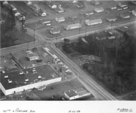
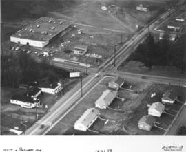
It appears that new construction is going up in the vicinity of E. 40th & Portland Ave. in late December, 1958. The smaller unit closer to the intersection is a gas station. The identity of the larger rectangular building is not certain; it may have been a grocery store. The carefully spaced houses across the street from the gas station are part of the Salishan housing project, which was originally built as housing for war workers and military families. The first family moved into Salishan in 1943; the neighborhood consisted of one-story units, single family, duplexes, and four-family units. Aerial photographs were taken on December 22, 1958, by the Richards Studio for a sample book.
Aerial photographs of the E. 40th & Portland Avenue neighborhood were taken on December 22, 1958, by the Richards Studio for inclusion in a sample book. A church and Dairy Queen stand side-by-side across the street from the neatly aligned homes of the Salishan housing development. Each unit in Salishan had a fairly large grass yard; clothes can be spotted hanging to dry in the backyards. New construction is taking place in the upper left hand corner as a gas station and another large building, a new Piggly Wiggly supermarket, are being built. The Piggly Wiggly would open on March 18, 1959. (Additional information provided by a reader)
Aerial photographs; Neighborhoods--Tacoma--1950-1960; Building construction--Tacoma--1950-1960;
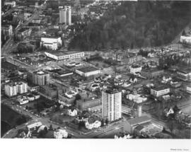
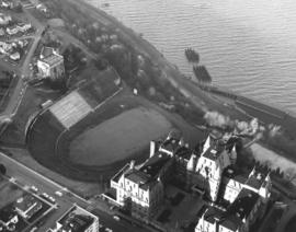
Stadium District aerials were taken by Richards Studio on December 22, 1958, for inclusion in a sample book. To the far left corner is a glimpse of Stadium Bowl. The high school is not visible in this picture. Division and Tacoma Ave. are toward the upper left with the heavily wooded area Wright Park. First Presbyterian Church is on Tacoma Ave. So.; the large white building next to it is the Scottish Rite Cathedral at 5 S G St.
Aerial photographs; Neighborhoods--Tacoma--1950-1960; First Presbyterian Church (Tacoma);
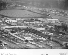
This aerial photographs of the area around South 80th & South Tacoma Way, close to Tacoma's city limits, was taken in December of 1958. Before I-5 was built, South Tacoma Way was part of highway 99. It was a major thoroughfare and businesses located along it had excellent exposure to traffic. South Tacoma Way was known for its many car lots and for such attractions as the B & I shopping center and the Star-Lite Drive-In, both pictured above. The Star-Lite, built in 1948, was one of the world's largest outdoor theaters. It was built with a 39 by 54 foot screen with over three acres of parking. The B&I was originally built in 1946 and as it grew over time it became known as the "biggest little store in the world." Owner E.L. Irwin advertised heavily and was instrumental in bringing celebrities such as Duncan Renaldo ("The Cisco Kid") and boxers Max Baer and Joe Louis to town.
Aerial photographs; Neighborhoods--Tacoma--1950-1960; Star-Lite Park In Theatre (Tacoma); B&I Circus Store (Tacoma);
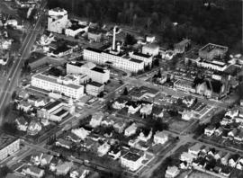
Mary Bridge-Tacoma General Hospital off Division. Aerial photographs of the So. "K" (now Martin Luther King, Jr. Way) and So. "L" Streets were taken just prior to Christmas, 1958. Division Avenue is the street to the extreme left. Tacoma General Hospital, located in the 300 block of So. "K", is the multi-storied white building with dark roof and smokestack. First Christian Church in the 500 block of So. "K" is to the right of the picture. Mary Bridge Children's Hospital is directly in front of Tacoma General in the 300 block of So. "L;" it was dedicated in March, 1955. Wright Park is the wooded area to the top of the photograph.
Aerial photographs; Wright Park (Tacoma); Mary Bridge Childrens Hospital (Tacoma); Tacoma General Hospital (Tacoma);
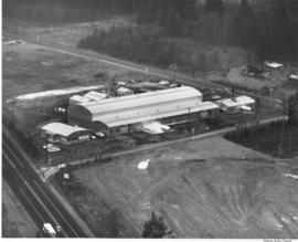
For several years the Huntington Rubber Mills in Seattle had their plant annually photographed from the air. This is believed to the be plant located at 34315 - 16th South. At that time the area was still relatively open for expansion; there are large sections of trees and an enormous dirt or gravel pit. The plant was situated on a plot of land between two roadways. The long buildings with the semi-curved roofs are probably the plant itself; the smaller building with extended roof the office. There were other assorted smaller units clustered around the plant. Photograph ordered by Huntington Rubber Mills.
ca. 1959. Aerial of "Nalley Valley, " circa 1959. Tacoma Municipal Water Works building in the lower left hand corner. All of the buildings in the center of the picture, to the left of the railroad tracks, belong to Marcus Nalley's vast food production empire. Nalley's was founded in Tacoma in 1918 and grew rapidly due to the quality of their products. By 1959, their food production was centered in "Nalley Valley" where they produced potato chips, pickles and salad dressing, just to name a few products.
Nalley Valley (Tacoma); Nalley's, Inc. (Tacoma); Food--Tacoma--1950-1960; Food industry--Tacoma--1950-1960; Aerial photographs;
Aerial view of Stadium District in the city's northend, including turreted Stadium High School, Stadium Bowl, and State Historical Museum on the hillside overlooking the Bowl and with views of Commencement Bay. The school's tennis courts are to the right. Part of Richards stock file, taken on February 9, 1963. TPL-10143
Aerial photographs; Stadium High School (Tacoma); Public schools--Tacoma--1960-1970; Stadium Bowl (Tacoma); Washington State Historical Building (Tacoma); Washington State Historical Society (Tacoma); Neighborhoods--Tacoma--1960-1970;
ca. 1963. 1963 aerial photograph of scenic Surprise Lake. Located in the Milton area, with Puyallup in the background, Surprise Lake, surrounded by trees, was a popular location for swimming and probably boating.
Aerial photographs; Surprise Lake (Milton); Lakes & ponds--Milton;
ca. 1963. Another of a series of aerial photographs taken in 1963 of the neighborhoods around Tacoma Avenue North, featuring the white tower of Vista Manor Apartments and the Central Lutheran Church. Many of the dwellers of "Old Town, " including Vista Manor occupants, would have splendid views of the water. TPL-868
Aerial photographs; Vista Manor Apartments (Tacoma); Central Lutheran Church (Tacoma); Neighborhoods--Tacoma--1960-1970;
View by air of Washington State Historical Building and vicinity on No. Stadium Way on August 24, 1963. No. 4th is the next street over. Large empty space is believed to be the museum's parking lot. This section of the Historical Society's building would overlook the waters of Commencement Bay which would be visible beyond the trees.
Aerial photographs; Washington State Historical Building (Tacoma); Washington State Historical Society (Tacoma); Neighborhoods--Tacoma--1960-1970;
ca. 1963. Scenic view by air of the Edgewood area in 1963. Croplands are framed and bordered by stands of trees. More heavily populated areas in the far distance. This has been identified as the intersection of Meridian & 36th St. E. (additional information provided by a reader) TPL-9390
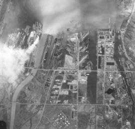
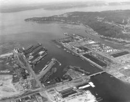
ca. 1963. Aerial view of Tacoma Tideflats industrial area taken in 1963. Floating log dumps in various waterways. Lighter colored waterway to the left is the Puyallup. Smoke billows from one of the many plants, possibly St. Regis. TPL-2247
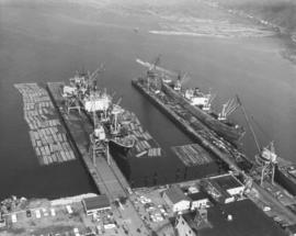
Aerial photograph of ships docked in Hylebos Waterway taken on August 24, 1963. Log booms float near docks. A small tug streams toward open waters. Photograph ordered by the Port of Tacoma.
Aerial views of the Tacoma Tideflats area were taken in late August, 1963. There is still room for expansion in areas close to the waterways which lead into Commencement Bay. The close proximity of roadways and rail would mean that Tacoma was not limited to transporting their industrial and wood products only by water. A small piece of Browns Point can be spotted to the far right; City of Tacoma businesses to the far left. Waterway is the Port Industrial with the Blair Bridge. Roadway extending width of photograph is Lincoln Ave. Photograph ordered by Port of Tacoma. TPL-2258
Aerial photographs; Port Industrial Waterway (Tacoma);
Water views of Tideflats area taken by air in late August, 1963. Easy access by water, rail and highways made transport of industrial and wood products convenient and efficient for the many companies doing business in the Tideflats area. Browns Point juts into the water in the above photograph. Thick stands of trees flank the Hylebos Waterway on one side. Next waterway is the Port Industrial with the Blair Bridge visible on 11th St. Photograph ordered by the Port of Tacoma. TPL-8725 TPL-10518
Aerial photographs; Port Industrial Waterway (Tacoma); Hylebos Waterway (Tacoma);
This was how the Cliff House Restaurant on Browns Point, center front, appeared from the air on June 23, 1964. Perched on a hillside overlooking Tacoma's waterfront, the Cliff House Restauant provided its customers with fine cuisine and scenic views. Originally built as a tavern in 1925, it was later remodeled and rebuilt after a massive fire in 1958. Houston "Hugh" O. Smith was still the owner in 1964.
Aerial photographs; Aerial views; Cliff House Restaurant (Tacoma); Restaurants--Tacoma--1960-1970; Neighborhoods--Tacoma--1960-1970;
Aerial photographs of So. 38th & Pine & freeway taken in February, 1964; stock footage. So. 38th St. cloverleaf upper left; I-5 runs across top portion of photograph. This focuses on the location of the upcoming Tacoma Mall Shopping Center. The Bon Marche, the first store built at the Mall, is the massive building standing alone in large otherwise vacant lot. The wooded area near the Bon would change soon as the Mall expanded; the National Bank of Washington and J.C.Penney had already announced plans to build in the Mall area and other stores would later join them. The circular building in the center is part of Madison School.
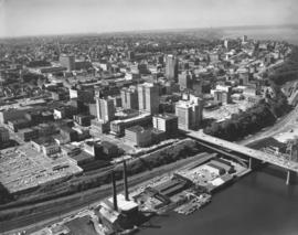
Stock footage, 1964. Aerial view of downtown Tacoma business district looking toward Point Defiance, taken on September 30, 1964. The ASARCO smelter can barely be seen in the distance. Closer focus is on portions of A St., Pacific Ave., and Tacoma Ave. So. with its multitude of tall buildings. Tacoma Building and Perkins Building flank the 11th Street Bridge which crosses the City (now Thea Foss) Waterway. Puget Sound National Bank, Washington Building, Rust Building, Peoples store, are closer to the waterway with the County-City Building, Tacoma Public Library and Central School on Tacoma Ave. So., several blocks away.
Aerial photographs; Commercial streets--Tacoma--1960-1970; 11th Street Bridge (Tacoma); City Waterway (Tacoma); Perkins Building (Tacoma); Tacoma Building (Tacoma); Washington Building (Tacoma); Rust Building (Tacoma); County-City Building (Tacoma);
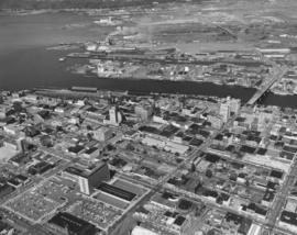
1964 stock footage. Downtown business district and industrial Tideflats area are captured in this June 23, 1964, aerial photograph. 11th Street Bridge crosses the City (now Thea Foss) Waterway into the bustling Tideflats. Smoke can be seen rising from St. Regis Paper Co. whose operations ran 24 hours a day. Prominent structures in the downtown area included the Tacoma Bldg., Perkins Bldg., Puget Sound National Bank, Washington Bldg., Rust Bldg., Medical Arts Bldg., and further to the lower portion of the photograph, the County-City Building and Tacoma Public Library. State Armory is also located at bottom's edge.
Aerial photographs; Commercial streets--Tacoma--1960-1970; County-City Building (Tacoma); Tacoma Public Library (Tacoma); 11th Street Bridge (Tacoma); City Waterway (Tacoma); St. Regis Paper Co. (Tacoma)--1960-1970; State Armory (Tacoma);
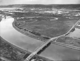
This aerial view of the channelized Puyallup River as it flows through the Tacoma tideflats dates from February of 1964; the East 21st Street Bridge is at the bottom, center. Nearer to the mouth of the River, in the left corner, are the East 11th Street Bridge and the old Milwaukee Road railroad bridge. There is little development between East 11th Street and Lincoln Avenue. The buildings in the Port of Tacoma can be seen in the distance and Northeast Tacoma is on the horizon.
Aerial photographs; East 21st Street Bridge (Tacoma); Bridges--Tacoma;
Aerial view of Gov-Mart South building between Hwy. 99 and I-5 on December 10, 1963. Gov-Mart South was a discount department store. In the upper left can be spotted Clover Park Vocational School. In the upper right corner beyond the trees is the Southgate housing development. Photograph ordered by Puget Sound National Bank.
Aerial photographs; Gov-Mart South (Lakewood); Department stores--Lakewood--1960-1970; Express highways--Lakewood;
Aerial view looking south on Hwy 99 (South Tacoma Way) taken on December 10, 1963. McChord Field can faintly be seen in the background. Spanaway Lake is believed to be in the upper left corner area. Clover Park Vocational to the far right. Star-Lite drive-in left center. Photograph ordered by Puget Sound National Bank. TPL-9303
Aerial view of South Tacoma Way and vicinity on December 10, 1963. Star-Lite drive-in theater is believed to be towards upper right center. Port of Tacoma in the distance, upper right corner. Photograph ordered by Puget Sound National Bank.