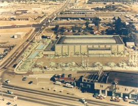
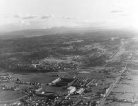
ca. 1971. Aerial view of former Tacoma Sports Arena with artist's rendering of possible architectural changes. Ben's Truck Parts had purchased the Tacoma Sports Arena (known prior as the Tacoma Ice Palace) on September 3, 1971. The company had commissioned the Richards Studio to take several aerial photographs of the Arena and vicinity. This aerial view shows possible architectural changes to the building and site with shimmering pools facing So. 38th St. and a profusion of trees and shrubs added. The exterior of the building would also change with walls apparently extended and a changed roofline. The location was easily accessible by traveling on So. 38th St. (now one of the city's busiest streets due to the close proximity to the Tacoma Mall), South Tacoma Way, and from the north, Union Ave. Color photograph ordered by Ben's Truck Parts.
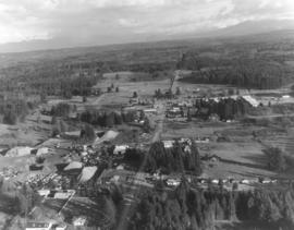
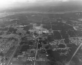
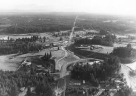
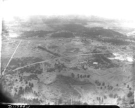
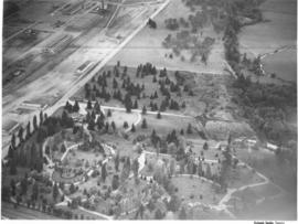
This aerial view of the Puyallup neighborhoods near 112th & Meridian was taken by the Richards Studio on January 2, 1972, on behalf of Puget Sound National Bank. Sand and gravel pit on the left; sprinkling of homes and businesses nearby.
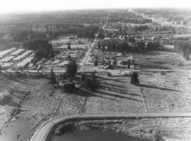
Another in a series of aerials of the area around 112th & Meridian in early 1972. In the late 1980s, the South Hill Mall would be built about this location. Photograph ordered by Puget Sound National Bank.
This is what the 112th & Meridian area looked like in early 1972. The South Hill Mall would be built 16 years later on Meridian. What is noticeable is the large amount of woods and relatively few homes. Aerial photograph ordered by Puget Sound National Bank.
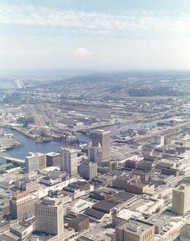
1971 color Richards stock footage. Aerial northeast view of downtown Tacoma overlooking City (now Thea Foss) Waterway and industrial Tideflats. The snowy tip of Mount Rainier is barely visible through the haze. Wheeler-Osgood Waterway is the small waterway on the left which leads into the City Waterway. Major buildings of note in downtown area include Tacoma and Perkins Buildings flanking the 11th Street Bridge (now Murray Morgan Bridge); the cluster of buildings on Pacific including Washington and Rust Buildings, Puget Sound National Bank, the new Bank of Washington Plaza, and Schoenfelds Furniture to the right. Neighborhoods seen in the distance to the center and right of photograph are part of East Tacoma.
Aerial views; City Waterway (Tacoma); Wheeler-Osgood Waterway (Tacoma); Tacoma Building (Tacoma); Perkins Building (Tacoma); Washington Building (Tacoma); Rust Building (Tacoma); Puget Sound National Bank (Tacoma); 11th Street Bridge (Tacoma);
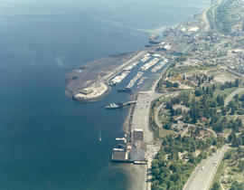
1971 color Richards stock footage. Aerial view of Point Defiance and vicinity. The Point Defiance Park is on the right with the Boathouse prominently displayed. The ferry landing and Tacoma Yacht Club and mooring are in the upper center. ASARCO (American Smelting & Refining Co.) is near the top with a glimpse of the giant smokestack along the right upper edge.
Aerial views; Point Defiance Park (Tacoma); Parks--Tacoma--1970-1980; Boathouses--Tacoma; Boats; Tacoma Yacht Club (Tacoma); Mooring; American Smelting & Refining Co. (Tacoma); Smelters--Tacoma--1970-1980;
The 112th & Meridian neighborhoods as seen by air in January of 1972. At that time there was an abundance of wooded acreage and not many homes. Photograph ordered by Puget Sound National Bank.
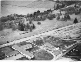
Closer view of Puyallup neighborhood about 9th Ave. S.W. and Meridian South with Western Washington Fairgrounds in lower center. This photograph, one of a series, was taken on January 2, 1972, on behalf of Puget Sound National Bank.
Aerial views; Neighborhoods--Puyallup--1970-1980; Western Washington Fair (Puyallup);
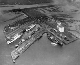
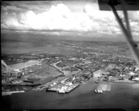
This aerial view, taken January 13, 1940, shows the Port of Tacoma piers with two docked, white transport ships. Three transport ships, the Hunter Liggett, Leonard Wood and St. Mihiel, were in Commencement Bay to transport over 7,500 soldiers from Fort Lewis to the biggest war games in US history. This is the biggest passenger embarkation in the history of the Tacoma port. The troops will invade the California coast from the sea. They will strike at an undisclosed location somewhere on the 400 mile coast between San Francisco and Santa Barbara. This will be the major offensive of the war games to be held January 15-22nd. Also in the photograph are the Co-op's white grain elevators; the waterway is crowded with log booms. The two other cargo vessels pictured are believed to be the South American freighter Coya and the Japanese freighter Koei Maru. ( T. Times 1-3-40, p. 1-article; 1-11-40, p.1-article; 1-13-40, p.1-article)
Aerial photographs; Bays--Washington (State); Commencement Bay (Wash.); Port of Tacoma (Tacoma)--1940-1950; Logs; Ships; Piers & wharves--Tacoma--1940-1950;
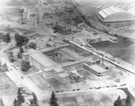
This aerial view of McChord Field from June of 1940 shows the U.S. Army's Northwest airbase shortly before it was dedicated on July 3rd. The massive building in the center is the new enlisted men's barracks which could house 1,200 men. In the upper right corner are two of the six-story tall hangers that housed the base's fleet of 24 Douglas B-18A "medium" bombers. The Army had already spent $7 million building the airbase, and millions more would be needed before it was completed. (T.Times 7/1/1940 p.1)
ca. 1939. Associated Oil Company aerial view of west side cement plant for first Narrows Bridge construction. Ordered by George Martinac, North Pacific Bank Note.
Aerial view of Northern Pacific Rail property at Lakeview which was taken on August 22, 1941. Land is dotted with trees in foreground with thicker forests toward the top of the photograph. Few, if any, homes in sight. Ordered by Raleigh -Hayward Company.
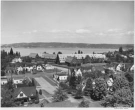
Annie Wright Seminary was a college preparatory school for girls. Miss Ruth Jenkins was the headmistress of the school. Aerial view of Annie Wright Seminary, Commencement Bay in background.
1941 Aerial view of Sea-Tac Shipyard with Peterman Manufacturing Company in foreground, looking west. The Peterman Co. manufactured fir doors and veneer panels. It was forced to vacate the property in June of the following year as the Shipyard needed space to build the many ships under contract.
An aerial view of the Feltrok Insulation Manufacturing Company taken at 7 p.m. June 9, 1950. The company was located on the Tacoma tideflats. Pennsylvania Salt Manufacturing Company is seen on the right. Feltrok was purchased by the American Rock Wool Corporation in 1952. About 35 persons were employed in the Tacoma operation at that time. (Tacoma Reporter, 7/21/1952, p.3)
Aerial photographs; Feltrok Insulation Manufacturing Co. (Tacoma); Industrial facilities--Tacoma--1950-1960; Pennsylvania Salt Manufacturing Co. of Washington (Tacoma);
An aerial view of St. Paul and Tacoma Lumber Company. Colonel Chauncey Griggs, Addison Foster, Henry Hewitt, Jr. and Charles Hebard Jones purchased 83,000 acres of timber in 1888 from the Northern Pacific Raillroad company in the largest purchase of timberland in the nineteenth century. Then they built a giant sawmill on "The Boot", a low island off the main tideflats, bordered by branches of the Puyallup River and Commencement Bay. They built the first standard-guage logging railroad and introduced the band-saw to Pacific Northwest lumber operations. They built the St. Paul & Tacoma Lumber Company. (The Mill on the Boot, Murray Morgan)
Aerial photographs; Lumber industry--Tacoma--1950-1960; St. Paul & Tacoma Lumber Co. (Tacoma);
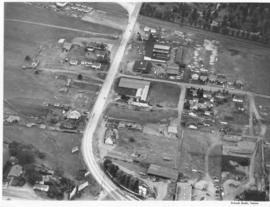
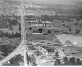
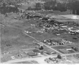
ca. 1950. Aerial view of Steilacoom Blvd. near South Tacoma Way was taken probably in the fall of 1950. Although houses and businesses dot the landscape, there was still plenty of room for expansion.
ca. 1950. Aerial view of Mountain View Cemetery on Steilacoom Blvd.; photograph taken probably in the fall of 1950. The Pacific Naval Advance Base, also known as the Lakewood Navy Yard, lies across the street. Mountain View was a very large memorial park; among its facilities included a cemetery, funeral home, chapel, crematorium and mausoleum. According to an advertisement in the 1951 City Directory, a mourner could place complete responsibility in the very capable hands of Mountain View.
Aerial photographs; Mountain View Memorial Park (Lakewood); Pacific Naval Advance Base (Lakewood); Lakewood Navy Yard (Lakewood);
ca. 1950. Aerial photograph of Pacific Naval Advance Base in Lakewood taken probably in the fall of 1950. Mountain View Cemetery with its expansive grounds lies across the street on Steilacoom Blvd. The Navy acquired the land to build its base in 1944; previously it had been used for the Tacoma Municipal Airport. The Pacific Naval Advance Base was also known more familiarly as the Lakewood Navy Yard.
Aerial photographs; Pacific Naval Advance Base (Lakewood); Lakewood Navy Yard (Lakewood); Mountain View Memorial Park (Lakewood);
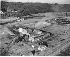
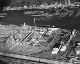
Aerial view shows progress being made on new construction for the St. Regis Paper Company in September, 1950. Established as a company in 1899, St. Regis was open for business in Tacoma in 1928. Rebuilt and modernized in 1936, St. Regis bought additional acreage from the St. Paul Tacoma Lumber Company in 1947 to add a paper mill and multi wall bag plant. According to the St. Regis 1950 annual report, Tacoma's expansion of their pulp mill would enlarge the pulp capacity from 115,000 to 135,000 tons a year. The new capacity will be in production in 1951.
St. Regis Paper Co. (Tacoma)--1950-1960; Paper industry--Tacoma--1950-1960; Factories--Tacoma--1950-1960; Progress photographs--1950-1960; Aerial photographs;
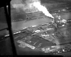
This aerial photograph from November 1948 shows the Hooker Electrochemical Company located at 605 Alexander Avenue on the Tacoma tideflats. The waterway above the plant, dotted with log booms, is the Hylebos Waterway. Small houses and businesses line the shore on the other side of the waterway along Marine View Drive. Hooker changed its name to Occidental Chemical Co. in 1982. In 1997 the company was purchased by Pioneer Companies Inc.; the plant closed in 2002. TPL-7977
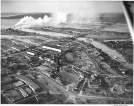
Aerial view of West Coast Grocery, St. Paul and Tacoma Lumber Company and Tacoma Iron and Steel. A view of the Tacoma tideflats and some of the industry built on it looking northwest. Log booms are seen in the waterways. One of the bridges on the Puyallup River is open. TPL-5892
Tacoma Tideflats (Tacoma); Aerial photographs; Puyallup River (Wash.); Industry--Tacoma--1940-1950;
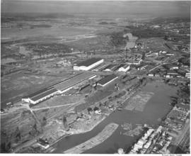
Aerial view of West Coast Grogery, St. Paul and Tacoma Lumber Company and Tacoma Iron and Steel. A view of the Tacoma tideflats and some of the industry built on it looking east. Log booms are seen in two of the waterways. TPL-3215 and TPL-3659
Tacoma Tideflats (Tacoma); Aerial photographs; Puyallup River (Wash.); Industry--Tacoma--1940-1950;
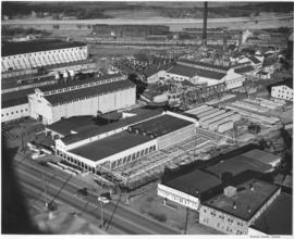
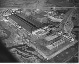
Permanente Metals, producers of Kaiser Aluminum, bought the Olin plant and after rehabilitating and improving the facilities, they have started production. They began operating one pot line, but within a month they should be producing aluminum at full capacity. The Tacoma plant is one of the most modern aluminum producing facilities in the country. Aerial view of Permanente, which is located on the Tacoma Tideflats, covering more than 129 acres of land (PMC Annual Report, 1947-48).
The Auto-View Theater was located on South Tacoma Way and South 99th Street. At 9915 South Tacoma Way was the Motel Fontaine, at the bottom center in this photograph. Aerial view of available area, neighborhoods and the Auto-View Theater (right side), all located along South Tacoma Way (T. Times, 8/31/48, p. 21).
Cities & towns--Tacoma; City & town life--Tacoma; Aerial views; Aerial photographs; Neighborhoods--Tacoma; Drive-in theaters--Tacoma; Auto-View Theater (Tacoma); South Tacoma Way (Tacoma);
Cooperation between South Tacoma employers and employees have played an important role in the steady growth of this south side community. South Tacoma businesses and industries have helped raise the overall payroll of the city. View of available area, neighborhoods and the Star-Lite Park In Theatre located along South Tacoma Way (T. Times, 8/31/48, p. 21).
Cities & towns--Tacoma; City & town life--Tacoma; Aerial views; Aerial photographs; Neighborhoods--Tacoma; Drive-in theaters--Tacoma; Star-Lite Park In Theatre (Tacoma); South Tacoma Way (Tacoma);
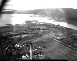
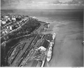
This aerial photograph shows the Tacoma shoreline looking north from the mouth of the City Waterway (Thea Foss Waterway) as it looked in October of 1948. Ships are taking on cargo at the terminals along Dock Street and the Shaffer Terminals on Bay Side Drive along the waterfront at the foot of Division Avenue. Boxcars fill the tracks in the Northern Pacific "half-moon yard". The Fourth Street Bridge provides access over the railroad tracks from Dock St. to Bay Side Drive. The smokestack in the distance is from the ASARCO facilities. This area was dramatically transformed with the building of I-705 and the Schuster Parkway.
Aerial photographs; Shaffer Terminals, Inc. (Tacoma); Marine terminals--Tacoma; Smokestacks--Tacoma;