Showing 9 results

Collections
Marvin Boland Photographs Aerial Photography Image With digital objects
Print preview View:

BOLAND-B2314

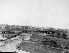
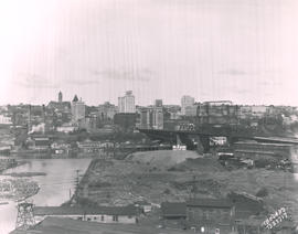
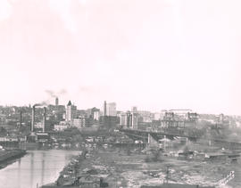
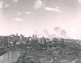
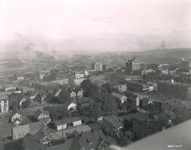
This is how downtown Tacoma and surrounding areas appeared in the fall of 1919. In the foreground are houses and apartments west of Pacific Avenue. A few Tacoma landmarks are clearly visible in the distance: the Puget Sound National Bank building with spire and close to the 11th St. Bridge (now Murray Morgan Bridge), the Tacoma Building and the Perkins Building. Smoke billows from the various industrial plants and lumber mills in the Tideflats across the City (now Thea Foss) Waterway. G8.1-026;


Aerial views; Aerial photographs; Cityscapes; Puget Sound National Bank (Tacoma); Tacoma Building (Tacoma); Perkins Building (Tacoma); 11th Street Bridge (Tacoma);

BOLAND-B22650

Aerial view of 146th F.A. tents on June 26, 1930. The 146th Field Artillery were participating in the 1930 encampment at Camp Murray. The two-week encampment of the Washington National Guard would last until June 28th. 2600 officers and men, including some 400 Tacomans, would participate in these annual summer maneuvers. Lake in background is American Lake. G77.1-040 (TNT 6-13-30, p. 1-article on encampment)


Aerial photographs; Aerial views; Washington National Guard, 148th F.A. (Tacoma); American Lake (Wash.);

BOLAND-B23720

This May, 1931, aerial view of Tacoma's City Center was taken from the industrial Tideflats. The 11th Street Bridge (now Murray Morgan Bridge) is on the right. Jutting into the skyline are (l-r) the Pierce County Courthouse, Puget Sound National Bank, Washington Building, Tacoma Building, and the Art-Deco styled 17-story newly completed Medical Arts Building in the right background. TPL-1788; G91.012


Cityscapes; Aerial views; Aerial photographs; 11th Street Bridge (Tacoma); Pierce County Courthouse (Tacoma); Puget Sound National Bank (Tacoma); Washington Building (Tacoma); Tacoma Building (Tacoma); Medical Arts Building (Tacoma);

BOLAND-B23717

Aerial view looking toward Tacoma's City Center. This May, 1931, view shows many prominent Tacoma landmarks including the Tacoma Building and Perkins Building flanking the 11th Street Bridge (now Murray Morgan Bridge); the newly completed 17-story Medical Arts Building (at center-right); the towering Washington Building at center; Puget Sound National Bank with spire (center-left) and the Pierce County Courthouse with tower in the far left background. TPL-1347; G8.1-021


Cityscapes; Aerial photographs; Aerial views; 11th Street Bridge (Tacoma); Tacoma Building (Tacoma); Medical Arts Building (Tacoma); Washington Building (Tacoma); Puget Sound National Bank (Tacoma); Pierce County Courthouse (Tacoma);

BOLAND-B15239

View by air in July of 1926 of the 146th Field Artillery camp at Camp Lewis. G69.1-137


Aerial views; Aerial photographs; Camp Lewis (Wash.);

BOLAND-B22651

View by air of the 161st Infantry tents at Camp Dent on the grounds of Camp Murray. Camp Dent was the name of the 1930 encampment of the Washington National Guard. Thick stands of trees block the view of American Lake. G69.1-138 TPL-10319


Aerial views; Aerial photographs; Washington National Guard, 161st Infantry (Wash.); American Lake (Wash.);

BOLAND-B14964

Aerial view of Tacoma's east side and Cushman Hospital. The hospital for veterans is the cluster of buildings in the center of this June, 1926, photograph. Surrounding homes are nestled in wooded lots.


Aerial views; Aerial photographs; Cushman Hospital (Tacoma); Hospitals--Tacoma--1920-1930; Neighborhoods--Tacoma--1920-1930;

BOLAND-B12169

Aerial view of City Center. Although taken in March of 1925, this view of Tacoma's City Center still shows the contrast between its office buildings and other edifices and the (then) relatively undeveloped industrial Tideflats across the waterway. The Pierce County Courthouse with its 230-foot tower can be seen in the distance; closer near the foreground are the Puget Sound National Bank Bldg. with its familiar spire, the nearly completed Washington Building, the smaller Rust Building, and nearest to the 11th St. Bridge (now Murray Morgan Bridge), the Tacoma Building. TPL-1778; G8.1-027A


Aerial views; Aerial photographs; Cityscapes; Office buildings--Tacoma--1920-1930; Pierce County Courthouse (Tacoma); Puget Sound National Bank (Tacoma);

BOLAND-B12170

View looking toward the City Center from the Wheeler Osgood plant in March of 1925. Dark smoke blots the spring skies and a few boats float placidly along the City Waterway. There is not much visible traffic on the nearby 11th St. Bridge (now Murray Morgan Bridge.) A similar view is Boland B12169. TPL-1346; G8.1-027B


Aerial views; Aerial photographs; Cityscapes; 11th Street Bridge (Tacoma);