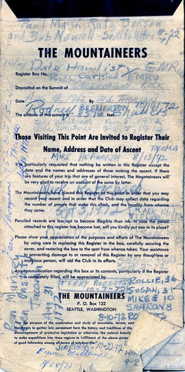
Summit Registry Book, 1971-1972
- Item
- 1971 - 1972
Part of The Tacoma Mountaineers Records
The Mountaineers Summit Registry Book with member signatures, address and date of ascent, 1971-1972
190 results with digital objects Show results with digital objects
Summit Registry Book, 1971-1972
Part of The Tacoma Mountaineers Records
The Mountaineers Summit Registry Book with member signatures, address and date of ascent, 1971-1972
Tacoma Mountaineers Topographic Maps Book
Part of The Tacoma Mountaineers Records
Oversized book of topographic maps (edition dates range from c. 1900-c. 1923, with reprint dates from c. 1920- c. 1925) and geological records provided by the U.S. Department of the Interior. Maps include the following: Washington State Index, Mt. Baker District, Mount Vernon, Stillaguamish, Glacier Peak, Stehekin, Methow, Okanogan, Sultan, Skykomish, Chiwaukum. Chelan, Tacoma, Cedar Lake, Snoqualmie, Mount Stuart, Wenatchee, Chehalis, Mount Aix, Ellensburg, Mount St. Helens, Mount Adams, Mount Hood (Ore.), Snohomish, Crater Lake National Park (Ore.), Mount Rainier National Park.
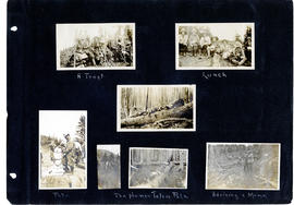
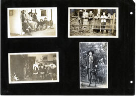
Mountaineers Scrapbook, 1912 to 1916, p. 3
Part of The Tacoma Mountaineers Records
The Mountaineers Summer Outing, July 20, 1912-August 10, 1913 Scrapbook, pg. 3. From captions, clockwise: A Treat, Lunch, Pete, The Human Totem Pole, Advising a Mome
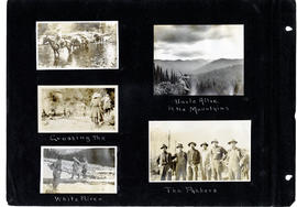
Mountaineers Scrapbook, 1912 to 1916, p. 4
Part of The Tacoma Mountaineers Records
The Mountaineers Summer Outing, July 20, 1912-August 10, 1913 Scrapbook, pg. 4. From captions, clockwise: Uncle Allie in the Mountains, The Packers, Crossing the White River
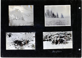
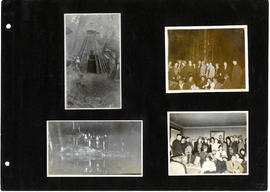
Mountaineers Scrapbook, 1912 to 1916, p. 8
Part of The Tacoma Mountaineers Records
The Mountaineers Summer Outing, July 20, 1912-August 10, 1913 Scrapbook, pg. 8. From captions, clockwise: TPL-10218, Heather
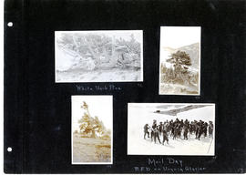
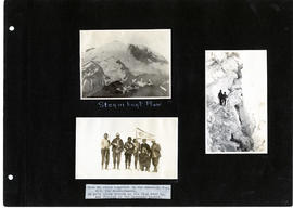
Mountaineers Scrapbook, 1912 to 1916, p. 13
Part of The Tacoma Mountaineers Records
The Mountaineers Summer Outing, July 20, 1912-August 10, 1913 Scrapbook, pg. 13. From captions, clockwise: White Bark Pine, Mail Day, R.F.D. on Urqniq Glacier
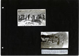
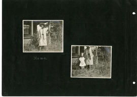
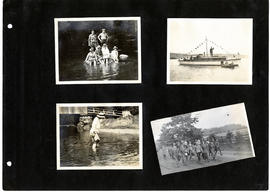
Mountaineers Scrapbook, 1912 to 1916, p. 15
Part of The Tacoma Mountaineers Records
The Mountaineers Summer Outing, July 20, 1912-August 10, 1913 Scrapbook, pg. 15. From captions, clockwise: Fall in the grub-line, every one in the grub-line. The Mountaineers are feeling very frisky and gay; Bacon and macaroni, pancakes and pickled pony, Everyone is hungry to-day
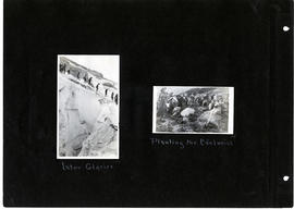
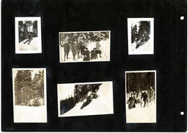
Mountaineers Scrapbook, 1912 to 1916, p. 18
Part of The Tacoma Mountaineers Records
The Mountaineers Summer Outing, July 20, 1912-August 10, 1913 Scrapbook, pg. 18. From captions, clockwise: Inter Glacier, Planting the Edelweiss
Mountaineers Scrapbook, 1912 to 1916, p. 19
Part of The Tacoma Mountaineers Records
The Mountaineers Summer Outing, July 20, 1912-August 10, 1913 Scrapbook, pg. 19. From captions, clockwise: Steamboat Prow. When we stood together on the mountain top, with The Mountaineers, We gave three cheer as the flag went up, and floated in the mountain breeze
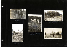
Mountaineers Scrapbook, 1912 to 1916, p. 25
Part of The Tacoma Mountaineers Records
The Mountaineers Summer Outing, July 20, 1912-August 10, 1913 Scrapbook, pg. 25. From captions, clockwise: Avey, Squaw Grass, Ritchie, Jess, Brud
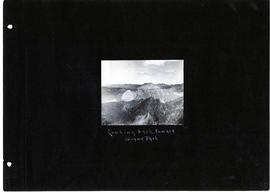
Mountaineers Scrapbook, 1912 to 1916, p. 27
Part of The Tacoma Mountaineers Records
The Mountaineers Summer Outing, July 20, 1912-August 10, 1913 Scrapbook, pg. 27. From captions, clockwise: Looking back toward Grand Park
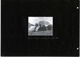
Mountaineers Scrapbook, 1912 to 1916, p. 28
Part of The Tacoma Mountaineers Records
The Mountaineers Summer Outing, July 20, 1912-August 10, 1913 Scrapbook, pg. 29. From captions, clockwise: Willis Wall at Sluiskin Mountains
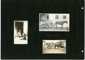
Mountaineers Scrapbook, 1912 to 1916, p. 34
Part of The Tacoma Mountaineers Records
The Mountaineers Summer Outing, July 20, 1912-August 10, 1913 Scrapbook, pg. 34. From captions, clockwise: Fairfax
Mountaineers Scrapbook, 1912 to 1916, p. 36
Part of The Tacoma Mountaineers Records
The Mountaineers Summer Outing, July 20, 1912-August 10, 1913 Scrapbook, pg. 36. From captions, clockwise: Home
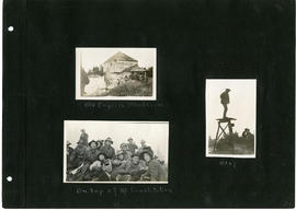
Mountaineers Scrapbook, 1912 to 1916, p. 39
Part of The Tacoma Mountaineers Records
The Mountaineers Summer Outing, July 20, 1912-August 10, 1913 Scrapbook, pg. 39. From captions, clockwise: Old English Blockhouse, Otey, On top of Mt. Constitution
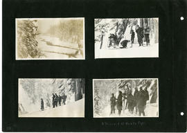
Mountaineers Scrapbook, 1912 to 1916, p. 50
Part of The Tacoma Mountaineers Records
The Mountaineers Summer Outing, July 20, 1912-August 10, 1913 Scrapbook, pg. 50. From captions, clockwise: Blizzard at Narada Falls
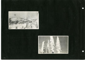
Mountaineers Scrapbook, 1912 to 1916, p. 52
Part of The Tacoma Mountaineers Records
The Mountaineers Summer Outing, July 20, 1912-August 10, 1913 Scrapbook, pg. 52. From captions, clockwise:
Mountaineers Scrapbook, 1912 to 1916, p. 53
Part of The Tacoma Mountaineers Records
The Mountaineers Summer Outing, July 20, 1912-August 10, 1913 Scrapbook, pg. 53. From captions, clockwise: Coley, Haze
Mountaineers Scrapbook, 1912 to 1916, p. 54
Part of The Tacoma Mountaineers Records
The Mountaineers Summer Outing, July 20, 1912-August 10, 1913 Scrapbook, pg. 54. From captions, clockwise: Pa, Ma and the Child
Mountaineers Scrapbook, 1912 to 1916, p. 65
Part of The Tacoma Mountaineers Records
The Mountaineers Summer Outing, July 20, 1912-August 10, 1913 Scrapbook, pg. 65. From captions, clockwise: Farewell La Grande
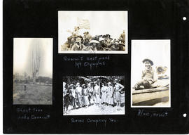
Mountaineers Scrapbook, 1912 to 1916, p. 82
Part of The Tacoma Mountaineers Records
The Mountaineers Summer Outing, July 20, 1912-August 10, 1913 Scrapbook, pg. 82. From captions, clockwise: Summit east peak Mount Olympus. Alec, mascot. Some company Ten. Ghost tree, Lake Quinault.
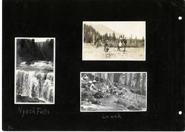
Mountaineers Scrapbook, 1912 to 1916, p. 86
Part of The Tacoma Mountaineers Records
The Mountaineers Summer Outing, July 20, 1912-August 10, 1913 Scrapbook, pg. 86. From captions, clockwise: Lunch, Nyack Falls
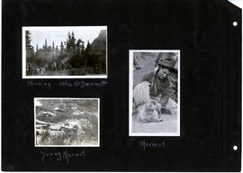
Mountaineers Scrapbook, 1912 to 1916, p. 88
Part of The Tacoma Mountaineers Records
The Mountaineers Summer Outing, July 20, 1912-August 10, 1913 Scrapbook, pg. 88. From captions, clockwise: Morning - Lake McDermott, Marmot, Young Marmot.
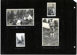
Mountaineers Scrapbook, 1912 to 1916, p. 90
Part of The Tacoma Mountaineers Records
The Mountaineers Summer Outing, July 20, 1912-August 10, 1913 Scrapbook, pg. 90. From captions, clockwise: Lame Duck Camp, Lake Sue, Bennett, our Leader, porcupine.
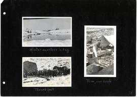
Mountaineers Scrapbook, 1912 to 1916, p. 91
Part of The Tacoma Mountaineers Records
The Mountaineers Summer Outing, July 20, 1912-August 10, 1913 Scrapbook, pg. 91. From captions, clockwise: Winter quarters in August, Tom, our cook, Breakfast
Mountaineers Scrapbook, 1912 to 1916, p. 94
Part of The Tacoma Mountaineers Records
The Mountaineers Summer Outing, July 20, 1912-August 10, 1913 Scrapbook, pg. 94.
Mountaineers Scrapbook, 1912 to 1916, p. 95
Part of The Tacoma Mountaineers Records
The Mountaineers Summer Outing, July 20, 1912-August 10, 1913 Scrapbook, pg. 95.
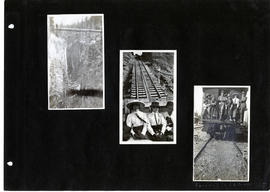
Mountaineers Scrapbook, 1912 to 1916, p. 97
Part of The Tacoma Mountaineers Records
The Mountaineers Summer Outing, July 20, 1912-August 10, 1913 Scrapbook, pg. 97.
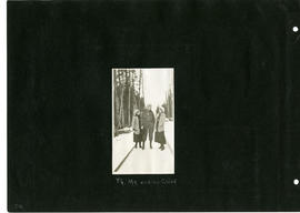
Mountaineers Scrapbook, 1912 to 1916, p. 100
Part of The Tacoma Mountaineers Records
The Mountaineers Summer Outing, July 20, 1912-August 10, 1913 Scrapbook, pg. 100.
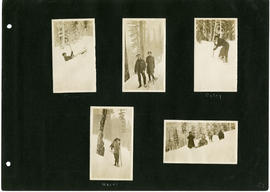
Mountaineers Scrapbook, 1912 to 1916, p. 105
Part of The Tacoma Mountaineers Records
The Mountaineers Summer Outing, July 20, 1912-August 10, 1913 Scrapbook, pg. 105.