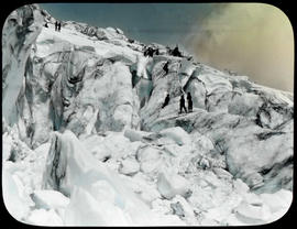
Several Mountaineers use a lifeline to work their way up a section of a glacier next to a crevasse. This photograph was taken during the Mountaineer outing to Mount Baker in 1908.
Mount Baker National Forest (Wash.); Mountaineering--Washington--1900-1910; Snow & ice climbing; Glaciers;
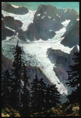
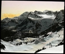
Mt. Baker trip - Overhanging glacier on Shuksan - on eastern side. On August 3, 1906, as a side trip from the Mazama outing to Mount Baker, W. Montelius Price and Asahel Curtis made the first recorded ascent of Mount Shuksan. Curtis used this photograph in his article in the July/August 1907 issue of Overland Monthly. The photograph was captioned "Beaufiful hanging glacies of Mt. Shuksan."
Mount Baker National Forest (Wash.); Shuksan, Mount (Wash.); Glaciers; Mountains--Washington--1900-1910;
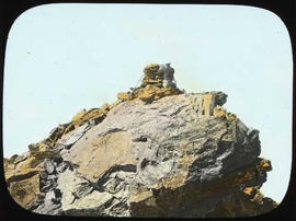
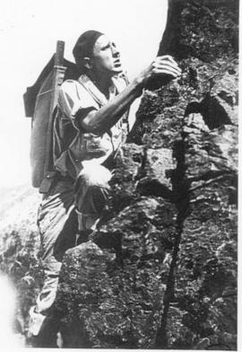
Mt. Baker trip - Price building monument on Shuksan - summit Mt. Shuksan. The climb by Asahel Curtis and W.M. Price was so difficult that they had to spend the night of August 3, 1906 on the mountain. This photograph shows W. M. Price building a cairn at the top of Mount Shuksan to commemorate their climb.
Mount Baker National Forest (Wash.); Shuksan, Mount (Wash.); Price, W. Montelius; Mountaineering--Washington--1900-1910; Cairns;
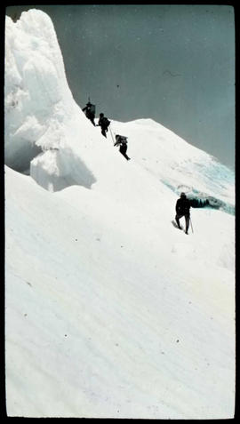
Part of the Mt. Baker series. Climbers are nearing the summit of Mt. Baker in July of 1908.
Mount Baker National Forest (Wash.); Baker, Mount (Wash.); Snow & ice climbing; Mountaineering--Washington--1900-1910; Mountains--Washington--1900-1910;
The steepness of the snow slope is obvious in this photographed dated July 20, 1908 of the climb on Mt. Baker. Part of the Asahel Curtis Mt. Baker series.
Snow & ice climbing; Baker, Mount (Wash.); Mountains--Washington--1900-1910;
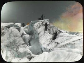
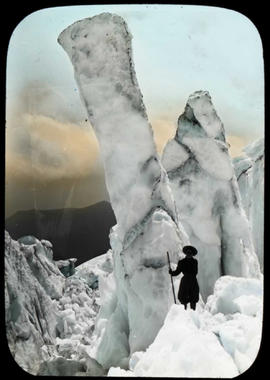
On July 20, 1908, a sole mountaineer gazed upon the enormous ice forms on Mount Baker. These towers of ice remained in a glacier's crevasse. Part of the Mt. Baker series.
Seracs; Baker, Mount (Wash.); Mountains--Washington--1900-1910; Glaciers; Mountaineering--Washington--1900-1910;
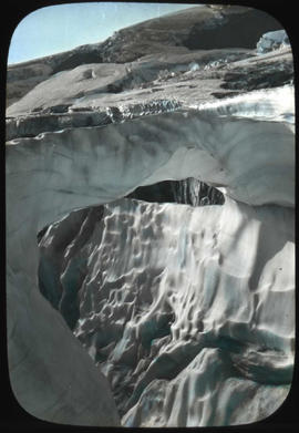
A snow bridge on the Mazama Glacier, Mt. Baker. This photograph was taken during the Mazama outing to Mount Baker in 1906. It was used by Asahel Curtis in his article for the April 1907 issue of Overland Monthly titled, "Mazama's Ascent of Mount Baker".
Mount Baker National Forest (Wash.); Glaciers; Baker, Mount (Wash.)
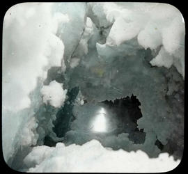
ca. 1906. "Looking Out" A photograph taken by Smith of an ice tunnel circa 1906. This photograph was part of a series of images taken on an outing up the north fork of the Tieton River in the Snoqualmie National Forest. It was probably taken on one of the glaciers in the Goat Rocks Wilderness area.
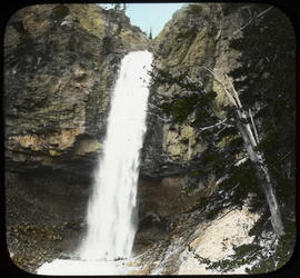
ca. 1906. The caption on the lantern slide from which this image was taken stated: "The Great Falls of the Tieton River." This falls is probably on the south fork of the Tieton River somewhere in the Snoqualmie National Forest.
Water falls; Snoqualmie National Forest (Wash.); North Fork Tieton River (Yakima County)
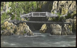
Mouth of Goblin Cave - Olympic Mountains. Probably taken by Grant Humes, this lantern slide shows Goblin Cave (or Goblin Canyon). Now known as Rica Canyon, the Elwha River goes through a narrow canyon as it flows north from the Geyser Basin. This photogaph shows two bridges that spanned the mouth of the canyon in 1907. The name Goblin Canyon dates from the Press Expedition.
Bridges--Washington--1900-1910; Elwha River (Wash.); Rica Canyon (Wash.); Canyons--Washington--1900-1910
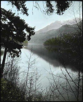
ca. 1909. This peaceful lake is either Lake Sutherland or Lake Crescent as seen circa 1909. Both lakes are close by with Lake Sutherland just to the east of Lake Crescent. Lake Crescent, however, is contained within the Olympic National Park while Lake Sutherland is just outside the boundaries of the park and is on private land.
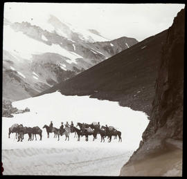
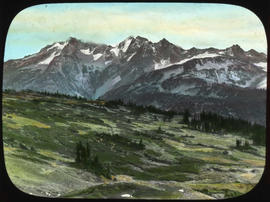
ca. 1906. A expedition of eight mountaineers on horse back, with seven pack horses, rest somewhere near the head of the south fork of the Tieton River, circa 1906. The label on the lantern slide from with this image was taken identified it as: "Goat Peaks and Pass - 7,000 ft. - Head of Tieton". "Goat Rocks" was another name for Mount Curtis Gilbert. The South Fork Tieton River has its source at Meade Glacier on Mt. Curtis Gilbert.
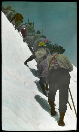
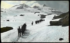
A group from the 1908 outing of the Mountaineers hike across a snow field on Mount Baker.
Mount Baker National Forest (Wash.); Mountaineering--Washington--1900-1910; Snow & ice climbing; Mountains--Washington--1900-1910; Baker, Mount (Wash.);
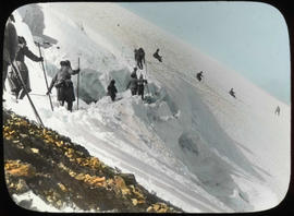
Life line work on Boulder Glacier - Mt. Baker. Mountaineers work together to enable climbers to ascend Boulder Glacier in this July of 1908 photograph. Part of the Mt. Baker series.
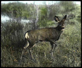
ca. 1910. A young deer pauses, one foot in the air, among the tall grass in Okanogan County, circa 1910. This photograph appears on page 25 in the book "Frank Matsura, Frontier Photographer, " by JoAnn Roe.
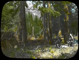
May 27, 1907 - Crackerville/Camp Godkin - Olympics This lantern slide reproduces a photograph by Asahel Curtis that was taken in spring of 1907 when he, W.M. Price, and Grant Humes hiked down the Elwha River to plan the 1907 Mountaineers Outing. Two men sit on the ground in a camp that is identified by Curtis as Crackerville or Camp Godkin. Camp Godkin, now known as Camp Wilder, is just north of the point where the Godkin flows into the Elwha. The men in the picture are probably W. M. Price and Grant Humes.
Undated photograph of a man silhouetted against the pale sky while atop the cliff at Priest Rapids, a narrow, fast-moving section of the Columbia River. A photographer by the name of Smith captured this striking view.