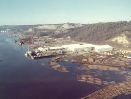
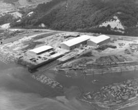
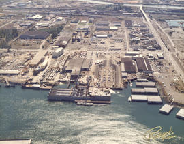
1973 Richards stock footage. Aerial view of shipyard believed to be Tacoma Boatbuilding Co. taken on a clear February day in 1973. Masses of logs float nearby until needed. The shipyard faces the Hylebos Waterway and was moved there after Tacoma Boatbuilding's longtime plant on the Sitcum Waterway was destroyed by fire in 1968.
Aerial views; Boat & ship industry--Tacoma--1970-1980; Tacoma Boat Building Co., Inc. (Tacoma); Logs; Hylebos Waterway (Tacoma);
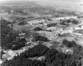
Aerial view looking northwest of the 112th & Meridian area in April of 1973. 112th St. runs diagonally past the Willows Mobile Home Park. At the far right center, according to a reader, was the brand new Willows Shopping Center with Piggly Wiggly and a Pay-N-Save. Just below the center of the photograph was the intersection of 116th St. E. and Meridian. The newer L-shaped building south of the trailer park was another shopping center, later home to MegaFoods, and presently a redeveloped shopping center containing Best Buy. Photograph ordered by Collison Realty. (Additional information provided by a reader)
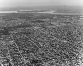
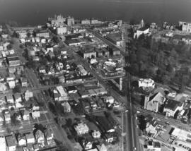
Looking west from South 56th & Pacific Ave. Aerial view on April 2, 1973, of the densely populated area around the Tacoma Mall. The Mall itself is right-center. Olympics are at the top of the photograph. Photograph ordered by Puget Sound National Bank.
Aerial views; Neighborhoods--Tacoma--1970-1980; Tacoma Mall Shopping Center (Tacoma); Shopping centers--Tacoma--1970-1980;
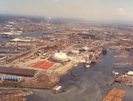
ca. 1973. 1973 Richards stock footage. This aerial view features the two large domes leased by Kaiser Aluminum from the Port of Tacoma. The aluminum sheathed domes stored shipments of alumina ore from Australia. Both domes were eventually dismantled about 2005.
Aerial views; Storage tanks--Tacoma; Kaiser Aluminum & Chemical Corp. (Tacoma); Port of Tacoma (Tacoma);
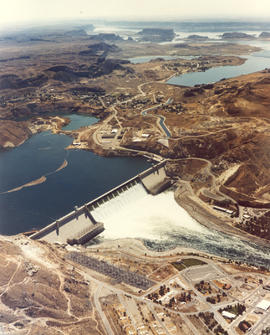
Undated color copy of photograph from the 1973 Richards stock footage. Aerial view of the Grand Coulee Dam and surrounding area. The dam is in the center with Lake Roosevelt behind. The Grand Coulee is a large hydroelectric dam located on the Columbia River.
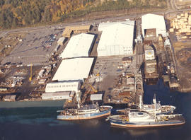
ca. 1973. Copy of customer print ordered on April 5, 1973, by Tacoma Boatbuilding. Colorful aerial view of Tacoma Boatbuilding's 20-acre plant on the Hylebos Waterway. Three cargo ships, including the "Atlantis," are in port. Tacoma Boatbuilding had moved to 1840 Marine View Dr. N.E. in 1969 after fire had destroyed their longtime Sitcum Waterway plant.
Aerial views; Tacoma Boat Building Co., Inc. (Tacoma); Boat & ship industry--Tacoma--1970-1980; Cargo ships--Tacoma; Hylebos Waterway (Tacoma);
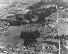
The landscape above has probably changed in the 30+ years since this Richards Studio photograph was taken. More homes have probably been built and traffic, barely seen above, increased. This aerial is possibly in the North Puyallup section of the county. Photograph ordered by Puget Sound National Bank.
Aerial color view of Tacoma's industrial Tideflats area in the summer of 1974, taken on behalf of Pan Pacific Trading Co., log exporters. This particular business, with plenty of empty land surrounding it, has not been positively identified. Mount Rainier in background with snowy tip emerging from cloud cover.
Aerial views; Industrial facilities--Tacoma--1970-1980; Rainier, Mount (Wash.);
ca. 1969. This "artistically modified" view of downtown Tacoma was created for the Downtown Tacoma Association in 1969. Along with the Bank of Washington building at 1201-23 Pacific Avenue, it shows a second high-rise building in the 1100 block of Pacific and numerous parking structures on Market and on the south end of Broadway. The building at the corner of 11th and pacific is at least twice the height of the Pacific First Federal building that was built on that site. Only the Washington Plaza (now Wells Fargo Plaza), which was completed in January of 1971, was built more or less as visualized.
Aerial views; National Bank of Washington (Tacoma); City Waterway (Tacoma); Commercial streets--Tacoma--1960-1970;
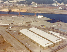
Aerial view of new Tacoma Boatbuilding plant and log dumps on the Hylebos Waterway. The new facility would replace the longtime plant on the Sitcum Waterway which had been gutted by fire in 1968. The L-shaped structrure nearest to Marine View Dr. roadway is believed to hold the administrative and engineering offices. The largest building in this October 4, 1969, photograph is the aluminum fabricating plant, flanked by the steel fabricating building. The building nearest the water is the trades building which holds the equipment used by pipefitters and electricians. A 300-foot pier is being constructed next to 350-foot double ways. With 20 acres of land, the plant had plenty of room for further expansion if needed. Photograph ordered by Tacoma Boatbuilding. (TNT full page ad 10-10-69, A-20; TNT 10-19-69, D-10)
Aerial views; Boat & ship industry--Tacoma--1960-1970; Tacoma Boat Building Co., Inc. (Tacoma); Logs; Hylebos Waterway (Tacoma);
County-City Building. Aerial view looking south on Tacoma Ave. So. with close-up of side and rear of County-City Building, its large parking lot, and Tacoma Public Library across the street. The County-City Building had been completed in 1959 to replace the venerable Old City Hall, 625 Commerce St. Ten years later it housed both city and county offices, including the health department, auditor, assessor, sheriff and city police, city council & mayor, county commissioners and courts. The future would see many of these departments move to separate buildings including the Municipal Building (formerly the Medical Arts Building), Pierce County Annex and the new Tacoma Police Department's complex on Pine St. Photograph ordered by Whitacre Engineers.
Aerial views; County-City Building (Tacoma); Tacoma Public Library (Tacoma); Public libraries--Tacoma--1960-1970; Parking lots--Tacoma--1960-1970; Commercial streets--Tacoma--1960-1970;
Aerial view of County-City Building and vicinity on a clear early October day in 1969. The County-City Building had celebrated its 10th birthday in 1969, having replaced the dilapidated Old City Hall on Commerce. It is the multi-story aluminum and glass building on Tacoma Ave. So. in the center of the photograph; one of its wings visible is the reinforced concrete court building. To the south of the County-City Building is the Tacoma Public Library; the Carnegie Library, now home to the library's Northwest Room & Special Collections, is the rounded Renaissance-styled structure. West of the County-City Building is the Washington National Guard Armory at 11th & Yakima; across the street from the Armory is the (now) L.H. Bates Vocational-Technical Institute. This view looks much the same now in 2006 as it did 37 years ago. Photograph ordered by Whitacre Engineers. TPL-9648
Aerial views; County-City Building (Tacoma); Tacoma Public Library (Tacoma); Public libraries--Tacoma--1960-1970; Tacoma Vocational School (Tacoma); State Armory (Tacoma); Commercial streets--Tacoma--1960-1970;
Aerial view looking north toward Commencement Bay on February 20, 1970. Wright Park is the wooded area at the left; First Presbyterian Church is Romanesque structure at 20 Tacoma Ave. So. The Vista Manor Apartments are located in the white 16-story building upper center. Near the Vista Manor is the Central Lutheran Church. ASARCO smokestack is near left corner. Stadium High School and Washington State Historical Society building overlooking the bay on the right. Photograph ordered by Puget Sound National Bank.
Aerial views; Neighborhoods--Tacoma--1970-1980; Wright Park (Tacoma); Commencement Bay (Wash.); Stadium High School (Tacoma); First Presbyterian Church (Tacoma); Stadium High School (Tacoma); Vista Manor Apartments (Tacoma);
Aerial look at the Stadium District featuring Division and 1st-3rd Streets in February of 1970. Division is the street heading in a northeast direction with Wright Park on the right. The First Church of Christ, Scientist, is at the corner of Division and "I, " across the street from the park. The dome of the First Presbyterian Church can be spotted near the top of the photograph; it is located at Tacoma Avenue So. and Division. The three streets running diagonally are 3rd, 2nd and 1st (l-r). Walker Chevrolet is the large dealership in the 600 block of Division, in the wedge shaped property. Stadium High School and Stadium Bowl are upper left center overlooking Commencement Bay. Photograph ordered by Puget Sound National Bank.
Aerial views; Neighborhoods--Tacoma--1970-1980; Wright Park (Tacoma); First Church of Christ, Scientist (Tacoma); First Presbyterian Church (Tacoma); Stadium High School (Tacoma); Stadium Bowl (Tacoma); Walker Chevrolet Co. (Tacoma);
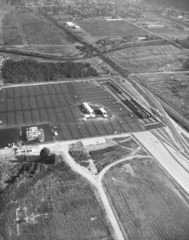
New automobile unloading complex. September, 1969, aerial view of a portion of the new Milwaukee Road Union Pacific yard in Kent designed by Tacoma architects and engineers, Siefert, Forbes & Berry. The multi-million dollar complex was scheduled for dedication on October 1, 1969. Easy access from the facility was provided by the Valley Freeway and 277th St. Photograph ordered by the Milwaukee Road. (TNT 10-1-69, A-17)
Aerial view of new automobile unloading complex. The Milwaukee and Union Pacific were scheduled to dedicate a multi-million dollar automobile unloading complex near Kent on October 1, 1969. Highway upper portion is the Valley Freeway; road that is diagonal is 277th St. Only one of the unloading facilities is in view in the paved section. Photograph ordered by the Milwaukee Road. (TNT 10-1-69, A-17)
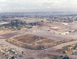
Aerial view of Tacoma Mall Shopping Center and Tacoma Mall Office Building. This July, 1969, view of the popular Tacoma Mall Shopping Center and newly opened six-story Tacoma Mall Office Building shows that there is still much room for development of the center. New stores would be built on both sides of the Bon Marche (red building), first occupant of the mall. The dirt acreage bordering the parking lot would eventually become extended parking for the mall and the location of Frederick & Nelson's. The Post Office would build its Evergreen Station also on Pine Street, just beyond the left edge of the photograph. Color photograph ordered by Center Offices, Inc.
Aerial views; Tacoma Mall Shopping Center (Tacoma); Shopping centers--Tacoma; Tacoma Mall Office Building (Tacoma); Parking lots--Tacoma--1960-1970; Bon Marche (Tacoma);
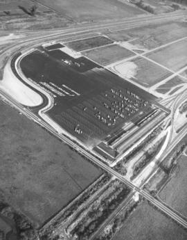
Automobile unloading facility. This is believed to be the Milwaukee Road Union Pacific yard in Kent recently dedicated in October of 1969. Cars were brought in by rail and due to the close proximity of the Valley Freeway and 277th St., easily transported elsewhere. They would roll down the ramps and could be parked, when necessary, in the yard's enormous parking lot. Aerial view of complex taken in April of 1970.
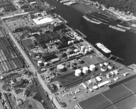
Aerial view on May 26, 1970, of the Tacoma industrial Tideflats, featuring Hooker Chemical and Hylebos Waterway. By 1970, Hooker had been in Tacoma for 41 years. It had begun in 1929 with production of 13 tons of chlorine a day and a work crew of 40. In 1969, production had increased to 400 tons with the aid of 300 employees. Hooker was the first to produce caustic soda. Chlorine and caustic soda were sold mostly to the pulp/paper industry in the Pacific Northwest. By 1969, Hooker Chemical was a wholly owned subsidiary of Occidental Petroleum. (TNT 2-2-69, B-8 -article) Photograph ordered by Hylebos Industries, Inc.
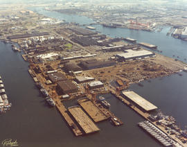
1976 Richards color stock footage. Overall aerial view of the bustling Port of Tacoma in October of 1976. Numerous ships are in port ready to load and unload cargo.
Aerial photographs; Aerial views; Cargo ships--Tacoma--1970-1980; Shipping--Tacoma--1970-1980; Port of Tacoma (Tacoma);
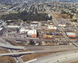
ca. 1976. Aerial view of longtime Tacoma foundry, Atlas Foundry & Machine Co., taken in the spring or summer of 1976. The company was founded in 1899 and began making iron castings for the Northwest logging industry. After the foundry was purchased by the Long family 30 years later, it began making steel as well as iron. By the 1930's, half of the firm's production was steel castings. Atlas is still in business in the 21st century; it is now known as Atlas Castings & Technology. This aerial photograph of the foundry in 1976 shows the city and roadways have grown in the 77 years since Atlas was founded. Atlas is bordered by Wilkeson (the long street extending vertically on the right) and South Tacoma Way (bottom) with Center St. on top. Stanley Elementary School is at the end of Wilkeson (top of photograph). I-5 freeway is on the bottom of photograph with the exits to So. 38th St. and Hwy 16 above. At the left corner of picture is the 25th St. bridge and Sprague Ave. (www.atlascastings.com)
ca. 1975. 1975 Richards color stock footage. Closer aerial view of what is believed to be Concrete Technology Corp., 1123 Port of Tacoma Rd., on the Tacoma tideflats. This photograph was possibly taken in the summer of 1975. Concrete Technology dealt in prestressed and precast concrete. Waterway shown is believed to be the Blair Waterway (formerly Port Industrial Waterway).
ca. 1975. 1975 Richards color stock footage. Aerial view of industrial facility on Tacoma's tideflats. This is believed to be Concrete Technology's plant on Port of Tacoma Rd. Waterway is believed to be the Blair (formerly Port Industrial) Waterway.
1976 Richards color stock footage. October, 1976, aerial view of Tacoma tideflats including various industrial facilities. This unidentified plant is believed to be along the Blair Waterway .
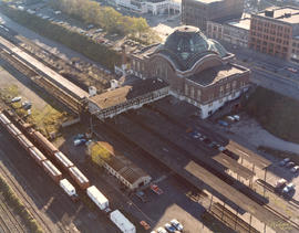
ca. 1975. 1975 Richards color stock footage. Rear view of Union Station. Located on lower Pacific Avenue, Union Station was built in 1911 by the Hurley-Mason Co. Although the station is still there some thirty years after this 1975 aerial photograph was taken, its surroundings are quite different. SR-705 would be built to run behind the station and the last train would leave Union Station in June of 1984. The Washington State History Museum is now on the site of the former tree-lined parking lot while the Federal Courts are now located in a new wing north of Union Station. Plans to construct a shopping center/transportation complex including Union Station were shelved after many years of trying. TPL-2399
Aerial views; Aerial photographs; Union Station (Tacoma); Railroad stations--Tacoma--1970-1980; Railroad tracks--Tacoma--1970-1980;
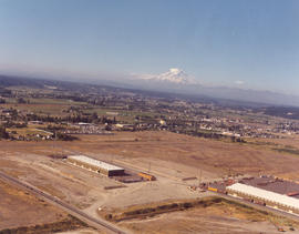
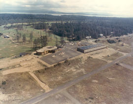
Aerial view of unidentified buildings. Construction may not yet be completed at this unidentified site near a heavily wooded area. There is a large section of cleared land near the two-lane roadways which may later be used for either homes or businesses. Color photograph ordered by Pacific Lanes.
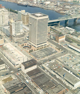
ca. 1971. 1971 color Richards stock footage. Aerial view of downtown commercial district featuring a mixture of new construction and older buildings. The first highrise built in downtown Tacoma in 40 years, the Pacific National Bank of Washington Plaza, at 24-stories, towered over its banking neighbors, Puget Sound National Bank and Seattle-First National Bank. Adding to new construction on Pacific Avenue was the Park Plaza South parking garage, which provided much needed parking stalls for shoppers and workers. They joined older buildings including Peoples department store, Washington Building, Tacoma Building and slightly older Greyhound Bus Terminal, considered ultra-modern when constructed in 1958.
Aerial views; Pacific National Bank of Washington (Tacoma); Puget Sound National Bank (Tacoma); Banks--Tacoma; Peoples (Tacoma); Washington Building (Tacoma); Tacoma Building (Tacoma); Greyhound Bus Terminal (Tacoma); Parking garages--Tacoma--1970-1980;
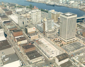
ca. 1971. 1971 color Richards stock footage. Aerial view taken on a clear day in 1971 of the downtown business district, featuring area impacted by urban renewal. New structures include the massive Bank of Washington Plaza with its 24-story tower (including helipad) and circular sunken fountain, and two new parking garages- Park Plaza South and North to aid in alleviating parking problems for shoppers and workers. This aerial photograph also shows the deep blue waters of the City (now Thea Foss) Waterway and a portion of the 11th Street Bridge (now Murray Morgan Bridge) that connects the city with the industrial Tideflats. Other notable structures include the Puget Sound National Bank with its spire; Peoples department store next door; the Rust and Washington Buildings, both with neon signs advertising other banks--American Federal Savings and Bank of California, respectively; Tacoma Building and Seattle-First National Bank (formerly Bank of Tacoma).
Aerial views; Pacific National Bank of Washington (Tacoma); Puget Sound National Bank (Tacoma); Banks--Tacoma; Rust Building (Tacoma); Washington Building (Tacoma); Tacoma Building (Tacoma); Parking garages--Tacoma--1970-1980; City Waterway (Tacoma);
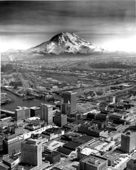
ca. 1971. Customer copy of downtown Tacoma landscape taken from the air, circa 1971. Snow-capped Mount Rainier looms in the background. Prominent buildings include the Art-Deco styled Medical Arts Building (now the Municipal Building) in lower left; Puget Sound National Bank with its distinctive spire; the 22+ story Bank of Washington Plaza building, the Washington Building with the neon Bank of California sign on its root; and Schoenfelds furniture store.
Aerial views; Business districts--Tacoma--1970-1980; Rainier, Mount (Wash.); Medical Arts Building (Tacoma); Puget Sound National Bank (Tacoma); Washington Building (Tacoma); L. Schoenfeld & Sons (Tacoma); Pacific National Bank of Washington (Tacoma);
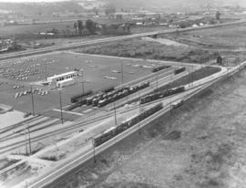
Aerial view of Kent-based Convoy Co. taken on May 1, 1972. Massive parking lot with hundreds of cars, easy access to major roadways. Railroad cars parked next to facility, many loaded with automobiles. Convoy Co. was located in Kent at 27430 - So. 72nd. Photograph ordered by the Convoy Co.