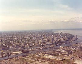
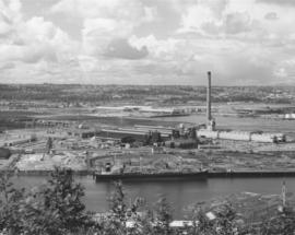
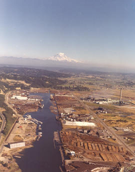
Aerial view of the City of Tacoma as seen from the industrial Tideflats. The City (now Thea Foss) Waterway separates the bustling industrial area from Tacoma's downtown business district. This May, 1974, photograph aptly captures how the ready availability of rail, water, and highway transport attracted such companies as Hooker Chemicals and St. Regis to Tacoma.
Aerial photographs; Aerial views; City Waterway (Tacoma); Business districts--Tacoma--1970-1980; Industrial facilities--Tacoma;
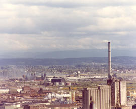
Kaiser Aluminum plant. This aerial view of the Kaiser Aluminum plant was taken on June 10, 1974. The plant was located in Tacoma's tideflats at 3400 Taylor Way. The wisps of smoke emerging from the plant's 500-foot stack appear to blend into the heavy cloud formation. Color photograph ordered by Kaiser Aluminum.
Aerial photographs; Kaiser Aluminum & Chemical Corp. (Tacoma); Industrial facilities--Tacoma--1970-1980; Aluminum industry--Tacoma--1970-1980;
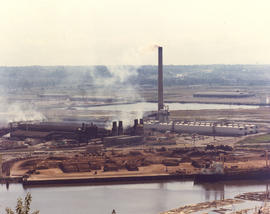
Aerial of Kaiser Aluminum plant as viewed on June 10, 1974. Smoke drifts from the 500-foot stack near the aluminum rod mill. 32 years later in July of 2006, the smokestack was demolished in front of hundreds of fascinated spectators. Color photograph ordered by Kaiser Aluminum.
Aerial photographs; Kaiser Aluminum & Chemical Corp. (Tacoma); Industrial facilities--Tacoma--1970-1980; Aluminum industry--Tacoma--1970-1980;
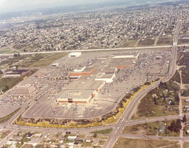
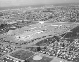
1974 Richards stock footage. A look at the Tacoma Mall by air in the spring of 1974 shows that the Mall continues to grow with the building of the new Liberty House/Rhodes department store at the Mall's extreme west end. The store was scheduled to open that fall. I-5 runs nearly vertically at the photograph's right, allowing easy access to the shopping center. The wooded area east of the freeway would eventually be dotted with new homes; businesses would also take the place of the homes located at the bottom of the photograph.
1974 Richards stock footage. Aerial view of the Tacoma Mall and surrounding south end neighborhoods. This May, 1974, view by air makes it plain that one of the main attributes of this popular shopping center was its ready access by freeway and its enormous free parking lots. Should a visitor to the Mall decide to bypass the freeway, the Mall would still be accessible through well traveled local streets such as Pine, South 38th and South 48th. The Mall had opened its west end addition in July of 1973 to add 20 more stores to the shopping center; in May of 1974, construction was proceeding rapidly with the new Liberty House/Rhodes department store at the far west end of the shopping center. TPL-5876
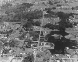
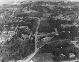
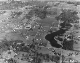
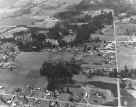
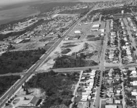
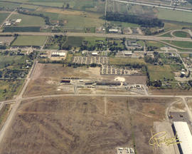
Aerial photographs of the area between 320th in Federal Way, North Puyallup, Pacific Highway South and Valley Ave. were taken on a clear day in late March, 1975. This particular view was not positively identified. Lot sizes appeared large and the area not densely occupied. There are two lakes/ponds visible. Photograph ordered by Puget Sound National Bank.
Puget Sound National Bank had requested aerial photographs of the land between 320th in Federal Way, North Puyallup, Pacific Highway South and Valley Ave. in late March of 1975. The area shown above is heavily wooded with small neighborhoods scattered among the trees.
On March 27, 1975, several aerial photographs were taken by the Richards Studio of the area between 320th in Federal Way, North Puyallup, Pacific Highway South and Valley Ave. for Puget Sound National Bank. Most of the series shown the abundance of wooded areas and undeveloped property with smaller neighborhoods scattered on the landscape. The aerials also noted the many roadways, including freeways, in the area.
A series of aerial photographs were taken on March 27, 1975, on behalf of Puget Sound National Bank of the area between 320th in Federal Way, North Puyallup, Pacific Highway South and Valley Ave. The purpose for the photographs was not expressed in Richard studio notes but it is possible that the bank was preparing for the later acquisition of banks in the vicinity.
A series of photographs were taken on March 27, 1975, on behalf of Puget Sound National Bank of the area between 320th in Federal Way, North Puyallup, Pacific Highway and Valley Ave. These aerial views of thirty years past show relatively undeveloped areas with little traffic.
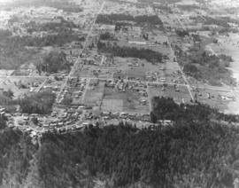
Aerial view, taken in March of 1975, of communities interspersed among large sections of firs. According to Richard Studio notes, the firm had been requested to take a series of photographs of the region between 320th in Federal Way, North Puyallup, Pacific Highway South and Valley Ave. for Puget Sound National Bank.
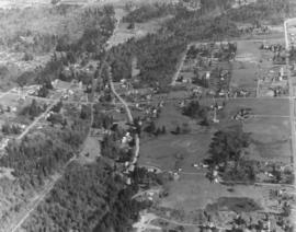
Aerial view of heavily wooded lands possibly in the North Puyallup/Valley Ave location. This view has undoubtedly changed in the 32 years since the photograph was taken on behalf of Puget Sound National Bank.
ca. 1974. This view of the Kaiser Aluminum plant is a cropped version of D165187, image A. It was taken circa 1974 with the focus on the 500-foot stack near right center. The stack was built in 1968, the same year Kaiser's new aluminum rod mill commenced operation.
Aerial views; Kaiser Aluminum & Chemical Corp. (Tacoma); Industrial facilities--Tacoma--1970-1980; Aluminum industry--Tacoma--1970-1980; Smokestacks--Tacoma;
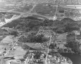
The landscape above has probably changed in the 30+ years since this Richards Studio photograph was taken. More homes have probably been built and traffic, barely seen above, increased. This aerial is possibly in the North Puyallup section of the county. Photograph ordered by Puget Sound National Bank.
Aerial color view of Tacoma's industrial Tideflats area in the summer of 1974, taken on behalf of Pan Pacific Trading Co., log exporters. This particular business, with plenty of empty land surrounding it, has not been positively identified. Mount Rainier in background with snowy tip emerging from cloud cover.
Aerial views; Industrial facilities--Tacoma--1970-1980; Rainier, Mount (Wash.);
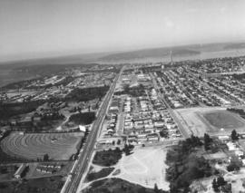
Closer look by air at Pearl St. in Tacoma's west end. Pearl St. is the street farthest left running vertically toward Point Defiance. Parallel to Pearl is Orchard St. with the playing fields of Wilson High School nearby. North 11th St. runs horizontally intersecting Orchard and Pearl. The Auto View Drive-In is to the left of Pearl. ASARCO's famous smokestack is clearly visible near the top of the photograph. Photograph ordered by Puget Sound National Bank.
Aerial views; Neighborhoods--Tacoma--1970-1980; Auto View Drive-In (Tacoma); Smokestacks--Tacoma;
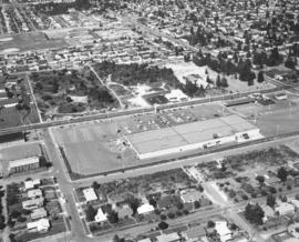
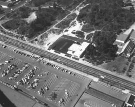
This section of Sixth Avenue looks a bit different now than it did in 1974. Kmart, with its 1000-car parking lot, is still there but the area directly across the street has been dotted with small shopping malls. In 1974 the only business immediately across Kmart was a new Goodyear store which would celebrate its grand opening at the tail end of October, 1974. The First Christian Church is set on a large wooded lot close to Goodyear. Wilson High School, 12th & Orchard, is the cluster of buildings near the top left center. Aerial photograph ordered by Puget Sound National Bank.
Aerial views; Neighborhoods--Tacoma--1970-1980; Kmart (Tacoma); Parking lots--Tacoma--1970-1980; Goodyear Service (Tacoma); First Christian Church (Tacoma); Woodrow Wilson High School (Tacoma);
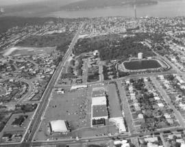
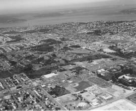
Aerial view of the Westgate neighborhood, taken via helicopter on August 28, 1974, on behalf of Puget Sound National Bank. Shopping center below is the Westgate Shopping Center at North 26th & Pearl St. The Westgate Thriftco (formerly known as Thriftway) was one of the main tenants. North 26th runs horizontally at bottom of the photograph; it intersects with Pearl Street on the left. Pearl is the extremely long street that will eventually end at Point Defiance Park. Other landmarks clearly visible include the North 30th St. reservoir and water tower at photo's right-center and ASARCO's smokestack at top.
Aerial views; Neighborhoods--Tacoma--1970-1980; Westgate Shopping Center (Tacoma); Reservoirs--Tacoma; Water towers--Tacoma; Thriftco (Tacoma); Smokestacks--Tacoma;
Westgate Shopping Center and environs via helicopter on August 28, 1974. The Westgate Shopping Center at North 26th & Pearl would later expand to include the large block across North 26th St. Most of the lot was undeveloped at the time of this 1974 photograph. Major streets on display are Pearl and Orchard St. (running vertically and parallel to one another) intersected by North 21st and North 26th. The North 30th St. water tower and reservoir is located at the upper right corner. Photograph ordered by Puget Sound National Bank.
Aerial views; Neighborhoods--Tacoma--1970-1980; Westgate Shopping Center (Tacoma); Water towers--Tacoma; Reservoirs--Tacoma;
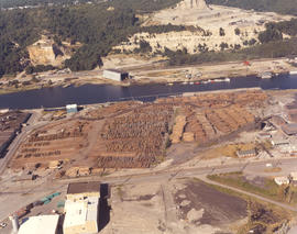
Log storage along the Hylebos Waterway. Pan Pacific Trading were log exporters with locations at 3502 Lincoln Ave and Yard 2 at 2407 Port of Tacoma Rd. This August, 1974, aerial shows the large Pan Pacific lot filled with stacks of logs. Color photograph ordered by Pan Pacific Trading Co.
Mount Rainier casts a benevolent eye on the industrial Tideflats in this color photograph taken on August 9, 1974. Kaiser Aluminum plant with 500-foot stack is on the right and Hylebos Waterway on the left. Piles of logs near bottom belong to Pan Pacific Trading Co., log exporters. Color photograph ordered by Pan Pacific Trading Co.
Aerial views; Pan Pacific Trading Co. (Tacoma); Logs; Lumber industry--Tacoma--1970-1980; Shipping--Tacoma--1970-1980; Kaiser Aluminum & Chemical Corp. (Tacoma); Rainier, Mount (Wash.); Hylebos Waterway (Tacoma);
ca. 1974. Aerial photograph of Kaiser Aluminum plant in industrial tideflats area of Tacoma, probably taken during the summer of 1974. The plant's 500-foot stack dominates the landscape. A ship is docked nearby taking on shipments of logs. Photograph ordered by Kaiser Aluminum.
Aerial views; Kaiser Aluminum & Chemical Corp. (Tacoma); Industrial facilities--Tacoma--1970-1980; Aluminum industry--Tacoma--1970-1980; Smokestacks--Tacoma; Logs; Shipping--Tacoma--1970-1980;
Aerial view of Tacoma's west end neighborhoods on August 28, 1974. Main streets shown above are Pearl (running toward Point Defiance) and Sixth Avenue (more diagonally). Hunt Junior High School (now Middle) with its mushroom-shaped cafeteria/auditorium is at the bottom of the photograph. On the left side of Sixth Ave. is the Highland Hill(s) shopping center with Ernst Hardware (white building) nearby. On the left of Pearl is the Auto View Drive-In at the center of the photograph. ASARCO's smokestack is near the top of the picture. Photograph ordered by Puget Sound National Bank.
Aerial views; Neighborhoods--Tacoma--1970-1980; Auto View Drive-In (Tacoma); Henry F. Hunt Junior High School (Tacoma); Highland Hills Shopping Center (Tacoma); Smokestacks--Tacoma;
Aerial view of Sixth Avenue close to Orchard St. This August 28, 1974, view by helicopter shows the enormous Kmart parking lot with room for 1000 cars. Directly across the street is the new Goodyear Service, 5131 Sixth Avenue, managed by Chuck Ackley. The First Christian Church, at Sixth & Orchard, is separated from the Goodyear store by a thick strand of firs. Smaller strip malls have since been erected on the wooded sites to the left and rear of the Goodyear store. Photograph ordered by Puget Sound National Bank.
Aerial views; Neighborhoods--Tacoma--1970-1980; Parking lots--Tacoma--1970-1980; Kmart (Tacoma); Goodyear Service (Tacoma); First Christian Church (Tacoma);
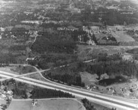
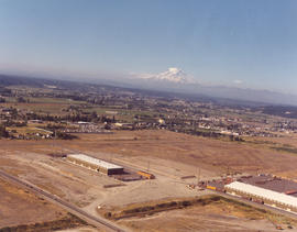
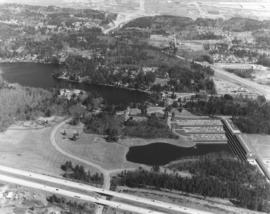
I-5, SR18 and Weyerhaeuser headquarters. The Richards Studio photograph took a series of photographs of the area between 320th in Federal Way, North Puyallup, Pacific Highway South and Valley Ave. on March 27, 1975, for Puget Sound National Bank. The I-5 freeway runs at the bottom of the photograph. State Route 18 is toward the top. This is also a closer view of the Weyerhaeuser Corporation's headquarters which were built in 1971 in Federal Way. Previously the company had been based in Tacoma. Weyerhaeuser would celebrate its 100th annivesary in January of 2000.
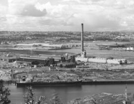
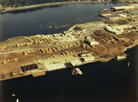
Copy of customer print. Aerial view of the Tacoma industrial tideflats in August of 1975 featuring the Hylebos Waterway at top and the Blair (formerly Port Industrial) Waterway below. There are numerous stacks of lumber in the yards between the two waterways. Color photograph ordered by Westrade, Inc.
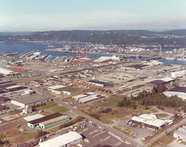
1976 Richards color stock footage. Aerial view in October of 1976 of the city's industrial tideflats and businesses bordering the Hylebos and Blair (formerly Port Industrial) Waterways. Bright orange cranes and large containers provide a splash of color amidst the industrial facilities.
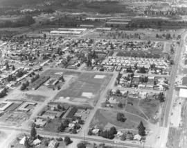
Aerial views of Lakewood neighborhoods near the Villa Plaza Shopping Center were taken on behalf of Newman Properties on June 1, 1976. This particular photograph captures the area around 47th Avenue and Lakeview Avenue. Lakeview is the street running vertically near the right side of picture; 47th borders the Lakeview Elementary School near the center. The cluster of large buildings near the top are part of the Naval Supply Depot which is now the Lakewood Industrial Park.
1975 Richards color stock footage. This aerial photograph is possibly of an automobile unloading facility in South King County. Rows of cars look like matchbox toys from this lofty distance. Cars could be easily transported via rail and highway.
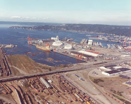
1976 Richards color stock footage of Commencement Bay and industrial tideflats. Aerial view featuring the Port of Tacoma's Kaiser Domes, extended Pier 7, cargo ships and railroad cars was taken on October 4, 1976. Ships were able to pull up next to Pier 7 and unload their shipments of ore to be stored in the two large domes. Railroad cars were in the immediate neighborhood for transporting products.