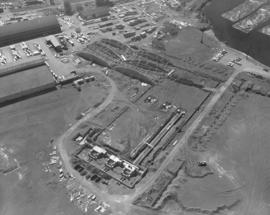
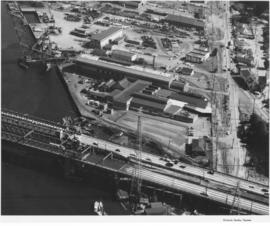
1964 stock footage. New construction at St. Regis Paper Co. St. Regis saw a major expansion and modernization project go into effect in 1964 with the building of a new stud mill, veneer mill, and new 15-acre dry-land log-handling yard. 35 acres of new land were created on the harbor for the new facilities when a saltwater log pond was filled in. Two giant stackers would classify and handle the logs received by truck, rail and water, accumulating an inventory in preparation for the stud and veneer mills. Both mills were expected to be in operation by April, 1965. (1964 St. Regis Annual Report, p. 20)
Aerial photographs; St. Regis Paper Co. (Tacoma)--1960-1970; Building construction--Tacoma--1960-1970;
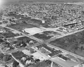
Stock footage of So. 19th & Union Ave. in Tacoma's northend. This June 23, 1964, aerial view shows the newly built Unionaire Apartments, 1902 So. Union Ave. The 46-unit complex was built by Lundstrom Bldg. Enterprises; units had Marblecrete exterior. The Allenmore Medical Center would be built the following year across the street from the Unionaire at 1901 So. Union.
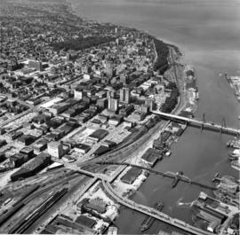
This aerial photographs of downtown Tacoma looking toward Point Defiance was taken on June 16, 1958. Prominent are the three bridges crossing the City (now Thea Foss) Waterway--the 11th St. Bridge, the Railroad Bridge and the 15th St. Bridge. Among a number of identifiable buildings are the massive Schoenfeld's furniture store with its enormous store lettering, the new County-City Building under construction toward the left corner of the photograph, the old County Courthouse behind it, the Washington Building and Puget Sound National Bank, for about two years the tallest building west of the Mississippi (until the Smith Tower was built in Seattle). Wright Park is the heavily wooded area to the right and above of the new County-City Building. Urban renewal had not yet replaced any of the buildings on Pacific Ave. with parking garages. TPL-8676
Aerial photographs; Bridges--Tacoma--1950-1960; County-City Building (Tacoma);
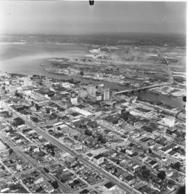
The neatly laid out streets of downtown Tacoma and a portion of the industrial Tideflats area were photographed by airplane on June 16, 1958. Tacoma had concentrated its main financial and business districts in the downtown area. The 11th St. Bridge, visible crossing the City (now Thea Foss) Waterway, extends into the Tideflats. Smoke billows from the various pulp and paper mills in this more sparsely inhabited area. The Tideflats was home to railroad, lumber, and shipbuilding interests.
Aerial photographs; Commercial streets--Tacoma--1950-1960; 11th Street Bridge (Tacoma);
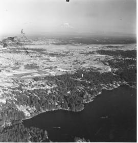
Aerial photographs of the Lakewood area were taken on August 5, 1958. Lake Steilacoom is the large body of water to the foreground. The Villa Plaza Shopping Center is easily spotted as it is surrounded by acres of paved parking lots. McChord Air Force Base, as the group of white buildings, can barely be seen near the right of the photograph. Only the tip of Mount Rainier is clearly visible as mist covers the lower portions. Photograph ordered by Richards Studio for a sample book.
Aerial photographs; Villa Plaza Shopping Center (Lakewood); Lake Steilacoom (Wash.);
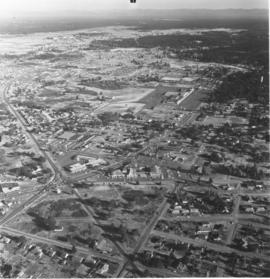
Aerial photographs of the Lakewood neighborhoods including Bridgeport and Gravelly Lake Drive were taken on August 2, 1958, by the Richards Studio for inclusion in a sample book. McChord Air Force Base are the white group of buildings near the top of the photograph. The new Villa Plaza Shopping Center is surrounded by a massive paved parking lot. The Lakewood Center, Lakewood's first shopping center constructed in 1937 and remodeled and expanded the early 1950's, is toward the center of the photograph. The Little Church on the Prairie is on Motor Drive, to the right of the Lakewood Center.
Aerial photographs; Villa Plaza Shopping Center (Lakewood); Lakewood Community Center (Lakewood); Shopping centers--Lakewood--1950-1960; Neighborhoods--Lakewood--1950-1960;
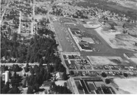
Villa Plaza Shopping Center as seen overhead by plane. Aerial photographs of the Villa Plaza Shopping Center in Lakewood were taken on August 5, 1958. Noticeable is the large parking lot with room for 4000 cars. At this time the Villa Plaza had approximately 30 stores including Rhodes, Grants, Penney's, Foreman & Clark and Thriftway supermarket. There appears to still have been room for further expansion to the right of the photograph. The heavily wooded section to the photograph's left may not be there nearly 50 years later; it is probably all housing. Photograph ordered by Dolph Jones.
Aerial photographs; Villa Plaza Shopping Center (Lakewood); Neighborhoods--Lakewood;
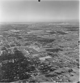
Views of suburban Lakewood were taken by plane on August 2, 1958, by Richards Studio for use in a sample book. The new Villa Plaza Shopping Center is toward the center of the picture on Gravelly Lake Drive. It is easy to pick out because of the large cluster of buildings surrounded by the huge parking lot. TPL-8320
Aerial photographs; Villa Plaza Shopping Center (Lakewood); Shopping centers--Lakewood--1950-1960; Neighborhoods--Lakewood--1950-1960;
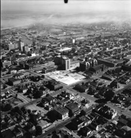
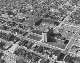
Aerial photographs taken on September 9, 1958, show the nearly completed County-City Building on Tacoma Avenue South. The parking lot and landscaping still need to be done. The old Courthouse to the rear of the new building would be the last to be demolished. The land there, too, would become necessary parking. The State Armory, directly behind the Courthouse at 715 South 11th St., still remains. The Tacoma Public Library can be seen to the new County-City Building's right, at 1102 Tacoma Avenue South. Other prominent features include the Schoenfeld's furniture store and Union Station on Pacific Avenue and a portion of the City (now Thea Foss) Waterway. This view, looking southeast, was very similar to A116584-2. Hazy smoke or clouds nearly obliterate Mount Rainier in the distance as well as parts of the industrial Tideflats.
Aerial photographs; Aerial views; County-City Building (Tacoma); Pierce County Courthouse (Tacoma); State Armory (Tacoma); Tacoma Public Library (Tacoma); Streets--Tacoma--1950-1960; Commercial streets--Tacoma--1950-1960;
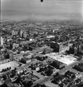
Aerial photographs taken on September 9, 1958, show the nearly completed County-City Building on Tacoma Avenue South. The parking lot and landscaping still need to be done. The old Courthouse to the rear of the new building would be the last to be demolished. The land there, too, would become necessary parking. The Tacoma Public Library can be seen to the new building's right. Other prominent features include the Schoenfeld's furniture store and Union Station on Pacific Avenue and a portion of the City (now Thea Foss) Waterway. This aerial view was taken looking southeast toward the industrial Tideflats and a hazy Mount Rainier.
Aerial photographs; County-City Building (Tacoma); Pierce County Courthouse (Tacoma); Tacoma Public Library (Tacoma); City Waterway (Tacoma); Rainier, Mount (Wash.);
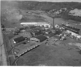
Aerial photographs of the Pennsylvania Salt Manufacturing Co. of Washington were taken on September 22, 1958. The Tacoma plant covered nearly 40 acres of land in the Tideflats near the Hylebos Waterway. It had easy access to motor and rail transportation as well as water routes. Despite its name, the firm did not manufacture table salt but was a thriving chemical concern, initially focusing on pulp and paper customers. TPL-6577
Aerial photographs; Pennsylvania Salt Manufacturing Co. of Washington (Tacoma); Chemical industry--Tacoma--1950-1960; Industrial facilities--Tacoma--1950-1960;
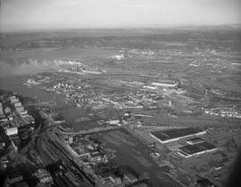
This is an aerial view of downtown Tacoma, City Waterway (now the Thea Foss Waterway) and industrial tideflats taken in December of 1961. Various bridges, including the 11th St. (now Murray Morgan Bridge) bridge, connect downtown to the mills and manufacturing concerns across the waterway. Plumes of smoke from St. Regis Paper Co. travel continuously across the bay as the plant ran multiple shifts. (scan from original negative, no print on file)
Aerial photographs; Aerial views; Cityscapes; Bridges--Tacoma--1960-1970; City Waterway (Tacoma); St. Regis Paper Co. (Tacoma)--1960-1970;
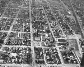
ca. 1962. Aerial photography of So. 11th & Tacoma Ave. So. vicinity taken in 1962; stock footage. Large building with wings in center of photograph is the County-City Building which had opened just a few years previously. Directly across the street is the Main Library and the older Carnegie section. A large parking lot separates the County-City Building from the State Armory. The Tacoma Vocational Technical Institute (Bates) is at So. 11th & Yakima. Neighborhood toward upper portion of the picture is the Hilltop area.
Aerial photographs; County-City Building (Tacoma); Tacoma Public Library (Tacoma); State Armory (Tacoma); Tacoma Vocational School (Tacoma);
ca. 1962. Copy of customer print. Aerial photograph of Tacoma's northend, specifically the University of Puget Sound campus, ca. 1962. This copy has been retouched; dark rectangular and square shapes seem to indicate where new construction will be occurring on the campus. The university planned to put in five new fraternity houses directly across the street from the campus and build two women's dorms to supplement Anderson and Harrington Halls. Photograph ordered by the North Pacific Bank Note Co.
Aerial photographs; University of Puget Sound (Tacoma)--1960-1970; Neighborhoods--Tacoma--1960-1970;
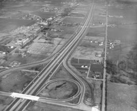
ca. 1963. Aerial photograph taken in 1963 of the Seattle-Tacoma Freeway going past Fife area. Circular portion is Port of Tacoma interchange. Old Hwy 99 is roadway on the left side of photograph. Fife Drive-In theater on Goldau Rd. is upper center, left of freeway. 20th St. E. is roadway on right side of freeway. TPL-9881
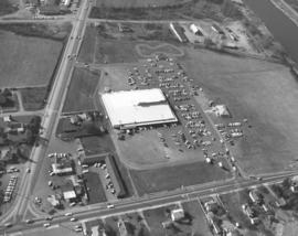
This aerial photograph from March 1963 shows the Hi-Ho Shopping Center located at the intersection of River Road (top to bottom) and North Meridian Street in Puyallup. The Puyallup River can be seen in the upper right corner. At this time the Hi-Ho Shopping Center was home to the Hi-Ho Food Center, the Hi-Ho Launder Center, and the Hi-Ho Shoe Center. In 1965 expansion brought a sporting goods store, a camera shop, a barber shop and a beauty parlor. The Hi-Ho Center was bought by Fred Meyer in 1980.
Aerial photographs; Hi-Ho Market (Puyallup); Shopping centers--Puyallup; Puyallup River (Wash.);
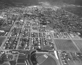
ca. 1963. Downtown Puyallup lies in the distance in this 1963 aerial photograph taken by the Richards Studio. This is a closer look at the area surrounding the Western Washington Fairgrounds. The edge of the enormous Grandstand is to the extreme left.
ca. 1963. Aerial photographs taken in 1963, looking west, of portions of Puyallup. The large building in the lower center of the photograph has been identified as Puyallup High School. To its right is the gym. Tennis courts are on the square to the left. Behind the main building is the science/library/arts building. Pioneer Ave. is to the left. To the right is Main St. which splits the school between the main building and the gym. (Additional information and identification provided by a reader)
Aerial photographs; Neighborhoods--Puyallup--1960-1970; Puyallup High School (Puyallup); Public schools--Puyallup; Streets--Puyallup;
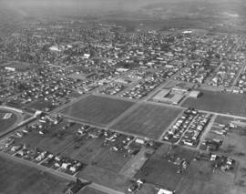
ca. 1963. Aerial 1963 photograph of the Puyallup region, featuring neighborhoods close to the Western Washington fairgrounds. Each year for seventeen days, the streets surrounding the Puyallup Fair are packed with cars and visitors. People have been coming to the fair since its beginning in 1900, eager to see animals of all kinds and crops grown in the Puyallup Valley's rich farmland.
Aerial photographs; Neighborhoods--Puyallup--1960-1970; Western Washington Fair (Puyallup);
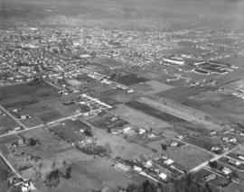
ca. 1963. 1963 aerial photographs of the Puyallup Valley. Puyallup River meanders at the upper portion of the photograph. Cluster of buildings to the upper right are the Western Washington Fairgrounds; the grandstand is particularly prominent. There was still plenty of open area in 1963; these would probably be filled up with homes in the future.
Aerial photographs; Neighborhoods--Puyallup--1960-1970; Western Washington Fair (Puyallup); Grandstands--Puyallup;
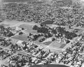
ca. 1963. The Proctor shopping area in 1963 looks much as it currently does in 2004 judging from this aerial photograph taken by the Richards Studio. Washington Elementary School on No. 26th St. is upper middle section; across the street is Tacoma Public Library's McCormick (now Wheelock) Branch. Safeway has a large grocery store a block away from the library. Mason Methodist Church is the large structure on No. 28th St. TPL-9198
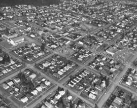
ca. 1963. 1963 aerial photographs taken by the Richards Studio of the city's northend neighborhoods show streets laid out neatly in a grid, looking northward toward the water. Jefferson Park, on the bottom of the photograph, at No. 9th had a large hitting park. The Cushman substation is toward the upper center portion of the photograph on No. 21st St. The wooded University of Puget Sound campus is to the right. The heavily treed area nearly reaching the water is Puget Park. TPL-9197
Aerial photographs; Neighborhoods--Tacoma--1960-1970; Jefferson Park (Tacoma);
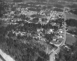
This is what the area surrounding Puget Park north of the Proctor District looked like by air in March of 1963. Proctor is the long street running vertically through the park; North 30th is the street running horizontally near the bottom. The houses in Tacoma's northend neighborhoods are clustered tightly together; many would have outstanding views of Commencement Bay. TPL-9696
Aerial photographs; Puget Park (Tacoma); Neighborhoods--Tacoma--1960-1970;
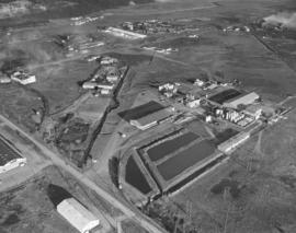
Aerial view of Reichhold Chemicals facilities taken on March 29, 1963. Located in the Tideflats industrial area, Reichhold Chemicals first established their plant on 51 acres on Lincoln Avenue in 1956. The Tacoma plant was the headquarters for the national company's Pacific Northwest Division. Reichhold's manufactured chemicals for Pacific Northwest industries, including the large plywood field. A railroad spur was built on company property that would ship products directly into Tacoma and beyond. By 1963, the company was listed in the City Directory at 2340 Taylor Way.
Aerial photographs; Reichhold Chemicals, Inc. (Tacoma); Chemical industry--Tacoma--1960-1970;
Aerial exposure of Bethlehem Pacific Coast Steel Co. in Seattle, industrial fastener division. Also known as the Bolt and Nut Department, this plant is located on a five acre tract along the Duwamish Waterway less than a mile east of the main plant. Here steel bars and rods are manufactured into bolts, nuts, spikes, rivets and a variety of fasteners.
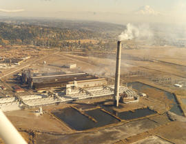
Smoke pours from the 500-foot smokestack at the Kaiser Aluminum plant, 3400 Taylor Way, on October 12, 1972. The company had undergone expansion in the late 1960s and built a new aluminum rod mill and second aluminum dome in addition to the smokestack. Kaiser Aluminum would permanently close in 2002 and the smokestack demolished four years later.
Aerial views; Kaiser Aluminum & Chemical Corp. (Tacoma); Aluminum industry--Tacoma--1970-1980; Smokestacks--Tacoma;
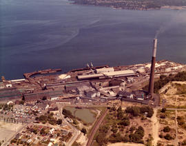
ca. 1973. 1973 Richards stock footage. An overhead view of the American Smelting & Refining Co. (ASARCO) and Commencement Bay in 1973. Wispy puffs of smoke emerge from the plant's 562-foot smokestack. ASARCO would eventually close twelve years later due to economic and environmental reasons. The smelter stack was demolished in 1993.
Aerial views; American Smelting & Refining Co. (Tacoma); Smelters--Tacoma--1970-1980; Smokestacks--Tacoma; Industrial facilities--Tacoma; Commencement Bay (Wash.);
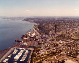
ca. 1973. 1973 Richards stock footage. Aerial view of North 52nd St. area, featuring the American Smelting & Refining Co. (ASARCO) plant and smokestack. Also in the photograph is winding Bayshore Drive near Commencement Bay. The tip of Mount Rainier can barely be seen in the background haze.
Aerial views; American Smelting & Refining Co. (Tacoma); Smokestacks--Tacoma; Commencement Bay (Wash.); Rainier, Mount (Wash.);