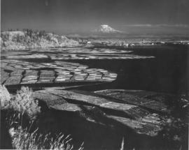
ca. 1943. Mount Rainier rises ghostlike above the Hylebos Waterway in this test photograph with the new infrared film. Log booms make designs in the water leading up to the Tideflats. Foliage has an eerie white glow. The photograph is believed to have been taken from the vicinity of the Cliff House.
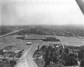
The Bon Marche was no longer the only occupant of the Tacoma Mall Shopping Center on the south side of Tacoma in October,1965 when this aerial photograph was taken. A full-line J.C. Penney's had opened at the southeast end of the large building complex and many smaller specialty stores had joined the two large department stores. Acres of free parking proved to be a major draw, and the enclosed mall design kept customers out of the wind and rain. The National Bank of Washington's circular building is prominent near the Mall; I-5 freeway, providing easy access to the Mall, runs along the photograph's left side. The Wapato Lake area is southeast of the Mall to the left of I-5, near the horizon. Most of the residential development surrounding the Mall has been converted over the years into commercial property.
Aerial photographs; Shopping centers--Tacoma; Bon Marche (Tacoma); National Bank of Washington (Tacoma); J.C. Penney Co. (Tacoma);
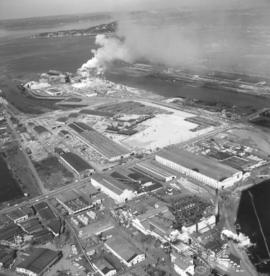
Smoke could be seen day and night billowing from the St. Regis Paper Co. facility on Tacoma's industrial Tideflats. Aerial view taken in late June, 1966, shows that the area continued to grow with new construction. St. Regis was located conveniently between the Puyallup and St. Paul Waterways. Photograph ordered by St. Regis Paper Co.
Aerial photographs; St. Regis Paper Co. (Tacoma)--1960-1970; Smoke--Tacoma;
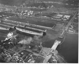
ca. 1953. This aerial view of the northeast section of the Tacoma tideflats from 1953 shows part of the Port of Tacoma, lower left, and the 185-acre Port Industrial Yard which was acquired by the Port in 1959. Five mothballed WWII baby flattops are moored in the Port Industrial Waterway. The incomplete Port Industrial Waterway bridge, later named the Blair Bridge, can be seen at the right. The bridge opened for traffic on November 14, 1953. The bridge is 712 feet long with a 40 foot roadway and 5 feet of sidewalk on one side only. It has a clearance at high tide of 12 feet. There is a 150 foot channel between the main piers for the passage of shipping vessels. The two main channel piers are 45 x 55 foot and house the operating machinery, counterweights and electrical equipment for opening and closing the span drawbridge. They are the equivalent in height, measured both above & below the water, to a seven story building. The cost of the bridge was $1,600,000. (TNT 11/13/1953, special section #D)
Aerial photographs; Port of Tacoma (Tacoma)--1950-1960; Aircraft carriers--Tacoma--1950-1960; Harbors--Tacoma; Aerial views; Blair Bridge (Tacoma); Port Industrial Waterway Bridge (Tacoma); Vertical lift bridges;