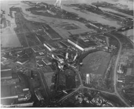
Aerial photographs of the Middle Waterway and the Tideflats area were taken on behalf of Malcolm McGhie in December, 1957. The St. Paul & Tacoma Lumber Co. facilities, sawmill, and log ponds are toward the center of the photograph. The St. Regis plants are, with smokestacks billowing, are near the top of the picture. Forty-five years later, the Tideflats landscape would be quite transformed. The City Waterway (now Thea Foss Waterway), although not in this picture, would no longer have docks, plywood mills, shipyards and warehouses crowding its sides. A 29.3 million dollar Museum of Glass and the adjoining Chihuly Bridge of Glass would be the first of millions of dollars of improvement to the area. TPL-5893
Aerial photographs; Middle Waterway (Tacoma); St. Paul & Tacoma Lumber Co. (Tacoma); St. Regis Paper Co. (Tacoma)--1950-1960;
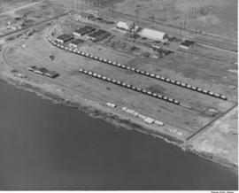
An aerial photograph of the Hooker Electrochemical plant in the Tideflats was taken on July 24, 1957, for possible order by the company. Storage tanks appear to be loaded on railroad cars on two parallel tracks. Hooker was the second chlor-alkali plant in the United States and the first caustic soda plant in the Pacific Northwest. This was apparently an aerial view of an area of Hooker Electrochemical Co. on Industrial Waterway.
Aerial photographs; Hooker Electrochemical Co. (Tacoma); Chemical industry--Tacoma--1950-1960;
Aerial photographs of the Huntington Rubber Mills were taken on July 13, 1957. This is possibly the Seattle plant at 35 W. Lander. The business occupied a large chunk of land bordered by several roads. There were at least four separate buildings making up the plant. Photograph ordered by Huntington Rubber Mills.
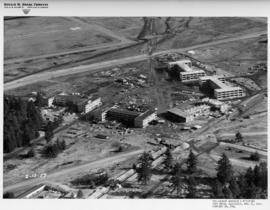
Construction at Fort Lewis remained strong in the mid-1950's as the military population continued to grow. February 12, 1957, aerial photographs show two company barracks and utilities structures being built at the south end of Gray Field. Donald M. Drake Co. of Portland, Oregon, apparently were involved in Contract #3706. Photograph ordered by the Donald M. Drake Co.
Aerial photographs; Building construction--Fort Lewis; Donald M. Drake Co. (Portland, Or.);
Aerial photographs of the south end of Gray Field on Fort Lewis were taken on February 12, 1957. Construction appears to be continuing on two company barracks and utilities building. Roads will have to be extended to meet the new quarters. Photograph ordered by Donald M. Drake Co., Portland, Oregon. TPL-10352
Aerial photographs; Building construction--Fort Lewis; Donald M. Drake Co. (Portland, Or.);
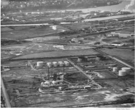
Aerial photographs were taken on December 4, 1956, at the request of U.S. Oil & Refining Co. of the petroleum tank "farm" on the Tideflats heading toward town. The huge light-colored cylinders dot the landscape. U.S. Oil had broken ground in July, 1955, for a new 10-million dollar oil refinery on an 120 acre site in the Tideflats. TPL-5897
Aerial photographs; Storage tanks--Tacoma; US Oil & Refining Co. (Tacoma);
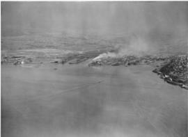
Aerial of the Port of Tacoma, taken from over Commencement Bay heading into the Port. Tacoma can be seen as the forested area on the right dotted with buildings, with the Tideflats laying to the left of the bridge shrouded densely with industrial smoke.
Aerial of the Port of Tacoma, taken from over Commencement Bay heading into the Port. Tacoma can be seen as the forested area on the right dotted with buildings, with the Tideflats laying to the left of the bridge shrouded densely with industrial smoke.
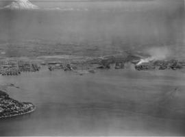
Aerial of the Port of Tacoma, taken from over Commencement Bay heading into the Port. Mount Rainier looms whitely in the background. Browns Point can be seen in the left foreground, with the fingers of the port and the inlets of waterway further back.
Aerial of the Port of Tacoma, taken from over Commencement Bay heading into the Port. Mount Rainier looms whitely in the background. Browns Point can be seen in the left foreground, with the fingers of the port and the inlets of waterway further back.
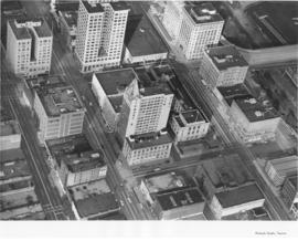
Aerial photograph of downtown Tacoma to show the spired Puget Sound National Bank building at 11th and Pacific (1119 Pacific Ave.) To the building's left is Peoples Department Store at 1101-07 Pacific and to its right is the National Bank of Washington, 1123 Pacific, the 2002 location of the Tacoma Art Museum. Behind facing A Street is the Federal Building and the Post Office at 1102 A Street. The city appears divided into a grid of large office buildings. The streets, left to right, vertically are Commerce, Pacific and A Street. They are divided by, top to bottom, by 11th Street and 12th Street. Left to right at the top of the picture are the Rust building at 950 Pacific, the Washington Building at 1019 Pacific and the Tacoma Building at 1017-21 A Street. Across 11th Street from the Tacoma Building is the Perkins building at 1101 A Street.
Puget Sound National Bank (Tacoma); Aerial photographs;
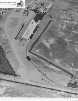
Aerial view of Reichhold Chemical Co. on the Tideflats. Reichhold manufactured chemicals used by the plywood industry. Occupying 51 acres of land, the company was a large concern that would employ over 100 people.
Aerial photographs; Building construction; Reichhold Chemicals, Inc. (Tacoma);
Aerial view of Reichhold Chemical Co. on the Tideflats. Reichhold manufactured chemicals used by the plywood industry. Occupying 51 acres of land, the company was a large concern that would employ over 100 people.
Aerial photographs; Building construction; Reichhold Chemicals, Inc. (Tacoma);
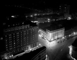
ca. 1920. View of 9th and Broadway taken from the roof of the Medical Arts Building. Night scene showing the Winthrop Hotel (773 Broadway), left, and an illuminated Pantages Theater (901 Broadway) building.
Aerial photographs; Hotel Winthrop (Tacoma); Hotels--Tacoma--1920-1930; Pantages Theater (Tacoma);