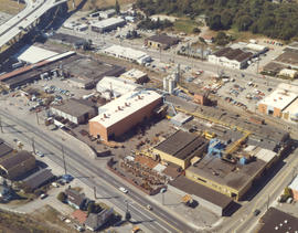
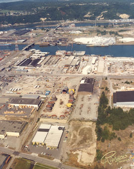
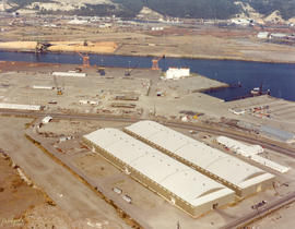
ca. 1976. Atlas Foundry by air in 1976. Established in 1899, Atlas's sprawling plant in the 3000 block of South Wilkeson was bordered by South Tacoma Way as well as Wilkeson (on right). Center St. is near the top. The Sprague Ave. overpass is in upper left corner along with offramp leading to Hwy 16. The plant's original buildings are near Wilkeson St. Atlas Foundry has been known as Atlas Castings & Technology since 2002. Photograph ordered by Atlas Foundry & Machine Co.
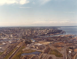
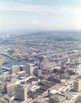
1975 Richards color stock footage. Aerial view of downtown Tacoma and industrial Tideflats on July 24, 1975. Major banks, stores and office buildings are separated from factories and mills by the City (now Thea Foss) Waterway.
Aerial views; Aerial photographs; City Waterway (Tacoma); Business districts--Tacoma--1970-1980;
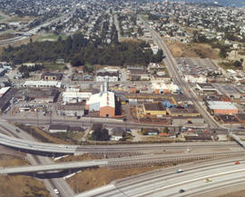
ca. 1975. 1975 Richards color stock footage. Aerial view of Tacoma Tideflats. The view above is believed to be Concrete Technology's property on the Port of Tacoma Rd. The area was bordered by E. 11th St. and Lincoln Ave. The body of water below is believed to be the Blair Waterway (formerly Port Industrial Waterway). The Puyallup River is near the top of the photograph.
1976 Richards color stock footage. Industrial tideflats by air on October 4, 1976. Waterway is believed to be the Blair (formerly Port Industrial) Waterway.
1975 Richards color stock footage. View by air of northeastern section of Tacoma's industrial area, the Tideflats, in late summer of 1975. Waterway closest to the top of photograph is the Hylebos; the Blair (formerly Port Industrial) Waterway is the other body of water shown above. Plant pictured is believed to be Concrete Technology Corporation.
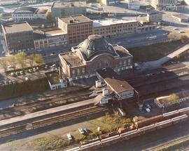
ca. 1975. 1975 Richards color stock footage. Shadows are creeping up on the venerable Union Station, 1717 Pacific Ave., in this 1975 aerial view. By 1975, the magnificent structure was showing its age. A proposed $14,000,000 shopping center/transportation complex sought to restore the station to its former splendor. "Depot Galleria" hoped to add two large buildings to the north and south of the station which would house department stores or perhaps include a major hotel. The Union Station interior would have had a remodeled "Gay '90s" look with the glass dome skylight admitting light to central atrium gardens. Three parking levels would provide parking for 1500 cars. The station would continue to serve as an Amtrak passenger terminal. These ambitious plans by Malls North and BNL Development Corporation (subsidiary of Burlington Northern) would not be realized. (TNT 2-23-75, A-1 article)
Aerial views; Aerial photographs; Union Station (Tacoma); Railroad stations--Tacoma--1970-1980;
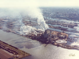
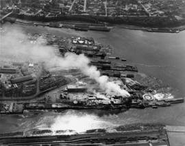
1976 Richards color stock footage. This is believed to be the St. Regis Paper Co. facility as seen by air on October 4, 1976. Massive clouds of smoke and steam emerging from the plant will soon be dispersed by the wind. This view shows several of the city's waterways and a portion of downtown Tacoma. The placid waters of the Puyallup, St. Paul, Middle and City (now Thea Foss) Waterways and the 11th St. Bridge (now Murray Morgan Bridge) are on view.
Aerial views; Aerial photographs; St. Regis Paper Co. (Tacoma)--1970-1980; Industrial facilities--Tacoma--1970-1980; Smoke--Tacoma; Puyallup Waterway (Tacoma); St. Paul Waterway (Tacoma); Middle Waterway (Tacoma); City Waterway (Tacoma);
ca. 1975. 1975 Richards color stock footage. Encroaching shadows seek to wrap themselves around the landmark Union Station located at 1717 Pacific Avenue. In 1975 the station still served as an Amtrak passenger terminal. Efforts were made to restore the station to its former glory with the proposed $14,000,000 "Depot Galleria" shopping/transportation complex; however, these plans were stalled. Also visible in this aerial view is the multi-storied Albers Mill, located to the rear of the station at 1821 Dock St. TPL-7982
Aerial views; Aerial photographs; Union Station (Tacoma); Railroad stations--Tacoma--1970-1980; Albers Bros. Milling Co. (Tacoma);
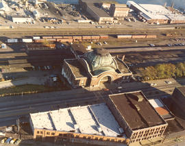
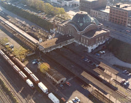
ca. 1975. 1975 Richards color stock footage. Aerial view of rear of Union Station, 1717 Pacific Ave. as seen in 1975. Fast-forward 30+ years later and the landscape has changed drastically. SR-705 is now where the railroad tracks once ran. The parking lot to the left of the station is now the location of the Washington State History Museum; the Federal Courts are located to the north in a new wing. The five-story building on Pacific Ave. on the extreme left of the photograph is now the University of Washington Bookstore. TPL-2402
Aerial views; Aerial photographs; Union Station (Tacoma); Railroad stations--Tacoma--1970-1980; Railroad tracks--Tacoma--1970-1980;
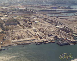
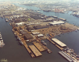
1976 Richards color stock footage. Overall aerial view of the bustling Port of Tacoma in October of 1976. Numerous ships are in port ready to load and unload cargo.
Aerial photographs; Aerial views; Cargo ships--Tacoma--1970-1980; Shipping--Tacoma--1970-1980; Port of Tacoma (Tacoma);
ca. 1976. Aerial view of longtime Tacoma foundry, Atlas Foundry & Machine Co., taken in the spring or summer of 1976. The company was founded in 1899 and began making iron castings for the Northwest logging industry. After the foundry was purchased by the Long family 30 years later, it began making steel as well as iron. By the 1930's, half of the firm's production was steel castings. Atlas is still in business in the 21st century; it is now known as Atlas Castings & Technology. This aerial photograph of the foundry in 1976 shows the city and roadways have grown in the 77 years since Atlas was founded. Atlas is bordered by Wilkeson (the long street extending vertically on the right) and South Tacoma Way (bottom) with Center St. on top. Stanley Elementary School is at the end of Wilkeson (top of photograph). I-5 freeway is on the bottom of photograph with the exits to So. 38th St. and Hwy 16 above. At the left corner of picture is the 25th St. bridge and Sprague Ave. (www.atlascastings.com)
ca. 1975. 1975 Richards color stock footage. Closer aerial view of what is believed to be Concrete Technology Corp., 1123 Port of Tacoma Rd., on the Tacoma tideflats. This photograph was possibly taken in the summer of 1975. Concrete Technology dealt in prestressed and precast concrete. Waterway shown is believed to be the Blair Waterway (formerly Port Industrial Waterway).
ca. 1975. 1975 Richards color stock footage. Aerial view of industrial facility on Tacoma's tideflats. This is believed to be Concrete Technology's plant on Port of Tacoma Rd. Waterway is believed to be the Blair (formerly Port Industrial) Waterway.
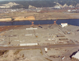
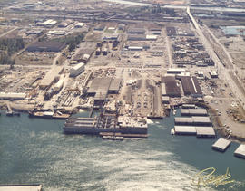
1976 Richards color stock footage. October, 1976, aerial view of Tacoma tideflats including various industrial facilities. This unidentified plant is believed to be along the Blair Waterway .
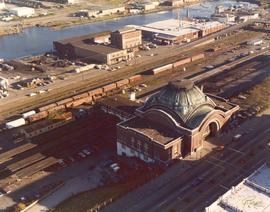
ca. 1975. 1975 Richards color stock footage. Rear view of Union Station. Located on lower Pacific Avenue, Union Station was built in 1911 by the Hurley-Mason Co. Although the station is still there some thirty years after this 1975 aerial photograph was taken, its surroundings are quite different. SR-705 would be built to run behind the station and the last train would leave Union Station in June of 1984. The Washington State History Museum is now on the site of the former tree-lined parking lot while the Federal Courts are now located in a new wing north of Union Station. Plans to construct a shopping center/transportation complex including Union Station were shelved after many years of trying. TPL-2399
Aerial views; Aerial photographs; Union Station (Tacoma); Railroad stations--Tacoma--1970-1980; Railroad tracks--Tacoma--1970-1980;
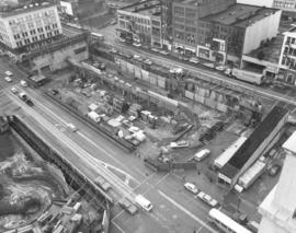
ca. 1970. 1970 Richards stock footage. Aerial view of parking garage construction. To deal with the increasing parking problem in downtown Tacoma, approval was obtained to build two large public garages. Construction had begun in 1970 on the Commerce St. site across from the upcoming (National) Bank of Washington Plaza; the other garage would be built closer to 9th. Two of downtown's escalades are visible next to and near the site. The garage would be dubbed "Park Plaza South" and be built of precast and pre-stressed concrete. There would be room for 381 cars. The Park Plaza South garage would be officially opened on November 5, 1970.
Aerial views; Building construction--Tacoma--1970-1980; Parking garages--Tacoma--1970-1980; Conveying systems--Tacoma--1970-1980; Urban renewal;
Look by air of St. Regis Paper Co. Smoke billowing from St. Regis' stacks was a familiar sight for local residents. The company remained committed to the reduction of air and water pollution from their pulp and paper mills. Per its 1970 annual report, St. Regis spent a total 2.5 million dollars for pollution-abatement construction that year. Photograph ordered by Hylebos Industries, Inc. (1970 St. Regis Annual Report - p 3 - article)
Aerial views; St. Regis Paper Co. (Tacoma)--1970-1980;
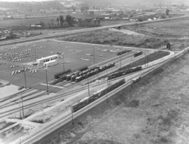
Automobile unloading facility. This is believed to be the Milwaukee Road Union Pacific yard in Kent recently dedicated in October of 1969. Cars were brought in by rail and due to the close proximity of the Valley Freeway and 277th St., easily transported elsewhere. They would roll down the ramps and could be parked, when necessary, in the yard's enormous parking lot. Aerial view of complex taken in April of 1970.
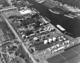
Aerial view on May 26, 1970, of the Tacoma industrial Tideflats, featuring Hooker Chemical and Hylebos Waterway. By 1970, Hooker had been in Tacoma for 41 years. It had begun in 1929 with production of 13 tons of chlorine a day and a work crew of 40. In 1969, production had increased to 400 tons with the aid of 300 employees. Hooker was the first to produce caustic soda. Chlorine and caustic soda were sold mostly to the pulp/paper industry in the Pacific Northwest. By 1969, Hooker Chemical was a wholly owned subsidiary of Occidental Petroleum. (TNT 2-2-69, B-8 -article) Photograph ordered by Hylebos Industries, Inc.
1971 color Richards stock footage. Aerial of Division and N. Yakima neighborhood. This view is taken almost directly overhead the three apartment houses: Casablanca, Rutland and Woodstock (l-r) on May 27, 1971. The Casablanca and Rutland apartments were on N. Yakima while the Woodstock's address was actually on N. 1st. The Casablanca was the youngest of the three, built in 1944, while the Rutland and Woodstock were erected in the early 1900s. The building with grey roof and brownish-red trim up the street from the apartments is Walker Chevrolet. It is unknown whether the car-filled lot behind the apartments was for tenant parking or used partially by the car dealership. Major streets in this area are N. Yakima in front of the three apartment houses and 1st St. which veers from Division (farthest right).
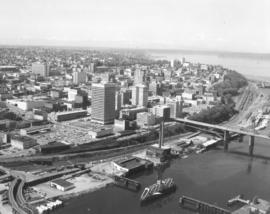
ca. 1971. 1971 Richards stock footage. Aerial photograph of the City of Tacoma in 1971, with emphasis on the downtown business district and City Waterway (now Thea Foss Waterway). Buildings closest to the waterway and the 11th Street Bridge (now Murray Morgan Bridge) include the Perkins and Tacoma Buildings that flank the bridge, the new Pacific National Bank of Washington Plaza tower, the Rust and Washington Buildings. Also visible are the Medical Arts Building (now Municipal Building) and further in the background, the County-City Building. Two new parking garages on Pacific Ave. were completed in 1970-71 providing hundreds of parking spaces and addressing the pleas for more parking stalls.
Aerial views; City Waterway (Tacoma); Cityscapes; 11th Street Bridge (Tacoma); Perkins Building (Tacoma); Tacoma Building (Tacoma); Pacific National Bank of Washington (Tacoma); Rust Building (Tacoma); Washington Building (Tacoma);
ca. 1971. 1971 color Richards stock footage. Aerial view of downtown business district featuring the new Bank of Washington Plaza with its 24-story tower. Directly across Pacific Avenue from the new skyscraper is the Park Plaza South parking garage, also recently opened with 381 parking stalls. To the left of the Pacific National Bank's Bank of Washington Plaza is the familiar spire of Puget Sound National Bank, once the tallest structure on the West Coast. Also in view is the City (now Thea Foss) Waterway with the 11th St. Bridge (now Murray Morgan Bridge). The Tacoma Building and Perkins Building flank the bridge. TPL-2316
Aerial views; Pacific National Bank of Washington (Tacoma); Puget Sound National Bank (Tacoma); Banks--Tacoma; Parking garages--Tacoma--1970-1980; 11th Street Bridge (Tacoma); Tacoma Building (Tacoma); Perkins Building (Tacoma); City Waterway (Tacoma);
1971 color Richards stock footage. Aerial northeast view of downtown Tacoma overlooking City (now Thea Foss) Waterway and industrial Tideflats. The snowy tip of Mount Rainier is barely visible through the haze. Wheeler-Osgood Waterway is the small waterway on the left which leads into the City Waterway. Major buildings of note in downtown area include Tacoma and Perkins Buildings flanking the 11th Street Bridge (now Murray Morgan Bridge); the cluster of buildings on Pacific including Washington and Rust Buildings, Puget Sound National Bank, the new Bank of Washington Plaza, and Schoenfelds Furniture to the right. Neighborhoods seen in the distance to the center and right of photograph are part of East Tacoma.
Aerial views; City Waterway (Tacoma); Wheeler-Osgood Waterway (Tacoma); Tacoma Building (Tacoma); Perkins Building (Tacoma); Washington Building (Tacoma); Rust Building (Tacoma); Puget Sound National Bank (Tacoma); 11th Street Bridge (Tacoma);
1971 color Richards stock footage. Aerial view of Point Defiance and vicinity. The Point Defiance Park is on the right with the Boathouse prominently displayed. The ferry landing and Tacoma Yacht Club and mooring are in the upper center. ASARCO (American Smelting & Refining Co.) is near the top with a glimpse of the giant smokestack along the right upper edge.
Aerial views; Point Defiance Park (Tacoma); Parks--Tacoma--1970-1980; Boathouses--Tacoma; Boats; Tacoma Yacht Club (Tacoma); Mooring; American Smelting & Refining Co. (Tacoma); Smelters--Tacoma--1970-1980;
1971 color Richards stock footage. Aerial view of ASARCO (American Smelting & Refining Co.) in May of 1971. Two ships are docked to be loaded with metals for shipment outside Washington state. The famous ASARCO smokestack is near the right corner edge; the 571-foot giant chimney was imploded in 1993, nine years after the plant had closed. The dark gray color of the plant grounds is in stark contrast to the deep blue waters of Puget Sound; the color is due to slag.
Aerial views; American Smelting & Refining Co. (Tacoma); Smelters--Tacoma--1970-1980; Smokestacks--Tacoma;
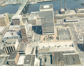
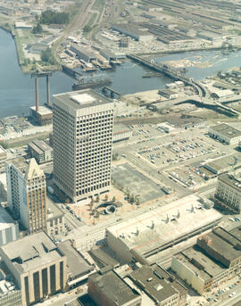
ca. 1971. 1971 color Richards stock footage. Aerial view of downtown commercial district with glimpse of industrial Tideflats. This is a look at the area around So. 12th and Pacific Avenue with the towering Bank of Washington Plaza attracting the viewer's eye. The giant circle surrounded by a spaced planting of trees is the plaza's fountain. A circular staircase leads down to the fountain and courtyard, with a restaurant and specialty shops included. Directly across the street from the fountain is the Park Plaza South parking garage. The Pacific National Bank of Washington's closest banking neighbors are Puget Sound National Bank (with spire) and Seattle-First, in left corner. The City Waterway (now Thea Foss Waterway) is in the background with the railroad bridge and the 15th St. Bridge connecting the city with the industrial Tideflats area.
Aerial views; Pacific National Bank of Washington (Tacoma); Puget Sound National Bank (Tacoma); Seattle-First National Bank (Tacoma); Banks--Tacoma; Parking garages--Tacoma--1970-1980; City Waterway (Tacoma); Business districts--Tacoma--1970-1980;
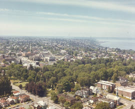
ca. 1971. 1971 color Richards stock footage. Aerial view of tree-filled Wright Park, Tacoma General Hospital (in center) and Commencement Bay, taken on a clear day in 1971. Park grounds are carefully manicured and pathways clearly marked. Dedicated in 1886, Wright Park provided a peaceful alternative to busy city life.
Aerial views; Wright Park (Tacoma); Parks--Tacoma--1970-1980; Tacoma General Hospital (Tacoma); Commencement Bay (Wash.);
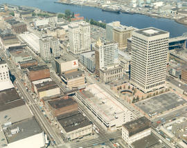
ca. 1971. 1971 color Richards stock footage. Aerial view of downtown commercial district featuring a mixture of new construction and older buildings. The first highrise built in downtown Tacoma in 40 years, the Pacific National Bank of Washington Plaza, at 24-stories, towered over its banking neighbors, Puget Sound National Bank and Seattle-First National Bank. Adding to new construction on Pacific Avenue was the Park Plaza South parking garage, which provided much needed parking stalls for shoppers and workers. They joined older buildings including Peoples department store, Washington Building, Tacoma Building and slightly older Greyhound Bus Terminal, considered ultra-modern when constructed in 1958.
Aerial views; Pacific National Bank of Washington (Tacoma); Puget Sound National Bank (Tacoma); Banks--Tacoma; Peoples (Tacoma); Washington Building (Tacoma); Tacoma Building (Tacoma); Greyhound Bus Terminal (Tacoma); Parking garages--Tacoma--1970-1980;
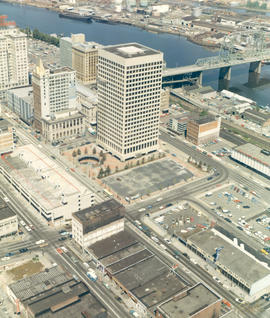
ca. 1971. 1971 color Richards stock footage. Aerial view taken on a clear day in 1971 of the downtown business district, featuring area impacted by urban renewal. New structures include the massive Bank of Washington Plaza with its 24-story tower (including helipad) and circular sunken fountain, and two new parking garages- Park Plaza South and North to aid in alleviating parking problems for shoppers and workers. This aerial photograph also shows the deep blue waters of the City (now Thea Foss) Waterway and a portion of the 11th Street Bridge (now Murray Morgan Bridge) that connects the city with the industrial Tideflats. Other notable structures include the Puget Sound National Bank with its spire; Peoples department store next door; the Rust and Washington Buildings, both with neon signs advertising other banks--American Federal Savings and Bank of California, respectively; Tacoma Building and Seattle-First National Bank (formerly Bank of Tacoma).
Aerial views; Pacific National Bank of Washington (Tacoma); Puget Sound National Bank (Tacoma); Banks--Tacoma; Rust Building (Tacoma); Washington Building (Tacoma); Tacoma Building (Tacoma); Parking garages--Tacoma--1970-1980; City Waterway (Tacoma);
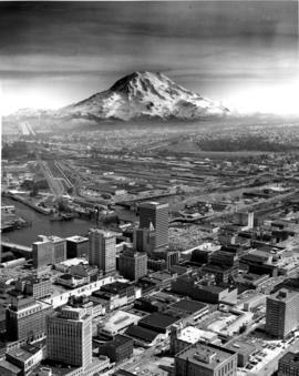
ca. 1971. Customer copy of downtown Tacoma landscape taken from the air, circa 1971. Snow-capped Mount Rainier looms in the background. Prominent buildings include the Art-Deco styled Medical Arts Building (now the Municipal Building) in lower left; Puget Sound National Bank with its distinctive spire; the 22+ story Bank of Washington Plaza building, the Washington Building with the neon Bank of California sign on its root; and Schoenfelds furniture store.
Aerial views; Business districts--Tacoma--1970-1980; Rainier, Mount (Wash.); Medical Arts Building (Tacoma); Puget Sound National Bank (Tacoma); Washington Building (Tacoma); L. Schoenfeld & Sons (Tacoma); Pacific National Bank of Washington (Tacoma);