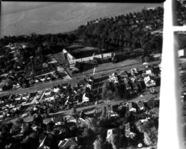
Aerial view of the Tacoma tideflats and Port of Tacoma. TPL-2251 Lincoln Ave. runs across the front of the photograph, with the Stauffer Chemical plant shown. The body of water in the center of the picture is the Port Industrial Waterway. East 11th Street runs between the waterway and Commencement Bay. The partially completed Port Industrial Waterway bridge can be seen, also the mothballed WWII baby flattops and the Port of Tacoma with its piers 1 & 2. The land curves around the right side of the picture ending in Browns Point.
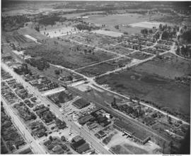
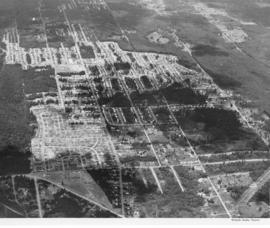
Aerial photographs. A large number of photographs of the South Tacoma area were taken in one day by airplane on behalf of North Pacific Bank, which was based in that area. Multi-lane road is possibly South Tacoma Way with People's Warehouse on the right and possibly Vaughan Lumber towards the center. S 66th St. intersects towards the center of the photo with South Tacoma Way; Mount Tahoma High School would later be built on the undeveloped land nearby.
Aerial photographs. The wing of an airplane is visible as aerial photographs were taken of the South Tacoma and possibly other local areas on June 15, 1953. The photo appears to be looking north toward Vashon Island. There is a gravel pit to the right. There were still large areas of undeveloped and wooded land at this time in Tacoma's history. Photograph ordered by North Pacific Bank.
Aerial photographs. Photographs taken from an airplane in June, 1953, show the South Tacoma area as it was back then. Rows of homes and businesses are interspersed with stretches of unoccupied, wooded land. Surprisingly, there is little or no traffic on South 56th St., believed to be on the extreme right, quite unlike today. Photograph ordered by North Pacific Bank.
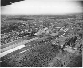
Aerial photographs. The South Tacoma area in the early 1950's was still vastly undeveloped. Aerial photographs shot on behalf of North Pacific Bank, based in South Tacoma, show large stretches of unoccupied land which remained heavily wooded. The Northern Pacific Railway shops can be seen about the middle of the picture on South 51st & Adams with the South Tacoma Air Park and Tyler Street nearby. TPL-2058
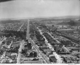
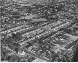
Aerial photographs. Several aerial photographs of the South Tacoma area were taken on behalf of North Pacific Bank in mid-June, 1953. This photo shows South Tacoma Way looking southward; even then, traffic was heavy on this major roadway. Businesses and homes dot the landscape with a noticeable amount of trees and foliage remaining. Old Tacoma Cemetary is believed to be on the left side of the photograph. TPL-6471
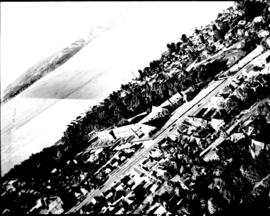
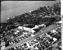
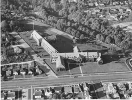
This was how Marymount Military Academy appeared from the air on July 28, 1953. The Academy was the only military school in Washington State. Located in what would now be Spanaway, the school was run by the Dominican Sisters, a Catholic teaching order. Young boys aged 6-16 were accepted for enrollment at this boarding school. Ground was broken at the site in July of 1922 and the school was dedicated in May of 1923. Built at a cost of $200,000 on the former "Shangarry" estate of J. Shields, Marymount originally was built in the Lombardine Mission style with modern gym, pool and infirmary. Enrollment was capped at 150 students; however, lessening enrollment and higher operating costs forced closure of the school in 1976. The property was purchased in the 1980's by Harold LeMay, who used much of it to house his antique car collection. TPL-9701
Aerial photographs; Marymount Military Academy (Spanaway); Private schools--Spanaway; Military education--Spanaway;
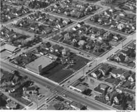
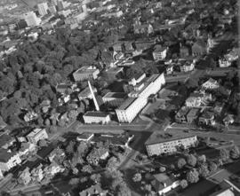
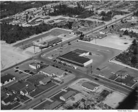
Aerial photograph of Sixth Avenue. This aerial photograph of Sixth Avenue near Union shows how the nearby streets are neatly partitioned into grids with well-kept homes and businesses. Near the center of the photograph is the new Tradewell supermarket #30 with its large tower jutting into the sky and expansive parking lot. On the next block a portion of the new Sixth & Washington Square Building can be seen. Photograph ordered by Carl Swanson, Tradewell Stores, Inc.
Aerial photographs; Tradewell Stores, Inc. (Tacoma); Sixth & Washington Square Building (Tacoma);
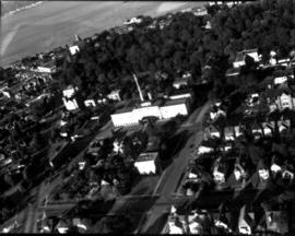
ca. 1938. Aerial view of North End Tacoma showing Annie Wright Seminary, surrounding neighborhood and Commencement Bay. The Tudor Gothic building was built in 1924 on a design by Sutton, Whitney & Dugan.
ca. 1952. Aerial view of Northern King County, north of Seattle and west of Lake Washington. The large building on the left with the marquee is most probably the Crest Movie Cinema, located at 16505 5th Ave. NE, Seattle. The homes here appear to mid sized and are located on large lots. The streets are laid out on a square block formation. There are still large sections of woods in view.
ca. 1952. Aerial photograph of residential area, most probably Mountlake Terrace, circa 1952. Mountlake Terrace was an expanding area north of Seattle, in Snohomish County, just north of the King county line. The largely residential area served as a bedroom community for Seattle workers. The area surrounding is still heavily forested and undeveloped. The streets are laid out in curves, forming cul de sacs.
ca. 1952. Aerial photograph of residential area, most probably Mountlake Terrace. Mountlake Terrace was an expanding area north of Seattle, in Snohomish County, just north of the King county line. The largely residential area served as a bedroom community for Seattle workers. The area surrounding is still heavily forested and undeveloped. The streets are laid out in curves, forming cul de sacs.
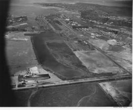
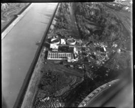
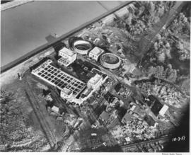
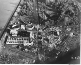
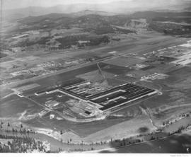
Aerial photograph of sewage disposal plant. Progress was being made in the construction of a new waste disposal facility on Cleveland Way near the Puyallup River in October, 1951. Aerial view of plant; large circular structures are digesting tanks, square building between them the digestion control building. Raw sludge would be processed in the digesting tanks where ultimately it would be filtered, peeled off in cakes, and then hauled away for fertilizer. According to a 12/12/51 article in the News Tribune, the plant was designed to handle 27 million gallons of sewage a day. Photograph commissioned by Hoagland-Findlay. TPL-8825
Aerial view of sewage disposal plant. Progress photograph of the new sewage disposal plant on Cleveland Way was taken by air on October 3, 1951. Construction continues on the new plant near the Puyallup River under the direction of Hoagland-Findlay Engineering Company who had the low bid of nearly $1,400,000. The two large circular structures are digesting tanks where raw sewage would be digested and eventually turned into fertilizer. Rectangular building appears to be a 14,000,000 gallon sedimentation tank. Photograph commissioned by Hoagland-Findlay. TPL-8824
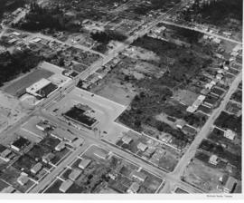
An aerial photograph of the Northgate shopping area. The building in the center of this June, 1951, photograph contains Larson's Department Store and Ridgecrest Super Market. Ordered by Phares Advertising. The area is mixed use with single-family residential areas near this commercial area.
Aerial photographs; Shopping centers--Seattle; Land use--Seattle--1950-1960; Real estate development--Seattle--1950-1960;
Scenic views from Eastern Washington. An aerial view of farm land, a sprawling building in the center, a plant in the upper right with what may be a Ralston Purina logo painted on a tower, and a small residential community in the upper left in one of the broad valleys of eastern Washington. A narrow river meanders through the foreground.
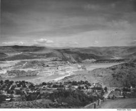
Scenic views from Eastern Washington. An aerial view of the housing area across the Columbia River from the utility facilities at Grand Coulee Dam. Mason City was built on one side of the river during the dam construction and Engineer's Town grew on the opposite side. This view shows the land forms above the river into the distance.
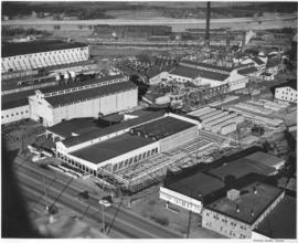
An aerial view of St. Paul and Tacoma Lumber Company. Colonel Chauncey Griggs, Addison Foster, Henry Hewitt, Jr. and Charles Hebard Jones purchased 83,000 acres of timber in 1888 from the Northern Pacific Raillroad company in the largest purchase of timberland in the nineteenth century. Then they built a giant sawmill on "The Boot", a low island off the main tideflats, bordered by branches of the Puyallup River and Commencement Bay. They built the first standard-guage logging railroad and introduced the band-saw to Pacific Northwest lumber operations. They built the St. Paul & Tacoma Lumber Company. (The Mill on the Boot, Murray Morgan)
Aerial photographs; Lumber industry--Tacoma--1950-1960; St. Paul & Tacoma Lumber Co. (Tacoma);
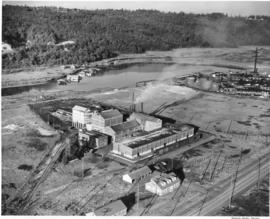
An aerial view of the Feltrok Insulation Manufacturing Company taken at 7 p.m. June 9, 1950. The company was located on the Tacoma tideflats. Pennsylvania Salt Manufacturing Company is seen on the right. Feltrok was purchased by the American Rock Wool Corporation in 1952. About 35 persons were employed in the Tacoma operation at that time. (Tacoma Reporter, 7/21/1952, p.3)
Aerial photographs; Feltrok Insulation Manufacturing Co. (Tacoma); Industrial facilities--Tacoma--1950-1960; Pennsylvania Salt Manufacturing Co. of Washington (Tacoma);
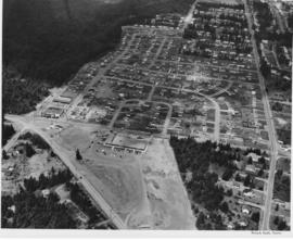
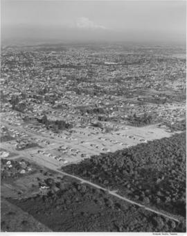
Studio stock negatives. An aerial view of residential neighborhoods in Pierce County. New housing developments with no or few trees are in the foreground.
Aerial photographs; Land; Land use--Tacoma--1940-1950; Housing developments--Tacoma--1940-1950;
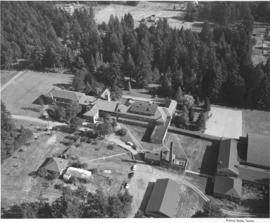
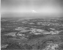
Studio stock negatives. An aerial view of rural Pierce County with open and wooded areas. Small groupings of buildings are dotted over the area. Mount Rainier is seen above the mist.
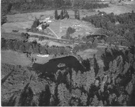
Studio stock negatives. An aerial photograph of a rural area with a highway running across it. A woods and lake are seen on the lower half while several buildings around a cleared area are seen above.
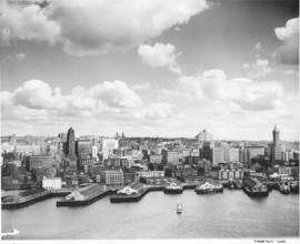
Aerial of Seattle skyline taken from above Elliott Bay. Piers jut into the bay with warehouses on them. Smith Tower is the taller building on the right. TPL-4749