Showing 824 results

Collections
Aerial Photography Image With digital objects
Print preview View:

D153156-8C

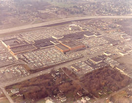
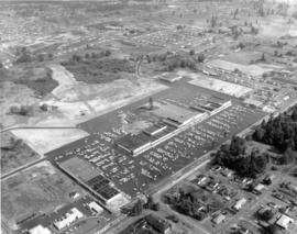
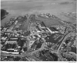
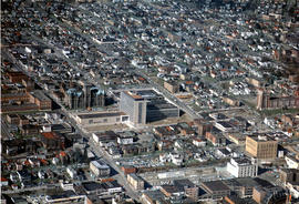
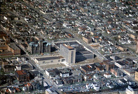
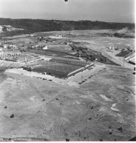
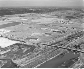
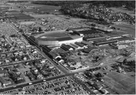
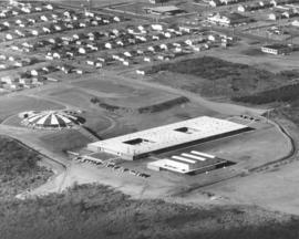
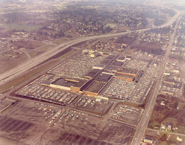
Aerial photograph of Northgate Shopping Center. Anchored by the Bon Marche and J.C. Penney stores, the Northgate Mall was the first enclosed shopping center in Seattle. Built in 1950, it was located five miles north of Seattle's downtown district. Anticipating growth in neighborhoods outside the downtown area, developers strategically placed the large shopping center between I-5 and 5th Ave. NE, allowing easy access from major roadways. Like the similarly designed Tacoma Mall, Northgate provided acres of free parking for its customers who could enjoy the enclosed, climate-controlled shopping center. Photograph ordered by Bell & Stanton, New York City.


Aerial photographs; Bon Marche (Seattle); Department stores--Seattle--1960-1970; J.C. Penney Co. (Seattle); Northgate Mall (Seattle); Shopping centers--Seattle--1960-1970; Express highways--Seattle--1960-1970;

D153156-4C

Aerial view of Northgate Shopping Center with focus on the red-tinted, multi-stored Bon Marche. Like the Tacoma Mall, the Northgate Mall was located next to the freeway, allowing easy access to the shopping center. It was approximately five miles north of downtown Seattle. Built in 1950, it was Seattle's first enclosed mall. The Northgate Mall offered acres of free parking and as the above December 23, 1967, photograph indicates, thousands were inside trying to finish up Christmas shopping. Photograph ordered by Bell & Stanton, New York City.


Aerial photographs; Bon Marche (Seattle); Department stores--Seattle--1960-1970; Northgate Mall (Seattle); Shopping centers--Seattle--1960-1970; Express highways--Seattle--1960-1970;

D153511-4

Aerial view looking downtown and including Tideflats on February 13, 1968, as requested by Puget Sound National Bank. Point Defiance is toward upper left. City's population is massed toward the left side of photograph; lower and right center are more sparsely occupied.


Aerial photographs; Cityscapes;

D154000-29C

1968 Richards Stock footage. Closer look at the 11th, Yakima and Tacoma Ave. business districts looking eastward toward the city's waterfront on February 13, 1968. Tacoma Vocational-Technical Institute's 317-foot radio tower is at lower foreground; across the street is the Washington State Armory. Block downhill is the County-City Building with enormous wings on left, Tacoma Public Library with round Carnegie Library section on right. Industrial Tideflats towards top of photograph including various waterways and St. Regis Paper Co.


Aerial views; Commercial streets--Tacoma--1960-1970; County-City Building (Tacoma); Tacoma Public Library (Tacoma); State Armory (Tacoma); Tacoma Vocational School (Tacoma); Towers--Tacoma;

D154000-33

1968 Richards Stock aerial footage. Wright Park. Located near Tacoma's downtown business district, the park with its shady trees and meandering paths provided a tranquil setting for urban dwellers. Lawn bowlers took advantage of the smooth manicured playing field and in the winter, skaters would venture onto the park's frozen ponds. The glassed-in Seymour Conservatory, still in use in 2005, was filled with exotic blossoms as well as native Northwest foliage. The Greek ionic-styled First Church of Christ, Scientist, located on Division directly across from the park, was built in 1911. The City Waterway (now Thea Foss) can be seen on the upper left of the picture with part of the industrial Tideflats in view.


Aerial views; Wright Park (Tacoma); First Church of Christ, Scientist (Tacoma); City Waterway (Tacoma);

A107984-10

Aerial photographs of the Huntington Rubber Mills were taken on July 13, 1957. This is possibly the Seattle plant at 35 W. Lander. The business occupied a large chunk of land bordered by several roads. There were at least four separate buildings making up the plant. Photograph ordered by Huntington Rubber Mills.


Aerial photographs; Huntington Rubber Mills (Seattle); Industrial facilities--Seattle;

D108639-2

Lakewood Center as pictured by air in August of 1957. Located near the busy streets of Bridgeport Way and Gravelly Lake Dr., the Lakewood Center was among the first of the nation's one-stop shopping centers. It underwent several expansions including a major addition in 1955 when the modified Colonial, shown above with an "open" triangular side, opened with fourteen new businesses. The shopping center was 15 minutes from downtown Tacoma, five minutes from McChord and ten from Fort Lewis. It provided an alternative shopping area for residents in the communities outside Tacoma city limits with the added attraction of more parking than in downtown Tacoma.


Aerial photographs; Lakewood Community Center (Lakewood); Shopping centers--Lakewood--1950-1960;

D108639-5

Aerial view of the Villa Plaza Shopping Center taken for its opening in August of 1957. One thing was clear: there was plenty of parking available for shoppers at Lakewood's newest shopping center, the Villa Plaza, and plenty of room for expansion if necessary. The Villa Plaza heavily advertised its free 4000-car parking lot and the convenience of many stores side-by-side including familiar names J.C. Penney's, Woolworth's and Rhodes Brothers. Acknowledging the buying power of suburbanites, these major department stores left their flagship operations downtown but garnered new shopping dollars by opening branches outside city limits. The Villa Plaza, like the older Lakewood Center, was closer to McChord and Fort Lewis than downtown.


Aerial views; Aerial photographs; Villa Plaza Shopping Center (Lakewood); Shopping centers--Lakewood--1950-1960; Parking lots--Lakewood;

A108235-1

An aerial photograph of the Hooker Electrochemical plant in the Tideflats was taken on July 24, 1957, for possible order by the company. Storage tanks appear to be loaded on railroad cars on two parallel tracks. Hooker was the second chlor-alkali plant in the United States and the first caustic soda plant in the Pacific Northwest. This was apparently an aerial view of an area of Hooker Electrochemical Co. on Industrial Waterway.


Aerial photographs; Hooker Electrochemical Co. (Tacoma); Chemical industry--Tacoma--1950-1960;

D111635-1

This was how Tacoma's Tideflats appeared from the air on January 3, 1958. The area was crowded with pulp and paper mills, lumber yards, log ponds and warehouses. Tacoma's easy access to rail and water made the transport of industrial and wood products a simpler process. View of, left to right, the City, Middle, St. Paul and Puyallup Waterways. The St. Regis plant was located on the finger between the Puyallup and St. Paul waterways in the buildings with the "L" shape. The St. Paul & Tacoma Lumber sawmill and buildings were close by, at the rear of the waterway in the loaf shaped buildings. In August 1957, St. Paul became an operating subsidiary of the St. Regis Paper Co. Photograph ordered by Malcolm McGhie.


Aerial photographs; St. Regis Paper Co. (Tacoma)--1950-1960; St. Paul & Tacoma Lumber Co. (Tacoma);

A112205-11

Aerial photographs of South Fort Lewis were taken on January 26, 1958. The carefully laid out design appears symmetrical, with identical buildings and parking lots on both sides of the wide field. These may have been newly constructed buildings. The view taken from the air gives the appearance of a architectural model setup. Forested lands are abundant on the property; there is plenty of space for expansion. Photograph ordered by Donald L. Drake Co.


Aerial photographs; Building construction--Fort Lewis;

A113921-2

Five bridges span the channelized Puyallup River in this aerial photograph taken in April of 1958 before the construction of I-5. The bridge at the bottom is the 21st Street Bridge. In the middle is the Puyallup River Bridge. Near the top, to the right of the river, is the Cushman Indian Hospital, soon to be the site of the Puyallup Tribal Casino.


Aerial photographs; Bridges--Tacoma;

A113921-3

Three bridges transverse the Puyallup River in aerial photographs taken by Richards Studio on April 22, 1958. The Tacoma Indian Hospital and grounds are visible at the top right of the photograph. Railroad tracks run parallel and under part of the bridges.


Aerial photographs; Bridges--Tacoma; Tacoma Indian Hospital (Tacoma);

A115129-8

Mount Rainier can be seen in the distance through the mist in this aerial photograph of Fox Island taken on June 16, 1958. Heavily wooded Fox Island is located between the Carr Inlet and Hales Passage, two miles northeast of McNeil Island in northwestern Pierce County. It was named in 1841 after Dr. J.L. Fox, an assistant surgeon of the Wilkes Expedition. The Fox Island Bridge can be spotted toward the center of the photograph. It spans 1,981 feet over Hales Passage and was completed in 1954. The bridge was opened by Governor Arthur Langlie and Anne Nelson, the first white girl born on Fox Island. Fox Islanders had to pay tolls on the new bridge; added to the expenses incurred with cars and gasoline, the cost of getting to Tacoma more than doubled. By 1956, the population on the island had declined to 115 families. Nearly a half-century later, according to the 2000 census, there were approximately 2800 people living on Fox Island. (History of Pierce County, Vol. 1, p. 59) TPL-9232


Aerial photographs; Bridges--Fox Island;

A115129-11

Aerial photographs of Tacoma's northend were taken on June 16, 1958. Looking toward Mount Rainier are the industrial Tideflats area. Smoke from many pulp and paper mills drifts over the landscape. The first wooded area nearest downtown would be Wright Park. The second large forested region in the middle is Garfield Park, near Annie Wright Seminary and the Tacoma Lawn Tennis Club, and the distinctive half-moon street. The largest green area, shaped somewhat like a boot, is Puget Park as it was in 1958. It may not be as large now.


Aerial photographs; Parks--Tacoma--1950-1960;

D116584-8C

ca. 1958. Aerial view of the neighborhood around Tacoma Avenue South near the new County-City Building circa 1958. In the center is the County-City Building, with its two wings and tower at 930 Tacoma Avenue South, built to replace the deteriorating Pierce County Courthouse immediately to its rear. The Romanesque old Courthouse at 1012 South "G" would be demolished and the area used as a parking lot. At left center is the Tacoma Public Library, 1102 Tacoma Avenue South. The Central School, 601 South 8th, is at right center edge but McDonald's is yet to be built next door on Tacoma Avenue South.


Aerial views; Aerial photographs; Cityscapes--Tacoma--1950-1960; County-City Building (Tacoma); Pierce County Courthouse (Tacoma); Tacoma Public Library (Tacoma); Central School (Tacoma); Streets--Tacoma--1950-1960;

D116584-9C

ca. 1958. This aerial view is looking west with focus upon the newly built County-City Building at 930 Tacoma Avenue South, circa 1958. The venerable Pierce County Courthouse, directly behind one of the County-City Building wings, was in poor shape and after much discussion, it was decided to build a new structure to replace it. Site preparation and excavation began in 1955 but the building would not be completed until 1959. Also in view are the Tacoma Public Library, directly across the street at 1102 Tacoma Avenue South, and the State Armory at 715 South 11th, behind the Pierce County Courthouse.


Aerial views; Aerial photographs; County-City Building (Tacoma); Pierce County Courthouse (Tacoma); Tacoma Public Library (Tacoma); State Armory (Tacoma); Commercial streets--Tacoma--1950-1960; Streets--Tacoma--1950-1960;

A116230-3

A series of aerial photographs taken by the Richards Studio shows what the downtown area looked like back in the summer of 1958. Several log dumps float in the City (now Thea Foss) Waterway to the right. Union Station, Harmon Mfg. and Hunt & Mottet are clustered toward one end of Pacific Avenue while the large banks and retail stores, including Schoenfelds, are further up the street. Heidelberg Brewing, on South "C", painted large lettering on their rooftop, easily visible from the air. There were still some green spots on the sprawling cityscape, including the massive Wright Park toward to the top.


Aerial photographs; Commercial streets--Tacoma--1950-1960;

A116230-2

A closer view of downtown Tacoma streets taken by air on August 14, 1958, shows the carefully laid out, primarily business district. Heidelberg Brewery was in the 2100 block of South "C" Street, two blocks west of Pacific Avenue, as the street gently curves. The Union Station is in the upper part of the picture, toward the right side. The buildings across the street would become part of the University of Washington-Tacoma campus. The Museum of Glass would also be built on Dock Street, accessible by Chihuly's Bridge of Glass, which would cross busy Pacific Avenue and railroad tracks. The Harmon Mfg. Co. and the Hunt & Mottet Co. buildings on Pacific are easily identifiable in this 1958 photograph. Sections of the downtown area were scheduled for an urban renewal project in the late 1950's. It is believed that the city would have to match some funding from the federal government in order that repairs and remodels of the older section could occur. TPL-10508


Aerial photographs; Commercial streets--Tacoma--1950-1960; Heidelberg Brewing Co. (Tacoma)--1950-1960;

A116227-3

Aerial photographs of the Tideflats area showing the new Educators Manufacturing Co.'s plant on Lincoln Avenue were taken on August 26, 1958. Educators Mfg. made school furniture. The company built a one million dollar facility on ten acres in the Tideflats for mass production of quality controlled classroom equipment. They apparently shared the same address with Buffelen Woodworking & Buffelen Sales Co. View of large plant with three connected buildings. Industrial area to the right of the photograph was the Reichhold Chemicals plant. Photograph ordered by Educators Manufacturing Co. (TNT suppl. 11-9-58, p. 4)


Aerial photographs; Educators Manufacturing Co. (Tacoma); Furniture industry--Tacoma--1950-1960; Industrial facilities--Tacoma--1950-1960;

A116205-1

Aerials of the Tacoma Tideflats industrial area were taken on August 20, 1958, on behalf of the Richards Studio. The Tideflats, already home to railroads, chemical plants and pulp mills, had plenty of room for future expansion. The long narrow street running horizontally is 11th Street with the Milwaukee Way intersecting it. Rows of railroad cars are lined up near the Sitcum and Milwaukee Waterways which are full of log dumps and platforms.


Aerial photographs; Industrial facilities--Tacoma--1950-1960;

A116910-8

This aerial view of the 46-acre Western Washington Fairgrounds, better known as the Puyallup Fair, and the surrounding area was taken on September 15, 1958. Several designated parking lots are crammed full of thousands of cars. Crowds stroll the Midway, enjoying the carnival rides and fair exhibits. The first fair opened on October 5, 1900, and it has run continuously since then, except for the war years of 1942-45. The complete fairgrounds can be seen including the Grandstand, exhibition halls, Midway, restaurants and the three official parking lots. (Photograph ordered by Puyallup Fair Association.) TPL-9273


Aerial views; Western Washington Fair (Puyallup); Grandstands--Puyallup;

C116284-1

ca. 1958. Copy of customer's print. An artist has placed his conceptualized drawing of the new regional shopping center, to be later called the Tacoma Mall, along with the future I-5 freeway over an aerial photograph of the South 38th St. area. Steele Street would lead into the shopping center from South 38th St. The Lincoln Heights housing development are the winding roads just off 38th St. The heavily wooded area near the Mall is presumably the Tacoma Cemetery and South Park. Allied Owners, Inc., had applied four times by August, 1958, for rezoning from a residential to regional shopping center district. They wanted to build a $20 million South Tacoma shopping headquarters, "Town Center," in an area surrounding South 43rd, South 48th & Pine Sts. and the freeway. Each time their request before the City Planning Commission had been denied. Photograph ordered by Allied Owners, Inc. (TNT 8-31-58, A-6)


Aerial photographs; Architectural drawings;

A118700-4

Aerials of the downtown area around Saint Helens, Tacoma Ave. So., and Division were taken by Richards Studio on December 22, 1958, for a sample book. Saint Helens Ave. and Tacoma Ave. So. meet at a "V" at Division. First Presbyterian Church can clearly be seen to the right. The new County-City Bldg. and Central Schools are on Tacoma Ave. on the right side of the photograph. The Medical Arts Bldg. is toward the top center on Saint Helens in a smaller "v". The street to the left of Saint Helens is Broadway. The last street to the left is no longer there; Schuster Parkway has taken its place. Further to the top left corner of the photograph, Puget Sound National Bank and Schoenfeld's furniture store are located. TPL-9298


Aerial photographs; Commercial streets--Tacoma--1950-1960; First Presbyterian Church (Tacoma); County-City Building (Tacoma); Medical Arts Building (Tacoma);

A120358-56

ca. 1959. Aerial of Tacoma, circa 1959. The gothic spires of Stadium High School can be seen about mid picture next to the City (Foss) Waterway. The Eleventh Street Bridge can be seen crossing the waterway next to downtown. To the lower left hand portion of the picture is the area where Schuster Parkway and Tacoma's waterfront will be constructed, it is during the fifties an area of graineries and mills. TPL-8689


Aerial photographs--1950-1960; City Waterway (Tacoma); Rainier, Mount (Wash.);

A120358-76

ca. 1959. Aerial of Hunt Junior High School, opened in 1958 to serve the growing communities of Fircrest and West Tacoma. When completed, the school designed by architect Robert Billsbrough Price was hailed as one of the most imaginative new schools in the country, and one of the least expensive per square foot. The reduced cost was due to the use of wood in construction, as opposed to concrete. The school's most distinctive feature was its mushroom shaped cafeteria/auditorium, growing from the landscape like something from P.T. Barnum. Hunt opened in 1958 with 27 teachers and 700 students under the guidance of Principal Trygve Blix. It was named after Henry F. Hunt, a Tacoma educator for 34 years who died in 1937. The school was expanded in 1964, 1974 and 1980. ("For the Record" by Winnifred L. Olsen) TPL-10159


Henry F. Hunt Junior High School (Tacoma); Public schools--Tacoma--1950-1960; Aerial photographs; Aerial views;

D141943-A

Aerial photograph on June 23, 1964, of Browns Point residence of lumber magnate Ben Cheney. Richards Studio notes indicate that the pilot would not fly lower due to complaints from local residents. The large sprawling complex in the center of the photograph was the Cheney estate, including the swimming pool and guesthouse on the left and private tennis court at the edge of the large stand of timber. The Cheneys, along with their near neighbors, sported well-manicured lawns. Photograph ordered by Cheney Lumber Co. (Additional information supplied by Eric Swanson) TPL-9417


Aerial photographs; Cheney, Ben B., 1905-1971--Homes & haunts;

D142189-4

Aerial photographs of the Port of Tacoma and industrial Tideflats taken in early July, 1964 as requested by Puget Sound National Bank. Looking north, photograph also shows thickly clustered Tacoma neighborhoods of the North and South ends in contrast with the much roomier Puyallup Valley areas. Besides the various waterways, including the City (now Thea Foss) Waterway connecting the business downtown area with the Tideflats, the widely channelized Puyallup River is clearly visible running from the right edge. Curving road left of the Puyallup River is Pioneer Way. Salishan and Swan Creek Park areas are in the wooded section left center. I-5 construction is also underway.


Aerial photographs; Puyallup River (Wash.);

D141601-8

Bridgeport Way is the curving road on the left side of this April 30, 1964, aerial photograph of Lakewood. The Lakewood Center, one of the earliest shopping centers in the country, is east of Bridgeport near the photo's bottom. The larger Villa Plaza Shopping Center, with its enormous 4000-car parking lot, is in the photo's center. McChord AFB is in the left top corner. Steilacoom Lake is on the right. Photograph ordered by Puget Sound National Bank.


Aerial photographs; Shopping centers--Lakewood--1960-1970; Villa Plaza Shopping Center (Lakewood); Lakewood Community Center (Lakewood); Lake Steilacoom (Wash.); Neighborhoods--Lakewood--1960-1970;

D141601-3

This aerial view of Lakewood from April of 1964 shows the area east of Steilacoom Lake and south of the Villa Plaza Shopping Center (currently Lakewood Towne Center). I-5 cuts across the top, with McChord Air Force Base in the top left corner. Clover Park High School is in the center of the image just above the shopping center. Steilacoom Lake is at the far right, with Gravelly Lake above it. Photograph ordered by Puget Sound National Bank.


Aerial photographs; Villa Plaza Shopping Center (Lakewood); Shopping centers--Lakewood--1960-1970; Clover Park High School (Lakewood); Lake Steilacoom (Wash.); Neighborhoods--Lakewood--1960-1970;

Results 61 to 90 of 824