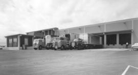
Three trucks stand ready at the loading dock of the new Shasta bottling plant in Tukwila on July 12, 1968. The trucks, from Albertson's and West Coast Grocery, are backed in, prepared to be filled with cases of bottled and canned sodas. A single gas pump is available in case the trucks need more fuel. Photograph ordered by Meltzer, Aron & Lemen, San Francisco.
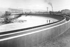
Scenes from Potlatch Forests, Inc., Lewiston, Idaho plant. Two men are walking inside the enormous open-air concrete "bowl" located on Potlatch property in Lewiston, Idaho. Others are busy putting finishing touches on the retaining walls and on what may be a conveyor system extending to the plant. Photograph ordered by Malcolm McGhie, industrial consultant, New York.
Potlatch Forests, Inc. (Lewiston, ID); Paper industry--Idaho--1960-1970; Lumber industry--Idaho--1960-1970;
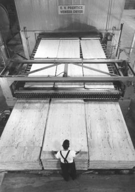
Plywood operations at Potlatch Forests, Inc., Idaho location. Glued and layered sheets of wood veneer are in the process of being processed on July 8, 1968. One worker is shown lifting a sheet of plywood into place onto one of three large stacks. Photograph ordered by Malcolm McGhie, industrial consultant, New York.
Potlatch Forests, Inc. (Lewiston, ID); Paper industry--Idaho--1960-1970; Lumber industry--Idaho--1960-1970; Plywood; Mills--Idaho--Lewiston;
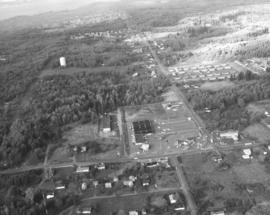
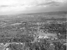
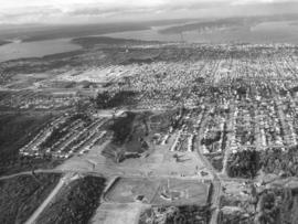
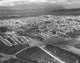
Aerials of the Northeast Tacoma - Federal Way area taken on October 30, 1968, on behalf of Puget Sound National Bank. Development is occurring in this location although there is still much forested land. Looking due north, attention is drawn to the long vertical roadway of 21st Ave. S.W. which is in Federal Way. As the road curves toward the left, it becomes 29th St. N.E. in Tacoma. When 21st Ave. splits off to the right, it becomes 356th St. S.W., again in Federal Way. A small shopping center, anchored by National Auto Parts (black roof), faces 21st Ave. S.W. Mosier's Enco Service Station, 35455 21st Ave. S.W., is directly across Blaser's Richfield Service Station on S.W. 356th St. A large water tower emerges from the woods in the upper left section of the picture.
Aerial views; Aerial photographs; Neighborhoods--Federal Way--1960-1970; Neighborhoods--Tacoma--1960-1970; National Auto Parts (Federal Way); Mosier's Enco Service Station (Federal Way); Blaser's Richfield Service Station (Federal Way); Water towers;
This aerial view of the area looking east on 29th St. N.E. was taken in late October of 1968. In the immediate foreground is the Northeast Tacoma Elementary School, 5412 - 29th St. N.E., designed by the architectural firm of Heath, Gove & Bell and built in 1919 with additions following in 1959 and 1973. The black rooftops of the small shopping center containing the National Auto Parts and Walkley's Pharmacy can be seen mid-center of the photograph. Photograph ordered by Puget Sound National Bank.
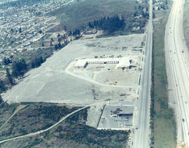
1969 Richards stock footage. Looking quite a bit different in May of 1969, the area around So. 72nd and the freeway was starting to be developed commercially. The new Rodeway Inn of America was under construction at 6802 So. Sprague, close to the freeway. Travelers could easily exit the freeway to find comfortable lodgings. A Standard Oil station was conveniently located nearby. The 130-unit luxury motor hotel opened in early November, 1969, with a 90-unit addition planned. (TNT 11-2-69, D-14)
Aerial views; Building construction--Tacoma--1960-1970; Rodeway Inn of America (Tacoma); Motels--Tacoma--1960-1970; Automobile service stations--Tacoma--1960-1970;
ca. 1969. 1969 Richards stock footage. Viewed by air in 1969, automobiles look like toys piled in heaps at the General Metals of Tacoma scrap yard on Marine View Dr. N.E. A giant crane is positioned on a pier ready to hoist the junked vehicles. General Metals had moved to a 20-acre site on the Hylebos Waterway about 1967. TPL-5902
Aerial views; General Metals of Tacoma Inc. (Tacoma); Junkyards--Tacoma; Hoisting machinery; Hylebos Waterway (Tacoma);
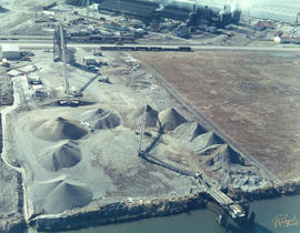
ca. 1969. 1969 Richards stock footage. Aerial look at the Glacier Sand & Gravel Co. operations in 1969. Several cone-shaped mounds of sand and/or gravel are positioned in a semi-circle at the Glacier Sand & Gravel site on Taylor Way. The sand and gravel could be delivered to the plant by either barge as the site fronted the Hylebos Waterway or by railroad cars and consequently transported out the same way.
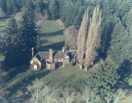
ca. 1969. 1969 Richards stock footage. Aerial view of large Tudor-styled home with landscaped grounds taken in 1969. Another view of the same property is found at D155600, image 21c. The unidentified home is nestled among large firs. It is believed to be located in the Gravelly Lake Drive area of Lakewood. Although not shown in this particular photograph, the house would have a magnificent view of a pristine lake.
This aerial view of downtown Tacoma from May of 1969 centers on the block bordered by South 12th & 13th, and Pacific & A Streets; this block was the future home of the Bank of Washington Plaza. Most of the buildings on the block have been demolished. The empty lot across Pacific (toward the bottom of the photo) will be the site of the Park Plaza South Parking Garage, 1137 Commerce Street. The parking garage was built in 1970. The two tall chimneys, top center, belong to the Tacoma Steam Plant No. 1 (to the left) and the Consumer Central Heating Company. The bridge at the right crossing the the City (now Thea Foss) Waterway is the old 15th Street Railroad Bridge. (TNT 11-20-68, p. 1)
Aerial views; National Bank of Washington (Tacoma); Banks--Tacoma; Building construction--Tacoma--1960-1970; City Waterway (Tacoma);
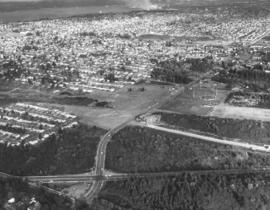
This aerial view of Tacoma looking north from South 19th Street was taken in November of 1968. The baseball field (lower center) is Heidelberg Field; the cleared land across 19th from the ball park is the future home of the Fred Meyer Department Store. ASARCO smelter's stack puffs a steady stream of smoke in upper center of photograph. Point Defiance is wooded area to the smelter's left. Photograph ordered by Morley Studios. TPL-3804
Aerial views; Neighborhoods--Tacoma--1960-1970; Heidelberg Field (Tacoma);
North end neighborhoods featuring So. 19th & Mason Sts., looking toward downtown and Tideflats. Heavily populated north end still had some sections of woods; nearly all would be eventually developed into businesses and residential housing. Ballpark in right-center is Heidelberg Field. Bare land across So. 19th from ballpark will be a shopping center eventually featuring a Fred Meyer store. So. 19th extends through the woods until it intersects with busy Hwy 16. New road is being constructed west of Heidelberg Field. Photograph ordered by Morley Studios.
Aerial views; Neighborhoods--Tacoma--1960-1970; Heidelberg Field (Tacoma);
Northwest view of north end neighborhoods around So. 19th & Mason. Ballpark on extreme right is Heidelberg Field. Area directly across ballpark on So. 19th will become a large shopping center eventually featuring Fred Meyer store. So. 19th will extend through the woods to intersect with Hwy 16. Also noted: the University of Puget Sound and its Fieldhouse are upper center on 15th & No. Warner. Photograph ordered by Morley Studios. TPL-3800
Aerial views; Neighborhoods--Tacoma--1960-1970; Heidelberg Field (Tacoma);
1969 Richards stock footage. Aerial view of No. James and 11th St. neighborhood taken during the summer of 1969. Sixth Avenue is near the top of the photograph, with Highland Hills and Swasey branch library visible. Hunt Junior High School (now Middle School), with its distinct mushroom-shaped cafeteria, is on So. 10th at the top. James St. is running diagonally into the woods from left to right; Harmon is parallel to James and on its right. No. 13th runs nearly horizontal at the bottom of the photograph; No. 11th is the small segment above it which intersects Harmon and James. The small curved portion on the left corner is the 11th & Bridgeview area. The great expanse of woods pictured above has been developed.
Aerial views; Neighborhoods--Tacoma--1960-1970; Henry F. Hunt Junior High School (Tacoma);
1969 Richards stock footage. Aerial view of 40th & Bridgeport neighborhood, featuring the University Village Shopping Center. Designed by Lyle Swedberg & Associates and built by James Kirkebo & Son, Inc., the shopping center opened in October of 1967. The main occupants were the Food King supermarket and Don's Village Drugs. Ample free parking was provided for customers who could enjoy "one-stop" shopping in the center for groceries, prescriptions, apparel, gasoline and restaurant cooking.
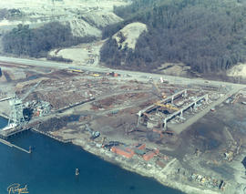
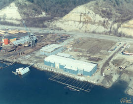
ca. 1969. 1969 Richards stock footage. Work is still continuing on Western Boat Building's new shipyard on the Hylebos Waterway in 1969. The foundations of a new dock are being laid in place in front of the main plant. The roadway behind the large seven-acre lot is Marine View Dr. N.E. Western Boat had decided to move to its new location so that larger boats could be built in their modernized plant and once the dock was completed, repairs could be done on vessels dockside. TPL-9224
Aerial views; Western Boat Building Co. (Tacoma); Boat & ship industry--Tacoma--1960-1970; Hylebos Waterway (Tacoma); Piers & wharves--Tacoma--1960-1970;
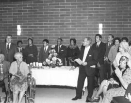
Scenes from grand opening ceremonies at senior citizen housing. City and civic leaders joined potential occupants at the dedication ceremonies of a newly completed senior citizens 77-unit apartment building located at 12th & "M" Sts. on November 24, 1968. They are pictured gathered in the building's community room that had been just been dedicated in the memory of longtime Bethlehem Baptist Church pastor, Rev. E.B. Wilson. Standing on the far left is Tacoma mayor A.L. Rasmussen. Shiloh Baptist pastor E.S.Brazill is believed to be standing in foreground holding a pamphlet. Photograph ordered by Riconoscuito Advertising. (TNT 11-24-68, B-17, D-8)
Apartment houses--Tacoma--1960-1970; Building dedications--Tacoma--1960-1970; Dedications--Tacoma--1960-1970; Mayors--Tacoma--1960-1970; Rasmussen, Albert Lawrence;
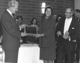
Grand opening of senior housing building. The newly completed senior citizens apartment building at So. 12th and "M" was dedicated on November 24, 1968. It was built under the sponsorship of the Tacoma Housing Authority and Senior Centers, Inc. The building's community room was named in memory of the late Rev. E.B. Wilson. For 50 years Rev. Wilson had been a member of the Bethlehem Baptist Church and its pastor for 25 of those years. Gerrit VanderEnde, chairman of the board of Pacific First Federal Savings & Loan and chairman of the Tacoma Housing Authority, smiling held one end of the plaque honoring Rev. Wilson which will hang in the community room. The woman sharing the plaque with Mr VanderEnde is believed to be one of the two daughters of the late Rev. Wilson present at the dedication, Mrs. Sadie Armstead and Mrs. Rex Jones of Seattle. The other man in the foreground is believed to be Rev. E.S. Brazill, longtime pastor of Shiloh Baptist Church. City Manager David Rowlands is standing in background at the right. Photograph ordered by Riconoscuito Advertising. (TNT 11-24-68, D-8)
Apartment houses--Tacoma--1960-1970; Building dedications--Tacoma--1960-1970; Dedications--Tacoma--1960-1970; Plaques--Tacoma; VanderEnde, Gerrit; Rowlands, David;
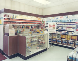
Interior- service station. Fort Lewis had a brand new service station in early 1969. The brightly lit interior had a number of products to serve automotive needs. A large sign informed customers that new AAFES consolidated procurement procedures enabled the post exchange to offer exceptional savings of quality merchandise. Shoppers were advised to look for the "gold shield" symbol on goods. Color photograph ordered by Northwest Area Exchange.
Automotive service stations--Fort Lewis; Merchandise displays--Fort Lewis; Signs (Notices);
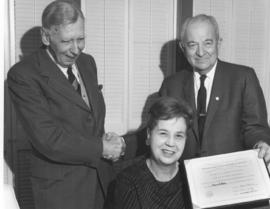
Washington State Historical Society president Reno Odlin (r) extends a warm handshake of congratulations to noted sculptor James A. Wehn on November 30, 1968, at the presentation of a plaque commemorating Mr. Wehn's selection as a David Douglas Fellow. The plaque was also signed by secretary Bruce LeRoy and given to Mr. Wehn at the Top of the Ocean. The woman in the photograph is Lillian K. Wehn, his wife. Among his many accomplishments, James Wehn created the iconic Chief Seattle statue in 1912. Photograph ordered by Washington State Historical Society.
Awards; Wehn, James A.; Odlin, Reno, 1897-1979; Washington State Historical Society (Tacoma); Wehn, Lillian K.; Shaking hands--Tacoma;
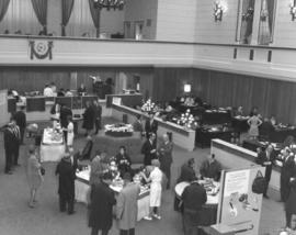
Bank of California grand reopening. A grand celebration would be held from December 11, 1968 to January 10, 1969, in the newly remodeled Bank of California building, 1011-13 Pacific Avenue. Customers and staff mingled in the banking hall on the first day of the celebration, enjoying refreshments and conducting business. New 8-foot chandeliers with Belgian glass globes would hang in the main lobby along with several side lights visible in the above December 11th photograph. Improvements to the bank would include a new drive-up teller window, walk-up teller window, two-level customer parking lot, static-free carpeting, improved lighting and expanded customer conference areas. The Bank of California was managed by Howard O. Scott. Photograph ordered by the Bank of California. (TNT full page ads 12-10-68, p. 10, 11; TNT article 12-10-68, p. 39)
Bank of California National Association (Tacoma); Banks--Tacoma;
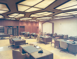
Attention is drawn to the polygon-shaped overhead lighting whose angles reflect that of one of the arched windows found in the Bank of California's trust department on November 20, 1968. The golden colored carpet and oak paneling project a sense of comfortable warmth for both employees and their customers. The Bank of California had been built in 1928 and a $600,000 remodeling project beginning in the summer of 1968 installed new carpeting, chandeliers and wall paneling but left most of the unique Italian Renaissance appearance intact. Color photograph ordered by the Bank of California.
Bank of California National Association (Tacoma); Banks--Tacoma; Office equipment & supplies; Light fixtures;
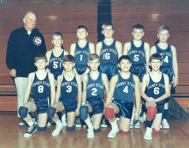
Ten boys wear the uniforms marking them as "Cheney Studs" as they pose in the Wilson High School gym on February 22, 1969. The beaming man standing next to the team is presumably their coach. Thanks to Ben Cheney's generosity, thousands of area youngsters were able to participate in amateur team sports. Color photograph ordered by the Cheney Lumber Co.
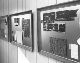
Framed floor plans and floor covering samples. The new "Westway" residential development in Federal Way had just received five manufactured homes earlier in March of 1969. The framed plans shown above including samples of floor coverings may have been been related to the new homes. Each plan showed a 3-bedroom layout, with one bath and attached carport. The buyer might have had an option of either a family room or dining room. Photograph ordered by the McMullen Marketing Associates, Bellevue.
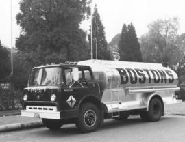
Boston's fuel truck. A new Boston's, Inc. fuel truck is parked outside Wright Park on October 24, 1968. The heavy duty Ford has a shiny oil tank with ladder attached. Boston's, Inc. was an authorized oil heat installer and a Richfield Products distributor. Radio dispatched trucks would deliver fuel oil to customers in the area. Owned and operated by Monta E. Boston, Boston's, Inc. was located at 7517 Portland Ave. Photograph ordered by Boston's, Inc.
Boston's, Inc. (Tacoma); Fuel trade--Tacoma; Ford trucks; Wright Park (Tacoma);
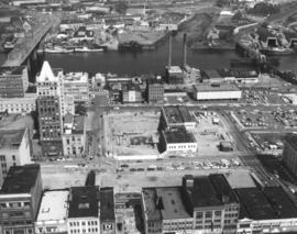
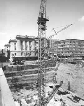
ca. 1969. 1969 Richards stock footage. This is believed to be the site of the new (National) Bank of Washington plaza in downtown Tacoma. Groundbreaking occurred on February 13, 1969, for the 22-story blockwide development. Cooney Cranes are hard at work at the excavation site located between S. 12th & S. 13th and Pacific & A Street. Rebar rods have been laid. The Federal Building, housing the main branch of the U.S. Post Office at 1102 A St., overlooks the work site.
Building construction--Tacoma--1960-1970; Banks--Tacoma; Hoisting machinery;
1969 Richards stock footage. Nearly lost in a sea of trees is Camp Six. The Camp Six Logging Museum was established in 1964 by logging engineers. Located on a 14-acre site within the Point Defiance Park, Camp Six's mission was to educate the public about the logging era with photographs, paintings, railroad and equipment displays showing how people lived and worked in the logging camps of old. A prime feature is still the Old Number 7 Shay locomotive; it had been retired May of 1964 from the Klickitat Line, the last all-steam logging railroad on the west coast. The Shay was given to Camp Six by the St. Regis Paper Co. The last section of the circular track was completed on June 2, 1969, and the train was to offer rides as soon as volunteer engineers were obtained. Tracks, ties & fittings were donated as well as money to lay rails. The Camp Six museum is staffed by volunteers and admission to the outdoor exhibits is the same in 2005 as in 1964, free. (www.camp-6-museum.org; TNT 6-2-69, p. 25)
Camp Six Logging Museum (Tacoma); Point Defiance Park (Tacoma);
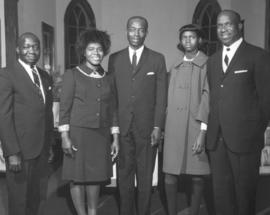
Five members of a Seventh-day Adventist Church pose for a group portrait on November 2, 1968, on the church's Sabbath. The church was located at 1310 So. L St., the former location of St. Paul's Evangelical Lutheran Church. Photograph ordered by the Tahoma Seventh-day Adventist Church.
Churches--Tacoma; Religious services--Tacoma--1960-1970;
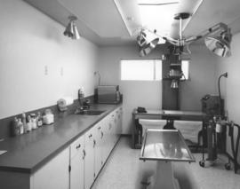
Operating room, Columbia Veterinary Clinic. Dr. Homer Webb, DVM, owned and operated the Columbia Veterinary Clinic at 5916 Sixth Ave. Dr. Webb, who had studied both at the University of Puget Sound and Washington State University, had a very modern facility. His operating room was equipped with a stainless steel examining table, diagnostic equipment including high intensity lighting, ample cabinets, a sink, and medical supplies. Dr. Webb also had a clinic in The Dalles, Oregon, where he had practiced for 18 years. (TNT ad 1-12-69, B-17)
Columbia Veterinary Clinic (Tacoma); Operating rooms--Tacoma; Veterinary hospitals--Tacoma;
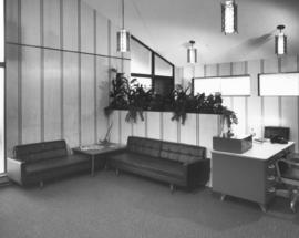
Waiting room, Columbia Veterinary Clinic. Built by Kew Construction, the Columbia Veterinary Clinic, 5916 Sixth Ave., was recently opened for business. It was owned and operated by Dr. Homer Webb, DVM. Dr. Webb had studied at the University of Puget Sound and obtained a degree in veterinary medicine from Washington State University. A look at the clinic's waiting room on January 9, 1969, shows two comfortable modern couches, a receptionist's desk, an array of plants, and abundant frosted windows. (TNT ad 1-12-69, B-17)
Columbia Veterinary Clinic (Tacoma); Waiting rooms--Tacoma--1960-1970; Veterinary hospitals--Tacoma;