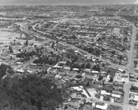
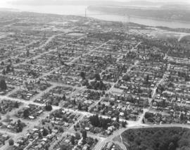
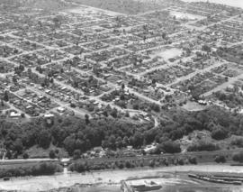
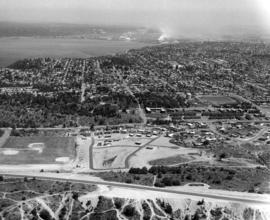
This is the Skyline district as seen by air in June of 1971. This area is close to the Narrows Bridge. Jackson Avenue is the street running horizontally. Above Jackson and making a gentle curve is Narrows; it will eventually become 26th St. To the extreme right running vertically is 17th which will become Westgate. Photograph ordered by Puget Sound National Bank.
Aerial photographs of the Skyline District taken on behalf of Puget Sound National Bank in June of 1971. Notable features included view of the Narrows, Cushman Towers, Gig Harbor (upper left corner) and Point Defiance Park (segment extending into the Narrows). The open land near bottom of photograph (not acreage with trails) has probably been developed since 1971.
Aerial views; Neighborhoods--Tacoma--1970-1980; Electric lines--Tacoma--1970-1980; Towers;
Aerial view of Pearl & Vassault Sts. in the north end in the summer of 1971. The ASARCO smelter can be seen at the top of the photograph. Pearl and Vassault Sts. run parallel horizontally near center. At 5102 North Pearl is a tall building which was the Image, a youth center, in 1971. It is now the Antique Sandwich Co. Photograph ordered by Puget Sound National Bank.
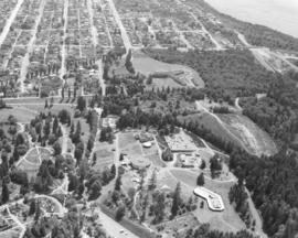
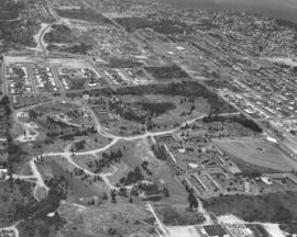
Aerial view, taken in June of 1971, of Point Defiance Park and environs. In the photograph's upper center is the Franke Tobey Jones Home and grounds. The English Tudor-styled retirement home opened in 1925 and was named after the wife of a founder of St. Paul & Tacoma Lumber Co. Mrs. Jones had donated four acres of land close to Point Defiance Park so that retirees could live with dignity in beautiful settings. The Franke Tobey Jones home is just a short distance through the trees to Point Defiance. A small portion of the 700-acre park is visible with the round Aquarium and exhibits. Photograph ordered by Puget Sound National Bank.
Aerial views; Point Defiance Park (Tacoma); Franke Tobey Jones Home (Tacoma);
North end view about North 30th St. as seen by air on June 2, 1971. Narrows Bridge near top of photograph; Cushman Towers nearby. North End water tower and reservoir at upper center. North 30th is the street that winds gently next to the reservoir. Stevens St. is horizontal line, light colored, near bottom of photograph. Mason Gulch is wooded area at right corner. Photograph ordered by Puget Sound National Bank.
Aerial views; Tacoma Narrows Bridge (Tacoma); Electric lines--Tacoma; Water towers--Tacoma; Reservoirs--Tacoma; Mason Gulch (Tacoma);
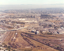
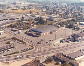
Aerial view encompassing So. 38th St., Union Ave., and South Tacoma Way on September 20, 1971. Northern Pacific shops at lower center. Reddish building with dark roof in mid-center is the Tacoma Sports Arena (formerly known as Tacoma Ice Palace). Ben's Truck Parts had taken possession of the building, purchased for $175,000, on September 20th, the date of this photo shoot. Also shown above is the new $3,000,000 Union Ave. bridge and intersection (mid-left center), part of the urban arterial street construction and 90% paid for by the State of Washington; it replaced the old 34-year-old viaduct. Large white building in big parking lot is the White Front store; Tacoma Mall Shopping Center is at far right edge. Color photograph ordered by Ben's Truck Parts. (TNT 9-3-71, p. 1 - article)
Aerial view of former Tacoma Sports Arena, recently sold to Ben's Truck Parts. It is the large building in the center of photograph with dark brown roof and reddish walls. Built in 1946, it opened as the Tacoma Ice Palace and had a 14,400 sq.ft. skating area, room enough for 500 skating couples. The Ice Palace was 279 feet long and had spans on the roof of 162-feet, second largest in the Northwest at the time. It had been the home of the (defunct) Tacoma Rockets pro hockey team, ice skating, motorcycle racing and live boxing. More recently, Roller Derby, pro wrestling, dances and flower shows had been held there. Ben's Truck Parts bought the building for $175,000 and would take possession on September 20, 1971. Color view of Tacoma Sports Arena: South Tacoma Way is street running horizontally at bottom of photograph; 38th St. is long street running vertically near left; Post Office Terminal Annex is at 38th & Warner, just above the Arena. Warner turns into Union Ave. after the intersection with 38th St. Photograph ordered by Ben's Truck Parts. (TNT 9-3-71, p. 1- article)
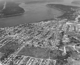
Aerial view on June 2, 1971, of Tacoma's north end. Standing tall in the trees at lower center is one of the Cushman towers. Vassault Park is positioned between Vassault and Pearl Streets in the center of the photograph. The curving roadway, intersected by both Vassault and Pearl, is the Narrows which will become North 26th St. Along North 30th, above Pearl, is the North End water tower and reservoir. Commencement Bay is at top of photograph; ASARCO smelter is along its shoreline. Photograph ordered by Puget Sound National Bank.
Aerial views; Neighborhoods--Tacoma--1970-1980; Vassault Park (Tacoma); Water towers--Tacoma; Reservoirs--Tacoma; Electric lines--Tacoma; Commencement Bay (Wash.); Smelters--Tacoma;
Aerial photograph of Burlington Northern railroad tracks around North 48th St. on June 2, 1971. The curved street through the trees that passes under the railroad tracks is North 48th St. The spurline to Ruston is in the right corner edge. Photograph ordered by Puget Sound National Bank.
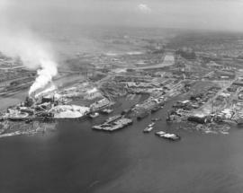
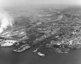
Aerial views of industrial Tideflats and waterways. On June 25, 1971, a Richards Studio photographer took a series of photographs of some of Tacoma's waterways. With Mount Rainier barely visible amidst fog, the landscape is clearer at the mouths of the waterways. From L-R are the long Puyallup Waterway, St. Paul Waterway, and Middle Waterway. Smoke is shown billowing from the St. Regis facility. Photograph ordered by Foss Tug & Barge.
Aerial views; Rainier, Mount (Wash.); Puyallup Waterway (Tacoma); St. Paul Waterway (Tacoma); Middle Waterway (Tacoma); St. Regis Paper Co. (Tacoma)--1970-1980;
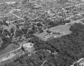
Aerial view of Franke Tobey Jones retirement home and surrounding acreage as seen by air in June of 1971. The Tudor-styled home, established in 1925 as a non-profit retirement community, is next door to Point Defiance. Due to the generosity of Mrs. Jones, whose husband was a co-founder of a major lumber concern in Tacoma, the retirement home was able to be built for $150,000. She had donated the money and also the four acres of land on which the building would stand. By 2006, the Franke Tobey Jones campus had expanded to 20 acres and included the new Garden Apartments and M.J. Wicks Family Wellness Center. Photograph ordered by Puget Sound National Bank. (www.franketobeyjones.com)
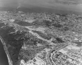
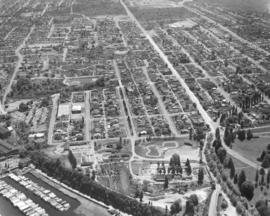
This is an aerial view in June of 1971 of the Point Defiance neighborhood. The Tacoma Yacht Club and marina are on the left corner edge. The curved track in lower center is believed to be used for go-karting. Pearl Street is the lightened long line running vertically into Point Defiance Park, a portion of which can be seen to the lower right. Road near bottom leads to the ferry dock. Photograph ordered by Puget Sound National Bank.
Aerial views; Neighborhoods--Tacoma--1970-1980; Tacoma Yacht Club (Tacoma); Point Defiance Park (Tacoma);
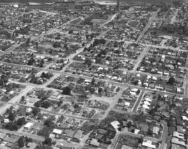
Vassault Park neighborhood in 1971. In the distance can be seen the Tacoma Tideflats with smoke stacks in full operation. Vassault Park is on the left; it lies between Vassault St. at the bottom and Pearl St. The North End tower and reservoir are center-right. No. 30th St. runs on the right of the reservoir. Photograph ordered by Puget Sound National Bank.
Aerial views; Neighborhoods--Tacoma--1970-1980; Vassault Park (Tacoma); Reservoirs--Tacoma; Water towers--Tacoma;
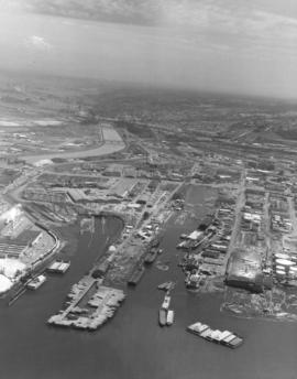
Closer view by air of various Tacoma waterways in the Tideflats. The Puyallup, St. Paul and Middle Waterways are photographed on June 25, 1971, along with assorted log dumps, oil and chemical tanks, and the bustling St. Regis Paper Co. plant, one of the region's largest employers. Photograph ordered by Foss Tug & Barge.
Aerial views; Puyallup Waterway (Tacoma); St. Paul Waterway (Tacoma); Middle Waterway (Tacoma); St. Regis Paper Co. (Tacoma)--1970-1980;
Snow capped Mount Rainier glows dimly in the background on this somewhat cloudy and/or foggy day in June of 1971. In the foreground are a portion of the Puyallup Waterway, St. Paul Waterway and Middle Waterway. On the left edge is St. Regis Paper Co. Barges floating near the mouth of the Middle Waterway are laden with chips and other materials. There are several log dumps visible. Photograph ordered by Foss Tug & Barge.
Aerial views; Rainier, Mount (Wash.); Puyallup Waterway (Tacoma); St. Paul Waterway (Tacoma); Middle Waterway (Tacoma); St. Regis Paper Co. (Tacoma)--1970-1980; Barges--Tacoma;
A series of aerial photographs were taken of the city's north end for Puget Sound National Bank in early June of 1971. This is the Pearl Street area in the north end; Pearl is the long street running rather diagonally from top to right. The North End tower, about N. 30th St., is near top. The area filled with trails may be part of the Highland Hill golf course. The drive-in with large lot is the Auto View Drive-In in the 1200 block of North Pearl; complex of buildings close by are the Polynesian Apartments.
Aerial views; Auto View Drive-In (Tacoma); Polynesian Apartments (Tacoma); Neighborhoods--Tacoma--1970-1980;
Aerial of Martinolich Shipbuilding facilities and industrial Tideflats. According to the 1971 City Directory, the shipyard was located at 1112 Alexander Avenue. This view on June 29, 1971, shows E. 11th St. intersecting with Alexander with the shipyard in the foreground. Martinolich Shipbuilding was on the Blair Waterway (formerly Port Industrial Waterway) at the site of the former Sprotsman's Marina. Anthony C. Martinolich was listed as the firm's president.
Point Defiance School and vicinity. This is the view looking east of the North 45th & Pearl St. area in June of 1971. 46th is the long street running from top to bottom on the left. 45th St. is to its right. The Point Defiance Elementary School is at 6002 North 45th with Pearl St. horizontal to the school (center of photograph). The Piggly Wiggly supermarket is at 4502 North Pearl, between 46th and 45th, with the long dark roof. Photograph ordered by Puget Sound National Bank.
Aerial views; Neighborhoods--Tacoma--1970-1980; Point Defiance School (Tacoma); Piggly Wiggly (Tacoma); Baltimore Park (Tacoma);
North 21st St. neighborhood by air. This is the north end neighborhood around North 21st St. in the summer of 1971. North 21st is the street with the power towers lower center. It lies between Orchard St. at far left and Stevens on the right. Mason Gulch is the wooded area upper center with Puget Park the other large forested space to its right. Photograph ordered by Puget Sound National Bank.
Aerial views; Neighborhoods--Tacoma--1970-1980; Puget Park (Tacoma); Mason Gulch (Tacoma);
It was a hazy day on June 2, 1971, when the above aerial view of the city's populous north end was taken by a Richards Studio photographer. The snowy tip of Mount Rainier can faintly be seen. In the photograph's foreground are Wilson High School (near bottom center) at N. 12th & Orchard. The Auto View Drive-In is close by at 1202 N. Pearl. Pearl St. intersects with Sixth Ave. and then angles off to become Bantz Blvd. Photograph ordered by Puget Sound National Bank.
Aerial views; Neighborhoods--Tacoma--1970-1980; Woodrow Wilson High School (Tacoma); Auto View Drive-In (Tacoma); Rainier, Mount (Wash.);
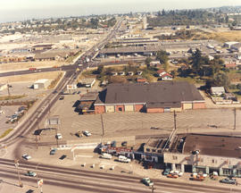
View from air of the Tacoma Sports Arena (formerly known as the Tacoma Ice Palace), 3801 South Union Avenue. Ben's Truck Parts had taken possession of the 25-year-old building on September 20, 1971. Originally built as an ice skating facility for $305,000, it was the home of the Pacific Coast League Tacoma Rockets hockey team for several years. Later usage of the Arena expanded to include live boxing events, motorcycle racing, Roller Derby, pro wrestling and dances. It was sold to Ben's Truck Parts for $175,000. Other structures of note in the above photograph include the Post Office's Terminal Annex on Warner St. and the Tacoma Mall Shopping Center at upper left corner. Color photograph ordered by Ben's Truck Parts. (TNT 9-3-71, p. 1 - article)
Aerial views; Tacoma Sports Arena (Tacoma); Tacoma Ice Palace (Tacoma); Ben's Truck Parts (Tacoma); Tacoma Mall Shopping Center (Tacoma);
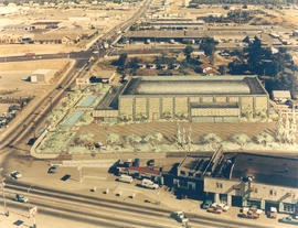
ca. 1971. Aerial view of former Tacoma Sports Arena with artist's rendering of possible architectural changes. Ben's Truck Parts had purchased the Tacoma Sports Arena (known prior as the Tacoma Ice Palace) on September 3, 1971. The company had commissioned the Richards Studio to take several aerial photographs of the Arena and vicinity. This aerial view shows possible architectural changes to the building and site with shimmering pools facing So. 38th St. and a profusion of trees and shrubs added. The exterior of the building would also change with walls apparently extended and a changed roofline. The location was easily accessible by traveling on So. 38th St. (now one of the city's busiest streets due to the close proximity to the Tacoma Mall), South Tacoma Way, and from the north, Union Ave. Color photograph ordered by Ben's Truck Parts.
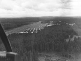
This is possibly Thun Field, just south of the City of Puyallup in the South Hill neighborhood. The air field appears to be hemmed in by tall firs. Photograph taken on January 2, 1972; ordered by Puget Sound National Bank.
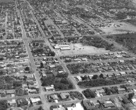
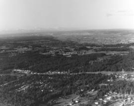
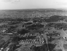
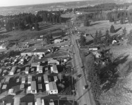
One of a series of photographs taken by air on January 2, 1972, of the Puyallup-area neighborhoods of 112th & Meridian and vicinity. Tall evergreens blanket the area with a few homes carved out of the forests. Photograph ordered by Puget Sound National Bank.
A Richards Studio photographer flew over the vicinity of 112th & Meridian on a clear January day in 1972 to take a series of photographs of this Puyallup-area neighborhood. Photograph ordered by Puget Sound National Bank.
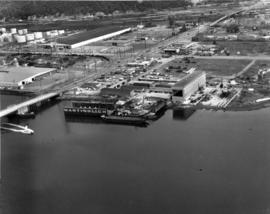
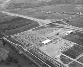
Aerial view of Kent-based Convoy Co. taken on May 1, 1972. Massive parking lot with hundreds of cars, easy access to major roadways. Railroad cars parked next to facility, many loaded with automobiles. Convoy Co. was located in Kent at 27430 - So. 72nd. Photograph ordered by the Convoy Co.
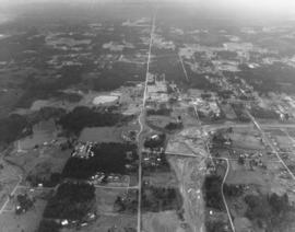
Another in a series of photographs taken by air on January 2, 1972, of the Meridian South & 112th St. neighborhoods. The landscape would change in the following years as the area started to expand. Photograph ordered by Puget Sound National Bank.
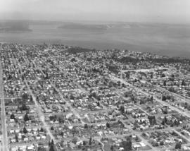
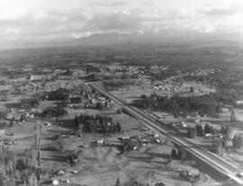
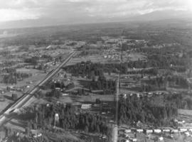
This is an aerial of roughly the future location of the South Hill Mall area in January of 1972. Running vertically in the center of the photograph is 112th St. Meridian is the street that intersects 112th. Other than the cluster of homes on the left, much of the area is still very rural and wooded. Photograph ordered by Puget Sound National Bank.
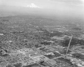
Aerial view of Puyallup Valley taken on January 2, 1972. This is roughly around the Meridian South vicinity; nestled among tall firs is a water tower visible at bottom of photograph. Photograph ordered by Puget Sound National Bank.
Aerial views; Neighborhoods--Puyallup--1970-1980; Water towers--Puyallup;