Showing 824 results

Collections
Aerial Photography With digital objects
Print preview View:

D140189-13

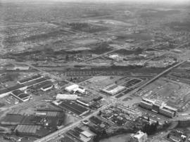
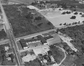
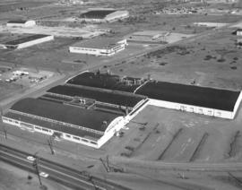
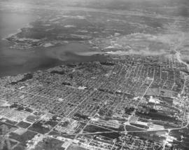
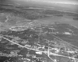
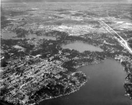
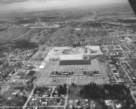
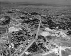
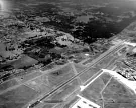
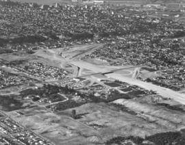
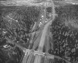
December 10, 1963, aerial view looking northeast of I-5/Gravelly Lake Dr. interchange at Ponders. This has been identified as the Nyanza Park neighborhood of Lakewood. Woods to the left of highways are the Nelson Woods; Hillcrest St. is visible within woods. Water tower is found nearby surrounded by trees. McChord Field is on the upper right; Tacoma Country & Golf Club on lower left corner. Photograph ordered by Puget Sound National Bank.


Aerial photographs; Neighborhoods--Lakewood--1960-1970; Express highways--Lakewood;

D140419-3

This aerial view of the Lakewood area and I-5 dates from December, 1963. Gravelly Lake is to the left of I-5; the southern tip of Steilacoom Lake is on the left edge of the image. As you travel northeast on I-5, by moving up the image, the Lakewood Mall can be found to the left and McChord AFB to the right. Near the top left corner a plume of smoke floats above the St. Regis Paper Co. mill on the Tacoma tideflats. (Photograph ordered by Puget Sound National Bank.)


Aerial photographs; Neighborhoods--Lakewood--1960-1970; Lake Steilacoom (Wash.); Gravelly Lake (Wash.); American Lake (Wash.); Express highways--Lakewood;

D140600-35

Richards stock footage, February, 1964. Aerial view of city's south side, including Tacoma Mall at upper center with the Bon Marche standing alone; the 2.6 million dollar Tacoma Public Utilities Center on So. 35th St. is large structure toward the right corner of photograph. Union Ave. runs parallel to the public utilities building; City Water plant/shop is believed to be on Union across from Public Utilities Center.


Aerial photographs; Tacoma Dept. of Public Utilities, Light Division (Tacoma); Shopping centers--Tacoma--1960-1970;

D140600-241

Stock footage taken on June 23, 1964, of So. 19th & Union Ave. and vicinity. The H-shaped Unionaire Apartments was just one of the many new building projects in the So. 19th & Union Ave. location in 1964. Wooded area across the street would become the Allenmore Medical Center. Tacoma Elks had started construction of their new temple at 1965 So. Union Ave. at the Allenmore Golf Course.


Aerial photographs; Unionaire Apartments (Tacoma);

D140600-173

Aerial stock footage of Washington Steel Products, Inc., plant taken on May 14, 1964. The plant was built in 1948 with additions in 1950, 1952 and a major expansion in 1953. It was located in the Tideflats at 1940 E. 11th St near Thorne Rd. Washington Steel Products was the only Northwest manufacturer of builder's hardware. By 1965 this location was listed in the City Directory as the Brown & Haley Candy Co. Distribution Division.


Aerial photographs; Washington Steel Products, Inc. (Tacoma);

D142189-6

Aerial photography looking eastward of the Port of Tacoma and industrial Tideflat areas and sections of Tacoma's north end neighborhoods. Taken in July, 1964, by request of Puget Sound National Bank. Dash Point on the upper left, various Tacoma waterways toward upper center. Bantz Blvd. (Hwy 16) at bottom; Cheney Stadium above it on the right. Tacoma Auto View Drive-in Theater is in left corner on Pearl. Wilson High School at 12th & Orchard directly above. TPL-9159


Aerial photographs; Dash Point (Wash.); Cheney Stadium (Tacoma); Woodrow Wilson High School (Tacoma);

D142189-9

There were large tracks of undeveloped land along both sides of I-5 in July of 1964 when this aerial view of Federal Way and the 348th Street interchange was taken. To the north and west, above I-5 in the picture, are Tacoma, the tideflats, Puget Sound, and both Browns Point and Dash Point. Beyond Tacoma and Puget Sound, near the top of the picture are (in no particular order), McNeil Island, Fox Island, Gig Harbor and the Key Peninsula.


Aerial photographs; Fox Island (Wash.); Express highways--Tacoma--1960-1970;

D141601-12

Aerial photographs of the Lakewood community featuring the three major lakes. Taken on a hazy day in late April, 1964, at an altitude of 5000 feet, Steilacoom, Gravelly and American lakes are shown surrounded by massive trees. Interlaaken Bridge crosses the Steilacoom Lake to the left. McChord AFB is on to right side. Ponders Corner also on the right. Tacoma Country & Golf Club is on the shores of American Lake. Photograph ordered by Puget Sound National Bank. TPL-9666


Aerial photographs; Lake Steilacoom (Wash.); American Lake (Wash.); Gravelly Lake (Wash.); Neighborhoods--Lakewood--1960-1970;

D141028-3

Aerial photograph of S.S. Tiha streaming into port at Aberdeen, Washington, in early March, 1964. Photograph ordered by Export Pacific.


Aerial photographs; Ships--Aberdeen;

D141559-1

Aerial photographs of the Villa Plaza Shopping Center and surrounding Lakewood neighborhoods were taken from a modest 2000 feet altitude on April 26, 1964. Low cloud coverage that day prevented higher elevations. Located between Gravelly Lake and Bridgeport Way in the heart of Lakewood, the large shopping center provided the convenience of one-stop shopping for its suburban clientele. The 4000-car parking lots ensured that customers did not have to hunt for parking space. View of Villa Plaza; Lost Lake on the left side of photograph. Park Lodge Elementary School, now demolished, is also on left bottom. East of Villa Plaza is the Lakeview neighborhood. Puyallup freeway is on very top. Photograph ordered by Puget Sound National Bank.


Aerial photographs; Villa Plaza Shopping Center (Lakewood); Shopping centers--Lakewood--1960-1970; Neighborhoods--Lakewood--1960-1970;

D142699-17

Overhead view of Ketron Island featuring large structure, either a hotel or luxurious residence, on September 6, 1964. This building, and others, are built on slight hillsides buffeted with trees very close to the water. The sandy beach is not very wide with driftwood piled nearby and two rowboats at the foot of the wooden bridge.


Aerial photographs; Buildings--Ketron Island; Rowboats--Ketron Island; Beaches--Ketron Island;

D142314-6

Aerial southeast view of new shopping center under construction near Ponders Corner, July, 1964. This unidentified retail center is bordered by Bridgeport Way on the bottom and Hwy. 99 near top. I-5 is at extreme top. Side road on left half of photograph is now 115th St. Ct. SW. Shopping center already has a laundry/dry cleaners, real estate firm and car wash. The large new building under construction left of the car wash is the upcoming Prairie Market; in 2006 it has been identified as now being the Happy Days Casino. The building in the lower left has been identified in 2006 as the Lakeview Light & Power headquarters; the looping line painted in the parking lot leads cars through their drive-up window. A reader has indicated that a Sound Transit station is scheduled to be built in the extreme upper left corner of the photograph. Photograph ordered by Arrowhead Estates. (Additional information provided by a reader)


Aerial photographs; Shopping centers--Lakewood--1960-1970; Building construction--Lakewood--1960-1970; Express highways--Lakewood;

D145080-2

This aerial view of the new colonial style Lakewood Motor Inn at 6125 Motor Avenue S.W. in Lakewood shows the motel as it looked on June 5, 1965, the 41-unit, deluxe inn's opening day. Located at the corner of Motor Avenue S.W. and Whitman, across from the Lakewood theater, the L-shaped, two-story complex was designed by Donald F. Burr & Associates. It featured a large courtyard with an outdoor swimming pool. Although the area around it has greatly changed, the motel is still there - now called the Best Western Lakewood Motor Inn. (Photograph ordered by Business Industry Development Service. ) (TNT 6-4-65, p. 18, TNT 6-11-65, p. 8,9)


Aerial photographs; Lakewood Motor Inn (Lakewood); Motels--Lakewood--1960-1970; Swimming pools--Lakewood;

D147400-100

1966 Richards stock footage. Aerial general view is southwest looking to the northeast. I-5/512 interchange in middle of photo. McChord Field is in lower right with planes on tarmac. Southgate neighborhood is on the left side of I-5. Large building in lower center is believed to be the Gov-Mart discount department store. Port of Tacoma is in the distance; South and East Tacoma neighborhoods compose remainder of photo. TPL-10361


Aerial photographs; McChord Field (Tacoma); Express highways--Lakewood;

D147400-18

ca. 1966. 1966 Richards stock footage. Work continues on the expansion of the Port Industrial Waterway in 1966 as men and equipment are used to extend the waterway to Lincoln Ave., a major roadway in the Tacoma industrial Tideflats area. Water now covers the land area past the Lincoln Ave. railroad bridge due to dredging. The earth is being moved to make way for ocean-going ships. The Port of Tacoma saw major growth in 1965; 96 more ships loaded and unloaded cargo at the Port docks during the first nine months of 1965 than the same time in 1964. (TNT 10-31-65, B-10; TNT 11-14-65, A-15)


Aerial photographs; Port Industrial Waterway (Tacoma);

D147400-21

1966 Richards stock footage. View from air on February 1, 1966, shows the new extension of the Port Industrial Waterway in the Tacoma Tideflats. The new cut would extend to Lincoln Ave. Working around-the-clock are General Construction Co. dredges to move the 6000-feet waterway inland. The earth was moved to make way for ocean-going ships. The project is expected to be completed in October, 1966. (TNT 10-31-65, B-10, TNT 11-14-65, A-15)


Aerial photographs; Port Industrial Waterway (Tacoma);

D147400-103

This aerial view of the Tacoma Industrial Airport (now the Tacoma Narrows Airport) on Point Fosdick, looking in a northerly direction, was taken in August of 1966, Gig Harbor is located beyond the right corner. On August 13th the airport sponsored a free air fair featuring: the Goodyear "Blimp", the Columbia; demonstrations of the TideAir "Hello Super Courier", which could take off and land within 100 feet; and a flyby by the new 141 "Starlifter" jet transport. According to an advertisement taken out by the airport and published in the News Tribune, air traffic had been increasing every month at the airport. In 1965, a total of 35,728 take-offs and landings were recorded by airline, military, and general aviation aircraft. (TNT ad, 8/12/1966 p. 12)


Aerial photographs; Tacoma Industrial Airport (Wash.); Airports;

D148857-1

June 4, 1966, aerial view of portion of Tacoma Tideflats featuring the Tidewater Oil Co. with Puget Sound Plywood plant in rear. Tidewater's winged "A" is clearly visible on one of the large storage tanks on the Tacoma plant's property. Located west of the Middle Waterway, the close proximity to water would make transport of oil products from its docks efficient. Oil could also be loaded onto trucks or by rail. Photograph ordered by Tidewater Oil Co.


Aerial photographs; Tidewater Oil Co. (Tacoma); Puget Sound Plywood, Inc. (Tacoma); Storage tanks--Tacoma; Piers & wharves--Tacoma--1960-1970;

C148862-4

ca. 1966. Copy of customer's print. Closer aerial view of the new Tacoma Mall Shopping Center ca. 1966. The Tacoma Mall had expanded to 70 stores when it opened officially in October, 1965. It touted the 7000+ parking spots available to shoppers without charge and this ca. 1966 photograph indicates that thousands would take advantage of the easy parking and climate-controlled enclosed mall. Downtown merchants and officials would try to counter with ads remarking on the variety of choices a downtown shopper would have with competition keeping prices reasonable and meter maids were even putting extra nickels into parking meters to give customers a bit more time to shop. Still, the lure of the modern roofed mall would be hard to resist for thousands of shoppers from Olympia to Seattle. View of expanded Tacoma Mall with Bon Marche on center right, J.C. Penney's in center left, National Bank of Washington circular bank building at lower left. Nordstrom-Best would be the next large company to join the mall, opening in August, 1966. Photograph ordered on June 7, 1966, by Bank of California.


Aerial photographs; Tacoma Mall Shopping Center (Tacoma); Shopping centers--Tacoma; Bon Marche (Tacoma); J.C. Penney Co. (Tacoma); National Bank of Washington (Tacoma);

D149017-8

View by air of the southern end of Fox Island. This is a closer look, taken in August, 1966, of the quiet, heavily forested island. Some islanders have chosen to build their homes with beautiful waterfront views. Photograph ordered by Swanson-McGoldrick, Inc.


Aerial photographs; Fox Island (Wash.); Forests;

D149224-5

July, 1966, aerial view of the Spanaway-McChord area. McChord AFB to the right; two planes visible on McChord Field. Lake in upper center is Spanaway Lake. The Richards photographer was supposed to take views of Frederickson as well; however, heavy smog prevented this from occurring. Photograph ordered by Puget Sound National Bank.


Aerial photographs; McChord Field (Tacoma); Spanaway Lake (Wash.);

D149142-2

Looking south on Veterans Drive S.W. in Lake City as seen by air on August 7, 1966. The wide, curving road travels past the Veterans Garage, lower-left center, and continues past the Shop-Rite Food Center, large building on left side of Veterans Drive. Lake at the top of the photograph is American Lake; two float planes are visible at the boat launch. Park close by is the American Lake North County Park. Photograph ordered by Bank of Tacoma.


Aerial photographs; Neighborhoods--Lake City; Shop-Rite Food Center (Lake City); Veterans Garage (Lake City); American Lake (Wash.);

D149404-5

Aerial view of St. Regis Paper Co. 's distribution center in Issaquah on August 11, 1966. Piles of plywood are stored both under cover and stacked neatly out in the open. The company's name is prominently displayed on the large plant roof. The new facility distributes building material supplies. Company officials indicated that the distribution center is located in an area where officials foresee high growth potential. Photograph ordered by St. Regis Paper Co. (TNT 9-4-66, A-10)


Aerial photographs; St. Regis Paper Co. (Issaquah);

A125600-41

ca. 1960. Aerials of downtown Tacoma business district. 1960 Richards stock footage shows the neatly laid out downtown streets of "A" and Pacific Avenue with many towering office buildings. Adjacent to the 11th St. Bridge is the Tacoma Building, housing the Weyerhaeuser Company, and the Perkins Building, early home of the Tacoma Daily Ledger. The Federal Building, containing the Main Post Office, is on "A" St. as well. On Pacific Avenue are the Bank of California, easily recognizable by its Ionic columns, Washington Building, and Puget Sound National Bank. The Rust Building is at 9th & Pacific.


Commercial streets--Tacoma--1960-1970; Aerial photographs;

A125600-42

ca. 1960. Downtown city streets with buildings laid out like Lego blocks in this 1960 aerial photograph taken by the Richards Studio. Primarily focuses on "A" and Pacific Avenue which contained many of the city's banks and corporation headquarters. Visible in the center of the photograph are Peoples department store and the Puget Sound National Bank headquarters. The edge of the Washington Building and the Rust Building can be seen on the left side of the picture. The Federal Building is on 11th & A Street.


Commercial streets--Tacoma--1960-1970; Aerial photographs;

A125600-22

ca. 1960. Aerial photograph of Hooker Electrochemical plant on Alexander Avenue in the Tideflats ca. 1960 Richards stock footage. Built on the site of the old Foundation shipyard, the Hooker plant opened in February, 1929. It played a leading part in Tacoma's industrial history for over sixty years. Company name was changed without comment to Occidental Chemical Corp. in 1982.


Hooker Electrochemical Co. (Tacoma); Chemical industry--Tacoma--1960-1970; Aerial photographs;

A125600-29

ca. 1960. Richards stock footage, ca. 1960. Aerial photographs of the bustling Tideflats area show businesses west of the Middle Waterway: Tidewater Oil Co., Puget Sound Plywood, Inc., and the Foss Launch & Tug Co. with several Foss tugboats docked nearby.


Puget Sound Plywood, Inc. (Tacoma); Tidewater Oil Co. (Tacoma); Foss Launch & Tug Co. (Tacoma); Aerial photographs;

A127907-5

This aerial photograph taken August 17, 1960 shows the I-5 interchange at South 38th Street. The excavation work has begun, and the 38th St. bridge over I-5 is complete. The building to the left of the cloverleaf is Langendorf Bakery, 2202 So. 38th St., which was built in 1954. The large area of cleared land at the bottom of the photograph is the future home of the Tacoma Mall. Part of downtown Tacoma and the tideflats can be seen at the top edge of the picture. Ordered by Tacoma Freeway Mart of Seattle.


Aerial photographs; Express highways--Tacoma--1960-1970;

A127907-7

Aerial photograph of south end area, including 56th St. interchange. Taken on August 17, 1960, on behalf of Tacoma Freeway Mart of Seattle. Baseball field in center is probably old Tiger Field/Cheney Field. Round structure near the baseball field is Madison School. Road traveling diagonally left to right is So. 38th St. intersecting with South Tacoma Way at the bottom.


Aerial photographs; Express highways--Tacoma--1960-1970;

D128560-2

Aerial photograph of Bethlehem Steel plant. A Richards Studio photographer in a SeaTac Helicopter flew over the Bethlehem Steel nut and bolt plant on October 12, 1960 and took several shots of the facility located at Spokane & West Marginal Way in Seattle. The large plant appears nestled in a mixed residential/industrial neighborhood with easy access to highways and water transportation. Photograph ordered by Bethlehem Pacific Coast Steel Corp.


Aerial photographs; Bethlehem Pacific Coast Steel Corp. (Seattle); Industrial facilities--Seattle;

Results 121 to 150 of 824