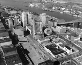
Aerial view of downtown Tacoma taken on September 4, 1968. The 11th St. Bridge spans the City (Thea Foss) Waterway to connect the business district to the more industrial Tideflats. Many of Tacoma's landmark buildings are in sight including the spire of the Puget Sound National Bank Bldg., the Tacoma Building, the Washington Building, the Rust Building and Peoples department store. The large vacant space on Pacific Ave. was slated for the Park Plaza South parking garage.
Aerial views; Aerial photographs; Business districts--Tacoma--1960-1970; Puget Sound National Bank (Tacoma); 11th Street Bridge (Tacoma); Tacoma Building (Tacoma); Washington Building (Tacoma); Rust Building (Tacoma); City Waterway (Tacoma);
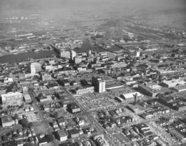
1968 Richards stock aerial footage. Closer look at primary businesses and institutions in Tacoma's commercial downtown area. Centered is the expansive County-City Building which replaced Old City Hall in 1959. On the left side is Central School's Gothic styled eight-storied building. On the right side of the County-City Building is the Tacoma Public Library. The Washington State Armory is behind the parking lot of the County-City Building. Across 11th Street from the Armory is the Tacoma Vocational-Technical School (to be renamed L.H. Bates Vocational-Technical in 1969). The Hilltop neighborhood is closer to the bottom of the photograph. 11th Street Bridge at the top of the photograph leads into the Tacoma industrial Tideflats as it provides access over the City (now Thea Foss) Waterway. Primary office buildings and banks visible near the water are the Perkins Tacoma, and Washington buildings and Puget Sound National Bank.
Aerial views; Commercial streets--Tacoma--1960-1970; County-City Building (Tacoma); Central School (Tacoma); Tacoma Public Library (Tacoma); State Armory (Tacoma); Perkins Building (Tacoma); Tacoma Building (Tacoma); City Waterway (Tacoma);
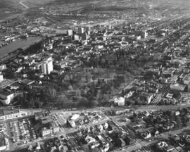
1968 Richards Stock aerial footage. Wright Park. Located near Tacoma's downtown business district, the park with its shady trees and meandering paths provided a tranquil setting for urban dwellers. Lawn bowlers took advantage of the smooth manicured playing field and in the winter, skaters would venture onto the park's frozen ponds. The glassed-in Seymour Conservatory, still in use in 2005, was filled with exotic blossoms as well as native Northwest foliage. The Greek ionic-styled First Church of Christ, Scientist, located on Division directly across from the park, was built in 1911. The City Waterway (now Thea Foss) can be seen on the upper left of the picture with part of the industrial Tideflats in view.
Aerial views; Wright Park (Tacoma); First Church of Christ, Scientist (Tacoma); City Waterway (Tacoma);
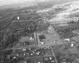
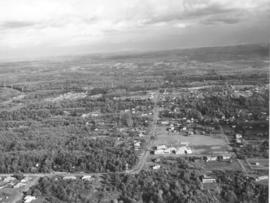
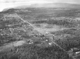
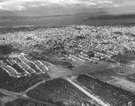
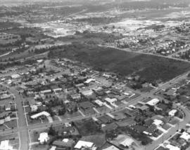
Aerials of the Northeast Tacoma - Federal Way area taken on October 30, 1968, on behalf of Puget Sound National Bank. Development is occurring in this location although there is still much forested land. Looking due north, attention is drawn to the long vertical roadway of 21st Ave. S.W. which is in Federal Way. As the road curves toward the left, it becomes 29th St. N.E. in Tacoma. When 21st Ave. splits off to the right, it becomes 356th St. S.W., again in Federal Way. A small shopping center, anchored by National Auto Parts (black roof), faces 21st Ave. S.W. Mosier's Enco Service Station, 35455 21st Ave. S.W., is directly across Blaser's Richfield Service Station on S.W. 356th St. A large water tower emerges from the woods in the upper left section of the picture.
Aerial views; Aerial photographs; Neighborhoods--Federal Way--1960-1970; Neighborhoods--Tacoma--1960-1970; National Auto Parts (Federal Way); Mosier's Enco Service Station (Federal Way); Blaser's Richfield Service Station (Federal Way); Water towers;
This aerial view of the area looking east on 29th St. N.E. was taken in late October of 1968. In the immediate foreground is the Northeast Tacoma Elementary School, 5412 - 29th St. N.E., designed by the architectural firm of Heath, Gove & Bell and built in 1919 with additions following in 1959 and 1973. The black rooftops of the small shopping center containing the National Auto Parts and Walkley's Pharmacy can be seen mid-center of the photograph. Photograph ordered by Puget Sound National Bank.
1969 Richards stock footage. Looking quite a bit different in May of 1969, the area around So. 72nd and the freeway was starting to be developed commercially. The new Rodeway Inn of America was under construction at 6802 So. Sprague, close to the freeway. Travelers could easily exit the freeway to find comfortable lodgings. A Standard Oil station was conveniently located nearby. The 130-unit luxury motor hotel opened in early November, 1969, with a 90-unit addition planned. (TNT 11-2-69, D-14)
Aerial views; Building construction--Tacoma--1960-1970; Rodeway Inn of America (Tacoma); Motels--Tacoma--1960-1970; Automobile service stations--Tacoma--1960-1970;
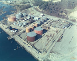
ca. 1969. 1969 Richards stock footage. Aerial view of Eastern Oil operations in 1969. Storage tanks dot the landscape of the large site on Marine View Dr. N.E. facing the Hylebos Waterway. Although tentatively identified as "Eastern Oil," it is possible that this is actually the Sound Refining Co., located on the northwest edge of the Tideflats. Sound Refining began operations in 1967 as a crude oil refinery.
Aerial views of Northeast Tacoma/Federal Way. Small section of businesses on right side includes a Richfield service station and an automotive parts store with large parking lot. This particular October, 1968, photograph focuses on a small shopping center which is actually on 21st Ave. S.W. in Federal Way. The businesses included National Auto Parts, Walkley's Pharmacy, Mosier's Enco Service Station and where 21st Ave. turns into S.W. 356th St., Blaser's Richfield Service Station. Photograph ordered by Puget Sound National Bank probably for bank expansion.
Aerial views; Aerial photographs; Neighborhoods--Tacoma--1960-1970; Neighborhoods--Federal Way--1960-1970; National Auto Parts (Federal Way); Mosier's Enco Service Station (Federal Way); Blaser's Richfield Service Station (Federal Way);
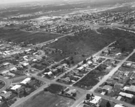
This view of northeast Tacoma near the border with King County dates from October of 1968. The road cutting through the image from top left to bottom right is 29th Street N.E. Northeast Tacoma Elementary School at 5412 29th St. N.E. is just visible near the upper left corner. Much of the area is still heavily wooded, but a small, new shopping center, featuring National Auto Parts, Walkley's Pharmacy and Mosier's Enco Service Station, is located mid-center on 21st Ave. S.W. in Federal Way.
Aerial views; Aerial photographs; Neighborhoods--Tacoma--1960-1970; Neighborhoods--Federal Way--1960-1970; Northeast Tacoma School (Tacoma); National Auto Parts (Federal Way); Mosier's Enco Service Station (Federal Way);
1969 Richards stock footage. Closer look by air at the 7-month-old Aladdin Apartments, located in the city's south end at 2112 So. 90th St. The upscale apartment complex, built by developer Oscar Hokold, was opened in September of 1968. Residents of the one and two bedroom units enjoyed such amenities as spacious bedrooms, wall-to-wall carpeting, soundproofing and dishwashers. All had views of the landscaped greens and swimming pool area.
1969 Richards stock footage. Color aerial view of Export Pacific Co. By 1969, Export Pacific's address had changed from 900 Milwaukee Way to 1942 E. 11th, next door to the Brown & Haley Distribution Division. Still headed by Chauncey L. Griggs, the firm remained in the lumber export business while sharing the address with the Export Pacific Grain Co.
Aerial views of Northeast Tacoma/Federal Way neighborhoods requested by Puget Sound National Bank. The area was still heavily wooded in October of 1968. Puget Sound National Bank may have been photographing Northeast Tacoma and adjoining Federal Way in anticipation of opening a new branch in the area. In mid-center of the photograph is a small shopping center that held the National Auto Parts store, Walkley's Pharmacy, and Mosier's Enco Service Station. It was located on 21st Ave. S.W. in Federal Way. 21st Ave. S.W. turns in one direction into 29th St. N.E. which is in Tacoma; when it turns the other way it develops into S.W. 356th St. in Federal Way.
Aerial views; Aerial photographs; Neighborhoods--Tacoma--1960-1970; Neighborhoods--Federal Way--1960-1970; National Auto Parts (Federal Way); Mosier's Enco Service Station (Federal Way);
1969 Richards stock footage. Aerial view of the Aladdin Apartments, 2112 So. 90th St., which were completed in 1968. Built by local developer Oscar Hokold, the units were all electric and rented for $135 and up. The Aladdin was centrally located, close to the freeway and mere minutes from the Tacoma Mall.
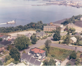
1969 Richards stock footage. Aerial view of No. 4th & D neighborhood during the summer of 1969. The Washington State Historical Society building on Stadium Way is the neo-classical structure next to Stadium Bowl. Many homes with Commencement Bay views were built in this neighborhood. A boat is seen streaming toward shore; this is believed to be the snagboat, the W.T. Preston, which was the last working sternwheeler on Puget Sound.
Aerial views; Boats--Tacoma--1960-1970; Neighborhoods--Tacoma--1960-1970; Washington State Historical Building (Tacoma); Stadium Bowl (Tacoma);
ca. 1969. 1969 Richards stock footage. Viewed by air in 1969, automobiles look like toys piled in heaps at the General Metals of Tacoma scrap yard on Marine View Dr. N.E. A giant crane is positioned on a pier ready to hoist the junked vehicles. General Metals had moved to a 20-acre site on the Hylebos Waterway about 1967. TPL-5902
Aerial views; General Metals of Tacoma Inc. (Tacoma); Junkyards--Tacoma; Hoisting machinery; Hylebos Waterway (Tacoma);
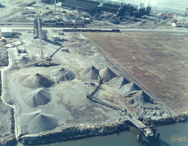
ca. 1969. 1969 Richards stock footage. Aerial look at the Glacier Sand & Gravel Co. operations in 1969. Several cone-shaped mounds of sand and/or gravel are positioned in a semi-circle at the Glacier Sand & Gravel site on Taylor Way. The sand and gravel could be delivered to the plant by either barge as the site fronted the Hylebos Waterway or by railroad cars and consequently transported out the same way.
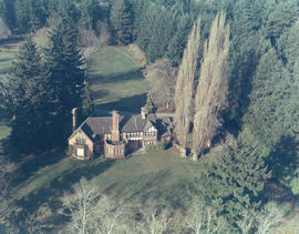
ca. 1969. 1969 Richards stock footage. Aerial view of large Tudor-styled home with landscaped grounds taken in 1969. Another view of the same property is found at D155600, image 21c. The unidentified home is nestled among large firs. It is believed to be located in the Gravelly Lake Drive area of Lakewood. Although not shown in this particular photograph, the house would have a magnificent view of a pristine lake.
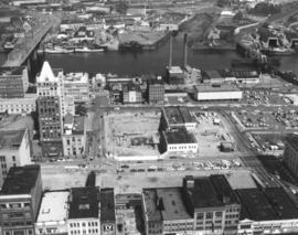
This aerial view of downtown Tacoma from May of 1969 centers on the block bordered by South 12th & 13th, and Pacific & A Streets; this block was the future home of the Bank of Washington Plaza. Most of the buildings on the block have been demolished. The empty lot across Pacific (toward the bottom of the photo) will be the site of the Park Plaza South Parking Garage, 1137 Commerce Street. The parking garage was built in 1970. The two tall chimneys, top center, belong to the Tacoma Steam Plant No. 1 (to the left) and the Consumer Central Heating Company. The bridge at the right crossing the the City (now Thea Foss) Waterway is the old 15th Street Railroad Bridge. (TNT 11-20-68, p. 1)
Aerial views; National Bank of Washington (Tacoma); Banks--Tacoma; Building construction--Tacoma--1960-1970; City Waterway (Tacoma);
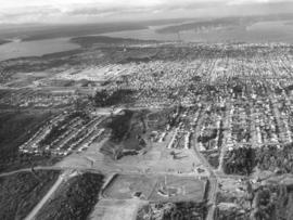
This aerial view of Tacoma looking north from South 19th Street was taken in November of 1968. The baseball field (lower center) is Heidelberg Field; the cleared land across 19th from the ball park is the future home of the Fred Meyer Department Store. ASARCO smelter's stack puffs a steady stream of smoke in upper center of photograph. Point Defiance is wooded area to the smelter's left. Photograph ordered by Morley Studios. TPL-3804
Aerial views; Neighborhoods--Tacoma--1960-1970; Heidelberg Field (Tacoma);
North end neighborhoods featuring So. 19th & Mason Sts., looking toward downtown and Tideflats. Heavily populated north end still had some sections of woods; nearly all would be eventually developed into businesses and residential housing. Ballpark in right-center is Heidelberg Field. Bare land across So. 19th from ballpark will be a shopping center eventually featuring a Fred Meyer store. So. 19th extends through the woods until it intersects with busy Hwy 16. New road is being constructed west of Heidelberg Field. Photograph ordered by Morley Studios.
Aerial views; Neighborhoods--Tacoma--1960-1970; Heidelberg Field (Tacoma);
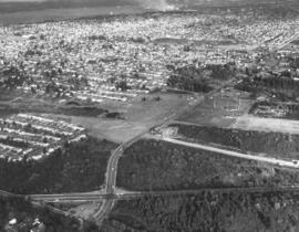
Northwest view of north end neighborhoods around So. 19th & Mason. Ballpark on extreme right is Heidelberg Field. Area directly across ballpark on So. 19th will become a large shopping center eventually featuring Fred Meyer store. So. 19th will extend through the woods to intersect with Hwy 16. Also noted: the University of Puget Sound and its Fieldhouse are upper center on 15th & No. Warner. Photograph ordered by Morley Studios. TPL-3800
Aerial views; Neighborhoods--Tacoma--1960-1970; Heidelberg Field (Tacoma);
1969 Richards stock footage. Aerial view of No. James and 11th St. neighborhood taken during the summer of 1969. Sixth Avenue is near the top of the photograph, with Highland Hills and Swasey branch library visible. Hunt Junior High School (now Middle School), with its distinct mushroom-shaped cafeteria, is on So. 10th at the top. James St. is running diagonally into the woods from left to right; Harmon is parallel to James and on its right. No. 13th runs nearly horizontal at the bottom of the photograph; No. 11th is the small segment above it which intersects Harmon and James. The small curved portion on the left corner is the 11th & Bridgeview area. The great expanse of woods pictured above has been developed.
Aerial views; Neighborhoods--Tacoma--1960-1970; Henry F. Hunt Junior High School (Tacoma);
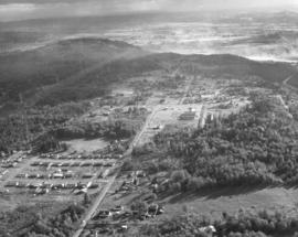
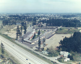
1969 Richards stock footage. Aerial view of 40th & Bridgeport neighborhood, featuring the University Village Shopping Center. Designed by Lyle Swedberg & Associates and built by James Kirkebo & Son, Inc., the shopping center opened in October of 1967. The main occupants were the Food King supermarket and Don's Village Drugs. Ample free parking was provided for customers who could enjoy "one-stop" shopping in the center for groceries, prescriptions, apparel, gasoline and restaurant cooking.
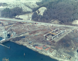
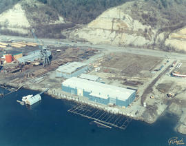
ca. 1969. 1969 Richards stock footage. Work is still continuing on Western Boat Building's new shipyard on the Hylebos Waterway in 1969. The foundations of a new dock are being laid in place in front of the main plant. The roadway behind the large seven-acre lot is Marine View Dr. N.E. Western Boat had decided to move to its new location so that larger boats could be built in their modernized plant and once the dock was completed, repairs could be done on vessels dockside. TPL-9224
Aerial views; Western Boat Building Co. (Tacoma); Boat & ship industry--Tacoma--1960-1970; Hylebos Waterway (Tacoma); Piers & wharves--Tacoma--1960-1970;
Series of aerial photographs of So. 19th & Mason neighborhoods. This view on November 8, 1968, is captured looking toward the north end neighborhoods and beyond them, eastward to the industrial Tideflats where dense smoke can be seen from many stacks. The ballpark on the right center is Heidelberg Field. Bare land across So. 19th St. from the athletic field will eventually become a shopping center. So. 19th will make its curving way to intersect with Hwy 16. A new road is being cut through woods west of the ballpark. The City of Fircrest is at lower portion of photograph. Photograph ordered by Morley Studios. TPL-3801
Aerial views; Neighborhoods--Tacoma--1960-1970; Heidelberg Field (Tacoma);
1969 Richards stock footage. Aerial 1969 views of neighborhoods around Sixth Ave. and No. 11th St. Sixth Ave. is street towards the top of the July 1, 1969, photograph; Towers Restaurant is large building near the right edge. Hunt Junior High (now Middle School) is on So. 10th with its mushroom-shaped cafeteria clearly visible. No. 11th is the street directly below the large expanse of woods; when it intersects Skyline, it turns into Bridgeview. Streets above Skyline are (top to bottom) Hawthorne, Rose and Lenore. Woods between Sixth Ave. and No. 11th have since been developed.
Aerial views; Neighborhoods--Tacoma--1960-1970; Henry F. Hunt Junior High School (Tacoma); Towers Restaurant (Tacoma);
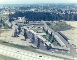
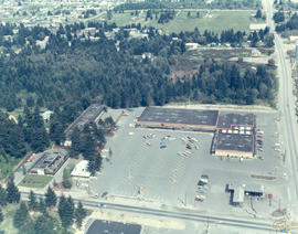
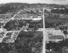
Closer look by air on April 29, 1969, of the 40th & Bridgeport Way area in University Place. 40th is the prominent road running vertically near the right side of the photograph; it is intersected by Bridgeport Way. University Place water tower is at very bottom to the left of 40th; University Village Shopping Center with large parking lot is on the right. Photograph ordered by Puget Sound National Bank.
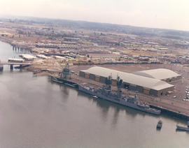
1969 Richards stock footage. View by air of new Pier 4 at the Port of Tacoma on July 1, 1969. The destroyer USS Parsons (DDG-33) is docked at pier. Long stream of people almost the length of the dock appear to be waiting to perhaps take a tour of the ship. The USS Parsons along with the battleship USS New Jersey visited Tacoma during the city's Centennial celebrations the end of June, 1969. The Parsons was a guided missile destroyer used as an anti-submarine and anti-aircraft vessel. She had sustained a minor accident while easing into Pier 4 on June 30th, smashing the pier's gangway and float. (TNT 7-1-69, p. 2)
Aerial views; Piers & wharves--Tacoma--1960-1970; Government vessels--Tacoma; Warships--Tacoma--1960-1970;
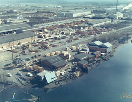
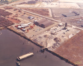
1969 Richards stock footage. Colorful aerial view of Cheney Port Mill, Inc., and Glacier Sand & Gravel located on the Tideflat's Taylor Way in the fall of 1969. The Cheney saw mill had previously been located at 501 Port of Tacoma Rd. before relocating to 3825 Taylor Way. Glacier's large lot has mounds of sand and/or gravel on the premises; there is also a conveyor system in place near the Taylor Way entrance. Glacier Sand & Gravel, 3601 Taylor Way, specialized in ready mix concrete. Both companies adjoin the Hylebos Waterway.
Aerial views; Glacier Sand & Gravel Co. (Tacoma); Cheney Port Mill, Inc. (Tacoma); Building materials industry--Tacoma--1960-1970; Lumber industry--Tacoma--1960-1970; Sawmills--Tacoma--1960-1970; Hylebos Waterway (Tacoma);
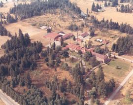
1969 Richards stock footage. Color aerial photograph of Marymount Military Academy, the only military school in Washington State; photograph taken in September of 1969. Built in 1922, the school was operated by the Dominican Sisters, a Catholic teaching order, and enrollment limited to boys 6-16. The school closed in 1976 due to insufficient enrollment and higher operating costs. In the 1980's, Harold LeMay would purchase the 80-acre property which would house much of his collection, the largest privately owned collection of automobiles in the world. Each August for the last 25 years, the LeMays have drawn thousands to the car show and open house at the former Marymount Academy. TPL-9104 (www.lemaymuseum.org)
Aerial views; Marymount Military Academy (Spanaway); Private schools--Spanaway; Military education--Spanaway;