Showing 824 results

Collections
Aerial Photography Image With digital objects
Advanced search options
Print preview View:

D155600-440C

1969 Richards stock footage. Color aerial view of Export Pacific Co. By 1969, Export Pacific's address had changed from 900 Milwaukee Way to 1942 E. 11th, next door to the Brown & Haley Distribution Division. Still headed by Chauncey L. Griggs, the firm remained in the lumber export business while sharing the address with the Export Pacific Grain Co.


Aerial views; Export Pacific Co. (Tacoma); Shipping--Tacoma--1960-1970;

D155600-213C

1969 Richards stock footage. Colorful aerial view of Cheney Port Mill, Inc., and Glacier Sand & Gravel located on the Tideflat's Taylor Way in the fall of 1969. The Cheney saw mill had previously been located at 501 Port of Tacoma Rd. before relocating to 3825 Taylor Way. Glacier's large lot has mounds of sand and/or gravel on the premises; there is also a conveyor system in place near the Taylor Way entrance. Glacier Sand & Gravel, 3601 Taylor Way, specialized in ready mix concrete. Both companies adjoin the Hylebos Waterway.


Aerial views; Glacier Sand & Gravel Co. (Tacoma); Cheney Port Mill, Inc. (Tacoma); Building materials industry--Tacoma--1960-1970; Lumber industry--Tacoma--1960-1970; Sawmills--Tacoma--1960-1970; Hylebos Waterway (Tacoma);

D155600-215C

1969 Richards stock footage. Color aerial photograph of Marymount Military Academy, the only military school in Washington State; photograph taken in September of 1969. Built in 1922, the school was operated by the Dominican Sisters, a Catholic teaching order, and enrollment limited to boys 6-16. The school closed in 1976 due to insufficient enrollment and higher operating costs. In the 1980's, Harold LeMay would purchase the 80-acre property which would house much of his collection, the largest privately owned collection of automobiles in the world. Each August for the last 25 years, the LeMays have drawn thousands to the car show and open house at the former Marymount Academy. TPL-9104 (www.lemaymuseum.org)


Aerial views; Marymount Military Academy (Spanaway); Private schools--Spanaway; Military education--Spanaway;

D155048-1

Aerial photograph, looking west, of So. 19th & Mason neighborhood taken on November 8, 1968. Ballpark with lights on the left corner is Heidelberg Field. Land under development across the street from the ballpark is where the Fred Meyer Shopping Center eventually will be built. Glimpse of the Narrows Bridge on far upper portion of photograph. Photograph ordered by Morley Studios.


Aerial views; Neighborhoods--Tacoma--1960-1970; Heidelberg Field (Tacoma);

D155048-2

Aerial view of So. 19th & Mason neighborhood looking north toward Point Defiance. Gig Harbor area on upper left. Although the North end was heavily populated, there are still wooded areas remaining in late 1968. Ballpark is Heidelberg Field on So. 19th and Mason. Land directly across the street is being developed for a shopping center eventually featuring Fred Meyer. Street name would change to Stevens once it crosses So. 19th St.; wooded area across Stevens from future shopping center will later become apartments. Photograph ordered by Morley Studios. TPL-3803


Aerial views; Neighborhoods--Tacoma--1960-1970; Heidelberg Field (Tacoma);

D155600-361C

1969 Richards stock footage. Aerial view of Tacoma's north end featuring the No. 4th & D St. neighborhood. The Washington State Historical Building is located high above its neighbor, the Stadium Bowl, near the center of the photograph. The French Chateau-styled Stadium High School is on the extreme right edge of photograph.


Aerial views; Neighborhoods--Tacoma--1960-1970; Washington State Historical Building (Tacoma); Stadium Bowl (Tacoma); Stadium High School (Tacoma);

D155750-6

This is the Menlo Park and Sunset Beach area. Gravelly Lake Dr. is believed to be the road running horizontally surrounded by trees and homes. April, 1969, aerial views of the University Place area requested by Puget Sound National Bank. TPL-9241


Aerial views; Neighborhoods--University Place;

D155600-216C

1969 Richards stock footage. Parkland neighborhood featuring Pacific Lutheran University, Garfield St. and Pacific Avenue as viewed by air in September of 1969. Fall has come to the Pacific Northwest as yards have browned and the trees other than the numerous firs will soon lose their leaves. Looking west from Pacific Ave near the bottom of the photograph is the neighborhood around Pacific Lutheran University. Piggly Wiggly has a supermarket which is at the intersection of Garfield and Pacific; its large letters are clearly visible from the air. To the grocery store's right is believed to be Parkland Lutheran Church & School with its playground behind it. Pacific Lutheran University's upper campus buildings, surrounded by tall firs, are clustered in the center of the picture. Portions of McChord AFB can hazily been seen at the top of the photograph.


Aerial views; Pacific Lutheran University (Parkland)--1960-1970; Neighborhoods--Parkland; Piggly Wiggly (Parkland);

D155041-4C

November, 1968, aerial view of U.S. Oil & Refining plant on Tideflats. Petroleum storage tanks dot the landscape, part of the 120-acre plot owned by the U.S. Oil & Refining Co. The plant was built on land just south of Lincoln Ave. Closest waterway would be the Port Industrial Waterway. Photograph ordered by U.S. Oil & Refining.


Aerial views; Petroleum industry--Tacoma--1960-1970; US Oil & Refining Co. (Tacoma); Storage tanks--Tacoma;

D155600-236

ca. 1969. 1969 Richards stock footage. Burlington Northern line. View looking north of railroad tracks and Bayside Drive next to Commencement Bay. Bayside Drive would change its name to Ruston Way at the Old Town Dock near the top of the photograph. Eventually, Bayside would be absorbed and made wider by becoming Schuster Parkway. Famous restaurant Top of the Ocean near top of photograph; it would be destroyed by fire in April of 1977.


Aerial views; Railroad tracks--Tacoma--1960-1970; Top of the Ocean (Tacoma);

D155600-242

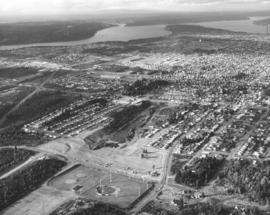
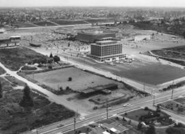
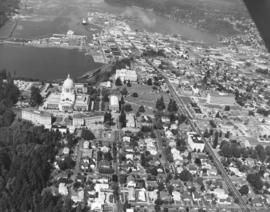
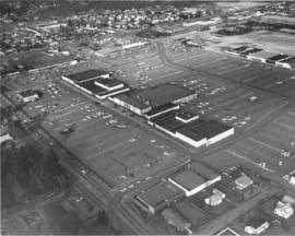
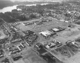
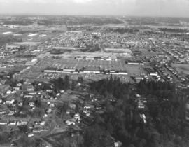
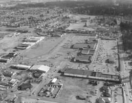
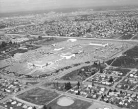
1969 Richards stock footage. View by air of the Tacoma Mall Shopping Center and newly built Tacoma Mall Office Building on July 1, 1969. A new addition to the Tacoma Mall Shopping Center was the 6-story Tacoma Mall Office Building, 4301 So. Pine. Designed by Olympia architects Bennett & Johnson and built by Cascade-Olympic Construction, the 2.7 million dollar structure was one of the first new major office buildings to be built in Tacoma in many years. The building was 90,000 square feet of reinforced concrete and came equipped with soundproof walls and air conditioning. Three high-speed elevators could be utilized to transport quickly customers and staff alike. The large lot provided plenty of free parking. It was conveniently located just off Pine St. and like the rest of the mall, freeway access was close by. The Tacoma Mall Office Building is still in service 36 years after its grand opening in March of 1969. Also shown above are the major stores of the Tacoma Mall: the Bon Marche, Nordstrom Best, and J.C. Penney. (TNT 8-4-68, A-11, TNT 10-27-68, B-11)


Aerial views; Tacoma Mall Office Building (Tacoma); Office buildings--Tacoma--1960-1970; Tacoma Mall Shopping Center (Tacoma); Shopping centers--Tacoma; Bon Marche (Tacoma); Nordstrom Best (Tacoma); J.C. Penney Co. (Tacoma);

D155041-10

ca. 1974. This aerial view of U.S. Oil & Refining Co. land was taken possibly on October 2, 1974. The company owned 120 acres south of Lincoln Avenue in the industrial Tideflats. A glimpse of Mount Rainier can be hazily seen in the background. Photograph ordered by U.S. Oil & Refining Co.


Aerial views; US Oil & Refining Co. (Tacoma);

D155600-355C

1969 Richards stock footage. Aerial look at newer Western Boat Building plant on Hylebos Waterway. The shipbuilding firm had moved to a seven-acre site on Marine View Dr., vacating the temporary quarters at the Port Industrial Yard it had occupied since fire destroyed their longtime plant on 11th St. One boat is under construction at far right edge of photograph.


Aerial views; Western Boat Building Co. (Tacoma); Boat & ship industry--Tacoma--1960-1970; Boats--Tacoma--1960-1970; Hylebos Waterway (Tacoma);

D156904-5

State capitol and grounds. Aerial view looking north on September 5, 1969, of the City of Olympia focusing on the domed Legislative Building and surrounding grounds. Body of water is Capitol Lake. Neatly lined streets are a blend of businesses and large homes. Long road east of the capitol grounds is Capitol Way. Sylvester Park is clump of woods adjacent to Capitol Way. Photograph requested by Puget Sound National Bank.


Aerial views; Streets--Olympia--1960-1970; Legislative Building (Olympia); Capitol Lake (Olympia);

D156021-3

1969 Aerial view of the Villa Plaza Shopping Center. Prior to the construction of the massive Tacoma Mall, there was the Villa Plaza Shopping Center in Lakewood. The Villa Plaza was built in 1957 on the site of the former 200-acre Visitation Villa. By the mid-50's, Lakewood was growing in leaps and bounds and there was a need for more convenient shopping in the suburbs. The Villa Plaza was not the first "one-stop" shopping center in the area--that honor would go to the Lakewood Center--but it had more room for development and most importantly, plenty of free parking. Ads for the Villa Plaza constantly promoted the availability of its 4000 car parking lot. Major downtown stores J.C. Penney, Woolworth and Rhodes would open branches in the Villa Plaza, therefore lessening the necessity of suburban shoppers to venture downtown. Unlike the Tacoma Mall, which would open in 1965, the Villa Plaza was not contained under one roof although many stores were clustered within short walking distances. Photograph ordered by Puget Sound National Bank.


Aerial views; Villa Plaza Shopping Center (Lakewood); Shopping centers--Lakewood--1960-1970;

D156021-8

Aerial view of the Villa Plaza Shopping Center and surrounding Lakewood neighborhoods on February 26, 1969. Steilacoom Lake is in the background. St. Francis Cabrini Catholic Church property near left bottom corner. Tenzler Library (now Lakewood Library) close to Gravelly Lake Dr. on extreme left edge. Photograph ordered by Puget Sound National Bank.


Aerial views; Villa Plaza Shopping Center (Lakewood); Shopping centers--Lakewood--1960-1970; Lake Steilacoom (Wash.); Neighborhoods--Lakewood--1960-1970;

D156021-4

View by plane of Villa Plaza Shopping Center and surrounding Lakewood neighborhoods on February 26, 1969. The Villa Plaza's 4000-car parking lot and congregation of large stores were major attractions. In 1969, the shopping center was twelve years old and facing competition from the younger Tacoma Mall Shopping Center. There was still room for expansion for the Lakewood facility but it lacked direct freeway access that the Tacoma Mall enjoyed. Photograph ordered by Puget Sound National Bank.


Aerial views; Villa Plaza Shopping Center (Lakewood); Shopping centers--Lakewood--1960-1970; Neighborhoods--Lakewood--1960-1970;

D156021-6

Another aerial view in a series of photographs of Lakewood's Villa Plaza Shopping Center taken on February 26, 1969. A McDonald's restaurant has sprouted up near an entrance to the large shopping center. A notable feature of the Villa Plaza is the immense parking lot, capable of holding 4000 cars. Customers could choose to park their vehicles near any of the 30+ stores and not worry about feeding the meter. Photograph ordered by Puget Sound National Bank.


Aerial views; Villa Plaza Shopping Center (Lakewood); Shopping centers--Lakewood--1960-1970; Parking lots--Lakewood; McDonald's (Lakewood);

C162499-1

ca. 1972. Copy of customer print, ordered by law firm of Murray, Scott & McGavick on October 16, 1972. This is an aerial of the Gig Harbor area with various streets and company names written in. It appears that future construction of on and off-ramps and an overpass will impact housing and businesses already present. This is in the vicinity of Wollochet Gig Harbor Road.


Aerial views; Maps;

D163000-114C

ca. 1973. 1973 Richards stock footage. Closer aerial look at shipyard on the Hylebos Waterway, believed to be Tacoma Boatbuilding who had constructed a $3,000,000 plant there after the disastrous fire of 1968 which had destroyed their Sitcum Waterway facility. The Hylebos location now provided 20 acres of space and held separate buildings for aluminum fabricating, steel fabricating, administrative and engineering, and warehouse for equipment. Several boats are pictured above docked at the 300-foot pier. TPL-6583


Aerial views; Boat & ship industry--Tacoma--1970-1980; Tacoma Boat Building Co., Inc. (Tacoma); Hylebos Waterway (Tacoma); Logs; Piers & wharves--Tacoma--1970-1980;

D163161-3

One of a series of photographs taken on behalf of Collison Realty by the Richards Studio on April 3, 1973. These aerial views focused on the 112th & Meridian neighborhood. Eventually, the South Hill Mall would be built in this area.


Aerial views; Neighborhoods--Puyallup--1970-1980;

D163162-5

The focus of this April, 1973, aerial is the Tacoma Mall Shopping Center and its environs. Located in the city's south end, the Tacoma Mall enjoyed easy access from the freeway and acres of free parking space. Customers could choose from about 100 stores, all under one climate-controlled roof. Rhodes Bros. would be the next large department store to open in the newly expanded Mall, a move that would eventually mean the closing of its flagship downtown location in late 1974. This view, looking east, also shows South Tacoma Way at the bottom. Photograph ordered by Puget Sound National Bank.


Aerial views; Neighborhoods--Tacoma--1970-1980; Tacoma Mall Shopping Center (Tacoma); Shopping centers--Tacoma--1970-1980; Express highways--Tacoma--1970-1980;

D163162-13

Northwest view from South 84th & Park Ave. This aerial look at Tacoma's south side was taken on behalf of Puget Sound National Bank on April 2, 1973. Lake in the center is Wapato Lake, bordered by South Alaska, South 72nd and Sheridan Ave. John S. Baker Junior High (now Middle School) is near bottom-center. Park Ave. has been marked in ink. Yakima Ave. is parallel to Park and is left of Park.


Aerial views; Neighborhoods--Tacoma--1970-1980; Wapato Lake (Tacoma); Baker Junior High School (Tacoma);

D163000-105C

ca. 1973. 1973 Richards stock footage. This may be the 712-foot long tanker, "Achilles," as seen by air, docked at the Port of Tacoma in 1973. She appears to be ready to take on grain from the port's grain elevator. Other unidentified vessels are in the background.


Aerial views; Vessels; Piers & wharves--Tacoma--1970-1980;

D164908-1C

Aerial of Kaiser Aluminum plant as viewed on June 10, 1974. Smoke drifts from the 500-foot stack near the aluminum rod mill. 32 years later in July of 2006, the smokestack was demolished in front of hundreds of fascinated spectators. Color photograph ordered by Kaiser Aluminum.


Aerial photographs; Kaiser Aluminum & Chemical Corp. (Tacoma); Industrial facilities--Tacoma--1970-1980; Aluminum industry--Tacoma--1970-1980;

D164600-101

1974 Richards stock footage. Aerial view of the Tacoma Mall and surrounding south end neighborhoods. This May, 1974, view by air makes it plain that one of the main attributes of this popular shopping center was its ready access by freeway and its enormous free parking lots. Should a visitor to the Mall decide to bypass the freeway, the Mall would still be accessible through well traveled local streets such as Pine, South 38th and South 48th. The Mall had opened its west end addition in July of 1973 to add 20 more stores to the shopping center; in May of 1974, construction was proceeding rapidly with the new Liberty House/Rhodes department store at the far west end of the shopping center. TPL-5876


Aerial views; Aerial photographs; Tacoma Mall Shopping Center (Tacoma); Shopping centers--Tacoma--1970-1980; Express highways--Tacoma--1970-1980; Neighborhoods--Tacoma--1970-1980;

D165802-12

A series of aerial photographs were taken on March 27, 1975, on behalf of Puget Sound National Bank of the area between 320th in Federal Way, North Puyallup, Pacific Highway South and Valley Ave. The purpose for the photographs was not expressed in Richard studio notes but it is possible that the bank was preparing for the later acquisition of banks in the vicinity.


Aerial views;

D165802-5

A series of photographs were taken on March 27, 1975, on behalf of Puget Sound National Bank of the area between 320th in Federal Way, North Puyallup, Pacific Highway and Valley Ave. These aerial views of thirty years past show relatively undeveloped areas with little traffic.


Aerial views;

D165802-48

Aerial view, taken in March of 1975, of communities interspersed among large sections of firs. According to Richard Studio notes, the firm had been requested to take a series of photographs of the region between 320th in Federal Way, North Puyallup, Pacific Highway South and Valley Ave. for Puget Sound National Bank.


Aerial views; Firs;

D165802-6

Aerial view of heavily wooded lands possibly in the North Puyallup/Valley Ave location. This view has undoubtedly changed in the 32 years since the photograph was taken on behalf of Puget Sound National Bank.


Aerial views; Firs;

Results 151 to 180 of 824