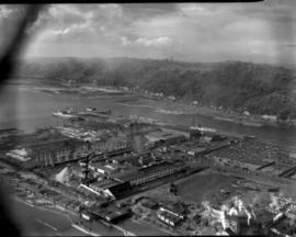
Copy of customer's print. The Port of Tacoma Industrial area is seen in an aerial view in a photograph copied for Howard R. Smith. Mr. Smith, a well-known Tacoma businessman, had been president of the Tacoma Athletic Commission and involved in advertising for many years. The photograph was copied on August 27, 1954; actual date of print is unknown. Log dumps for various lumber concerns are clearly visible to the picture's right.
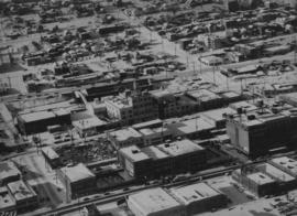
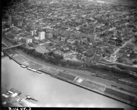
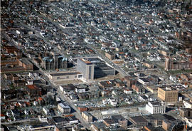
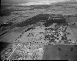
ca. 1949. Aerial view, believed to have been taken in December of 1949, of downtown business district featuring Columbia Breweries (center) on South "C" Street where the sprawling plant covered 3-4 acres. Snow is gradually melting over the rooftops on this sunny winter day. The Hunt & Mottet Co. building is at the right foreground.
Aerial views; Aerial photographs; Columbia Breweries, Inc. (Tacoma)--1940-1950; Brewing industry--Tacoma--1940-1950; Hunt & Mottet Co. (Tacoma); Commercial streets--Tacoma--1940-1950;
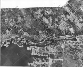
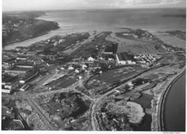
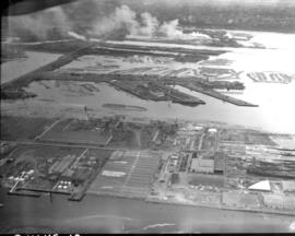
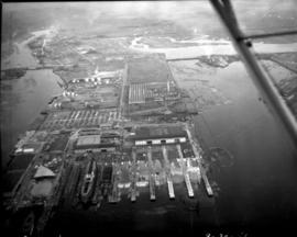
Aerial view of the Port of Tacoma, for Cheney Lumber Co. The Port Piers and the Naval Station, with mothballed fleet, can be seen. There were 25 mothballed escort carriers under the care of the Tacoma Group, Pacific Reserve Fleet. The ships were serviced and kept in readiness for war. The Hylebos Waterway can be clearly see all the way to the turning basin. The roads appear as clear white lines. TPL-2261
Aerial photographs; Bays--Washington (State); Commencement Bay (Wash.); Port of Tacoma (Tacoma)--1950-1960;
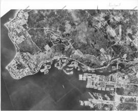
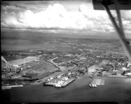
Aerial view of the Port of Tacoma, for Cheney Lumber Co. Port Piers, Naval Station (with mothballed fleet) and Hylebos Waterway can be clearly seen. Photo continues around Browns Point and on to Dash Point. Roads appear as clear white lines. TPL-2262
Aerial photographs; Bays--Washington (State); Commencement Bay (Wash.); Port of Tacoma (Tacoma)--1950-1960;
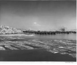
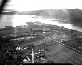
A rare early snowfall blankets the earth in this aerial shot of the Hylebos Waterway in October of 1956. Log booms float in the water and part of the mothballed fleet of escort carriers, kept in readiness under the care of the Tacoma Group, Pacific Reserve Fleet, can be seen. Mt. Rainier is partially obscured by haze and smoke rising from the industrial sites on the Tideflats.
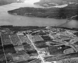
This aerial view of Tacoma's West End and the Tacoma Narrows Bridge was taken in March of 1957. 6th Avenue cuts upward through the center of the picture curving to the right as it feeds onto the Narrows Bridge. The road starting at the bottom right and running into 6th Ave. is Pearl Street, with the Tacoma Auto View Theater, 1202 North Pearl near the right edge. The buildings at the corner of 6th and Pearl are the early Highland Hills Shopping Center, 5915 6th Ave.. The bare land just above and to the right of the Auto View became the Highland Hills Golf Course.
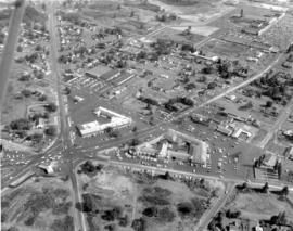
Lakewood Center as pictured by air in August of 1957. Located near the busy streets of Bridgeport Way and Gravelly Lake Dr., the Lakewood Center was among the first of the nation's one-stop shopping centers. It underwent several expansions including a major addition in 1955 when the modified Colonial, shown above with an "open" triangular side, opened with fourteen new businesses. The shopping center was 15 minutes from downtown Tacoma, five minutes from McChord and ten from Fort Lewis. It provided an alternative shopping area for residents in the communities outside Tacoma city limits with the added attraction of more parking than in downtown Tacoma.
Aerial photographs; Lakewood Community Center (Lakewood); Shopping centers--Lakewood--1950-1960;
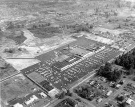
Aerial view of the Villa Plaza Shopping Center taken for its opening in August of 1957. One thing was clear: there was plenty of parking available for shoppers at Lakewood's newest shopping center, the Villa Plaza, and plenty of room for expansion if necessary. The Villa Plaza heavily advertised its free 4000-car parking lot and the convenience of many stores side-by-side including familiar names J.C. Penney's, Woolworth's and Rhodes Brothers. Acknowledging the buying power of suburbanites, these major department stores left their flagship operations downtown but garnered new shopping dollars by opening branches outside city limits. The Villa Plaza, like the older Lakewood Center, was closer to McChord and Fort Lewis than downtown.
Aerial views; Aerial photographs; Villa Plaza Shopping Center (Lakewood); Shopping centers--Lakewood--1950-1960; Parking lots--Lakewood;
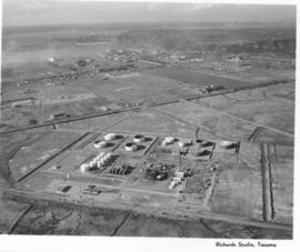
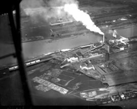
Aerial photographs- U.S. Oil Refinery. Aerial photographs of the U.S. Oil refinery were taken on October 3, 1957. The petroleum "tank farm" was located on an 120 acre site in the Tideflats. The light colored round cylinders shown in the photograph are probably the storage tanks. The refinery would be close to both rail and water transport. Photograph ordered by U.S. Oil & Refining Co.
Aerial photographs; Storage tanks--Tacoma; US Oil & Refining Co. (Tacoma);
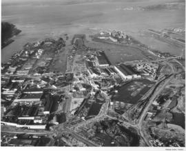
This was how Tacoma's Tideflats appeared from the air on January 3, 1958. The area was crowded with pulp and paper mills, lumber yards, log ponds and warehouses. Tacoma's easy access to rail and water made the transport of industrial and wood products a simpler process. View of, left to right, the City, Middle, St. Paul and Puyallup Waterways. The St. Regis plant was located on the finger between the Puyallup and St. Paul waterways in the buildings with the "L" shape. The St. Paul & Tacoma Lumber sawmill and buildings were close by, at the rear of the waterway in the loaf shaped buildings. In August 1957, St. Paul became an operating subsidiary of the St. Regis Paper Co. Photograph ordered by Malcolm McGhie.
Aerial photographs; St. Regis Paper Co. (Tacoma)--1950-1960; St. Paul & Tacoma Lumber Co. (Tacoma);
Additional aerial photographs of the Tideflats area were requested by Malcolm McGhie and taken on January 3, 1958. Earlier photographs were taken about a month prior. Dash Point can be spotted protruding into the bay on the right with Vashon Island at the top of the photograph. St. Paul & Tacoma Lumber Co., who in August, 1957, became a subsidiary of St. Regis Paper Co., can be clearly seen towards the middle of the photograph including its loaf-shaped buildings. Its sawmill had provided 35% of the pulp mill's wood requirements. St. Regis is adjacent to its new subsidiary and to the upper right. The City Waterway is the body of water to the extreme left; new developments, with the removal of warehouses, shipbuilding, and mills nearly 45 years later have changed its landscape and revitalized the area.
Aerial photographs; St. Paul & Tacoma Lumber Co. (Tacoma); St. Regis Paper Co. (Tacoma)--1950-1960;
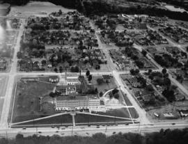
This aerial view of the Pierce County Hospital and its surrounding neighborhood was taken in July of 1941. The hospital's new north wing and new west wing were nearing completion. An extra three-mil tax levy was passed in March of 1940 to fund the expansion of the hospital. At the upper left corner is the excavation for the Lincoln Bowl, which was not completed until after WWII. Pierce County took over ownership of the hospital in 2000. (T.Times 7/31/1941 p.5)
Aerial photographs; Pierce County Hospital (Tacoma); Neighborhoods--Tacoma--1940-1950;
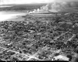
Aerial view of industrial section of Tacoma taken on July 20, 1941. The business district of downtown Tacoma is in the distance. Various log dumps dot the waterways in the foreground.
1941 Aerial view of Sea-Tac Shipyard with Peterman Manufacturing Company in foreground, looking west. The Peterman Co. manufactured fir doors and veneer panels. It was forced to vacate the property in June of the following year as the Shipyard needed space to build the many ships under contract.
Aerial view of downtown Tacoma including waterfront warehouses and half-moon railroad yards. This July of 1941 photograph, looking westward, shows the densely packed business districts of Tacoma as well as outlying residential areas. The waterway is the City (now Thea Foss) Waterway with the 11th St. Bridge (now Murray Morgan Bridge) in view.
Aerial views; Aerial photographs; Cityscapes; City Waterway (Tacoma); Business districts--Tacoma--1940-1950; Commercial streets--Tacoma--1940-1950;
Aerial view of Sea-Tac Shipyard taken on July 20, 1941. Even before the U.S. entered WWII, the Seattle-Tacoma Shipyard was busy with building tankers and C-3 freighters for the government.
1941 Aerial view of downtown Tacoma showing the Central Business District, Port/Industrial, and Central residential areas. The 11th St. Bridge (now Murray Morgan Bridge) leads traffic over the City (now Thea Foss) Waterway over to the industrial Tideflats.
Aerial views; Aerial photographs; Cityscapes; City Waterway (Tacoma); Business districts--Tacoma--1940-1950; Commercial streets--Tacoma--1940-1950; 11th Street Bridge (Tacoma);
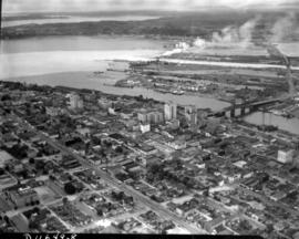
Aerial view of downtown Tacoma showing Central Business District and Port/Industrial areas. This view, looking east toward the bustling industrial Tideflats, was taken on July 20, 1941.
Aerial views; Aerial photographs; Cityscapes; Business districts--Tacoma--1940-1950; Commercial streets--Tacoma--1940-1950;
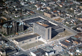
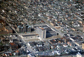
ca. 1958. Aerial view of newly built County-City Building, 930 Tacoma Avenue South, circa 1958, and surrounding neighborhood. The building would be dedicated in April of 1959. Directly behind its left wing is the venerable Pierce County Courthouse, 1012 South "G" St., soon to be demolished and ground transformed into parking for the County-City Building. At left lower corner is the Tacoma Public Library, 1102 Tacoma Avenue South.
Aerial views; Aerial photographs; County-City Building (Tacoma); Pierce County Courthouse (Tacoma); Tacoma Public Library (Tacoma); Streets--Tacoma--1950-1960; Commercial streets--Tacoma--1950-1960;
ca. 1958. Aerial view of the neighborhood around Tacoma Avenue South near the new County-City Building circa 1958. In the center is the County-City Building, with its two wings and tower at 930 Tacoma Avenue South, built to replace the deteriorating Pierce County Courthouse immediately to its rear. The Romanesque old Courthouse at 1012 South "G" would be demolished and the area used as a parking lot. At left center is the Tacoma Public Library, 1102 Tacoma Avenue South. The Central School, 601 South 8th, is at right center edge but McDonald's is yet to be built next door on Tacoma Avenue South.
Aerial views; Aerial photographs; Cityscapes--Tacoma--1950-1960; County-City Building (Tacoma); Pierce County Courthouse (Tacoma); Tacoma Public Library (Tacoma); Central School (Tacoma); Streets--Tacoma--1950-1960;
ca. 1958. This aerial view is looking west with focus upon the newly built County-City Building at 930 Tacoma Avenue South, circa 1958. The venerable Pierce County Courthouse, directly behind one of the County-City Building wings, was in poor shape and after much discussion, it was decided to build a new structure to replace it. Site preparation and excavation began in 1955 but the building would not be completed until 1959. Also in view are the Tacoma Public Library, directly across the street at 1102 Tacoma Avenue South, and the State Armory at 715 South 11th, behind the Pierce County Courthouse.
Aerial views; Aerial photographs; County-City Building (Tacoma); Pierce County Courthouse (Tacoma); Tacoma Public Library (Tacoma); State Armory (Tacoma); Commercial streets--Tacoma--1950-1960; Streets--Tacoma--1950-1960;
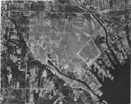
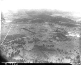
Aerial view of Northern Pacific Rail property at Lakeview which was taken on August 22, 1941. Land is dotted with trees in foreground with thicker forests toward the top of the photograph. Few, if any, homes in sight. Ordered by Raleigh -Hayward Company.
Aerial view of Northern Pacific property at Lakeview. Closer view of land seen in D11794, image 1. This time buildings can faintly be seen in this photograph taken on August 22, 1941. Part of series ordered by Raleigh-Hayward Company.
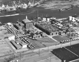
ca. 1960. Richards stock footage. Aerial photograph taken in 1960 of the Hooker Electrochemical Co. plant located at 605 Alexander Avenue on the Tacoma Tideflats. A ship is docked at the company dock on the Hylebos Waterway, ready to transport and transfer Hooker products. A railroad spur running through the facility also made transportation of Hooker chemicals an easier task.
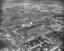
Aerial photograph of Bethlehem Steel plant. A Richards Studio photographer in a SeaTac Helicopter flew over the Bethlehem Steel nut and bolt plant on October 12, 1960 and took several shots of the facility located at Spokane & West Marginal Way in Seattle. The large plant appears nestled in a mixed residential/industrial neighborhood with easy access to highways and water transportation. Photograph ordered by Bethlehem Pacific Coast Steel Corp.