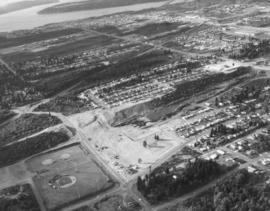
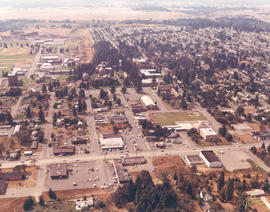
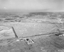
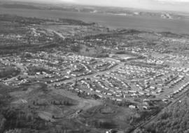
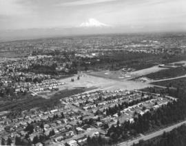
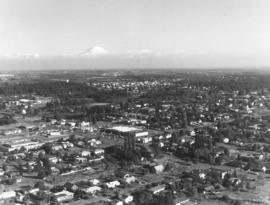
Aerial photograph, looking west, of So. 19th & Mason neighborhood taken on November 8, 1968. Ballpark with lights on the left corner is Heidelberg Field. Land under development across the street from the ballpark is where the Fred Meyer Shopping Center eventually will be built. Glimpse of the Narrows Bridge on far upper portion of photograph. Photograph ordered by Morley Studios.
Aerial views; Neighborhoods--Tacoma--1960-1970; Heidelberg Field (Tacoma);
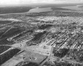
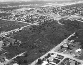
Aerial view of So. 19th & Mason neighborhood looking north toward Point Defiance. Gig Harbor area on upper left. Although the North end was heavily populated, there are still wooded areas remaining in late 1968. Ballpark is Heidelberg Field on So. 19th and Mason. Land directly across the street is being developed for a shopping center eventually featuring Fred Meyer. Street name would change to Stevens once it crosses So. 19th St.; wooded area across Stevens from future shopping center will later become apartments. Photograph ordered by Morley Studios. TPL-3803
Aerial views; Neighborhoods--Tacoma--1960-1970; Heidelberg Field (Tacoma);
1969 Richards stock footage. Aerial view of Tacoma's north end featuring the No. 4th & D St. neighborhood. The Washington State Historical Building is located high above its neighbor, the Stadium Bowl, near the center of the photograph. The French Chateau-styled Stadium High School is on the extreme right edge of photograph.
Aerial views; Neighborhoods--Tacoma--1960-1970; Washington State Historical Building (Tacoma); Stadium Bowl (Tacoma); Stadium High School (Tacoma);
This is the Menlo Park and Sunset Beach area. Gravelly Lake Dr. is believed to be the road running horizontally surrounded by trees and homes. April, 1969, aerial views of the University Place area requested by Puget Sound National Bank. TPL-9241
1969 Richards stock footage. Parkland neighborhood featuring Pacific Lutheran University, Garfield St. and Pacific Avenue as viewed by air in September of 1969. Fall has come to the Pacific Northwest as yards have browned and the trees other than the numerous firs will soon lose their leaves. Looking west from Pacific Ave near the bottom of the photograph is the neighborhood around Pacific Lutheran University. Piggly Wiggly has a supermarket which is at the intersection of Garfield and Pacific; its large letters are clearly visible from the air. To the grocery store's right is believed to be Parkland Lutheran Church & School with its playground behind it. Pacific Lutheran University's upper campus buildings, surrounded by tall firs, are clustered in the center of the picture. Portions of McChord AFB can hazily been seen at the top of the photograph.
Aerial views; Pacific Lutheran University (Parkland)--1960-1970; Neighborhoods--Parkland; Piggly Wiggly (Parkland);
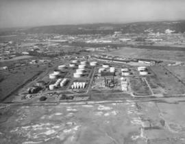
November, 1968, aerial view of U.S. Oil & Refining plant on Tideflats. Petroleum storage tanks dot the landscape, part of the 120-acre plot owned by the U.S. Oil & Refining Co. The plant was built on land just south of Lincoln Ave. Closest waterway would be the Port Industrial Waterway. Photograph ordered by U.S. Oil & Refining.
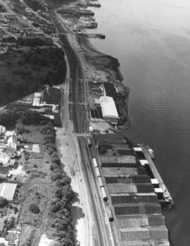
ca. 1969. 1969 Richards stock footage. Burlington Northern line. View looking north of railroad tracks and Bayside Drive next to Commencement Bay. Bayside Drive would change its name to Ruston Way at the Old Town Dock near the top of the photograph. Eventually, Bayside would be absorbed and made wider by becoming Schuster Parkway. Famous restaurant Top of the Ocean near top of photograph; it would be destroyed by fire in April of 1977.
Aerial views; Railroad tracks--Tacoma--1960-1970; Top of the Ocean (Tacoma);
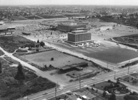
1969 Richards stock footage. View by air of the Tacoma Mall Shopping Center and newly built Tacoma Mall Office Building on July 1, 1969. A new addition to the Tacoma Mall Shopping Center was the 6-story Tacoma Mall Office Building, 4301 So. Pine. Designed by Olympia architects Bennett & Johnson and built by Cascade-Olympic Construction, the 2.7 million dollar structure was one of the first new major office buildings to be built in Tacoma in many years. The building was 90,000 square feet of reinforced concrete and came equipped with soundproof walls and air conditioning. Three high-speed elevators could be utilized to transport quickly customers and staff alike. The large lot provided plenty of free parking. It was conveniently located just off Pine St. and like the rest of the mall, freeway access was close by. The Tacoma Mall Office Building is still in service 36 years after its grand opening in March of 1969. Also shown above are the major stores of the Tacoma Mall: the Bon Marche, Nordstrom Best, and J.C. Penney. (TNT 8-4-68, A-11, TNT 10-27-68, B-11)
Aerial views; Tacoma Mall Office Building (Tacoma); Office buildings--Tacoma--1960-1970; Tacoma Mall Shopping Center (Tacoma); Shopping centers--Tacoma; Bon Marche (Tacoma); Nordstrom Best (Tacoma); J.C. Penney Co. (Tacoma);
ca. 1974. This aerial view of U.S. Oil & Refining Co. land was taken possibly on October 2, 1974. The company owned 120 acres south of Lincoln Avenue in the industrial Tideflats. A glimpse of Mount Rainier can be hazily seen in the background. Photograph ordered by U.S. Oil & Refining Co.
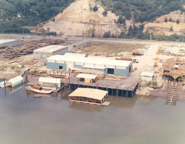
1969 Richards stock footage. Aerial look at newer Western Boat Building plant on Hylebos Waterway. The shipbuilding firm had moved to a seven-acre site on Marine View Dr., vacating the temporary quarters at the Port Industrial Yard it had occupied since fire destroyed their longtime plant on 11th St. One boat is under construction at far right edge of photograph.
Aerial views; Western Boat Building Co. (Tacoma); Boat & ship industry--Tacoma--1960-1970; Boats--Tacoma--1960-1970; Hylebos Waterway (Tacoma);
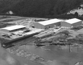
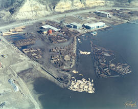
ca. 1969. 1969 Richards stock footage. Unidentified group of buildings on the Hylebos Waterway viewed by air in 1969. Tracks are being built that lead from the water to probably transport logs in log boom. Many cars parked behind buildings.
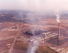
1969 Richards stock footage. Autumn view of Kaiser Aluminum plant in tideflats taken by air in 1969. Located on Taylor Way approximately five miles north of downtown Tacoma, the large Kaiser facility had expanded in late 1968 to manufacture aluminum rods for shipment to California for finishing into electrical conductors. 1969 would see further expansion as its second alumina dome with a 100,000 ton capacity was completed on Pier 7.
Aerial views; Kaiser Aluminum & Chemical Corp. (Tacoma); Aluminum industry--Tacoma--1960-1970;
Northeast Tacoma residential neighborhoods with Commencement Bay in background. These aerial photographs were taken on behalf of Puget Sound National Bank on October 30, 1968. The bank had previously requested aerial views of neighborhoods when expansion of bank branches was anticipated.
1969 Richards stock footage. Closer look at the large wooded area near Sixth Ave., James, No. 11th and No. 9th. Sixth Ave. is near the top half of photograph; Swasey branch library is near intersection of Howard and Sixth. No. 9th is street running nearly horizontal which appears to be swallowed by the woods. 11th St., near the right corner, intersects James which also appears to dead end in the woods.
Aerial view of 40th & Bridgeport area in University Place. University Place's 400,000 gallon water tower is near mid-center; it is located on W. 40th between Bridgeport and Anderson. University Village Shopping Center featuring the Food King supermarket is slightly above and to the right of the water tower. Although University Place was becoming more developed by the late 1960's, there was still an abundance of wooded areas. Photograph requested by Puget Sound National Bank.
Aerial view of Bridgeport Way toward the Sound taken on April 29, 1969. Bridgeport Way is meandering through the woods as it makes a slight curve toward the center of the photograph. 40th St. intersects Bridgeport at upper center with the University Village Shopping Center and water tower visible. Photograph ordered by Puget Sound National Bank.
ca. 1969. 1969 Richards stock footage. Aerial view of the So. 19th & Tyler vicinity with Mount Rainier seen hazily in background. Cheney Stadium is on extreme right center with Heidelberg Field to its left. Henry Foss High School will be built in the wooded area close to both baseball fields.
Aerial views; Rainier, Mount (Wash.); Heidelberg Field (Tacoma); Cheney Stadium (Tacoma);
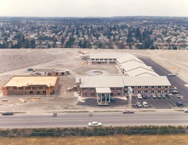
1969 Richards stock footage. Closer aerial view of the Rodeway Inn of America under construction in the summer of 1969. Located near So. 72nd and the freeway, the Rodeway Inn would provide comfortable lodgings for the road-weary traveler. The two-story units were built in a modified U-shape. Constructed on five acres leased from Hillcrest Properties, the 130-unit complex was owned by Northwest Motel Co., Seattle. It would open for business in November of 1969. (TNT 11-2-69, D-14)
Aerial views; Rodeway Inn of America (Tacoma); Motels--Tacoma--1960-1970; Building construction--Tacoma--1960-1970;
1969 Richards stock footage. A new motor inn was being built in the summer of 1969 at 6802 So. Sprague Ave., close to So. 72nd and the freeway. The Rodeway Inn of America was part of a large nationwide chain of motels. Its blue and white logo was a familiar sign to budget conscious travelers who could be assured of comfortable rooms and reasonable prices. Built at a cost of 1.25 million dollars, the 130-unit complex was managed by Johnny H. Lambert. It would offer a restaurant/lounge, heated swimming pool, convention and banquet facilities and meeting rooms. The luxury motel hotel would be open for business in early November, 1969. (TNT 11-2-69, D-14)
Aerial views; Rodeway Inn of America (Tacoma); Motels--Tacoma--1960-1970; Building construction--Tacoma--1960-1970; Signs (Notices);
ca. 1969. 1969 Richards stock footage. This is the Western Boat Building plant on Marine View Dr. taken in 1969. Spread out on seven acres fronting the Hylebos Waterway, the bright blue and white buildings of the shipyard can be clearly seen in this aerial view. Log booms and stacks of logs may belong to Western Boat Building. TPL-6582
Aerial views; Western Boat Building Co. (Tacoma); Boat & ship industry--Tacoma--1960-1970; Logs; Hylebos Waterway (Tacoma);
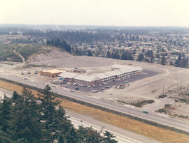
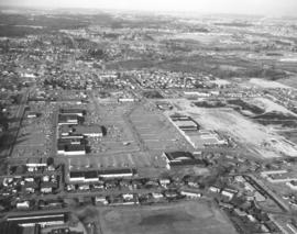
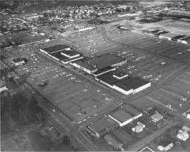
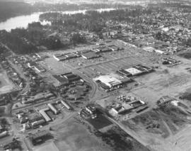
Aerial view, looking north, of the Villa Plaza Shopping Center and various Lakewood neighborhoods on February 26, 1969. The shopping center, with its vast parking lot, is in the center of the photograph. At the bottom left corner is part of Clover Park High School with ball field. A portion of the Lakewood Center can be spotted on the left side of the photograph. Lockburn Junior High, Flett Dairy and Clover Park Voc-Tech are also visible. The Villa Plaza Shopping Center would be renamed the Lakewood Mall in 1989. Photograph ordered by Puget Sound National Bank.
Aerial views; Villa Plaza Shopping Center (Lakewood); Shopping centers--Lakewood--1960-1970; Neighborhoods--Lakewood--1960-1970;
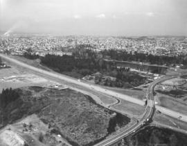
This is how the area around South 72nd Street and I-5 appeared by air in March of 1969. Wapato Lake off of Alaska Street is the large body of water nestled among trees. The cluster of buildings on the far left is the Roadway Inn of America under construction at 6802 So. Sprague. Nearby is a Standard Oil station. This photograph was taken for the Wapato Lake Development Company who had sought permission from the City Planning Commission in early February, 1969, to build a 234-unit lowrise apartment complex on a 12-acre site north of South 72nd between Alaska Street and the freeway. This would entail rezoning and be subject to approval from the city council. We find no record that this complex was built. (TNT 2-4-69, p. 10) TPL-9697
Aerial views; Wapato Lake (Tacoma); Express highways--Tacoma--1960-1970; Rodeway Inn of America (Tacoma);
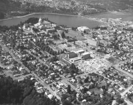
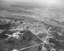
Aerial views of the City of Olympia requested by Puget Sound National Bank. Olympia, the state capital, is located at the head of Budd Inlet in the northern part of Thurston County. It was officially platted in 1850 by settler Edmund Sylvester who laid out a town in the New England style with town square, tree lined streets, Masonic Hall, land for schools and capitol grounds. The grand domed Legislative Building overlooking Capitol Lake was completed in 1927. It was damaged in the April, 1949, earthquake and later in the 1965 earthquake but was repaired and reinforced. The bridge to the right of the capitol buildings was heavily damaged in the earthquake of 2001. (www.ci.olympia.wa.us/information/history)
Aerial views; Legislative Building (Olympia); Streets--Olympia--1960-1970; Capitol Lake (Olympia);
Aerial photograph of the North end neighborhood about No. 4th & "D" in June of 1969. Homes in this area would have exquisite views of Commencement Bay. A large vacant lot on the northwest corner of No. 4th & "D" might be ready for building soon. Home with treed lot in rear of the vacant lot is 401 No. "E;" empty lot is actually 402-08 No. "D;" and home with portico across the street from lot is 401 No. "D." Photograph ordered by award winning architect Robert Billsbrough Price.
Aerial views; Neighborhoods--Tacoma--1960-1970; Houses--Tacoma; Commencement Bay (Wash.);
Mount Rainier peeks over the University Place neighborhood of 27th & Bridgeport Way W. in the fall of 1969. University Place water tower can be seen left-center in the midst of trees in this aerial view. Safeway's large supermarket (center of photograph) is at 7520 - 27th St. W. in a small shopping center. Also located there are Thrifty Drugs and Value Stores. Photograph ordered by Jack Baty & Associates.
Aerial views; Neighborhoods--University Place--1960-1970; Safeway Stores, Inc. (University Place);
Aerial photographs of the City of Olympia in the fall of 1969. View of the Port of Olympia. Olympia, the state capital, had a population then of about 23,000. As the above aerial indicates, there was still plenty of room for growth with acres of uncut timber. Located about 30 miles south of Tacoma, Olympia was named provisional territorial capital in 1853 by Isaac Stevens, Washington's first territorial governor. The name of the city was chosen by local resident Isaac Ebey to commemorate the view of the majestic Olympic Mountains. (www.ci.olympia.wa.us/information/history) Photograph ordered by Puget Sound National Bank.
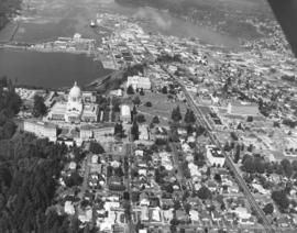
State capitol and grounds. Aerial view looking north on September 5, 1969, of the City of Olympia focusing on the domed Legislative Building and surrounding grounds. Body of water is Capitol Lake. Neatly lined streets are a blend of businesses and large homes. Long road east of the capitol grounds is Capitol Way. Sylvester Park is clump of woods adjacent to Capitol Way. Photograph requested by Puget Sound National Bank.
Aerial views; Streets--Olympia--1960-1970; Legislative Building (Olympia); Capitol Lake (Olympia);
1969 Aerial view of the Villa Plaza Shopping Center. Prior to the construction of the massive Tacoma Mall, there was the Villa Plaza Shopping Center in Lakewood. The Villa Plaza was built in 1957 on the site of the former 200-acre Visitation Villa. By the mid-50's, Lakewood was growing in leaps and bounds and there was a need for more convenient shopping in the suburbs. The Villa Plaza was not the first "one-stop" shopping center in the area--that honor would go to the Lakewood Center--but it had more room for development and most importantly, plenty of free parking. Ads for the Villa Plaza constantly promoted the availability of its 4000 car parking lot. Major downtown stores J.C. Penney, Woolworth and Rhodes would open branches in the Villa Plaza, therefore lessening the necessity of suburban shoppers to venture downtown. Unlike the Tacoma Mall, which would open in 1965, the Villa Plaza was not contained under one roof although many stores were clustered within short walking distances. Photograph ordered by Puget Sound National Bank.
Aerial views; Villa Plaza Shopping Center (Lakewood); Shopping centers--Lakewood--1960-1970;
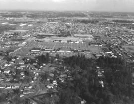
Aerial view of the Villa Plaza Shopping Center and surrounding Lakewood neighborhoods on February 26, 1969. Steilacoom Lake is in the background. St. Francis Cabrini Catholic Church property near left bottom corner. Tenzler Library (now Lakewood Library) close to Gravelly Lake Dr. on extreme left edge. Photograph ordered by Puget Sound National Bank.
Aerial views; Villa Plaza Shopping Center (Lakewood); Shopping centers--Lakewood--1960-1970; Lake Steilacoom (Wash.); Neighborhoods--Lakewood--1960-1970;
View by plane of Villa Plaza Shopping Center and surrounding Lakewood neighborhoods on February 26, 1969. The Villa Plaza's 4000-car parking lot and congregation of large stores were major attractions. In 1969, the shopping center was twelve years old and facing competition from the younger Tacoma Mall Shopping Center. There was still room for expansion for the Lakewood facility but it lacked direct freeway access that the Tacoma Mall enjoyed. Photograph ordered by Puget Sound National Bank.
Aerial views; Villa Plaza Shopping Center (Lakewood); Shopping centers--Lakewood--1960-1970; Neighborhoods--Lakewood--1960-1970;