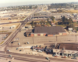
These buildings at the intersection of 112th & Meridian appears to be under construction in April of 1973. This may be the location of the new "Willows" 10-acre shopping center which would open in May. Piggly-Wiggly supermarket and 15 other stores including a Hallmark, State Farm Insurance, and Sunrise Brokers would be the first stores to open; Pay N Save, Puget Sound National Bank, and others would follow in August or September. Aerial photograph ordered by Collison Realty. (TNT 3-18-73, D-10-article on shopping center)
Aerial views; Neighborhoods--Puyallup--1970-1980; Building construction--Puyallup--1970-1980;
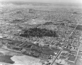
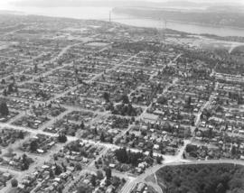
This is what the populous south side of Tacoma looked like in April of 1973. The aerial photograph of the South 72nd and South Lawrence Sts. looking north was taken on behalf of Puget Sound National Bank. The Tacoma Mall Shopping Center is at the extreme top -right side- of the photograph.
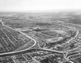
One of a series of aerial views, taken aboard a helicopter on April 2, 1973, of the Tacoma Mall area as requested by Puget Sound National Bank. This view is east from South 56th & Manitou area. The Tacoma Mall is upper center with I-5 running next to the shopping center. Heavily wooded area in direct center is part of South Park and also the Tacoma Cemetery, established in 1875. Northern Pacific Shops are lower center.
Aerial views; Neighborhoods--Tacoma--1970-1980; Tacoma Mall Shopping Center (Tacoma);
Aerial view on April 2, 1973, of the Nalley Valley and 38th St. interchange. Atlas Foundry is on the right side. The Tacoma Mall is left-center, adjacent to the freeway. There were a variety of ways to get to the Mall, including the heavily utilized South Pine and South 38th St. entrances. Less than nine years old and already boasting of several large department stores as well as specialty shops, the Mall was able to draw a shopping population from as far south as Olympia and from as far north as Seattle. Photograph ordered by Puget Sound National Bank.
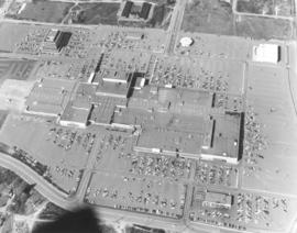
Another in a series of aerial photographs taken on April 2, 1973, for Puget Sound National Bank regarding the Tacoma Mall and surrounding areas. The hundreds of automobiles in the parking lot appear the size of matchbox cars when viewed via helicopter on this sunny spring day. Parking was obviously no problem and the weather would not be a factor either, since the Tacoma Mall was an enclosed, climate-controlled shopping center. J.C. Penney, the Bon Marche, Nordstrom and the soon-to-be constructed Rhodes department store on the west side would be the four major stores anchoring the Mall. Separate buildings in the Mall area included (l-r)the Tacoma Mall Office Building, the Bon Marche Tire Center, the round Pacific National Bank of Washington and the Tacoma Mall Theatre.
Aerial views; Parking lots--Tacoma--1970-1980; Tacoma Mall Shopping Center (Tacoma); Shopping centers--Tacoma--1970-1980; Tacoma Mall Office Building (Tacoma); Tacoma Mall Theater (Tacoma); Pacific National Bank of Washington (Tacoma);
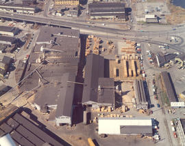
ca. 1973. 1973 Richards stock footage. Aerial photograph, probably taken in the fall of 1973, of the St. Regis Paper Co. The plant, the county's largest non-military employer, was located between the Puyallup and St. Paul Waterways. St. Regis would be acquired by Champion International Corp. in 1984 and subsequently sold to Simpson Tacoma Kraft the following year. Simpson Tacoma Kraft still maintains the plant in 2007.
Aerial views; St. Regis Paper Co. (Tacoma)--1970-1980; Puyallup Waterway (Tacoma); St. Paul Waterway (Tacoma);
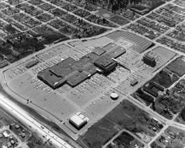
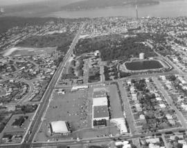
Closer look at the Tacoma Mall Shopping Center as seen by air on April 2, 1973. 25 more stores would open on July 25th bringing the total number of stores found within the Mall to 110. Construction would begin soon on the two-story Rhodes Bros. department store at the far west end. Prominent buildings easily noted in this photograph are the Bon Marche, which was the first occupant of the Mall; the luxurious Tacoma Mall Theatre (bottom center); Pacific National Bank of Washington's circular building; the Bon Marche Tire Center, directly across from the Bon and the six-story Tacoma Mall Office Building. What the Tacoma Mall enjoyed, and downtown shopping lacked, was an abundance of free parking and a climate controlled atmosphere. Access to the Mall was easy with several entrances and quick freeway travel time. The wooded area across the Mall on South 48th St. would eventually become Best Buy, a Pierce County Transit Center, and closer to Pine St., the Social Security office. Ordered by Puget Sound National Bank.
Aerial views; Tacoma Mall Shopping Center (Tacoma); Shopping centers--Tacoma--1970-1980; Parking lots--Tacoma--1970-1980; Bon Marche (Tacoma); Tacoma Mall Theater (Tacoma); Pacific National Bank of Washington (Tacoma); Tacoma Mall Office Building (Tacoma)
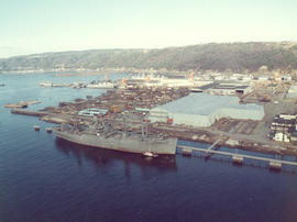
ca. 1973. 1973 Richards stock footage. Unidentified ships docked at Port of Tacoma, as seen by air, in 1973. The Port, then as now, was a busy, bustling place which saw the arrival and departure of many ships during the year.
1973 Richards stock footage. Color aerial view of the Export Pacific plant, 1942 E. 11th St., as photographed on September 10, 1973. The firm was headed by Chauncey L. Griggs and was involved in the lumber export business.
1974 Richards stock footage. Construction of the new Liberty House/Rhodes department store at the Tacoma Mall is proceeding rapidly during the spring of 1974. The two-story building is being built at the Mall's far west end for an estimated $2,000,000. There would be 128,093 square feet of floor space. The store was scheduled to open in the fall of 1974. Also included in this May, 1974, aerial view of the shopping center: the Tacoma Mall Office Building (in rear), the 10-month old west end addition to the Mall, Nordstrom, and the Bon Marche. (TNT 1-13-74, F-8 article)
Aerial views; Aerial photographs; Tacoma Mall Shopping Center (Tacoma); Shopping centers--Tacoma--1970-1980; Building construction--Tacoma--1970-1980; Tacoma Mall Office Building (Tacoma); Bon Marche (Tacoma); Liberty House (Tacoma);
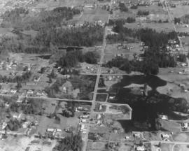
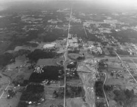
Aerial photographs of the area between 320th in Federal Way, North Puyallup, Pacific Highway South and Valley Ave. were taken on a clear day in late March, 1975. This particular view was not positively identified. Lot sizes appeared large and the area not densely occupied. There are two lakes/ponds visible. Photograph ordered by Puget Sound National Bank.
Puget Sound National Bank had requested aerial photographs of the land between 320th in Federal Way, North Puyallup, Pacific Highway South and Valley Ave. in late March of 1975. The area shown above is heavily wooded with small neighborhoods scattered among the trees.
Closer look by air at Pearl St. in Tacoma's west end. Pearl St. is the street farthest left running vertically toward Point Defiance. Parallel to Pearl is Orchard St. with the playing fields of Wilson High School nearby. North 11th St. runs horizontally intersecting Orchard and Pearl. The Auto View Drive-In is to the left of Pearl. ASARCO's famous smokestack is clearly visible near the top of the photograph. Photograph ordered by Puget Sound National Bank.
Aerial views; Neighborhoods--Tacoma--1970-1980; Auto View Drive-In (Tacoma); Smokestacks--Tacoma;
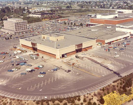
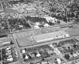
This section of Sixth Avenue looks a bit different now than it did in 1974. Kmart, with its 1000-car parking lot, is still there but the area directly across the street has been dotted with small shopping malls. In 1974 the only business immediately across Kmart was a new Goodyear store which would celebrate its grand opening at the tail end of October, 1974. The First Christian Church is set on a large wooded lot close to Goodyear. Wilson High School, 12th & Orchard, is the cluster of buildings near the top left center. Aerial photograph ordered by Puget Sound National Bank.
Aerial views; Neighborhoods--Tacoma--1970-1980; Kmart (Tacoma); Parking lots--Tacoma--1970-1980; Goodyear Service (Tacoma); First Christian Church (Tacoma); Woodrow Wilson High School (Tacoma);
Aerial view of the Westgate neighborhood, taken via helicopter on August 28, 1974, on behalf of Puget Sound National Bank. Shopping center below is the Westgate Shopping Center at North 26th & Pearl St. The Westgate Thriftco (formerly known as Thriftway) was one of the main tenants. North 26th runs horizontally at bottom of the photograph; it intersects with Pearl Street on the left. Pearl is the extremely long street that will eventually end at Point Defiance Park. Other landmarks clearly visible include the North 30th St. reservoir and water tower at photo's right-center and ASARCO's smokestack at top.
Aerial views; Neighborhoods--Tacoma--1970-1980; Westgate Shopping Center (Tacoma); Reservoirs--Tacoma; Water towers--Tacoma; Thriftco (Tacoma); Smokestacks--Tacoma;
Westgate Shopping Center and environs via helicopter on August 28, 1974. The Westgate Shopping Center at North 26th & Pearl would later expand to include the large block across North 26th St. Most of the lot was undeveloped at the time of this 1974 photograph. Major streets on display are Pearl and Orchard St. (running vertically and parallel to one another) intersected by North 21st and North 26th. The North 30th St. water tower and reservoir is located at the upper right corner. Photograph ordered by Puget Sound National Bank.
Aerial views; Neighborhoods--Tacoma--1970-1980; Westgate Shopping Center (Tacoma); Water towers--Tacoma; Reservoirs--Tacoma;
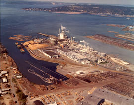
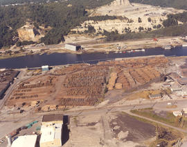
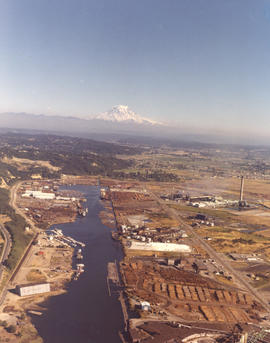
Log storage along the Hylebos Waterway. Pan Pacific Trading were log exporters with locations at 3502 Lincoln Ave and Yard 2 at 2407 Port of Tacoma Rd. This August, 1974, aerial shows the large Pan Pacific lot filled with stacks of logs. Color photograph ordered by Pan Pacific Trading Co.
Mount Rainier casts a benevolent eye on the industrial Tideflats in this color photograph taken on August 9, 1974. Kaiser Aluminum plant with 500-foot stack is on the right and Hylebos Waterway on the left. Piles of logs near bottom belong to Pan Pacific Trading Co., log exporters. Color photograph ordered by Pan Pacific Trading Co.
Aerial views; Pan Pacific Trading Co. (Tacoma); Logs; Lumber industry--Tacoma--1970-1980; Shipping--Tacoma--1970-1980; Kaiser Aluminum & Chemical Corp. (Tacoma); Rainier, Mount (Wash.); Hylebos Waterway (Tacoma);
This is the Skyline district as seen by air in June of 1971. This area is close to the Narrows Bridge. Jackson Avenue is the street running horizontally. Above Jackson and making a gentle curve is Narrows; it will eventually become 26th St. To the extreme right running vertically is 17th which will become Westgate. Photograph ordered by Puget Sound National Bank.
Aerial photographs of the Skyline District taken on behalf of Puget Sound National Bank in June of 1971. Notable features included view of the Narrows, Cushman Towers, Gig Harbor (upper left corner) and Point Defiance Park (segment extending into the Narrows). The open land near bottom of photograph (not acreage with trails) has probably been developed since 1971.
Aerial views; Neighborhoods--Tacoma--1970-1980; Electric lines--Tacoma--1970-1980; Towers;
Aerial view of Pearl & Vassault Sts. in the north end in the summer of 1971. The ASARCO smelter can be seen at the top of the photograph. Pearl and Vassault Sts. run parallel horizontally near center. At 5102 North Pearl is a tall building which was the Image, a youth center, in 1971. It is now the Antique Sandwich Co. Photograph ordered by Puget Sound National Bank.
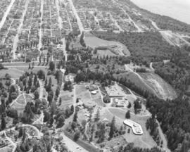
Aerial view, taken in June of 1971, of Point Defiance Park and environs. In the photograph's upper center is the Franke Tobey Jones Home and grounds. The English Tudor-styled retirement home opened in 1925 and was named after the wife of a founder of St. Paul & Tacoma Lumber Co. Mrs. Jones had donated four acres of land close to Point Defiance Park so that retirees could live with dignity in beautiful settings. The Franke Tobey Jones home is just a short distance through the trees to Point Defiance. A small portion of the 700-acre park is visible with the round Aquarium and exhibits. Photograph ordered by Puget Sound National Bank.
Aerial views; Point Defiance Park (Tacoma); Franke Tobey Jones Home (Tacoma);
North end view about North 30th St. as seen by air on June 2, 1971. Narrows Bridge near top of photograph; Cushman Towers nearby. North End water tower and reservoir at upper center. North 30th is the street that winds gently next to the reservoir. Stevens St. is horizontal line, light colored, near bottom of photograph. Mason Gulch is wooded area at right corner. Photograph ordered by Puget Sound National Bank.
Aerial views; Tacoma Narrows Bridge (Tacoma); Electric lines--Tacoma; Water towers--Tacoma; Reservoirs--Tacoma; Mason Gulch (Tacoma);
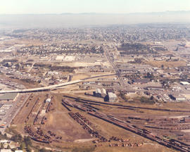
Aerial view encompassing So. 38th St., Union Ave., and South Tacoma Way on September 20, 1971. Northern Pacific shops at lower center. Reddish building with dark roof in mid-center is the Tacoma Sports Arena (formerly known as Tacoma Ice Palace). Ben's Truck Parts had taken possession of the building, purchased for $175,000, on September 20th, the date of this photo shoot. Also shown above is the new $3,000,000 Union Ave. bridge and intersection (mid-left center), part of the urban arterial street construction and 90% paid for by the State of Washington; it replaced the old 34-year-old viaduct. Large white building in big parking lot is the White Front store; Tacoma Mall Shopping Center is at far right edge. Color photograph ordered by Ben's Truck Parts. (TNT 9-3-71, p. 1 - article)
Aerial view of former Tacoma Sports Arena, recently sold to Ben's Truck Parts. It is the large building in the center of photograph with dark brown roof and reddish walls. Built in 1946, it opened as the Tacoma Ice Palace and had a 14,400 sq.ft. skating area, room enough for 500 skating couples. The Ice Palace was 279 feet long and had spans on the roof of 162-feet, second largest in the Northwest at the time. It had been the home of the (defunct) Tacoma Rockets pro hockey team, ice skating, motorcycle racing and live boxing. More recently, Roller Derby, pro wrestling, dances and flower shows had been held there. Ben's Truck Parts bought the building for $175,000 and would take possession on September 20, 1971. Color view of Tacoma Sports Arena: South Tacoma Way is street running horizontally at bottom of photograph; 38th St. is long street running vertically near left; Post Office Terminal Annex is at 38th & Warner, just above the Arena. Warner turns into Union Ave. after the intersection with 38th St. Photograph ordered by Ben's Truck Parts. (TNT 9-3-71, p. 1- article)
View from air of the Tacoma Sports Arena (formerly known as the Tacoma Ice Palace), 3801 South Union Avenue. Ben's Truck Parts had taken possession of the 25-year-old building on September 20, 1971. Originally built as an ice skating facility for $305,000, it was the home of the Pacific Coast League Tacoma Rockets hockey team for several years. Later usage of the Arena expanded to include live boxing events, motorcycle racing, Roller Derby, pro wrestling and dances. It was sold to Ben's Truck Parts for $175,000. Other structures of note in the above photograph include the Post Office's Terminal Annex on Warner St. and the Tacoma Mall Shopping Center at upper left corner. Color photograph ordered by Ben's Truck Parts. (TNT 9-3-71, p. 1 - article)
Aerial views; Tacoma Sports Arena (Tacoma); Tacoma Ice Palace (Tacoma); Ben's Truck Parts (Tacoma); Tacoma Mall Shopping Center (Tacoma);
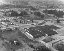
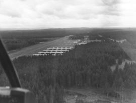
This is possibly Thun Field, just south of the City of Puyallup in the South Hill neighborhood. The air field appears to be hemmed in by tall firs. Photograph taken on January 2, 1972; ordered by Puget Sound National Bank.
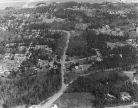
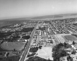
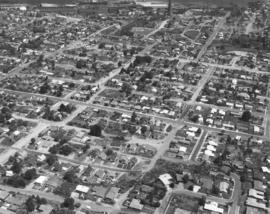
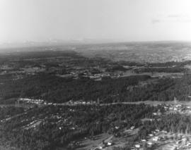
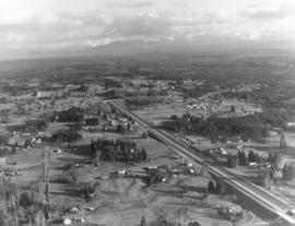
One of a series of photographs taken by air on January 2, 1972, of the Puyallup-area neighborhoods of 112th & Meridian and vicinity. Tall evergreens blanket the area with a few homes carved out of the forests. Photograph ordered by Puget Sound National Bank.
Another in a series of photographs taken by air on January 2, 1972, of the Meridian South & 112th St. neighborhoods. The landscape would change in the following years as the area started to expand. Photograph ordered by Puget Sound National Bank.