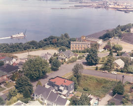
Showing 824 results

Collections
Aerial Photography With digital objects
Print preview View:

D147400-10

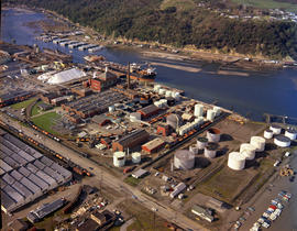
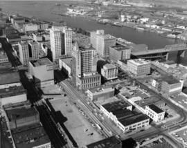
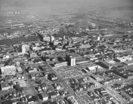
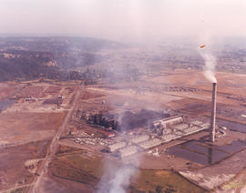
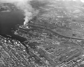
This aerial view of Tacoma's business district and industrial tideflats was taken on April 5, 1966 - forty years ago. From high above the city some familiar landmarks, such as the 11th Street Bridge (now the Murray Morgan Bridge) and the channelized Puyallup River, are easy to pick out. Heavy smoke billows from the St. Regis Paper Company plant (now Simpson Tacoma Kraft) which is flanked by the Puyallup Waterway and the St. Paul Waterway. Missing are the new 509 cable-stay bridge spanning the Thea Foss Waterway and I-705.


Aerial photographs; City Waterway (Tacoma); 11th Street Bridge (Tacoma); St. Regis Paper Co. (Tacoma)--1960-1970;

D149224-6

Aerial photographs of the So. 19th & Union Ave. looking west toward So. 19th and surrounding north end neighborhoods. The 46-unit apartment complex, Boyd Lundstrom's Unionaire, is H-shaped building with dark roof. It is across the street from the year-old Allenmore Medical Center complex, 1901 So. Union Ave. The medical-dental building with a 50-bed hospital opened in the summer of 1965. The fully airconditioned edifice was built at a cost of approximately $1,300,000. It was conveniently located with direct access to the freeway and Narrows Bridge route. Photograph ordered by Puget Sound National Bank who would later build a branch at 3501 So. 19th, across the street from Allenmore .


Aerial photographs; Allenmore Medical Center (Tacoma); Unionaire Apartments (Tacoma); Neighborhoods--Tacoma--1960-1970;

D149017-1

This aerial view of the Northern Pacific Railroad tracks which run along the edge of Commencement Bay just south of Old Tacoma, and adjoining northend neighborhoods, dates from August 1966; before the Schuster Parkway was built. The Sperry Flour grain elevators, located at what is now 3 Schuster Parkway, were located next to the tracks. The General Mills, Sperry Division, had closed in 1965. The plant's grain towers were torn down in 1973 and its deteriorating dock, the last portion of the mill, was demolished in 1989. Work on Schuster Parkway began in 1973 and was completed in 1976. Photograph ordered by Swanson-McGoldrick, Inc.


Aerial photographs; General Mills, Inc., Sperry Division (Tacoma); Piers & wharves--Tacoma--1960-1970; Railroad tracks--Tacoma--1960-1970; Neighborhoods--Tacoma--1960-1970; Waterfronts--Tacoma--1960-1970;

D149142-3

Another aerial view ordered by Bank of Tacoma of the Veterans Drive S.W. neighborhood in Lake City. Taken on August 7, 1966, a glimpse of American Lake can be spotted in the left upper corner. The county park is located in the vicinity of the lake. Veterans Drive is the curving roadway in the center of the photograph. Military Road is believed to be street on right side of photograph.


Aerial photographs; Neighborhoods--Lake City; American Lake (Wash.);

D149142-5

Closer view of the Lake City neighborhood including Veterans Dr. S.W. on August 7, 1966. American Lake in upper left corner. Washington is the street on extreme right. Photograph ordered by Bank of Tacoma.


Aerial photographs; Neighborhoods--Lake City; American Lake (Wash.);

D150900-406C

1967 Richards Studio stock file. May 2, 1967, aerial view in color of sprawling Hooker Chemical plant, 605 Alexander Ave., in the Tacoma tideflats. A ship is docked on the Hylebos Waterway next to the facility, ready to load and unload Hooker products. Easy access to water, rail and roadways was a factor in locating the large plant in Tacoma in 1928. Hooker was one of the primary suppliers to Pacific Northwest pulp and paper companies of chemicals used to bleach and refine wood pulp. Later it would also manufacture soap and refine petroleum products.


Aerial photographs; Hooker Electrochemical Co. (Tacoma); Chemical industry--Tacoma--1960-1970; Industrial facilities--Tacoma--1960-1970; Hylebos Waterway (Tacoma);

D150900-355

1967 Richards stock file. The area around University Place's 40th & Bridgeport neighborhoods was set for further expansion in October, 1967, with the opening of the new University Village Shopping Center. This view by air on October 28, 1967, shows the shopping center with large parking lot carved out of the surrounding trees. Food King and Don's Village Drugs would be among the occupants of the shopping center which had been designed by architects Lyle Swedberg & Associates.


Aerial photographs; Neighborhoods--University Place; Shopping centers--University Place; Food King (University Place);

D151531-6

Overall aerial view of the Port of Tacoma's new Kaiser Dome and crane located at Pier 7 on April 28, 1967. Puyallup River is in background. Log dumps and cargo ships in waterway. Alumina from Australia, substance used in the production of aluminum, will be unloaded from huge cargo ships similar to the above, drawn into the 150-foot high crane, and dumped into a hopper before being transferred by conveyor to the dome-shaped storage and load-out facility. The Port will handle alumina under contract with Kaiser Aluminum. (TNT 11-13-66, D-19, TNT 2-15-67, A-1)


Aerial photographs; Kaiser Aluminum & Chemical Corp. (Tacoma); Storage tanks--Tacoma; Hoisting machinery; Piers & wharves--Tacoma--1960-1970; Cargo ships--Tacoma--1960-1970; Logs; Puyallup River (Wash.);

D151531-8

Aerial view on April 28, 1967, of the new Kaiser dome and 150-foot crane at the Port of Tacoma's Pier 7. The dome will be able to store some 50,000 tons of alumina from Australia under contract with Kaiser Aluminum. The $880,000 crane appears to dwarf the dome at 205 feet with boom raised. It has a 40-ton capacity 100 feet from the dock and is capable of reaching completely over a conventional ship. (TNT 11-13-66, D-19, TNT 2-15-67, A-1)


Aerial photographs; Kaiser Aluminum & Chemical Corp. (Tacoma); Storage tanks--Tacoma; Hoisting machinery; Piers & wharves--Tacoma--1960-1970; Logs;

D151503-1

April, 1967, aerial photograph of Portland Avenue neighborhood near E. 83rd and 84th Streets taken on behalf of Puget Sound National Bank. There was still a lot of vacant land in the area. Banks would often request aerials of various Tacoma neighborhoods when deciding on future locations for branches. Puget Sound National Bank would later build a branch near E. 72nd and Portland Ave.


Aerial photographs; Neighborhoods--Tacoma--1960-1970;

D152770-1C

Color aerial of Tacoma Tideflats, featuring Reichhold Chemicals at 2340 Taylor Way. Reichhold's taupe-colored buildings blend in with the acres of dirt in this November, 1967, photograph. Reichhold manufactured chemicals for various Pacific Northwest industries including the stalwart plywood field. The company had initially established its plant on 51 acres on nearby Lincoln Ave in 1956 but had moved to the Taylor Way location by 1963. Hylebos Waterway is toward top of photograph along with PennSalt facilities. Photograph ordered by Reichhold Chemicals, Inc.


Aerial photographs; Reichhold Chemicals, Inc. (Tacoma); Hylebos Waterway (Tacoma);

D154000-272

Aerial view of downtown Tacoma taken on September 4, 1968. The 11th St. Bridge spans the City (Thea Foss) Waterway to connect the business district to the more industrial Tideflats. Many of Tacoma's landmark buildings are in sight including the spire of the Puget Sound National Bank Bldg., the Tacoma Building, the Washington Building, the Rust Building and Peoples department store. The large vacant space on Pacific Ave. was slated for the Park Plaza South parking garage.


Aerial views; Aerial photographs; Business districts--Tacoma--1960-1970; Puget Sound National Bank (Tacoma); 11th Street Bridge (Tacoma); Tacoma Building (Tacoma); Washington Building (Tacoma); Rust Building (Tacoma); City Waterway (Tacoma);

D154000-275

1968 Richards stock aerial footage. Closer look at primary businesses and institutions in Tacoma's commercial downtown area. Centered is the expansive County-City Building which replaced Old City Hall in 1959. On the left side is Central School's Gothic styled eight-storied building. On the right side of the County-City Building is the Tacoma Public Library. The Washington State Armory is behind the parking lot of the County-City Building. Across 11th Street from the Armory is the Tacoma Vocational-Technical School (to be renamed L.H. Bates Vocational-Technical in 1969). The Hilltop neighborhood is closer to the bottom of the photograph. 11th Street Bridge at the top of the photograph leads into the Tacoma industrial Tideflats as it provides access over the City (now Thea Foss) Waterway. Primary office buildings and banks visible near the water are the Perkins Tacoma, and Washington buildings and Puget Sound National Bank.


Aerial views; Commercial streets--Tacoma--1960-1970; County-City Building (Tacoma); Central School (Tacoma); Tacoma Public Library (Tacoma); State Armory (Tacoma); Perkins Building (Tacoma); Tacoma Building (Tacoma); City Waterway (Tacoma);

D155022-A

Aerial views of Northeast Tacoma/Federal Way neighborhoods requested by Puget Sound National Bank. The area was still heavily wooded in October of 1968. Puget Sound National Bank may have been photographing Northeast Tacoma and adjoining Federal Way in anticipation of opening a new branch in the area. In mid-center of the photograph is a small shopping center that held the National Auto Parts store, Walkley's Pharmacy, and Mosier's Enco Service Station. It was located on 21st Ave. S.W. in Federal Way. 21st Ave. S.W. turns in one direction into 29th St. N.E. which is in Tacoma; when it turns the other way it develops into S.W. 356th St. in Federal Way.


Aerial views; Aerial photographs; Neighborhoods--Tacoma--1960-1970; Neighborhoods--Federal Way--1960-1970; National Auto Parts (Federal Way); Mosier's Enco Service Station (Federal Way);

D155600-72C

1969 Richards stock footage. Aerial view of the Aladdin Apartments, 2112 So. 90th St., which were completed in 1968. Built by local developer Oscar Hokold, the units were all electric and rented for $135 and up. The Aladdin was centrally located, close to the freeway and mere minutes from the Tacoma Mall.


Aerial views; Aladdin Apartments (Tacoma); Housing developments--Tacoma--1960-1970;

D155600-360C

1969 Richards stock footage. Aerial view of No. 4th & D neighborhood during the summer of 1969. The Washington State Historical Society building on Stadium Way is the neo-classical structure next to Stadium Bowl. Many homes with Commencement Bay views were built in this neighborhood. A boat is seen streaming toward shore; this is believed to be the snagboat, the W.T. Preston, which was the last working sternwheeler on Puget Sound.


Aerial views; Boats--Tacoma--1960-1970; Neighborhoods--Tacoma--1960-1970; Washington State Historical Building (Tacoma); Stadium Bowl (Tacoma);

D155600-160C

ca. 1969. 1969 Richards stock footage. Unidentified group of buildings on the Hylebos Waterway viewed by air in 1969. Tracks are being built that lead from the water to probably transport logs in log boom. Many cars parked behind buildings.


Aerial views; Hylebos Waterway (Tacoma); Industrial facilities--Tacoma--1960-1970; Logs;

D155600-211C

1969 Richards stock footage. Autumn view of Kaiser Aluminum plant in tideflats taken by air in 1969. Located on Taylor Way approximately five miles north of downtown Tacoma, the large Kaiser facility had expanded in late 1968 to manufacture aluminum rods for shipment to California for finishing into electrical conductors. 1969 would see further expansion as its second alumina dome with a 100,000 ton capacity was completed on Pier 7.


Aerial views; Kaiser Aluminum & Chemical Corp. (Tacoma); Aluminum industry--Tacoma--1960-1970;

D155022-1

Northeast Tacoma residential neighborhoods with Commencement Bay in background. These aerial photographs were taken on behalf of Puget Sound National Bank on October 30, 1968. The bank had previously requested aerial views of neighborhoods when expansion of bank branches was anticipated.


Aerial views; Neighborhoods--Tacoma--1960-1970;

D155600-145

1969 Richards stock footage. Closer look at the large wooded area near Sixth Ave., James, No. 11th and No. 9th. Sixth Ave. is near the top half of photograph; Swasey branch library is near intersection of Howard and Sixth. No. 9th is street running nearly horizontal which appears to be swallowed by the woods. 11th St., near the right corner, intersects James which also appears to dead end in the woods.


Aerial views; Neighborhoods--Tacoma--1960-1970;

D155750-1

Aerial view of 40th & Bridgeport area in University Place. University Place's 400,000 gallon water tower is near mid-center; it is located on W. 40th between Bridgeport and Anderson. University Village Shopping Center featuring the Food King supermarket is slightly above and to the right of the water tower. Although University Place was becoming more developed by the late 1960's, there was still an abundance of wooded areas. Photograph requested by Puget Sound National Bank.


Aerial views; Neighborhoods--University Place;

D155750-8

Aerial view of Bridgeport Way toward the Sound taken on April 29, 1969. Bridgeport Way is meandering through the woods as it makes a slight curve toward the center of the photograph. 40th St. intersects Bridgeport at upper center with the University Village Shopping Center and water tower visible. Photograph ordered by Puget Sound National Bank.


Aerial views; Neighborhoods--University Place;

D155600-54

ca. 1969. 1969 Richards stock footage. Aerial view of the So. 19th & Tyler vicinity with Mount Rainier seen hazily in background. Cheney Stadium is on extreme right center with Heidelberg Field to its left. Henry Foss High School will be built in the wooded area close to both baseball fields.


Aerial views; Rainier, Mount (Wash.); Heidelberg Field (Tacoma); Cheney Stadium (Tacoma);

D155600-349C

1969 Richards stock footage. Closer aerial view of the Rodeway Inn of America under construction in the summer of 1969. Located near So. 72nd and the freeway, the Rodeway Inn would provide comfortable lodgings for the road-weary traveler. The two-story units were built in a modified U-shape. Constructed on five acres leased from Hillcrest Properties, the 130-unit complex was owned by Northwest Motel Co., Seattle. It would open for business in November of 1969. (TNT 11-2-69, D-14)


Aerial views; Rodeway Inn of America (Tacoma); Motels--Tacoma--1960-1970; Building construction--Tacoma--1960-1970;

D155600-351C

1969 Richards stock footage. A new motor inn was being built in the summer of 1969 at 6802 So. Sprague Ave., close to So. 72nd and the freeway. The Rodeway Inn of America was part of a large nationwide chain of motels. Its blue and white logo was a familiar sign to budget conscious travelers who could be assured of comfortable rooms and reasonable prices. Built at a cost of 1.25 million dollars, the 130-unit complex was managed by Johnny H. Lambert. It would offer a restaurant/lounge, heated swimming pool, convention and banquet facilities and meeting rooms. The luxury motel hotel would be open for business in early November, 1969. (TNT 11-2-69, D-14)


Aerial views; Rodeway Inn of America (Tacoma); Motels--Tacoma--1960-1970; Building construction--Tacoma--1960-1970; Signs (Notices);

D155600-441C

ca. 1969. 1969 Richards stock footage. This is the Western Boat Building plant on Marine View Dr. taken in 1969. Spread out on seven acres fronting the Hylebos Waterway, the bright blue and white buildings of the shipyard can be clearly seen in this aerial view. Log booms and stacks of logs may belong to Western Boat Building. TPL-6582


Aerial views; Western Boat Building Co. (Tacoma); Boat & ship industry--Tacoma--1960-1970; Logs; Hylebos Waterway (Tacoma);

D156779-18

Aerials of Brookdale area around Brookdale Golf Course, Chesney Rd. E., Givens Rd. E., and Waller Rd. E. taken on August 18, 1969. The Brookdale Golf Course was built in 1931 and offered its patrons fine views of Mount Rainier while striding the par-71, 6400-yard course. Photograph ordered by Healy Bros.


Aerial views; Aerial photographs; Brookdale Golf Club (Parkland);

D156922-8

Closer September, 1969, northwest to southeast aerial view of intersection of 27th W. and Bridgeport in University Place. (see D156922, image 7 for extended view) This now busy intersection was still fairly undeveloped in 1969; there are a few businesses including the Park & Shop market at 26th & Bridgeport (parking lot visible at bottom) and several service stations--Paul's Chevron, University Place Shell around 27th & Bridgeport. University Place water tower can barely be seen in upper center of photograph amidst the towering trees. The cap of Mount Rainier forms a beautiful background. Photograph ordered by Jack Baty & Associates.


Aerial views; Neighborhoods--University Place--1960-1970; Automobile service stations--University Place;

A71928-1

Aerial views of Rainier State School in Buckley were taken in late December, 1952, at a height of 800-1000 feet. Rainier School had experienced severe overcrowding in the late 1940's and was forced to request nearly $6,500,000 in aid from state and federal sources to alleviate the housing crunch. Rainier School was only one of two specialized state schools in Washington State and had long waiting lists. It boarded physically and mentally handicapped children, and by the early 1950's, had an enrollment of nearly 2000.


Aerial photographs; Western State Custodial School (Buckley); Institutional care--Buckley; Children--Health & welfare

A71928-3

Mount Rainier looms over the sprawling campus of the Rainier State School in Buckley in December of1952. This aerial photograph, taken at a height of 800-1000 feet, shows the large institution and the rural landscape that surrounded it. The Rainier School, which housed mentally and physically handicapped children, experienced severe overcrowding during the late 1940's to early 1950's.


Aerial photographs; Western State Custodial School (Buckley); Institutional care--Buckley; Children--Health & welfare; Rainier, Mount (Wash.);

Results 181 to 210 of 824