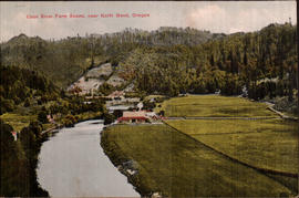
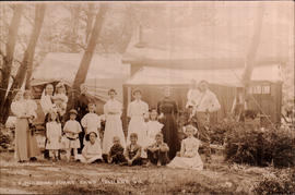
The Coos River is approximately 60 miles long, in southwest Oregon. It rises in western Douglas County, in the mountains west of Roseburg. It flows generally west through the mountains, entering the eastern end of Coos Bay on the Pacific, near the town of Coos Bay. It rises in western Douglas County, in the mountains west of Roseburg. It flows generally west through the mountains, entering the eastern end of Coos Bay on the Pacific, near the town of Coos Bay. circa 1911.
Printed on front: Coos River Farm Scene, near North Bend, Oregon
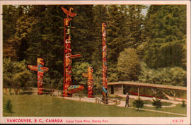
The totem pole display area at Brockton Point in Stanley Park is the most visited tourist attraction in all of British Columbia. Several of the original poles had been carved as early as the late 1880s but time plus the elements took their toll over the ensuing decades. The Skedans Mortuary Pole was replaced in 1962 by a replica with all remaining totems being sent to various museums for future preservation and new ones commissioned or loaned to the Park Board between 1986 and 1992. circa 1950.
Printed on front: Vancouver, B.C., Canada Indian Totem Poles, Stanley Park
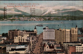
Burrard Inlet lies between the city of Vancouver and the north shore municipalities of West Vancouver and North Vancouver in British Columbia, Canada. circa 1917.
Printed on front: View looking across Burrard Inlet, showing Business Section. Vancouver, B. C.
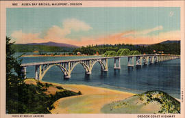
The Alsea Bay Bridge, connecting Waldport with the northern part of Lincoln County on US 101, was originally built using sand taken from the bay. This sand has a high salt content and over the years, the bridge became unsafe. It was demolished, and a new bridge at the same site opened in 1991. circa 1936.
Printed on front: Alsea Bay Bridge, Waldport, Oregon Oregon Coast Highway
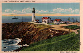
The 93 foot tower of the Yaquina Lighthouse is located on a narrow point of land jutting due west into the Pacific Ocean north of Newport, at Yaquina Head Outstanding Natural Area. Built in 1872, it has been lit since 1873--although the original wicks have been replaced with a 1,000 watt globe. It took approximately one year, and over 370,000 bricks to construct Oregon's tallest lighthouse. Just south of the lighthouse are tide pools where seaweeds, sea stars, hermit crabs, purple urchins, and anemones can be seen. circa 1937.
Printed on front: Yaquina Light House, Yaquina Head Oregon Coast Highway
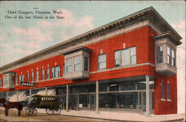
Hoquiam was officially incorporated on May 21, 1890. Its name is taken from a Native-American language meaning "Hungry for wood". The logging and lumber business peaked during the late 1920s, although the area has continuing lumber industry ties. The Logger's PlayDay is an annual event held every September, featuring a parade, and tree-topping, log rolling, ax-throwing and choker-setting competitions. circa 1910.
Printed on front: Hotel Grayport, Hoquiam, Wash. One of the best Hotels in the State.
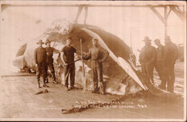
Men standing around and on a very large whale in Cosmopolis, Washington. Cosmopolis is a small city in Grays Harbor County. The Chehalis River runs parallel to the main drag, and the area is well known for its sturgeon fishing and its ties to the lumber industry. circa 1912.
Printed on front: A 60 Ton Humpback Whale 60 foot long, 45 foot around.
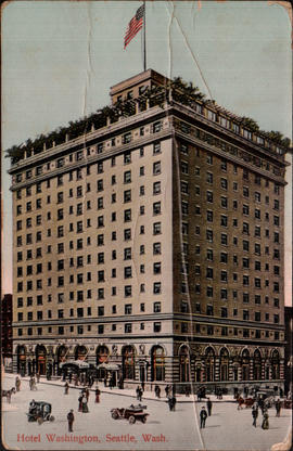
This view is actually of the New Washington Hotel, at the corner of Second and Stewart. The hotel was developer James Moore's response to losing his Gothic landmark, the original Washington Hotel, to the Denny regrade. (His namesake Moore Theatre is directly behind the hotel.) The New Washington opened in 1908, was purchased by the Catholic church as a retirement home in 1963, added to the National Historic Register and given local Landmark status in 1989--and was turned into low income housing in 1990. It is now called the Josephinum/New Washington Hotel. circa 1910.
Printed on front: Hotel Washington, Seattle, Wash.
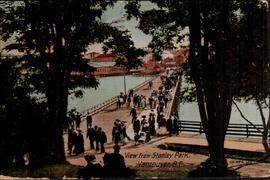
Stanley Park, in Vancouver, British Columbia, Canada. In the 1860's, the area was used as a military reserve before being designated as a park in 1886 by the Dominion of Canada. The park was named after Lord Stanley, Governor General of Canada. Today the park covers over 1,000 acres, and is the third largest city-owned park in North America. circa 1912.
Printed on front: View from Stanley Park, Vancouver, B.C.
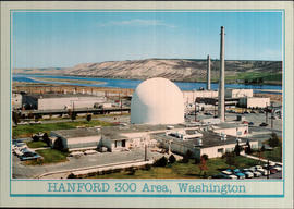
In January 1943, Hanford was chosen by the Federal government as the site for the world�s first full-scale plutonium production plants. It was considered an ideal place because of the remote location, the access to railroad systems, the proximity to the Columbia River needed for cooling the reactors, and the abundance of hydroelectric power generated from dams along the river. The Hanford 300 Area was constructed and operated as a reactor fuel fabrication and laboratory complex. circa 1970.
Printed on back: Hanford Works U.S. Atomic Energy Commission Reservation This atomic energy installation is a major testing center for the nation's top priority energy programs.
Message: Dear Candy--It is so very hot here stays so in the room all the time so far-Back is much better am just going out for some breakfast-It is nearly noon. May ? today- hope it's cooler up there. Love to all, Connie
Addressee: Mrs. Herb Irving Aberdeen Ave. Hoquiam, Wash.
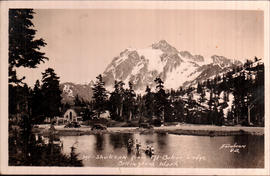
Mount Shuksan, in North Cascades National Park, looms above either Highwood Lake or Picture Lake, which are located in Mount Baker-Snoqualmie National Forest. Mount Shuksan is located east of Mount Baker, and south of the Canadian border. circa 1944.
Printed on front: Mt. Shuksan from Mt. Baker Lodge Bellingham, Wash.
Printed on front: Mt. Shuksan from Mt. Baker Lodge Bellingham, Wash.
Young woman in bright shawl and festive hat, knocking on a door decorates this greeting card. In addition to colorful flowers on the front of the card, there are drawings of birds, ribbons and flowers on the back. circa 1917.
Printed on front: Birthday Greeting A very Happy Birthday, and when you cut your cake Please cut a little piece for me, For good old Friendship sake.
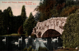
Beacon Hill Park was turned over to the City of Victoria in 1882. Beacon Hill Park also has an important status as the western terminus, the Mile "0" of the 8,000 kilometer Trans-Canada Highway. The park overlooks the Juan de Fuca Strait and the Olympic Mountains in Washington State. circa 1915.
Printed on front: Bridge and Swans, Beacon Hill Park, Victoria, B. C.
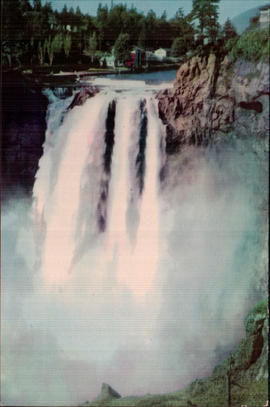
Snoqualmie Falls is a 268 ft. waterfall on the Snoqualmie River between Snoqualmie and Fall City, Washington. It is one of Washington's most popular scenic attractions. circa 1945.
Signs proclaiming, "See our miniature wonderland", "Gifts, Trains, Models" and "Model Railroad display" sit outside the Northwestern House of Hobby's, located between Tacoma and Seattle, likely on Highway 99. circa 1950.
Printed on front: House of Hobby's-Midway-Seattle-Tacoma Highway
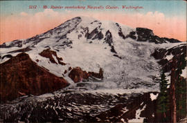
The Nisqually Glacier is one of the larger and glaciers on the southern face of Mount Rainier, and one of the most easily viewed on the mountain. It is accessible from the Paradise visitor facilities in Mount Rainier National Park. circa 1915.
Printed on front: Mt. Rainier overlooking Nisqually Glacier, Washington.