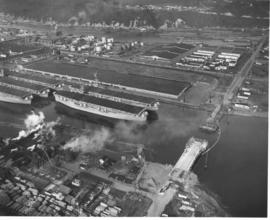
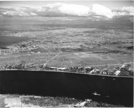
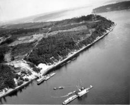
ca. 1953. This aerial view of the northeast section of the Tacoma tideflats from 1953 shows part of the Port of Tacoma, lower left, and the 185-acre Port Industrial Yard which was acquired by the Port in 1959. Five mothballed WWII baby flattops are moored in the Port Industrial Waterway. The incomplete Port Industrial Waterway bridge, later named the Blair Bridge, can be seen at the right. The bridge opened for traffic on November 14, 1953. The bridge is 712 feet long with a 40 foot roadway and 5 feet of sidewalk on one side only. It has a clearance at high tide of 12 feet. There is a 150 foot channel between the main piers for the passage of shipping vessels. The two main channel piers are 45 x 55 foot and house the operating machinery, counterweights and electrical equipment for opening and closing the span drawbridge. They are the equivalent in height, measured both above & below the water, to a seven story building. The cost of the bridge was $1,600,000. (TNT 11/13/1953, special section #D)
Aerial photographs; Port of Tacoma (Tacoma)--1950-1960; Aircraft carriers--Tacoma--1950-1960; Harbors--Tacoma; Aerial views; Blair Bridge (Tacoma); Port Industrial Waterway Bridge (Tacoma); Vertical lift bridges;
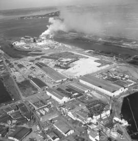
Smoke could be seen day and night billowing from the St. Regis Paper Co. facility on Tacoma's industrial Tideflats. Aerial view taken in late June, 1966, shows that the area continued to grow with new construction. St. Regis was located conveniently between the Puyallup and St. Paul Waterways. Photograph ordered by St. Regis Paper Co.
Aerial photographs; St. Regis Paper Co. (Tacoma)--1960-1970; Smoke--Tacoma;
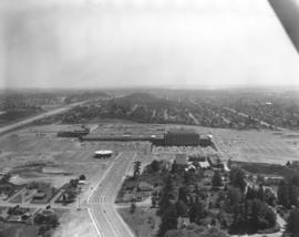
The Bon Marche was no longer the only occupant of the Tacoma Mall Shopping Center on the south side of Tacoma in October,1965 when this aerial photograph was taken. A full-line J.C. Penney's had opened at the southeast end of the large building complex and many smaller specialty stores had joined the two large department stores. Acres of free parking proved to be a major draw, and the enclosed mall design kept customers out of the wind and rain. The National Bank of Washington's circular building is prominent near the Mall; I-5 freeway, providing easy access to the Mall, runs along the photograph's left side. The Wapato Lake area is southeast of the Mall to the left of I-5, near the horizon. Most of the residential development surrounding the Mall has been converted over the years into commercial property.
Aerial photographs; Shopping centers--Tacoma; Bon Marche (Tacoma); National Bank of Washington (Tacoma); J.C. Penney Co. (Tacoma);
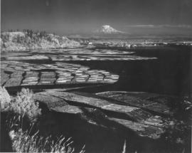
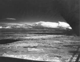
ca. 1943. Mount Rainier rises ghostlike above the Hylebos Waterway in this test photograph with the new infrared film. Log booms make designs in the water leading up to the Tideflats. Foliage has an eerie white glow. The photograph is believed to have been taken from the vicinity of the Cliff House.
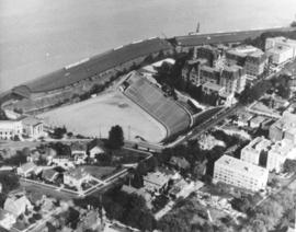
ca. 1971. This is an aerial view of the Stadium district as photographed circa 1971. Stadium Bowl is in the center with Stadium High School on the right and the Washington State Historical Society Museum on the left. Stadium Bowl, built in 1909, has been renovated circa 1980 and been subjected to several damaging mudslides in 1932, 1949, and 1981. It now has a modern capacity of 15,000, downsized from its original seating capacity of 23,486. Stadium Bowl was originally designed by Tacoma architect Frederick Heath. BU-11652
Aerial photographs; Aerial views; Neighborhoods--Tacoma--1970-1980; Stadium Bowl (Tacoma); Stadium High School (Tacoma); Washington State Historical Building (Tacoma);
This aerial view of McChord Field from June of 1940 shows the U.S. Army's Northwest airbase shortly before it was dedicated on July 3rd. The massive building in the center is the new enlisted men's barracks which could house 1,200 men. In the upper right corner are two of the six-story tall hangers that housed the base's fleet of 24 Douglas B-18A "medium" bombers. The Army had already spent $7 million building the airbase, and millions more would be needed before it was completed. (T.Times 7/1/1940 p.1)
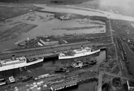
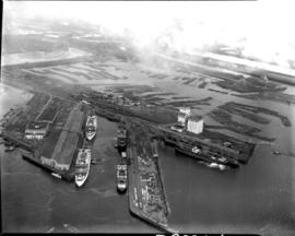
In this aerial photograph from January 1940, two white Navy transport ships sit at dock in Slip No. One of the Port Industrial Waterway waiting to take on soldiers from Fort Lewis. On Friday January 13th, 7,500 soldiers boarded three transport ships to be carried to California to take part in the largest Army-Navy "war games" exercise ever held on U.S. soil, to that date. When the ships pulled out Saturday morning, Fort Lewis was virtually deserted; only a maintenance staff of a few hundred men stayed behind. (T. Times 1/11/1940, pg. 1)
Aerial photographs; Bays--Washington (State); Commencement Bay (Wash.); Port of Tacoma (Tacoma)--1940-1950; Logs; Ships;
Aerial view of Port Piers on January 13, 1940, showing transport ships. Log booms in background. The three larger vessels are the military transport ships, the Hunter Liggett, Leonard Wood and St. Mihiel. They will be boarding 7500 soldiers from Fort Lewis and taking them to join the 3rd Division Black Army at sea. During the upcoming war games, the Black Army will invade the coast of California from the sea. The games are the largest in US history and involve both the Army and Navy. In 1940, the military was looking ahead to possible involvement in the European conflict which would become World War II. (T. Times 1/11/1940, pg. 1)
Aerial photographs; Bays--Washington (State); Commencement Bay (Wash.); Port of Tacoma (Tacoma)--1940-1950; Logs; Ships;
This aerial view, taken January 13, 1940, shows the Port of Tacoma piers with two docked, white transport ships. Three transport ships, the Hunter Liggett, Leonard Wood and St. Mihiel, were in Commencement Bay to transport over 7,500 soldiers from Fort Lewis to the biggest war games in US history. This is the biggest passenger embarkation in the history of the Tacoma port. The troops will invade the California coast from the sea. They will strike at an undisclosed location somewhere on the 400 mile coast between San Francisco and Santa Barbara. This will be the major offensive of the war games to be held January 15-22nd. Also in the photograph are the Co-op's white grain elevators; the waterway is crowded with log booms. The two other cargo vessels pictured are believed to be the South American freighter Coya and the Japanese freighter Koei Maru. ( T. Times 1-3-40, p. 1-article; 1-11-40, p.1-article; 1-13-40, p.1-article)
Aerial photographs; Bays--Washington (State); Commencement Bay (Wash.); Port of Tacoma (Tacoma)--1940-1950; Logs; Ships; Piers & wharves--Tacoma--1940-1950;
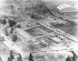
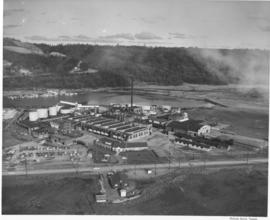
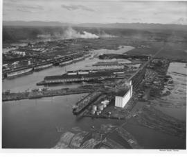
An aerial photograph of the sprawling Pennsylvania Salt Manufacturing Co. of Washington was taken in October, 1954. The Tacoma plant, whose parent company was founded over one hundred years ago in Natrona, Pennsylvania, has been at its 40 acre Tideflats location on the Hylebos waterway since 1929. Throughout the years, it has undergone rapid expansion of its facilities and also its product lines. Despite its name, it has no connection with the manufacture of table salt. Photograph ordered by Pennsylvania Salt Manufacturing Co. of Washington.
Aerial photographs; Pennsylvania Salt Manufacturing Co. of Washington (Tacoma); Chemical industry--Tacoma--1950-1960; Hylebos Waterway (Tacoma);
ca. 1939. Associated Oil Company aerial view of Tacoma West End from Day Island to Point Defiance and beyond. Piers for first Narrows Bridge under construction. Ordered by George Martinac, North Pacific Bank Note.
ca. 1939. Associated Oil Company aerial view of Tacoma, West End to Downtown, tideflats and beyond. Piers for first Narrows Bridge under construction. Ordered by George Martinac, North Pacific Bank Note.
Associated Oil Company aerial view looking south toward Lakewood. Cemetery and highway in foreground. Ordered by George Martinac, North Pacific Bank Note Company.
ca. 1939. Associated Oil Company aerial view of Tacoma West End showing area above Titlow Beach and Day Island. Photograph taken circa 1939. Ordered by George Martinac, North Pacific Bank Note Company.
Associated Oil Company aerial view of Northeast Tacoma, Vashon Island, and Commencement Bay. Ordered by George Martinac, North Pacific Bank Note Company.
ca. 1939. Associated Oil Company aerial view of west side cement plant and construction of west pier for first Narrows Bridge. Ordered by George Martinac, North Pacific Bank Note. TPL-6712
Associated Oil Company aerial view of west side cement plant and construction of west pier for first Narrows Bridge. Ordered by George Martinac, North Pacific Bank Note.
ca. 1939. Associated Oil Company aerial view of west side cement plant for first Narrows Bridge construction. Ordered by George Martinac, North Pacific Bank Note.
ca. 1939. Aerial view from the Narrows of Tacoma's West End with downtown and the Tideflats beyond. Running down the center of the photograph is Sixth Ave. as it veers off to Titlow Beach in the lower right hand. It is crossed by Pearl Street, where the excavation for (what is believed to be) a planned Tacoma airport forms a pattern on the ground. The area is largely undeveloped. Construction on the Narrows Bridge (Galloping Gertie) had begun but was far from completion. For a 1961 aerial view of the same location, see D129800, images 43 & 131. TPL-9156
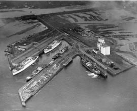
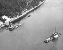
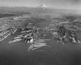
Aerial view of Tacoma industrial Tideflats in 1954 with major focus on the Port Industrial Waterway. Mothballed WWII flattops are positioned close to the U.S. Naval Station. A collection of log booms are amassed in the Sitcum Waterway. The tip of Mount Rainier can be spotted at the top of the photograph.
Aerial photographs; Port of Tacoma (Tacoma)--1950-1960; Sitcum Waterway (Tacoma); Port Industrial Waterway (Tacoma); Logs; Rainier, Mount (Wash.);
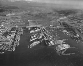
Aerials of the Port of Tacoma, c. 1954. The Port Industrial Waterway takes up most of the photograph with the mothballed WWII flattops stored in readiness for combat activation next to the U.S. Naval Station. The round storage tanks at Hooker Electrochemical can be seen behind the fleet of ships. The Port of Tacoma fingertip piers lie along the other side of the Waterway. The round storage tanks of Time Oil Co. and the Port of Tacoma Grain Elevators occupy the tip of land jutting out between the Port Industrial Waterway and the Sitcum Waterway. TPL-2250
Aerials of the Port of Tacoma, circa 1954, with Mount Rainier in the background. From left to right lies the U.S. Naval Station with the mothballed fleet of flattops, kept in readiness, on the Port Industrial Waterway. The fingertip piers of the Port of Tacoma can also be seen on the Industrial Waterway. The Port of Tacoma grain elevators lie at the tip of land facing the Sitcum Waterway. The large, almost rectangular Sitcum Waterway holds many log booms. Tacoma Boat Building's tall sheds for drydock can be seen on the other side of the waterway. The smaller Milwaukee Waterway separates the Henry D. Gee Co. Grain Storage and the Puget Sound Freight Lines. TPL-2255
Aerial views; Port of Tacoma (Tacoma)--1950-1960; Rainier, Mount (Wash.); Port Industrial Waterway (Tacoma); Sitcum Waterway (Tacoma);
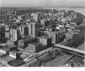
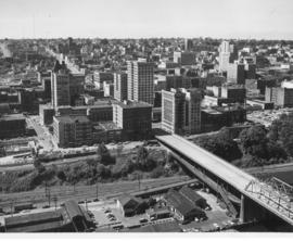
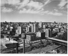
Aerial of downtown Tacoma looking west from the Eleventh Street Bridge. The bridge crosses the City Waterway and provides transportation from the commercial downtown area to the industrial area.
Aerial photographs--1950-1960; Business districts--Tacoma--1950-1960;
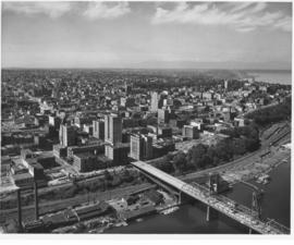
Aerial of downtown Tacoma looking west from the Eleventh Street Bridge. The Dock Street Steam Plant can be seen at lower left. Railroad tracks and a green belt divide the commercial downtown area from the waterfront. The bridge crosses over the City Waterway into the industrial area.
Aerial photographs--1950-1960; Business districts--Tacoma--1950-1960;
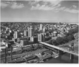
Aerial of downtown Tacoma looking west from the intersection of 11th & A Streets. The Dock Street Steam Plant can be seen in the left hand foreground and the Eleventh Street Bridge on the right. The Eleventh Street Bridge crosses the City Waterway and leads to the Tideflats and Port of Tacoma industrial areas.
Aerial photographs--1950-1960; Business districts--Tacoma--1950-1960; 11th Street Bridge (Tacoma); Commercial streets--Tacoma--1950-1960;
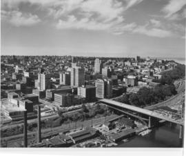
This is an aerial of downtown Tacoma looking west from 11th and A street as it appeared in August of 1953. Beginning span of the 11th Street Bridge at lower right corner and smoke stacks from Dock Street Steam plant at lower left.
Aerial photographs--1950-1960; Business districts--Tacoma--1950-1960; 11th Street Bridge (Tacoma); Bridges--Tacoma--1950-1960; Commercial streets--Tacoma--1950-1960;