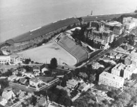
ca. 1971. This is an aerial view of the Stadium district as photographed circa 1971. Stadium Bowl is in the center with Stadium High School on the right and the Washington State Historical Society Museum on the left. Stadium Bowl, built in 1909, has been renovated circa 1980 and been subjected to several damaging mudslides in 1932, 1949, and 1981. It now has a modern capacity of 15,000, downsized from its original seating capacity of 23,486. Stadium Bowl was originally designed by Tacoma architect Frederick Heath. BU-11652
Aerial photographs; Aerial views; Neighborhoods--Tacoma--1970-1980; Stadium Bowl (Tacoma); Stadium High School (Tacoma); Washington State Historical Building (Tacoma);
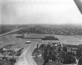
The Bon Marche was no longer the only occupant of the Tacoma Mall Shopping Center on the south side of Tacoma in October,1965 when this aerial photograph was taken. A full-line J.C. Penney's had opened at the southeast end of the large building complex and many smaller specialty stores had joined the two large department stores. Acres of free parking proved to be a major draw, and the enclosed mall design kept customers out of the wind and rain. The National Bank of Washington's circular building is prominent near the Mall; I-5 freeway, providing easy access to the Mall, runs along the photograph's left side. The Wapato Lake area is southeast of the Mall to the left of I-5, near the horizon. Most of the residential development surrounding the Mall has been converted over the years into commercial property.
Aerial photographs; Shopping centers--Tacoma; Bon Marche (Tacoma); National Bank of Washington (Tacoma); J.C. Penney Co. (Tacoma);
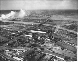
Aerial view of West Coast Grocery, St. Paul and Tacoma lumber and Tacoma Iron and Steel. A view of the Tacoma tideflats and some of the industry built on it looking north.
Ponder Sales & Service Inc. sold diesel stove and heavy fuel oils. They were located at 764 Commerce Street. Aerial view ordered by Ponder Sales and Service Co.
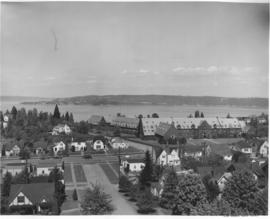
Annie Wright Seminary was a college preparatory school for girls. Miss Ruth Jenkins was the headmistress of the school. Aerial view of Annie Wright Seminary, Commencement Bay in background.
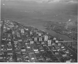
Aerial views of city. This view of downtown is looking north with the high-rise office buildings shown climbing the hill to the west. The 11st Street Bridge crosses the City Waterway on the far right with the industrial Tacoma tideflats on the other side. The Puyallup River enters into Commencement Bay and has left a noticeable line where the fresh water meets the salt. Several ships are docked at Shaffer Terminals lying on the west side of the City Waterway.
Aerial photographs; Cityscapes; Bays--Washington (State); Commencement Bay (Wash.); City Waterway (Tacoma); Rivers--Washington (State); Puyallup River (Wash.); 11th Street Bridge (Tacoma);
Miscellaneous aerials, Port Piers, Schaeffer Terminal, Tacoma Lumber Fabricating Company. An aerial view of an industrial building site in Tacoma. The area has been leveled and forms are in place to begin pouring concrete. This is believed to be the location of the new facilities for Tacoma Drug Company. Another building in the background is nearly finished with the covering being added to the barrel roof.
Aerial photographs; Building construction--Tacoma--1940-1950; Reinforced concrete construction--Tacoma--1940-1950;
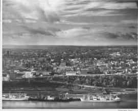
Aerial photographs. This is a view, taken in October of 1948, of the downtown business district of Tacoma, the 11th Street Bridge to the Tacoma tideflats, Commencement Bay and Brown's Point as the bay joins Puget Sound. Vashon Island is in the distance.
Aerial photographs; Cityscapes; Commencement Bay (Wash.); Business districts--Tacoma--1940-1950;
This aerial view of Tacoma looking west was taken in October of 1948. Several ships are docked at the Shaffer Terminals in the immediate foreground. The railroad tracks run along the lower shore with the railroad bridge clearly visible. The commercial district of Tacoma is seen to the left on higher ground. The tall building with a tower near the middle left is the Pierce County Courthouse at 1014 South G Street. Other discernable structures include the Tacoma Elks Temple at left foreground and in the distance to the right, the Tacoma General Hospital complex. The residential areas of the city spread out in the background.
Aerial photographs; Cityscapes; Tacoma General Hospital (Tacoma); Pierce County Courthouse (Tacoma); Benevolent and Protective Order of Elks, Tacoma Lodge No. 174 (Tacoma); Piers & wharves--Tacoma--1940-1950; Bridges--Tacoma;
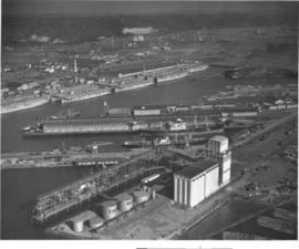
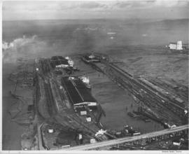
Miscellaneous aerials, Port Piers, Schaeffer Terminal, Tacoma Lumber Fabricating Company. A 1948 aerial view of the Port of Tacoma including the Port piers and the grain elevators. Time Oil storage tanks are seen in front of the grain elevators. Baby flattops (smaller aircraft carriers) were mothballed in Tacoma after the end of World War II in the Port Industrial Waterway. TPL-8305
Aerial photographs; Port of Tacoma (Tacoma)--1940-1950; Aircraft carriers--Tacoma--1940-1950; Harbors--Tacoma; Marine terminals--Tacoma--1940-1950; Shipping--Tacoma--1940-1950;
Aerial photographs. This view shows ships tied along the Shaffer Terminal facilities at Milwaukee Waterway.The Chicago, Milwaukee and St. Paul Railway Terminal is across the waterway on the east. East 11th Street crosses the bottom of the photograph. Log booms have been tied up along the left side (part of the Puyallup Waterway). The Port of Tacoma elevators are on the right. Freighters are seen in Commencement Bay awaiting space to tie up. Browns Point is across the bay before it enters Puget Sound.
Aerial photographs; Shaffer Terminals, Inc. (Tacoma); Marine terminals--Tacoma;
South Tacoma was featured in the Tacoma Times Labor Day Industrial pages, the area was rapidly expanding and contributing many new jobs and homes to Tacoma community members. Aerial view of available area, neighborhoods and the Star-Lite Park In Theatre (background), all located along South Tacoma Way (T. Times, 8/31/48, p. 21).
Cities & towns--Tacoma; City & town life--Tacoma; Aerial views; Aerial photographs; Neighborhoods--Tacoma; Drive-in theaters--Tacoma; Star-Lite Park In Theatre (Tacoma); South Tacoma Way (Tacoma);
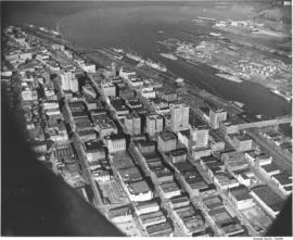
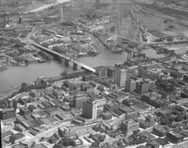
This is an aerial southeastern view of the downtown Tacoma business district and portion of the industrial Tideflats that was taken in August of 1948. Two boats are approaching the 11th Street Bridge (now Murray Morgan Bridge), left center, as it extends over the City (now Thea Foss) Waterway. The two bridges pictured to the right of the Murray Morgan Bridge have since been removed. Prominent structures also include the 17-story, Art Deco-styled Medical Arts Building (now Tacoma Municipal Building) on Market St., the massive Washington Building and Puget Sound National Bank with its spire, both on Pacific Avenue.
Aerial photographs; Bridges--Tacoma--1940-1950; 11th Street Bridge (Tacoma); Business districts--Tacoma--1940-1950; City Waterway (Tacoma); Puget Sound National Bank (Tacoma); Washington Building (Tacoma); Medical Arts Building (Tacoma);
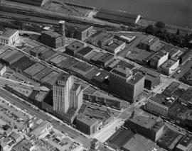
View by air of downtown business district taken in August 1948; includes Market, Broadway, and Commerce streets. Many prominent commercial structures are clearly visible including the 17-story Medical Arts Building on Market St., the uniquely-shaped Bostwick Building, Winthrop Hotel on Broadway, Elks Club and (Old) City Hall found in upper left. Glimpses can be spotted of the sandstone tower of First Baptist Church at bottom of photograph, the Rialto theater, the turret of the Music Box theater and the Roxy (Pantages) nearby.
Aerial photographs; Commercial streets--Tacoma--1940-1950; Business districts--Tacoma; Medical Arts Building (Tacoma); (Old) City Hall (Tacoma); Elks Club (Tacoma); Hotel Winthrop (Tacoma);
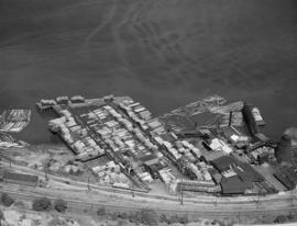
Dickman Lumber Co. August, 1948, aerial view of plant operations at the Dickman Lumber Co., 2423 Ruston Way, with focus on log booms and stacked lumber. Dickman Lumber was established in 1889 by Abraham Coon Young as the Young Bros. Shingle Mill and was later purchased by Leonard Howarth and Ralph L. Dickman, Sr., in 1922, subsequently being renamed the Dickman Lumber Co. The finished products turned out by the mill were not only used locally but shipped to countries around the world. Dickman Lumber's operations on Ruston Way were closed in September, 1977, and the mill was gutted by fire in January, 1979. Its ruins were demolished in 1997. (History of Pierce County, Vol. 1, p. 11-13)
Logs are kept ready for the St. Paul & Tacoma Lumber Co. operations in convenient log booms. This August, 1948, aerial photograph shows logs floating in the Puyallup and other waterways. Established in 1888, St. Paul & Tacoma had extensive holdings in the Tideflats, sprawling on both sides of East 11th St. They would merge with St. Regis Paper Co. in 1957.
Aerial photographs; Logs; Puyallup Waterway (Tacoma); St. Paul & Tacoma Lumber Co. (Tacoma);
Aerial view of business district in Tacoma, office rooftops; photo ordered by Columbia Breweries, possibly to display prominent Tacoma buildings in their future, newly remodeled facilities.
This aerial view of Tacoma, encompassing the buildings between South 9th and South 12th Streets (left to right) and Fawcett and Yakima Avenues (top to bottom), was taken in August of 1948. The building shaped like a large inverted "U" at the bottom right is the Tacoma Vocational School (now Bates). It was undergoing its first expansion since it was originally built in 1941. The old Pierce County Courthouse dominates the center of the picture, with the Armory to its left. Most of the buildings in this the center of this photograph, including the church partially hidden by the courthouse tower, were demolished in the 1950s to make way for the County-City Building which was dedicated in April 1959.
Aerial photographs; State Armory (Tacoma); Pierce County Courthouse (Tacoma); First Presbyterian Church (Tacoma); Tacoma Vocational School (Tacoma);
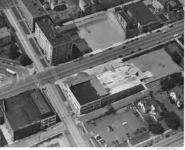
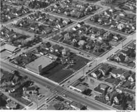
Aerial photograph of Sixth Avenue. This aerial photograph of Sixth Avenue near Union shows how the nearby streets are neatly partitioned into grids with well-kept homes and businesses. Near the center of the photograph is the new Tradewell supermarket #30 with its large tower jutting into the sky and expansive parking lot. On the next block a portion of the new Sixth & Washington Square Building can be seen. Photograph ordered by Carl Swanson, Tradewell Stores, Inc.
Aerial photographs; Tradewell Stores, Inc. (Tacoma); Sixth & Washington Square Building (Tacoma);
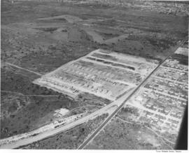
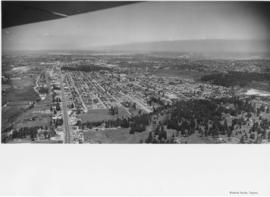
Aerial photographs. The wing of an airplane is visible as aerial photographs were taken of the South Tacoma and possibly other local areas on June 15, 1953. The photo appears to be looking north toward Vashon Island. There is a gravel pit to the right. There were still large areas of undeveloped and wooded land at this time in Tacoma's history. Photograph ordered by North Pacific Bank.
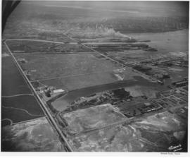
Aerial view of the Tacoma tideflats and Port of Tacoma. Lincoln Ave. runs up the left hand side of the picture and East 11th Street with its partially completed bridge on the right. The smaller body of water in the foreground is the Port Industrial Waterway, the one in the back is Hylebos Waterway and the large body of water on the right is Commencement Bay. The stored baby flattops and the Port of Tacoma can be seen on the right by the bridge. The vacant area is 1500 acres of vacant industrial land that the city hoped would turn Tacoma into the industrial center of the West.
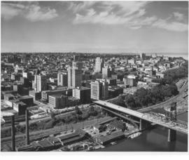
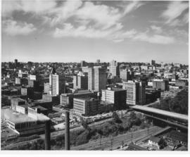
Aerial of downtown Tacoma looking west from the Eleventh Street Bridge. The Dock Street Steam Plant can be seen at lower left. Railroad tracks and a green belt divide the commercial downtown area from the waterfront. The bridge crosses over the City Waterway into the industrial area.
Aerial photographs--1950-1960; Business districts--Tacoma--1950-1960;
This is an aerial of downtown Tacoma looking west from 11th and A street as it appeared in August of 1953. Beginning span of the 11th Street Bridge at lower right corner and smoke stacks from Dock Street Steam plant at lower left.
Aerial photographs--1950-1960; Business districts--Tacoma--1950-1960; 11th Street Bridge (Tacoma); Bridges--Tacoma--1950-1960; Commercial streets--Tacoma--1950-1960;
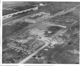
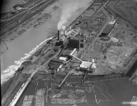
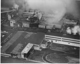
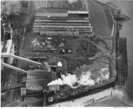
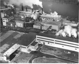
An aerial view of the new multiwall bag plant at St. Regis. The plant was completely equipped to produce a full range of multiwall bags. Equipment included six production lines, three printing presses, a complete art and engraving department and auxiliary equipment. This plant replaced a leased plant in Seattle. (TNT, 10/19/1952)
St. Regis Paper Co. (Tacoma)--1950-1960; Aerial photographs; Mills--Tacoma--1950-1960; Paper industry--Tacoma--1950-1960;
An aerial view on February 16, 1952, showing the new multiwall bag plant at St. Regis. St. Regis also had other bag plants on the Pacific Coast at Los Angeles and San Leandro, California. The company also maintained complete engineering and service facilities for automatic bag filling equipment, including a machine shop at Los Angeles, and packer sales and engineering offices at San Francisco and Seattle. The company was self-contained on the west coast. (TNT, 10/19/1952)
St. Regis Paper Co. (Tacoma)--1950-1960; Aerial photographs; Mills--Tacoma--1950-1960; Paper industry--Tacoma--1950-1960;
An aerial view of the new multiwall bag plant at St. Regis. The expansion of the bag plant facilities by St. Regis reflected the continuing trend of industry and agriculture to use the multiwall shipping sack. It was estimated that approximately 2 1/2 billion multiwall bags were used in 1951 for all types of products, compared with less than half a billion in 1938. The multiwall bag came into general use as an industrial container in the mid 1920's and was used for packaging cement and other rock products. Shortly thereafter is was adopted by the sugar industry. (TNT, 10/19/1952)
St. Regis Paper Co. (Tacoma)--1950-1960; Aerial photographs; Mills--Tacoma--1950-1960; Paper industry--Tacoma--1950-1960;
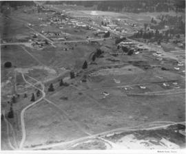
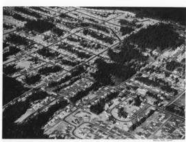
Aerial photographs of Mountlake Terrace were taken on August 16, 1951. Developers of this neighborhood near Seattle left many of the trees in the heavily forested area for homeowners to enjoy. Cul-de-sacs were starting to emerge as part of suburban lifestyles, to lessen amount of traffic on roads next to homes and provide safer play areas for children. Photograph commissioned by Budget Homes, Inc.