Showing 824 results

Collections
Aerial Photography Image With digital objects
Print preview View:

D157046-7

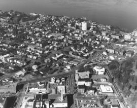
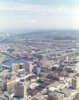
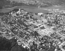
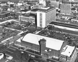
County-City Building. Close-up view of the County-City Building with two its wings - law enforcement on the left and courts on the right with the 12-story central structure between. Also in this October 4, 1969, aerial view is the Washington National Guard Armory in the photograph's foreground. The brick edifice was dedicated on the first day in January, 1909, and remodeled several times since then. Located in the 700 block of So. 11th St., it was across the street from the L.H. Bates Vocational-Technical Institute (formerly Tacoma Vocational). Photograph ordered by Whitacre Engineers.


Aerial views; County-City Building (Tacoma); State Armory (Tacoma); Commercial streets--Tacoma--1960-1970;

D157214-123

Aerial view of industrial Tideflats area around East D St. between City (now Thea Foss) Waterway and Middle Waterway on October 16, 1969. Fick Foundry (center) had long been an occupant at 1005 East D with Richfield Oil across the street. The building right of Fick is the Junior Line Furniture Co., 1017 East D. The large plant above Fick Foundry is the Coast Sash & Door Co., 1002 East F St. It was later known as Coastcraft. Photograph ordered by Winston Fournier & Associates, Dallas. (Additional identification provided by a reader) TPL-10293


Aerial views; Fick Foundry Co. (Tacoma); City Waterway (Tacoma); Middle Waterway (Tacoma); Commercial streets--Tacoma--1960-1970; Coast Sash & Door Co. (Tacoma); Junior Line Furniture Co. (Tacoma); Richfield Oil Corp. (Tacoma);

D157837-10

Aerial look of the populous North end and downtown area of Tacoma in 1970, including glimpse of Commencement Bay and bustling industrial Tideflats. This view is looking east over the city's landscape. I-5 is toward the right corner. University of Puget Sound is in the center. Photograph ordered by Puget Sound National Bank. TPL-9668


Aerial views; Neighborhoods--Tacoma--1970-1980; University of Puget Sound (Tacoma)--1970-1980; Commencement Bay (Wash.);

D157837-2

On February 20, 1970, several aerial photographs of North Tacoma were taken on behalf of Puget Sound National Bank. They showed the north end residential neighborhoods extending to Commencement Bay. The beautiful campus of the University of Puget Sound and adjacent Baker Stadium and Fieldhouse are located in the lower left-center. Wright Park is the large wooded area close to downtown Tacoma.


Aerial views; University of Puget Sound (Tacoma)--1970-1980; Wright Park (Tacoma); Commencement Bay (Wash.);

D157837-27

A February, 1970, photograph taken on a sunny winter day looking north toward Commencement Bay showed the north end Stadium District. Wright Park, located around Sixth & "I," is on the right lower edge. Across the street from the park is the Greek-ionic styled First Church of Christ, Scientist. The Washington State Historical Society building, Stadium Bowl and Stadium High School are near the right upper edge. The white tower in the upper center is the Vista Manor Apartments; built in 1950, Vista Manor had some outstanding views of the bay. Next door to the Vista Manor at 409 Tacoma Ave. No. is the Central Lutheran Church. A portion of Tacoma General Hospital can be seen at the bottom of the photograph. Photograph ordered by Puget Sound National Bank.


Aerial views; Wright Park (Tacoma); First Church of Christ, Scientist (Tacoma); Stadium High School (Tacoma); Stadium Bowl (Tacoma); Washington State Historical Society Building (Tacoma); Vista Manor Apartments (Tacoma); Commencement Bay (Wash.);

D159700-243C

1971 color Richards stock footage. Aerial northeast view of downtown Tacoma overlooking City (now Thea Foss) Waterway and industrial Tideflats. The snowy tip of Mount Rainier is barely visible through the haze. Wheeler-Osgood Waterway is the small waterway on the left which leads into the City Waterway. Major buildings of note in downtown area include Tacoma and Perkins Buildings flanking the 11th Street Bridge (now Murray Morgan Bridge); the cluster of buildings on Pacific including Washington and Rust Buildings, Puget Sound National Bank, the new Bank of Washington Plaza, and Schoenfelds Furniture to the right. Neighborhoods seen in the distance to the center and right of photograph are part of East Tacoma.


Aerial views; City Waterway (Tacoma); Wheeler-Osgood Waterway (Tacoma); Tacoma Building (Tacoma); Perkins Building (Tacoma); Washington Building (Tacoma); Rust Building (Tacoma); Puget Sound National Bank (Tacoma); 11th Street Bridge (Tacoma);

D159700-244C

1971 color Richards stock footage. Aerial view of Point Defiance and vicinity. The Point Defiance Park is on the right with the Boathouse prominently displayed. The ferry landing and Tacoma Yacht Club and mooring are in the upper center. ASARCO (American Smelting & Refining Co.) is near the top with a glimpse of the giant smokestack along the right upper edge.


Aerial views; Point Defiance Park (Tacoma); Parks--Tacoma--1970-1980; Boathouses--Tacoma; Boats; Tacoma Yacht Club (Tacoma); Mooring; American Smelting & Refining Co. (Tacoma); Smelters--Tacoma--1970-1980;

D160364-5

Aerial view on June 2, 1971, of Tacoma's north end. Standing tall in the trees at lower center is one of the Cushman towers. Vassault Park is positioned between Vassault and Pearl Streets in the center of the photograph. The curving roadway, intersected by both Vassault and Pearl, is the Narrows which will become North 26th St. Along North 30th, above Pearl, is the North End water tower and reservoir. Commencement Bay is at top of photograph; ASARCO smelter is along its shoreline. Photograph ordered by Puget Sound National Bank.


Aerial views; Neighborhoods--Tacoma--1970-1980; Vassault Park (Tacoma); Water towers--Tacoma; Reservoirs--Tacoma; Electric lines--Tacoma; Commencement Bay (Wash.); Smelters--Tacoma;

D160364-28

Aerial photograph of Burlington Northern railroad tracks around North 48th St. on June 2, 1971. The curved street through the trees that passes under the railroad tracks is North 48th St. The spurline to Ruston is in the right corner edge. Photograph ordered by Puget Sound National Bank.


Aerial views; Railroad tracks--Tacoma--1970-1980; Neighborhoods--Tacoma--1970-1980;

D160622-1

Aerial views of industrial Tideflats and waterways. On June 25, 1971, a Richards Studio photographer took a series of photographs of some of Tacoma's waterways. With Mount Rainier barely visible amidst fog, the landscape is clearer at the mouths of the waterways. From L-R are the long Puyallup Waterway, St. Paul Waterway, and Middle Waterway. Smoke is shown billowing from the St. Regis facility. Photograph ordered by Foss Tug & Barge.


Aerial views; Rainier, Mount (Wash.); Puyallup Waterway (Tacoma); St. Paul Waterway (Tacoma); Middle Waterway (Tacoma); St. Regis Paper Co. (Tacoma)--1970-1980;

C160915-1C

ca. 1971. Aerial view of former Tacoma Sports Arena with artist's rendering of possible architectural changes. Ben's Truck Parts had purchased the Tacoma Sports Arena (known prior as the Tacoma Ice Palace) on September 3, 1971. The company had commissioned the Richards Studio to take several aerial photographs of the Arena and vicinity. This aerial view shows possible architectural changes to the building and site with shimmering pools facing So. 38th St. and a profusion of trees and shrubs added. The exterior of the building would also change with walls apparently extended and a changed roofline. The location was easily accessible by traveling on So. 38th St. (now one of the city's busiest streets due to the close proximity to the Tacoma Mall), South Tacoma Way, and from the north, Union Ave. Color photograph ordered by Ben's Truck Parts.


Aerial views; Renderings; Tacoma Sports Arena (Tacoma); Tacoma Ice Palace (Tacoma);

D161273-15

This aerial view of the Puyallup neighborhoods near 112th & Meridian was taken by the Richards Studio on January 2, 1972, on behalf of Puget Sound National Bank. Sand and gravel pit on the left; sprinkling of homes and businesses nearby.


Aerial views; Neighborhoods--Puyallup--1970-1980;

D161273-2

Another in a series of aerials of the area around 112th & Meridian in early 1972. In the late 1980s, the South Hill Mall would be built about this location. Photograph ordered by Puget Sound National Bank.


Aerial views; Neighborhoods--Puyallup--1970-1980;

D161273-24

This is what the 112th & Meridian area looked like in early 1972. The South Hill Mall would be built 16 years later on Meridian. What is noticeable is the large amount of woods and relatively few homes. Aerial photograph ordered by Puget Sound National Bank.


Aerial views; Neighborhoods--Puyallup--1970-1980;

D161273-5

The 112th & Meridian neighborhoods as seen by air in January of 1972. At that time there was an abundance of wooded acreage and not many homes. Photograph ordered by Puget Sound National Bank.


Aerial views; Neighborhoods--Puyallup--1970-1980;

D161273-20

Closer view of Puyallup neighborhood about 9th Ave. S.W. and Meridian South with Western Washington Fairgrounds in lower center. This photograph, one of a series, was taken on January 2, 1972, on behalf of Puget Sound National Bank.


Aerial views; Neighborhoods--Puyallup--1970-1980; Western Washington Fair (Puyallup);

D163000-116C

ca. 1973. 1973 Richards stock footage. A look by air at the shipyard believed to be Tacoma Boatbuilding, located at 1840 Marine View Dr. N.E., overlooking the Hylebos Waterway. Built on a spacious 20-acre site in 1969, the shipyard was able to expand production of extra-large fishing boats as well as complete government contracts. Tacoma Boatbuilding had decided to move operations to this Hylebos Waterway location after fire had destroyed their plant on the Sitcum Waterway in 1968.


Aerial views; Boat & ship industry--Tacoma--1970-1980; Tacoma Boat Building Co., Inc. (Tacoma); Logs; Hylebos Waterway (Tacoma);

D163162-22

Aerial view of Tacoma's largest shopping center, the Tacoma Mall, on April 2, 1973. Traffic on I-5 flows quickly along and there was easy access to the shopping center. South 48th St. with its overpass over I-5 intersects with South Ferry at the Mall. The Allstate Insurance Co.district office is the large building at the southwest corner of South 48th & Ferry. The wooded area next to Allstate would later be developed. This view, looking north, shows the Mall in its entirety, including the separate structures of the Tacoma Mall Theatre, Pacific National Bank of Washington, and the Tacoma Mall Office Building. With 83 acres of land, there was plenty of room for free parking and also for later expansion. Rhodes department store had already announced plans to open a branch at the Mall; it would be built on the extreme far west section. This aerial also shows the Mall's surrounding neighborhoods including Lincoln Heights off 38th St. past the grove of evergreens. Photograph ordered by Puget Sound National Bankl.


Aerial views; Tacoma Mall Shopping Center (Tacoma); Shopping centers--Tacoma--1970-1980; Express highways--Tacoma--1970-1980; Allstate Insurance Co. (Tacoma); Tacoma Mall Theater (Tacoma); Tacoma Mall Office Building (Tacoma);

D164600-108C

Aerial view of the City of Tacoma as seen from the industrial Tideflats. The City (now Thea Foss) Waterway separates the bustling industrial area from Tacoma's downtown business district. This May, 1974, photograph aptly captures how the ready availability of rail, water, and highway transport attracted such companies as Hooker Chemicals and St. Regis to Tacoma.


Aerial photographs; Aerial views; City Waterway (Tacoma); Business districts--Tacoma--1970-1980; Industrial facilities--Tacoma;

D164908-4C

Kaiser Aluminum plant. This aerial view of the Kaiser Aluminum plant was taken on June 10, 1974. The plant was located in Tacoma's tideflats at 3400 Taylor Way. The wisps of smoke emerging from the plant's 500-foot stack appear to blend into the heavy cloud formation. Color photograph ordered by Kaiser Aluminum.


Aerial photographs; Kaiser Aluminum & Chemical Corp. (Tacoma); Industrial facilities--Tacoma--1970-1980; Aluminum industry--Tacoma--1970-1980;

D164600-104C

1974 Richards stock footage. A look at the Tacoma Mall by air in the spring of 1974 shows that the Mall continues to grow with the building of the new Liberty House/Rhodes department store at the Mall's extreme west end. The store was scheduled to open that fall. I-5 runs nearly vertically at the photograph's right, allowing easy access to the shopping center. The wooded area east of the freeway would eventually be dotted with new homes; businesses would also take the place of the homes located at the bottom of the photograph.


Aerial views; Aerial photographs; Tacoma Mall Shopping Center (Tacoma); Shopping centers--Tacoma--1970-1980; Neighborhoods--Tacoma--1970-1980; Express highways--Tacoma--1970-1980;

D165802-35

On March 27, 1975, several aerial photographs were taken by the Richards Studio of the area between 320th in Federal Way, North Puyallup, Pacific Highway South and Valley Ave. for Puget Sound National Bank. Most of the series shown the abundance of wooded areas and undeveloped property with smaller neighborhoods scattered on the landscape. The aerials also noted the many roadways, including freeways, in the area.


Aerial views; Express highways--Wash;

D165187-A

ca. 1974. Aerial photograph of Kaiser Aluminum plant in industrial tideflats area of Tacoma, probably taken during the summer of 1974. The plant's 500-foot stack dominates the landscape. A ship is docked nearby taking on shipments of logs. Photograph ordered by Kaiser Aluminum.


Aerial views; Kaiser Aluminum & Chemical Corp. (Tacoma); Industrial facilities--Tacoma--1970-1980; Aluminum industry--Tacoma--1970-1980; Smokestacks--Tacoma; Logs; Shipping--Tacoma--1970-1980;

D155600-450C

ca. 1969. 1969 Richards stock footage. Aerial view of Eastern Oil operations in 1969. Storage tanks dot the landscape of the large site on Marine View Dr. N.E. facing the Hylebos Waterway. Although tentatively identified as "Eastern Oil," it is possible that this is actually the Sound Refining Co., located on the northwest edge of the Tideflats. Sound Refining began operations in 1967 as a crude oil refinery.


Aerial views; Eastern Oil Co. (Tacoma); Storage tanks--Tacoma;

D155048-7

Series of aerial photographs of So. 19th & Mason neighborhoods. This view on November 8, 1968, is captured looking toward the north end neighborhoods and beyond them, eastward to the industrial Tideflats where dense smoke can be seen from many stacks. The ballpark on the right center is Heidelberg Field. Bare land across So. 19th St. from the athletic field will eventually become a shopping center. So. 19th will make its curving way to intersect with Hwy 16. A new road is being cut through woods west of the ballpark. The City of Fircrest is at lower portion of photograph. Photograph ordered by Morley Studios. TPL-3801


Aerial views; Neighborhoods--Tacoma--1960-1970; Heidelberg Field (Tacoma);

D155600-143

1969 Richards stock footage. Aerial 1969 views of neighborhoods around Sixth Ave. and No. 11th St. Sixth Ave. is street towards the top of the July 1, 1969, photograph; Towers Restaurant is large building near the right edge. Hunt Junior High (now Middle School) is on So. 10th with its mushroom-shaped cafeteria clearly visible. No. 11th is the street directly below the large expanse of woods; when it intersects Skyline, it turns into Bridgeview. Streets above Skyline are (top to bottom) Hawthorne, Rose and Lenore. Woods between Sixth Ave. and No. 11th have since been developed.


Aerial views; Neighborhoods--Tacoma--1960-1970; Henry F. Hunt Junior High School (Tacoma); Towers Restaurant (Tacoma);

D155750-5

Closer look by air on April 29, 1969, of the 40th & Bridgeport Way area in University Place. 40th is the prominent road running vertically near the right side of the photograph; it is intersected by Bridgeport Way. University Place water tower is at very bottom to the left of 40th; University Village Shopping Center with large parking lot is on the right. Photograph ordered by Puget Sound National Bank.


Aerial views; Neighborhoods--University Place; Shopping centers--University Place;

D155600-352C

1969 Richards stock footage. View by air of new Pier 4 at the Port of Tacoma on July 1, 1969. The destroyer USS Parsons (DDG-33) is docked at pier. Long stream of people almost the length of the dock appear to be waiting to perhaps take a tour of the ship. The USS Parsons along with the battleship USS New Jersey visited Tacoma during the city's Centennial celebrations the end of June, 1969. The Parsons was a guided missile destroyer used as an anti-submarine and anti-aircraft vessel. She had sustained a minor accident while easing into Pier 4 on June 30th, smashing the pier's gangway and float. (TNT 7-1-69, p. 2)


Aerial views; Piers & wharves--Tacoma--1960-1970; Government vessels--Tacoma; Warships--Tacoma--1960-1970;

D156904-4

Aerial views of the City of Olympia requested by Puget Sound National Bank. Olympia, the state capital, is located at the head of Budd Inlet in the northern part of Thurston County. It was officially platted in 1850 by settler Edmund Sylvester who laid out a town in the New England style with town square, tree lined streets, Masonic Hall, land for schools and capitol grounds. The grand domed Legislative Building overlooking Capitol Lake was completed in 1927. It was damaged in the April, 1949, earthquake and later in the 1965 earthquake but was repaired and reinforced. The bridge to the right of the capitol buildings was heavily damaged in the earthquake of 2001. (www.ci.olympia.wa.us/information/history)


Aerial views; Legislative Building (Olympia); Streets--Olympia--1960-1970; Capitol Lake (Olympia);

D156236-5

Aerial photograph of the North end neighborhood about No. 4th & "D" in June of 1969. Homes in this area would have exquisite views of Commencement Bay. A large vacant lot on the northwest corner of No. 4th & "D" might be ready for building soon. Home with treed lot in rear of the vacant lot is 401 No. "E;" empty lot is actually 402-08 No. "D;" and home with portico across the street from lot is 401 No. "D." Photograph ordered by award winning architect Robert Billsbrough Price.


Aerial views; Neighborhoods--Tacoma--1960-1970; Houses--Tacoma; Commencement Bay (Wash.);

Results 1 to 30 of 824