Showing 824 results

Collections
Aerial Photography Image With digital objects
Print preview View:

C162499-1

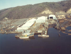
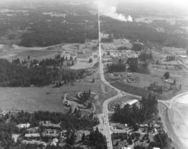
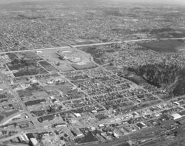
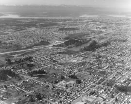
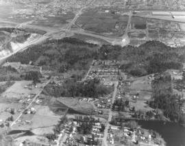
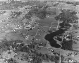
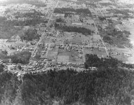
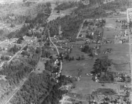
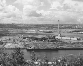
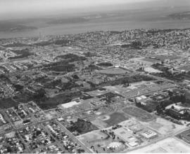
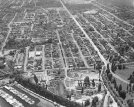
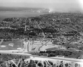
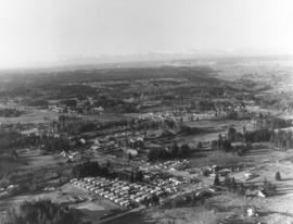
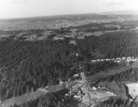
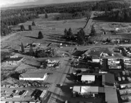
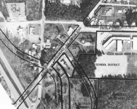
ca. 1972. Copy of customer print, ordered by law firm of Murray, Scott & McGavick on October 16, 1972. This is an aerial of the Gig Harbor area with various streets and company names written in. It appears that future construction of on and off-ramps and an overpass will impact housing and businesses already present. This is in the vicinity of Wollochet Gig Harbor Road.


Aerial views; Maps;

D163000-114C

ca. 1973. 1973 Richards stock footage. Closer aerial look at shipyard on the Hylebos Waterway, believed to be Tacoma Boatbuilding who had constructed a $3,000,000 plant there after the disastrous fire of 1968 which had destroyed their Sitcum Waterway facility. The Hylebos location now provided 20 acres of space and held separate buildings for aluminum fabricating, steel fabricating, administrative and engineering, and warehouse for equipment. Several boats are pictured above docked at the 300-foot pier. TPL-6583


Aerial views; Boat & ship industry--Tacoma--1970-1980; Tacoma Boat Building Co., Inc. (Tacoma); Hylebos Waterway (Tacoma); Logs; Piers & wharves--Tacoma--1970-1980;

D163161-3

One of a series of photographs taken on behalf of Collison Realty by the Richards Studio on April 3, 1973. These aerial views focused on the 112th & Meridian neighborhood. Eventually, the South Hill Mall would be built in this area.


Aerial views; Neighborhoods--Puyallup--1970-1980;

D163162-5

The focus of this April, 1973, aerial is the Tacoma Mall Shopping Center and its environs. Located in the city's south end, the Tacoma Mall enjoyed easy access from the freeway and acres of free parking space. Customers could choose from about 100 stores, all under one climate-controlled roof. Rhodes Bros. would be the next large department store to open in the newly expanded Mall, a move that would eventually mean the closing of its flagship downtown location in late 1974. This view, looking east, also shows South Tacoma Way at the bottom. Photograph ordered by Puget Sound National Bank.


Aerial views; Neighborhoods--Tacoma--1970-1980; Tacoma Mall Shopping Center (Tacoma); Shopping centers--Tacoma--1970-1980; Express highways--Tacoma--1970-1980;

D163162-13

Northwest view from South 84th & Park Ave. This aerial look at Tacoma's south side was taken on behalf of Puget Sound National Bank on April 2, 1973. Lake in the center is Wapato Lake, bordered by South Alaska, South 72nd and Sheridan Ave. John S. Baker Junior High (now Middle School) is near bottom-center. Park Ave. has been marked in ink. Yakima Ave. is parallel to Park and is left of Park.


Aerial views; Neighborhoods--Tacoma--1970-1980; Wapato Lake (Tacoma); Baker Junior High School (Tacoma);

D163000-105C

ca. 1973. 1973 Richards stock footage. This may be the 712-foot long tanker, "Achilles," as seen by air, docked at the Port of Tacoma in 1973. She appears to be ready to take on grain from the port's grain elevator. Other unidentified vessels are in the background.


Aerial views; Vessels; Piers & wharves--Tacoma--1970-1980;

D164908-1C

Aerial of Kaiser Aluminum plant as viewed on June 10, 1974. Smoke drifts from the 500-foot stack near the aluminum rod mill. 32 years later in July of 2006, the smokestack was demolished in front of hundreds of fascinated spectators. Color photograph ordered by Kaiser Aluminum.


Aerial photographs; Kaiser Aluminum & Chemical Corp. (Tacoma); Industrial facilities--Tacoma--1970-1980; Aluminum industry--Tacoma--1970-1980;

D164600-101

1974 Richards stock footage. Aerial view of the Tacoma Mall and surrounding south end neighborhoods. This May, 1974, view by air makes it plain that one of the main attributes of this popular shopping center was its ready access by freeway and its enormous free parking lots. Should a visitor to the Mall decide to bypass the freeway, the Mall would still be accessible through well traveled local streets such as Pine, South 38th and South 48th. The Mall had opened its west end addition in July of 1973 to add 20 more stores to the shopping center; in May of 1974, construction was proceeding rapidly with the new Liberty House/Rhodes department store at the far west end of the shopping center. TPL-5876


Aerial views; Aerial photographs; Tacoma Mall Shopping Center (Tacoma); Shopping centers--Tacoma--1970-1980; Express highways--Tacoma--1970-1980; Neighborhoods--Tacoma--1970-1980;

D165802-12

A series of aerial photographs were taken on March 27, 1975, on behalf of Puget Sound National Bank of the area between 320th in Federal Way, North Puyallup, Pacific Highway South and Valley Ave. The purpose for the photographs was not expressed in Richard studio notes but it is possible that the bank was preparing for the later acquisition of banks in the vicinity.


Aerial views;

D165802-5

A series of photographs were taken on March 27, 1975, on behalf of Puget Sound National Bank of the area between 320th in Federal Way, North Puyallup, Pacific Highway and Valley Ave. These aerial views of thirty years past show relatively undeveloped areas with little traffic.


Aerial views;

D165802-48

Aerial view, taken in March of 1975, of communities interspersed among large sections of firs. According to Richard Studio notes, the firm had been requested to take a series of photographs of the region between 320th in Federal Way, North Puyallup, Pacific Highway South and Valley Ave. for Puget Sound National Bank.


Aerial views; Firs;

D165802-6

Aerial view of heavily wooded lands possibly in the North Puyallup/Valley Ave location. This view has undoubtedly changed in the 32 years since the photograph was taken on behalf of Puget Sound National Bank.


Aerial views; Firs;

D165187-1

ca. 1974. This view of the Kaiser Aluminum plant is a cropped version of D165187, image A. It was taken circa 1974 with the focus on the 500-foot stack near right center. The stack was built in 1968, the same year Kaiser's new aluminum rod mill commenced operation.


Aerial views; Kaiser Aluminum & Chemical Corp. (Tacoma); Industrial facilities--Tacoma--1970-1980; Aluminum industry--Tacoma--1970-1980; Smokestacks--Tacoma;

D165044-2

Aerial view of Tacoma's west end neighborhoods on August 28, 1974. Main streets shown above are Pearl (running toward Point Defiance) and Sixth Avenue (more diagonally). Hunt Junior High School (now Middle) with its mushroom-shaped cafeteria/auditorium is at the bottom of the photograph. On the left side of Sixth Ave. is the Highland Hill(s) shopping center with Ernst Hardware (white building) nearby. On the left of Pearl is the Auto View Drive-In at the center of the photograph. ASARCO's smokestack is near the top of the picture. Photograph ordered by Puget Sound National Bank.


Aerial views; Neighborhoods--Tacoma--1970-1980; Auto View Drive-In (Tacoma); Henry F. Hunt Junior High School (Tacoma); Highland Hills Shopping Center (Tacoma); Smokestacks--Tacoma;

D165044-18

Aerial view of Sixth Avenue close to Orchard St. This August 28, 1974, view by helicopter shows the enormous Kmart parking lot with room for 1000 cars. Directly across the street is the new Goodyear Service, 5131 Sixth Avenue, managed by Chuck Ackley. The First Christian Church, at Sixth & Orchard, is separated from the Goodyear store by a thick strand of firs. Smaller strip malls have since been erected on the wooded sites to the left and rear of the Goodyear store. Photograph ordered by Puget Sound National Bank.


Aerial views; Neighborhoods--Tacoma--1970-1980; Parking lots--Tacoma--1970-1980; Kmart (Tacoma); Goodyear Service (Tacoma); First Christian Church (Tacoma);

D165802-38

I-5, SR18 and Weyerhaeuser headquarters. The Richards Studio photograph took a series of photographs of the area between 320th in Federal Way, North Puyallup, Pacific Highway South and Valley Ave. on March 27, 1975, for Puget Sound National Bank. The I-5 freeway runs at the bottom of the photograph. State Route 18 is toward the top. This is also a closer view of the Weyerhaeuser Corporation's headquarters which were built in 1971 in Federal Way. Previously the company had been based in Tacoma. Weyerhaeuser would celebrate its 100th annivesary in January of 2000.


Aerial views; Weyerhaeuser Timber Co. (Federal Way); Express highways--Wash.;

D159700-246C

1971 color Richards stock footage. Aerial view of ASARCO (American Smelting & Refining Co.) in May of 1971. Two ships are docked to be loaded with metals for shipment outside Washington state. The famous ASARCO smokestack is near the right corner edge; the 571-foot giant chimney was imploded in 1993, nine years after the plant had closed. The dark gray color of the plant grounds is in stark contrast to the deep blue waters of Puget Sound; the color is due to slag.


Aerial views; American Smelting & Refining Co. (Tacoma); Smelters--Tacoma--1970-1980; Smokestacks--Tacoma;

D159700-184C

ca. 1971. 1971 color Richards stock footage. Aerial view of downtown commercial district with glimpse of industrial Tideflats. This is a look at the area around So. 12th and Pacific Avenue with the towering Bank of Washington Plaza attracting the viewer's eye. The giant circle surrounded by a spaced planting of trees is the plaza's fountain. A circular staircase leads down to the fountain and courtyard, with a restaurant and specialty shops included. Directly across the street from the fountain is the Park Plaza South parking garage. The Pacific National Bank of Washington's closest banking neighbors are Puget Sound National Bank (with spire) and Seattle-First, in left corner. The City Waterway (now Thea Foss Waterway) is in the background with the railroad bridge and the 15th St. Bridge connecting the city with the industrial Tideflats area.


Aerial views; Pacific National Bank of Washington (Tacoma); Puget Sound National Bank (Tacoma); Seattle-First National Bank (Tacoma); Banks--Tacoma; Parking garages--Tacoma--1970-1980; City Waterway (Tacoma); Business districts--Tacoma--1970-1980;

D159700-241C

ca. 1971. 1971 color Richards stock footage. Aerial view of tree-filled Wright Park, Tacoma General Hospital (in center) and Commencement Bay, taken on a clear day in 1971. Park grounds are carefully manicured and pathways clearly marked. Dedicated in 1886, Wright Park provided a peaceful alternative to busy city life.


Aerial views; Wright Park (Tacoma); Parks--Tacoma--1970-1980; Tacoma General Hospital (Tacoma); Commencement Bay (Wash.);

D160364-24

Aerial view of Franke Tobey Jones retirement home and surrounding acreage as seen by air in June of 1971. The Tudor-styled home, established in 1925 as a non-profit retirement community, is next door to Point Defiance. Due to the generosity of Mrs. Jones, whose husband was a co-founder of a major lumber concern in Tacoma, the retirement home was able to be built for $150,000. She had donated the money and also the four acres of land on which the building would stand. By 2006, the Franke Tobey Jones campus had expanded to 20 acres and included the new Garden Apartments and M.J. Wicks Family Wellness Center. Photograph ordered by Puget Sound National Bank. (www.franketobeyjones.com)


Aerial views; Franke Tobey Jones Home (Tacoma);

D160364-27

This is an aerial view in June of 1971 of the Point Defiance neighborhood. The Tacoma Yacht Club and marina are on the left corner edge. The curved track in lower center is believed to be used for go-karting. Pearl Street is the lightened long line running vertically into Point Defiance Park, a portion of which can be seen to the lower right. Road near bottom leads to the ferry dock. Photograph ordered by Puget Sound National Bank.


Aerial views; Neighborhoods--Tacoma--1970-1980; Tacoma Yacht Club (Tacoma); Point Defiance Park (Tacoma);

D160364-19

Vassault Park neighborhood in 1971. In the distance can be seen the Tacoma Tideflats with smoke stacks in full operation. Vassault Park is on the left; it lies between Vassault St. at the bottom and Pearl St. The North End tower and reservoir are center-right. No. 30th St. runs on the right of the reservoir. Photograph ordered by Puget Sound National Bank.


Aerial views; Neighborhoods--Tacoma--1970-1980; Vassault Park (Tacoma); Reservoirs--Tacoma; Water towers--Tacoma;

D160622-3

Closer view by air of various Tacoma waterways in the Tideflats. The Puyallup, St. Paul and Middle Waterways are photographed on June 25, 1971, along with assorted log dumps, oil and chemical tanks, and the bustling St. Regis Paper Co. plant, one of the region's largest employers. Photograph ordered by Foss Tug & Barge.


Aerial views; Puyallup Waterway (Tacoma); St. Paul Waterway (Tacoma); Middle Waterway (Tacoma); St. Regis Paper Co. (Tacoma)--1970-1980;

D160622-5

Snow capped Mount Rainier glows dimly in the background on this somewhat cloudy and/or foggy day in June of 1971. In the foreground are a portion of the Puyallup Waterway, St. Paul Waterway and Middle Waterway. On the left edge is St. Regis Paper Co. Barges floating near the mouth of the Middle Waterway are laden with chips and other materials. There are several log dumps visible. Photograph ordered by Foss Tug & Barge.


Aerial views; Rainier, Mount (Wash.); Puyallup Waterway (Tacoma); St. Paul Waterway (Tacoma); Middle Waterway (Tacoma); St. Regis Paper Co. (Tacoma)--1970-1980; Barges--Tacoma;

D161273-11

A Richards Studio photographer flew over the vicinity of 112th & Meridian on a clear January day in 1972 to take a series of photographs of this Puyallup-area neighborhood. Photograph ordered by Puget Sound National Bank.


Aerial views; Neighborhoods--Puyallup--1970-1980;

D161273-18

A look by air at the 112th & Meridian South neighborhood in Puyallup in the early part of January, 1972. On the left appears to be a trailer court. Photograph ordered by Puget Sound National Bank.


Aerial views; Neighborhoods--Puyallup--1970-1980;

D161273-9

Wooded terrain in the neighborhood of 112th & Meridian. This view was taken by air on January 2, 1972, on behalf of Puget Sound National Bank.


Aerial views; Neighborhoods--Puyallup--1970-1980;

D161273-8

Aerial view in January of 1972 of "Willows Corner," about 112th & Meridian St. Building labeled "Flea Mart," on the right side, was the former Willows Tavern/The Willows. Builder J.J. Mabbott was responsible for the "pavilion" built near Puyallup in 1927. The area around 112th & Meridian would be greatly developed in the future, with the South Hill Mall being constructed in 1988. Photograph ordered by Puget Sound National Bank.


Aerial views; Neighborhoods--Puyallup--1970-1980; Willows (Puyallup);

D166700-92C

1976 Richards color stock footage. This is believed to be the St. Regis Paper Co. facility as seen by air on October 4, 1976. Massive clouds of smoke and steam emerging from the plant will soon be dispersed by the wind. This view shows several of the city's waterways and a portion of downtown Tacoma. The placid waters of the Puyallup, St. Paul, Middle and City (now Thea Foss) Waterways and the 11th St. Bridge (now Murray Morgan Bridge) are on view.


Aerial views; Aerial photographs; St. Regis Paper Co. (Tacoma)--1970-1980; Industrial facilities--Tacoma--1970-1980; Smoke--Tacoma; Puyallup Waterway (Tacoma); St. Paul Waterway (Tacoma); Middle Waterway (Tacoma); City Waterway (Tacoma);

D166000-197C

ca. 1975. 1975 Richards color stock footage. Encroaching shadows seek to wrap themselves around the landmark Union Station located at 1717 Pacific Avenue. In 1975 the station still served as an Amtrak passenger terminal. Efforts were made to restore the station to its former glory with the proposed $14,000,000 "Depot Galleria" shopping/transportation complex; however, these plans were stalled. Also visible in this aerial view is the multi-storied Albers Mill, located to the rear of the station at 1821 Dock St. TPL-7982


Aerial views; Aerial photographs; Union Station (Tacoma); Railroad stations--Tacoma--1970-1980; Albers Bros. Milling Co. (Tacoma);

Results 1 to 30 of 824