Showing 824 results

Collections
Aerial Photography Image With digital objects
Print preview View:

D11649-10

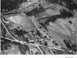
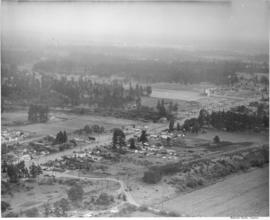
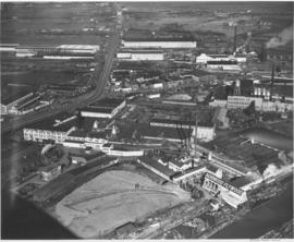
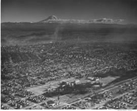
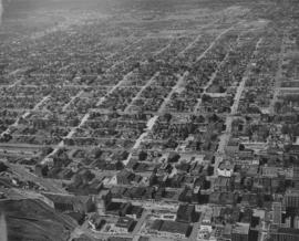
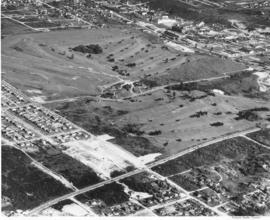
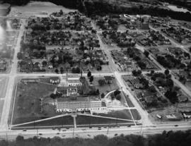
This aerial view of the Pierce County Hospital and its surrounding neighborhood was taken in July of 1941. The hospital's new north wing and new west wing were nearing completion. An extra three-mil tax levy was passed in March of 1940 to fund the expansion of the hospital. At the upper left corner is the excavation for the Lincoln Bowl, which was not completed until after WWII. Pierce County took over ownership of the hospital in 2000. (T.Times 7/31/1941 p.5)


Aerial photographs; Pierce County Hospital (Tacoma); Neighborhoods--Tacoma--1940-1950;

D11649-13

Aerial view of industrial section of Tacoma taken on July 20, 1941. The business district of downtown Tacoma is in the distance. Various log dumps dot the waterways in the foreground.


Aerial views; Aerial photographs; Cityscapes; Logs; Waterways;

D22228-14

This aerial photograph from May of 1946 shows The Narrows and the northwest side of Tacoma north of Sixth Avenue and the entrance to the Narrows Bridge. The wide road at the left is Jackson Avenue, and the large, cleared area of land in the center is "Edward P. Miller's 40 Million Dollar Country Club Estates, Tacoma's Exclusive Residential Development." The roads that cut diagonally across the development (right, bottom to left, top)are now James Street, Narrows Drive, and Fremont. TPL-3810


Aerial photographs; Aerial views; Housing developments--Tacoma--1940-1950; Land subdivision--Tacoma; Clearing of land--Tacoma;

A60069-3

Aerial photographs of the Holroyd plant were taken in July, 1951. The Holroyd Company was located at 5047 South Washington; they specialized in making concrete masonry units but also manufactured different types of building materials. They also dealt with sand and gravel and steel windows, according to an entry in the 1951 City Directory. Large lake pictured may have been used for manufacturing purposes.


Aerial photographs; Holroyd Co. (Tacoma); Concrete products industry--Tacoma--1950-1960; Building materials industry--Tacoma--1950-1960; Concrete--Tacoma;

A60067-1

In July of 1951 a massive addition to the Lakewood Community Center at 6100 Motor Avenue S.W. in Lakewood was under construction. The original center, built by Norton Clapp, opened in July of 1937. With the addition, several new stores were added to the center including Selden's Lakewood. The Lakewood Community Center was one of the country's first one-stop shopping centers. Photograph commissioned by St. Paul & Tacoma Lumber Co. TPL-4412


Aerial photographs; Lakewood Community Center (Lakewood); Progress photographs; Shopping centers--Lakewood--1950-1960;

D61250-3

Aerial view of sewage disposal plant. Hoagland and Findlay. Sewage treatment plan under construction. Wide canal on left.

D67903-4

ca. 1952. Aerial photograph of residential area, most probably Mountlake Terrace, circa 1952. Mountlake Terrace was an expanding area north of Seattle, in Snohomish County, just north of the King county line. The largely residential area served as a bedroom community for Seattle workers. The area surrounding is still heavily forested and undeveloped. The streets are laid out in curves, forming cul de sacs.


Aerial photographs; Housing developments--Mountlake Terrace;

A58591-5

Ariel photograph ordered by Tacoma Powdered Metals at 1501 East Taylor Way, Les Toulouse. A railroad spur has been added along the side of the building with loading docks available. A sign on the building announces Purex-trend.


Aerial photographs; Industry--Tacoma--1950-1960; Railroad sidings--Tacoma; Chemical industry--Tacoma--1950-1960; Purex Corp. (Tacoma);

A59833-1

An aerial view of the new pre-fab plant of Bethlehem Pacific Coast Steel Corporation along a waterway at 8501 East Marginal Way, Seattle.The Seattle Fabricating Works of Bethlehem Pacific was the newest plant in the nation capable of fabricating steel for large buildings, bridges and towers. It was built in 1950 on 8 acres of land on East Marginal Way, across from Boeing Field. It normally had about 250 employees. In the plant, structural steel and plates are cut, punched, drilled, bent, machined and prepared for erection.


Bethlehem Pacific Coast Steel Corp. (Seattle); Aerial photographs; Factories--Seattle;

D36257-5

This aerial view of the Port Industrial Waterway shows the Port of Tacoma facilities north of 11th Street as they appeared in 1948. At the far north end is the Port's grain elevator with a capacity of 2-million bushels. Log booms can be seen in both the Sitcum Waterway, on the left, and in the Port Industrial Waterway, bottom right. The U.S. Naval Station is at the upper right with a flotilla of over 15 moth-balled baby flat top aircraft carriers at dock. TPL-3684


Aerial photographs; Bays--Washington (State); Commencement Bay (Wash.); Port of Tacoma (Tacoma)--1940-1950; United States Naval Station (Tacoma); Logs;

D34647-3

Aerial view of South Tacoma Way and the surrounding community. South Tacoma has been expanding rapidly since the end of World War II with growth in the industrial, business and residential areas. View of neighborhoods and the Star-Lite Park In Theatre located along South Tacoma Way as taken in August of 1948. (T. Times, 8/31/48, p. 21) TPL-9090


Cities & towns--Tacoma; City & town life--Tacoma; Aerial views; Aerial photographs; Neighborhoods--Tacoma; Drive-in theaters--Tacoma; Star-Lite Park In Theatre (Tacoma); South Tacoma Way (Tacoma); Streets--Tacoma--1940-1950;

D35933-1

Port of Tacoma aerials. A view of St. Regis and the nearly completed kraft paper plant seen in the foreground. The company is located along the Puyallup Waterway on the Tacoma tideflats.


Aerial photographs; Progress photographs; St. Regis Paper Co. (Tacoma)--1940-1950; Paper industry--Tacoma--1940-1950;

D35933-13

Aerial photographs. Shaffer Terminals had two locations, one along the Tacoma waterfront at the foot of Division Avenue and the other on the Tacoma tideflats along the Milwaukee Waterway. This view shows ships tied along the facilities at Milwaukee Waterway and Chicago, Milwaukee and St. Paul Railway Terminal is across the waterway.


Aerial photographs; Shaffer Terminals, Inc. (Tacoma); Marine terminals--Tacoma;

D35933-27

Aerial photographs. A view of Tacoma from the industrial tideflats. The ASARCO stack is in the background. In the immediate foreground is the St. Paul & Tacoma Lumber Company with its many buildings, stacks and scrap burner. East 11th Street comes in from the left and runs across to the right. St. Paul Avenue starts at East 11th Street and takes off to the bottom left corner. The St. Paul & Tacoma Lumber Company is sprawled on both sides of East 11th Street and they had a dock at the end of the land between Middle Waterway and St. Paul Waterway (center,far right). City Waterway is next to Tacoma


Aerial photographs; St. Paul & Tacoma Lumber Co. (Tacoma); Cityscapes; Lumber industry--Tacoma--1940-1950; Smokestacks--Tacoma;

D35471-1

An aerial view looking east across the Tacoma tideflats with St. Regis Paper Company in the foreground. St. Regis was nearing completion of a $6 million addition to their kraft paper plant and adding a multi-wall bag plant. They have been at this location on the tideflats since 1936.


Aerial photographs; St. Regis Paper Co. (Tacoma)--1940-1950; Progress photographs; Paper industry--Tacoma--1940-1950; Lumber industry--Tacoma--1940-1950; Industrial facilities--Tacoma--1940-1950;

D35790-10

Aerial views: Port Piers, Washington Co-op, grain storage tanks at Port of Tacoma, Norwood Plywood, City Center. Studio, Bob. An aerial of the Washington Cooperative Farmers Association grain elevator and feed mill located at 1801 Taylor Way. The facility was to officially open March 1949. In the foreground are the boat building facilities the J.M. King Company at 1601 Taylor Way. Buffelin Lumber is seen on the other side of the co-op. The Hylebos Waterway crosses the upper left corner with log booms along both sides.


Aerial views; Industrial facilities--Tacoma--1940-1950; Grain elevators--Tacoma; Logs; Washington Cooperative Farmers Association (Tacoma); Buffelen Lumber & Manufacturing Co. (Tacoma); John M. King Co. (Tacoma); Hylebos Waterway (Tacoma);

D35790-7

Aerial views: Port Piers, Washington Co-op, grain storage tanks at Port of Tacoma, Norwood Plywood, City Center. Studio, Bob. An aerial view of the Tacoma tideflats looking east. East 11th Street comes from the left and curves northeast across the St. Paul Waterway. St. Paul Avenue starts at East 11th Street and moves southeast towards the Puyallup River. The Wheeler-Osgood Company (at 1216 St. Paul Avenue) is seen in the center, right section. Northwest Door (1203 East D Street) is at the corner of East 11th and East D (center left). Norwood Plywood is believed to be the plywood facility for Northwest Door who began their plywood operations in 1936. The spider-like pipes running from a central location to several buildings is part of Wheeler-Osgood. The corner lot (center front) has been vacant since at least 1938.


Aerial views; Industrial facilities--Tacoma--1940-1950; Wheeler, Osgood Co. (Tacoma); Northwest Door Co., Inc. (Tacoma);

D31634-8

Aerial view of Tacoma, tide flats, CPS, City downtown area. This elevated view shows the Tacoma tideflats and the waterways that run and were cut through it, the Puyallup Valley and Mount Rainier in the background. Log booms are strung together in the forefront, near St. Regis paper mill. The Port of Tacoma had been working with reclaimation of the tidelands, construction of deep waterways and lease or sale of suitable sites for new factories for nearly 30 years since Tacoma voters approved a plan of development under an elective commission. During the decade of the 1940's an extended program had been developed which was to ensure hundreds of acres of new sites and provision for more deep water frontage for those to whom ocean commerce was vital. Mount Rainier is seen in the background. (T.Times, 1/12/1948, p.5)


Aerial photographs; Harbors--Tacoma--1940-1950; Waterfronts--Tacoma; Logs; Land use--Tacoma--1940-1950; City planning--Tacoma--1940-1950; St. Regis Paper Co. (Tacoma)--1940-1950; Paper industry--Tacoma--1940-1950; Rainier, Mount (Wash.);

D31645-2

ca. 1947. An aerial photograph shows the College of Puget Sound campus in the foreground and Mount Rainier in the distance. TPL-6702


Aerial photographs; Universities & colleges--Tacoma; College of Puget Sound (Tacoma)--Buildings;

D28672-8

Aerial view on July 13, 1947 of West Coast Grocery, St. Paul and Tacoma Lumber Company and Tacoma Iron and Steel. A view of the Tacoma tideflats and some of the industry built on it looking northeast.


Tacoma Tideflats (Tacoma); Aerial photographs; Industry--Tacoma--1940-1950;

D33167-1

This aerial view of downtown Tacoma, taken in May of 1948, shows the city looking up 9th Street from the railroad tracks that line the waterfront to Tacoma Avenue. Prominent in the foreground is the parking lot located at the former location of the Tacoma Hotel, 913 A Street. The hotel occupied the site from 1884 until it was destroyed by fire in 1935. In 1988, the Frank Russell Co. built their offices at this location. Left of the parking lot on A St. were (l to r): the Tacoma Building (1017-21 A St.), the Lawrence Block (1009-15 A St.- demolished) and the Mason Block (1001-07 A St.- demolished.) The Weyerhaeuser Building (1015 A St.) now occupies the site of the demolished buildings. Also shown is the Hotel Winthrop (773 Broadway) across 9th St. from the Pantages Theater (902 Broadway). The Tacoma Theater (902-14 Broadway) can be seen behind the Pantages and the Medical Arts building (747 Market- now the Tacoma Municipal Building) can be seen beyond the Winthrop. Photograph ordered by Miss Helen Whitney. TPL-1440


Aerial photographs; Hotel Winthrop (Tacoma); Cityscapes; Railroad tracks--Tacoma; Business districts--Tacoma; Commercial streets--Tacoma--1940-1950;

D34612-24

This was how Tacoma's Stadium district appeared from the air in August of 1948. The First Presbyterian Church at 20 Tacoma Avenue South, marked by its bell tower, lay at the corner of Tacoma Avenue South and Division Avenue. The Big Bear Market (618-20 No. 1st St.) and Walker Chevrolet (633 Division) were in the narrow portion of the pie shaped wedge between Division Avenue and North 1st Street. Stadium High School, 111 No. E St., was in the upper left and the Shaffer Terminals lined Commencement Bay in the background. Photo ordered by Columbia Breweries.


Aerial photographs; Neighborhoods--Tacoma; First Presbyterian Church (Tacoma); Stadium Market (Tacoma); Stadium High School (Tacoma); Shaffer Terminals, Inc. (Tacoma);

D34815-26

The areas around South 15th and South 17th Streets were photographed by air in August of 1948. The Old St. Joseph Hospital (1812 S. "I") is on the left center side of the picture. The ballpark at the upper right hand corner is believed to be Athletic Park (later renamed Peck Field), 1418 S. Sprague.


Aerial views; Aerial photographs; Streets--Tacoma--1940-1950; Neighborhoods--Tacoma--1940-1950; St. Joseph's Hospital & School of Nursing (Tacoma);

D34612-13

This is an aerial view of the Prospect Hill neighborhood which was taken in August of 1948. The photograph mainly focuses on the intersection of East Road and North Road. The large and elegant homes included 91 East Road, 95 East Road (since demolished) and 101 East Road to the left . There is a vacant lot on the right side of East Road and another spacious residence at 102 East Road.


Aerial views; Neighborhoods--Tacoma--1940-1950;

D25712-2

This aerial view of the west side of Tacoma, taken in February, 1947, shows the area north of South 19th and west of Jackson Avenue just north of University Place. Streets have been graded for the future development of Narrowmoor, a residential community of custom built, single-family homes. In 1960, a report by the City of Tacoma stated that Narrowmoor covers an area of 11 blocks by 6 blocks and ranked as "the largest subdivision of quality housing in the city"; all building sites have an excellent view of the Narrows; lots are selling for $5,000 to $8,000; and, homes range in value from $25,000 to $100,000. In 1947 there was no bridge across the narrows. (Report by the City of Tacoma to the Japan Housing and Community Development Team, Tacoma, Washington, August, 1960). TPL-919


Aerial views; Aerial photographs; Land use--Tacoma;

D25712-8

Aerial view of Hooker Chemicals Plant on the tideflats. A recent merger brought Hooker Electrochemical Company of Tacoma and Niagara Falls, New York and the Detrex Corporation of Detroit, Michigan together, bringing a new company in the chemical industry to Tacoma. The Hooker-Dextrex plant can be seen towards the the top of the image (north), just lower left of the ship yard's water tower. Hooker companies were spread throughout 47 acres in Tacoma (T. Times, 2/26/1947 3B).


Aerial views; Aerial photographs; Waterfronts--Tacoma; Industrial facilities--Tacoma; Hooker Detrex, Inc. (Tacoma); Hooker Electrochemical Co. (Tacoma);

D25712-3

Studio aerial views for Tacoma Times 18 page Business and Industrial Review. Tacoma industries were growing and expanding, gaining national and international recognition. Tacoma was a leader in many industries including: boat and ship building, machinery development, lumber and plywood, chemical plants, grocery wholesalers and flour mills (T. Times, 2/26/1947, Sec. B).


Aerial views; Aerial photographs; Waterfronts--Tacoma; Land use--Tacoma; Industrialization--Tacoma;

A49811-2

Aerial view of Allenmore Golf Course. The club house is seen in the middle of the large, newly landscaped golf course. The fairways are seen switch back style through the foreground and far background. New housing sub-divisions are seen across So. 19th Street.


Allenmore Golf Club (Tacoma); Golf--Tacoma--1950-1960; Sports & recreation facilities--Tacoma; Aerial photographs; Land use--Tacoma;

A41825-3

Pennsylvania Salt manufactured the following chemicals: chlorine, caustic soda, sodium hypochlorite, bleaching powder, hydrogen, sodium arsenate, dairy and poultry germicides, special chemical cleaners and laundry and dry cleaning products. Frederick C. Shanaman was the President and General Manager of the company. Aerial view of the Tacoma plant, located at 2901 Taylor Way, in Tacoma's tideflats, near the Turning Basin, which is now known as the Hylebos Basin.


Chemical industry--Tacoma--1940-1950; Chemicals; Industrial facilities--Tacoma; Aerial photographs; Aerial views; Waterfronts; Pennsylvania Salt Manufacturing Co. of Washington (Tacoma);

D43866-15

Studio stock negatives. An aerial photograph of a rural area with a highway running across it. A woods and lake are seen on the lower half while several buildings around a cleared area are seen above.


Aerial photographs; Land;

Results 1 to 30 of 824