Showing 381 results

Collections
With digital objects 138,000-142,000
Print preview View:

A139500-189

A Brute Crane manufactured by the Star Iron & Steel Co. of Tacoma is in the process of hoisting lumber at the Seattle Export Lumber Co. There are piles of lumber on both sides of the crane. Date of original photograph is unknown; copy made on September 17, 1963.


Star Iron & Steel Co. (Tacoma); Hoisting machinery; Lumber; Seattle Export Lumber Co.;

A139670-4

Porta Tower in operation at the Cotten Bros. logging site in Packwood on October 23, 1963. Used as portable steel spur trees, "Porta Towers" were manufactured by Star Iron & Steel Co. of Tacoma for use in the logging industry. Star Iron & Steel was well known for their cranes and specialized equipment which included hydraulic presses, log barkers, radio and television towers, and chip handling buckets. Photograph ordered by Star Iron & Steel Co.


Star Iron & Steel Co. (Tacoma); Steel; Hoisting machinery; Logs;

A139205-12

Interior of new Washington Natural Gas Co. headquarters in the late summer of 1963. The spacious floor space has plenty of room for new household appliances utilizing natural gas - stoves, washers and dryers, hot water heaters and refrigerators. Wall-to-ceiling folding doors can be used to separate portions of the buildings including a meeting/demonstration area. Photograph ordered by Bozell & Jacobs Advertising.


Washington Natural Gas Co. (Tacoma); Merchandise displays--Tacoma--1960-1970; Appliances;

A139205-14

Head-on shot of interior of the new Washington Natural Gas Co. building on So. 38th St. near Union shows the length of the structure; there are no formal walls in place to shorten the view. The height of the building is emphasized by its tall ceilings and windows near the roofline. Customer service desks are tucked along side of the expansive windows near the wall-to-ceiling folding doors. Customers could easily view the natural gas appliances on display with plenty of room to stroll and compare. Photograph ordered by Bozell & Jacobs Advertising. (TNT 9-10-63, B-1)


Washington Natural Gas Co. (Tacoma); Merchandise displays--Tacoma--1960-1970; Appliances;

A139205-18

Part of the main floor of the new Washington Natural Gas Co. headquarters was used for demonstrations/training sessions. Several rows of chairs are pictured on August 27, 1963, towards the rear of the building in the "Blue Flame" auditorium. Up to 80 people could be accommodated in this meeting area. The new Washington Natural Gas Co. structure was built of pre-cast concrete by the Nelson Construction Co. It was located on the site of the old Tiger Field/Cheney Field on So. 38th St. near Union Avenue. Photograph ordered by Bozell & Jacobs Advertising. (TNT 9-10-63, B-6)


Washington Natural Gas Co. (Tacoma); Public utility companies--Tacoma; Folding chairs;

C139793-4

ca. 1870. On October 9, 1963, the Pierce County Pioneer & Historical Association dedicated a marker on the site of the old Steilacoom jail. The marker was made of imported red Swedish granite on which was carved a view of the (pictured) two-story jailhouse. The jail was built in 1858 by George W. Manville, Spanaway architect and contractor. It was the first brick jail north of the Columbia, the first Pierce County jail, and the first jail in the Washington Territory. It was located at 1800 Starling Street, between Balch & Main. Moses Spicer, elected in 1859, was the first jailer. It served as a jail until 1881 and then was used to store government records. In 1910 Dr. S.M. LaCrone and his wife purchased the old jail; the LaCrones lived on the top floor. The jail was demolished in 1944. (TNT 10-6-63, A-1)


Jails--Steilacoom;

C139793-5

ca. 1895. View of Steilacoom Transfer Co. stable and horses taken ca. 1895; it was located at the corner of Wilkes & Commercial. Building to the right may be the home of the Steilacoom Transfer Co. owner and operator, Nick Doering. The firm, a livery, feed and fuel company, was one of Steilacoom's oldest businesses. Wagons and horses could be rented at Doering's establishment as well as purchase of the food necessary to feed the animals. Wood and bark could also be bought and delivered to customers. Proprietor Nick Doering had been born in Germany and came to the United States as a youngster, working and residing in Wisconsin and South Dakota. He came to Steilacoom and began a successful hauling and transfer business. His horses would not only haul deliveries as far away as from Tacoma but would also plow and later haul sand and gravel for the new Northern Pacific railway roadbed. The family business thrived and was maintained even after Doering's death in 1942. His son and grandson continued the business until it was sold to Lakewood Fuel Co. in 1971. (Town on the Sound, p. 99, Steilacoom Historical Museum Quarterly, Fall 1986, p. 1)


Steilacoom Transfer Co. (Steilacoom); Carts & wagons--Steilacoom; Horses--Steilacoom; Doering, Nick--Associated objects;

D140600-258

This was how the Cliff House Restaurant on Browns Point, center front, appeared from the air on June 23, 1964. Perched on a hillside overlooking Tacoma's waterfront, the Cliff House Restauant provided its customers with fine cuisine and scenic views. Originally built as a tavern in 1925, it was later remodeled and rebuilt after a massive fire in 1958. Houston "Hugh" O. Smith was still the owner in 1964.


Aerial photographs; Aerial views; Cliff House Restaurant (Tacoma); Restaurants--Tacoma--1960-1970; Neighborhoods--Tacoma--1960-1970;

D140600-25

Aerial photographs of So. 38th & Pine & freeway taken in February, 1964; stock footage. So. 38th St. cloverleaf upper left; I-5 runs across top portion of photograph. This focuses on the location of the upcoming Tacoma Mall Shopping Center. The Bon Marche, the first store built at the Mall, is the massive building standing alone in large otherwise vacant lot. The wooded area near the Bon would change soon as the Mall expanded; the National Bank of Washington and J.C.Penney had already announced plans to build in the Mall area and other stores would later join them. The circular building in the center is part of Madison School.


Aerial photographs; Bon Marche (Tacoma); Express highways--Tacoma--1960-1970; Shopping centers--Tacoma--1960-1970;

D140600-407

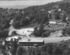
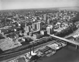
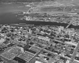
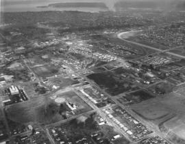
Stock footage, 1964. Aerial view of downtown Tacoma business district looking toward Point Defiance, taken on September 30, 1964. The ASARCO smelter can barely be seen in the distance. Closer focus is on portions of A St., Pacific Ave., and Tacoma Ave. So. with its multitude of tall buildings. Tacoma Building and Perkins Building flank the 11th Street Bridge which crosses the City (now Thea Foss) Waterway. Puget Sound National Bank, Washington Building, Rust Building, Peoples store, are closer to the waterway with the County-City Building, Tacoma Public Library and Central School on Tacoma Ave. So., several blocks away.


Aerial photographs; Commercial streets--Tacoma--1960-1970; 11th Street Bridge (Tacoma); City Waterway (Tacoma); Perkins Building (Tacoma); Tacoma Building (Tacoma); Washington Building (Tacoma); Rust Building (Tacoma); County-City Building (Tacoma);

D140600-236

1964 stock footage. Downtown business district and industrial Tideflats area are captured in this June 23, 1964, aerial photograph. 11th Street Bridge crosses the City (now Thea Foss) Waterway into the bustling Tideflats. Smoke can be seen rising from St. Regis Paper Co. whose operations ran 24 hours a day. Prominent structures in the downtown area included the Tacoma Bldg., Perkins Bldg., Puget Sound National Bank, Washington Bldg., Rust Bldg., Medical Arts Bldg., and further to the lower portion of the photograph, the County-City Building and Tacoma Public Library. State Armory is also located at bottom's edge.


Aerial photographs; Commercial streets--Tacoma--1960-1970; County-City Building (Tacoma); Tacoma Public Library (Tacoma); 11th Street Bridge (Tacoma); City Waterway (Tacoma); St. Regis Paper Co. (Tacoma)--1960-1970; State Armory (Tacoma);

D140600-40

This aerial view of the channelized Puyallup River as it flows through the Tacoma tideflats dates from February of 1964; the East 21st Street Bridge is at the bottom, center. Nearer to the mouth of the River, in the left corner, are the East 11th Street Bridge and the old Milwaukee Road railroad bridge. There is little development between East 11th Street and Lincoln Avenue. The buildings in the Port of Tacoma can be seen in the distance and Northeast Tacoma is on the horizon.


Aerial photographs; East 21st Street Bridge (Tacoma); Bridges--Tacoma;

D140189-5

Aerial view of Gov-Mart South building between Hwy. 99 and I-5 on December 10, 1963. Gov-Mart South was a discount department store. In the upper left can be spotted Clover Park Vocational School. In the upper right corner beyond the trees is the Southgate housing development. Photograph ordered by Puget Sound National Bank.


Aerial photographs; Gov-Mart South (Lakewood); Department stores--Lakewood--1960-1970; Express highways--Lakewood;

D140189-12

Aerial view looking south on Hwy 99 (South Tacoma Way) taken on December 10, 1963. McChord Field can faintly be seen in the background. Spanaway Lake is believed to be in the upper left corner area. Clover Park Vocational to the far right. Star-Lite drive-in left center. Photograph ordered by Puget Sound National Bank. TPL-9303


Aerial photographs; Neighborhoods--Tacoma--1960-1970;

D140189-10

Aerial view of South Tacoma Way and vicinity on December 10, 1963. Star-Lite drive-in theater is believed to be towards upper right center. Port of Tacoma in the distance, upper right corner. Photograph ordered by Puget Sound National Bank.


Aerial photographs; Neighborhoods--Tacoma--1960-1970; Commercial streets--Tacoma--1960-1970;

D140600-28

The So. 38th St. & Pine area would see tremendous growth in traffic and commerce with the coming of the Tacoma Mall in the mid-1960's. I-5 would allow easy access to the shopping center. This area view taken in February, 1964, shows So. 38th St., portion of I-5, Lincoln Heights neighborhood and to the center right, the soon-to-be-built Tacoma Mall. The Bon Marche, not visible in this photograph, was the first store built in the Mall; it was located in the large lot in the right corner. The round building on So. 43rd near Pine is part of Madison School.


Aerial photographs; Shopping centers--Tacoma--1960-1970; Neighborhoods--Tacoma--1960-1970; Express highways--Tacoma--1960-1970;

D140600-237

1964 stock footage. New construction at St. Regis Paper Co. St. Regis saw a major expansion and modernization project go into effect in 1964 with the building of a new stud mill, veneer mill, and new 15-acre dry-land log-handling yard. 35 acres of new land were created on the harbor for the new facilities when a saltwater log pond was filled in. Two giant stackers would classify and handle the logs received by truck, rail and water, accumulating an inventory in preparation for the stud and veneer mills. Both mills were expected to be in operation by April, 1965. (1964 St. Regis Annual Report, p. 20)


Aerial photographs; St. Regis Paper Co. (Tacoma)--1960-1970; Building construction--Tacoma--1960-1970;

D140600-240

Stock footage of So. 19th & Union Ave. in Tacoma's northend. This June 23, 1964, aerial view shows the newly built Unionaire Apartments, 1902 So. Union Ave. The 46-unit complex was built by Lundstrom Bldg. Enterprises; units had Marblecrete exterior. The Allenmore Medical Center would be built the following year across the street from the Unionaire at 1901 So. Union.


Aerial photographs; Unionaire Apartments (Tacoma);

D140588-47C

In January 1964 Puyallup native Dave Bunker was photographed while holding his patented Duo-Lectar, double neck electric guitar. He and his father made the first Duo-Lectar in 1955; lacking money, they made the frets out of an old chain saw blade. The necks on the guitar are of differing sizes but can be played at the same time by touching or tapping. Mr. Bunker went on to become a well known guitar builder and luthier; he performed for many years in Las Vegas and for military audiences around the world. (www.bunker-guitars.com) TPL-8784


Bunker, Dave; Musicians; Guitars;

D140041-3

Elevated view, using a Puget Sound Power & Light truck, of the Cavalier Apartments complex on December 11, 1963. Eight 4-plexes composed the Colonial style Cavalier Apartments which were located at 11th & Stewart in Puyallup. An landscaped oval in the center of the complex contained a large heated swimming pool. Owner David Hunt indicated that the Cavalier was built with the concept of no stairs for easy maneuverability and no laundry rooms; each unit had a washer/dryer. A large ad in the March 1, 1964, News Tribune specifically welcomed children to the Cavalier. The design using 4plexes and the large 2 1/2 acreage, would lessen any noise produced by small ones. Photograph ordered by Briggs Manufacturing. (TNT 3-1-64, B-5)


Cavalier Apartments (Puyallup); Housing developments--Puyallup; Swimming pools--Puyallup;

D140588-20C

Patty and Vicki Wilkinson are barefoot and crouching with guitars in hand in an unusual January 10, 1964, photograph. They may have been part of the Dave Bunker Quintet. Identification provided by patron.


Guitars;

Results 361 to 381 of 381