Showing 57 results

Collections
Aerial Photography With digital objects 148,000-152,000
Print preview View:

D150900-358

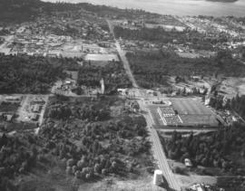
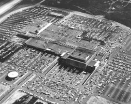
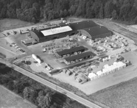
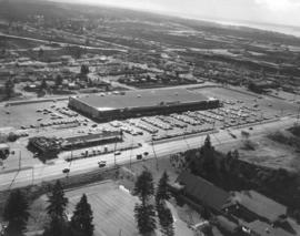
1967 Richards stock file. Aerial view of new Kmart department store, 5132 Sixth Ave., with nearly full parking lot, taken on October 28, 1967. Kmart was located next to Busch's Sixth Ave. Drive-in and across the street from the First Christian Church. G. Kirkebo & Sons were general contractors; architect was E.D. McCarthy of Spokane. The 105,000 square foot building was situated on a 10.5 acre site with parking for 1000 cars. (TNT 1-23-67, p. 7)


Aerial photographs; Kmart (Tacoma); Department stores--Tacoma--1960-1970; First Christian Church (Tacoma); Busch's Sixth Avenue Drive-In Restaurant (Tacoma);

D150900-352

1967 Richards stock file. Aerial photographs of the University Place neighborhoods surrounding 40th & Bridgeport Way were taken on October 28, 1967. This area was still heavily wooded. Building complex on the right side of photograph is the University Village Shopping Center which was scheduled to open in October, 1967. Food King supermarket and Don's Village Drugs would be major clients of the shopping center. At the bottom of the photograph is the University Place water tower which had been remodeled in 1964 to hold 400,000 gallons.


Aerial photographs; Neighborhoods--University Place; Shopping centers--University Place; Food King (University Place); Water towers--University Place;

D150900-367

1967 Richards stock footage. Aerial view of Port of Tacoma's Pier 7 in the Tacoma Tideflats. Dome is the 242-feet in diameter Kaiser Dome which stored alumina ore. Alumina moving out the dome could be loaded directly into railroad hopper cars. The three main means of transporting Tacoma's industrial products, rail, water and highways, converge in this October 28, 1967, photograph. (TNT 6-23-67, p. 7)


Aerial photographs; Storage tanks--Tacoma; Logs; Railroad freight cars--Tacoma--1960-1970; Cargo ships--Tacoma--1960-1970; Piers & wharves--Tacoma--1960-1970;

D150900-231

1967 Richards stock file. Another aerial view of the Tidewater Oil Co. facilities on East D St. in the tideflats taken on June 15, 1967. The plant was located next to Puget Sound Plywood Co. whose rooftop sign can be readily seen. The plywood company's log dumps appear to be encrouching onto Tidewater Oil premises. Tidewater had large piers which made transport and transfer of its products onto ships an easier task.


Aerial photographs; Tidewater Oil Co. (Tacoma); Industrial facilities--Tacoma--1960-1970; Storage tanks--Tacoma; Puget Sound Plywood, Inc. (Tacoma); Logs; Piers & wharves--Tacoma--1960-1970;

D150900-111

1967 Richards stock file. Aerial view of Tacoma's waterfront taken on April 11, 1967. Familiar city landmarks are the heavily wooded Wright Park in left-center; 11th Street Bridge crossing the City (now Thea Foss) Waterway; County-City Building in lower-center; St. Regis Paper Co. plant in the Tideflats industrial area with smoke billowing from its many stacks; and the dark waters of Commencement Bay.


Aerial photographs; Waterfronts--Tacoma--1960-1970; Wright Park (Tacoma); 11th Street Bridge (Tacoma); County-City Building (Tacoma); St. Regis Paper Co. (Tacoma)--1960-1970; Smoke--Tacoma; Commencement Bay (Wash.);

D151508-1

Aerial photograph of J.M. Martinac Shipbuilding facility taken on April 11, 1967. The shipbuilding's namesake is docked nearby. The 154-foot tuna boat was the fifth tuna seiner built for Lou Brito of San Diego who had developed a close working relationship with Joe Martinac. Mr. Martinac's mother christened the ship. The J.M. Martinac was the largest seiner ever built by Martinac Shipbuilding. West Coast Grocery Co. can be seen in background. Photograph ordered by J.M. Martinac Shipbuilding. (TNT 2-19-67, B-4, TNT 3-28-67, A-1) TPL-9123


Aerial photographs; J.M. Martinac Shipbuilding Corp. (Tacoma); Boat & ship industry--Tacoma--1960-1970; Fishing boats--Tacoma--1960-1970;

D151531-2

Aerial of new Kaiser Dome, part of the Port of Tacoma's 1.6 million dollar bulk storage facility project, taken in late April, 1967. The aluminum sheathed dome will handle alumina under contract with Kaiser Aluminum. The Port expects 40,000 tons of alumina a month shipped from Australia. Long conveyors will transfer the alumina into the dome. Photograph ordered by Kaiser Engineers.


Aerial photographs; Kaiser Aluminum & Chemical Corp. (Tacoma); Storage tanks--Tacoma;

D152532-6

October, 1967, aerial view of Peninsula Yacht Basin in Gig Harbor. This protected harbor ensured that sailboats and other pleasure craft would have smooth waters. Several businesses were located on the waterfront including Knapp Motor Co. (far left), new Shorline Restaurant with its glassed-in front and own dock, and the Nautic Apartments on the right. Goodman Middle School, a former high school, is in the left corner. Photograph ordered by Nelsen, Krona, & Zeigler for sample book.


Aerial photographs; Aerial views; Waterfronts--Gig Harbor; Harbors--Gig Harbor; Shoreline Cafe (Gig Harbor); Knapp Motor Co. (Gig Harbor); Nautic Apartments (Gig Harbor); Goodman Middle School (Gig Harbor); Boats--Gig Harbor;

D152532-1

Aerial view of the highly wooded Gig Harbor peninsula taken in October, 1967. Sailboats bob in the calm bay. Shorline Cafe is on No. Harborview Dr. overlooking the waterfront. Photograph ordered by Nelsen, Krona & Ziegler. TPL-9859


Aerial photographs; Harbors--Gig Harbor; Waterfronts--Gig Harbor;

D152004-5C

Color view by air of the Hylebos Waterway in the summer of 1967; General Metals of Tacoma giant scrap yard with piles of junked automobiles and other scrap metal adjoining the water. Metal could be transported via barges, rail or roadway. General Metals of Tacoma's yard was located at 1902 Marine View Dr. N.E. Brown's Point is across the road from the scrap yard. General Metals had a shredding mill and general scrap facility in full operation on their 20-acre site. They had been located there for just a few months when this June, 1967, photograph was taken. (TNT 2-4-68, C-21)


Aerial photographs; Hylebos Waterway (Tacoma); Barges--Tacoma; Junkyards--Tacoma; General Metals of Tacoma Inc. (Tacoma);

D152004-6C

Aerial look at the Tacoma Tideflats in the mid-1960's. Marvin's Tank Farm, 2628 Marine View Dr. N.E., on the edges of the Hylebos Waterway. Seveal large reddish tanks dot the landscape. Gravel pit across the roadway. Slender road through trees next to gravel pit leads to Browns Point.


Aerial photographs; Industrial facilities--Tacoma--1960-1970; Marvin's Tank Farm (Tacoma); Storage tanks--Tacoma;

D152788-10C

Aerial view of the sprawling Lively Oaks Apartment complex on December 12, 1967. Located at the entrance to the Oakbrook housing development, the Lively Oaks could accommodate many that desired to live in a more suburban setting. The two-story units had patios and/or balconies primarily facing grassy lawns. An outdoor swimming pool can be spotted in lower center of this photograph; the complex also offered a large indoor heated pool for its residents. Tenants could meet and socialize also in the deluxe members-only clubhouse. Rents ranged from $95-135. Photograph ordered by Fairway Investments, Inc. (TNT ad 10-15-67, D-18)


Aerial photographs; Lively Oaks Apartments (Lakewood); Housing developments--Lakewood--1960-1970; Swimming pools--Lakewood;

D152532-2

Aerial view of Gig Harbor waterfront on October 28, 1967. The sheltered harbor offered prime sailing for Peninsula residents. Boathouses appear to be occupied for the most part and many pleasure boats are docked at the marina. Photograph ordered by Nelsen, Krona & Ziegler for sample book.


Aerial photographs; Waterfronts--Gig Harbor; Harbors--Gig Harbor; Boats--Gig Harbor;

D152532-5

This aerial view of Gig Harbor, showing the Peninsula Yacht Basin and the north end of Harborview Drive, dates from October of 1967. Buildings along the waterfront include the Knapp Motor Company (far left), the new, glass-front Shorline Restaurant (center) with its own dock, and the Nautic Apartments (right), which were barged in by Ron Hennington in 1961. The Goodman Middle School, the former Union High School, is on the hill (top, center). The Harborview Marina, which was destroyed by fire on August 31, 2005 was not built until three years after this photograph was taken, and would be out of the picture to the left. (Photograph ordered by Nelsen, Krona & Zeigler for sample book.) TPL-9305


Aerial photographs; Waterfronts--Gig Harbor; Harbors--Gig Harbor; Shoreline Cafe (Gig Harbor);

C152548-2

ca. 1967. Copy of customer's print. Closer view of aerial with names of various freeways and major roadways, present and projected, ca. 1967. There had long been talk about building a multi-purpose stadium in the Puget Sound region. This map shows the proximity of such a stadium to major freeways and the Seattle-Tacoma Airport. Even rapid transit was a future prospect to bring visitors and patrons to this area. The Pierce County Sports Stadium Advisory Committee had proposed a 120-acre site at the intersection of So. 277th & West Valley Highway in King County. A group of Tacoma citizens had an option on the land. Pierce County residents were to vote on a $10 million bond issue to help King County build a stadium if a site was chosen south of the airport. Photograph ordered on October 30, 1967, by Bozell & Jacobs Advertising. (TNT 10-31-67, p. 1)


Aerial photographs; Express highways--Wash.;

D148098-5

Aerials requested by Puget Sound National Bank. This February, 1966, aerial shows the land and water features just into King County. The large lake in the center of the photograph is Mirror Lake. The road running by it is SW 312th St. 1st Ave. S. is long vertical roadway extending into the trees at the left. The curving road intersecting with 1st Ave. S. is Dash Point Rd. Lakota Jr. High School are buildings located near the upper right adjoining Dash Point Rd. Looking southwesterly toward the top of the photo is the Tideflats industrial area; Hylebos Waterway is visible to the right upper corner.


Aerial photographs; Mirror Lake (Wash.);

D148297-2

Aerial view of Tacoma Boat Building Co. facility on Sitcum Waterway as it looked on March 28, 1966. Started by Haldor Dahl and Arne Strom in 1936, Tacoma Boat Building received many contracts for government vessels and fishing boats. The plant was completely destroyed by fire on August 17, 1968; at $3,905,750, it was the largest single loss fire in the Tacoma Fire Department's history. Photograph ordered by Tacoma Boat Building Co. TPL-9122


Aerial photographs; Tacoma Boat Building Co., Inc. (Tacoma); Boat & ship industry--Tacoma--1960-1970;

D149017-7

Aerial view of Fox Island's southern end. This August 16, 1966, photograph shows that the island is virtually covered with dense forests. There are very few buildings on the island's south end; most appear to be close to the water. Photograph ordered by Swanson-McGoldrick, Inc.


Aerial photographs; Fox Island (Wash.); Forests;

D149017-5

Aerial view, looking east, of Tacoma waterfront and surrounding neighborhoods on August 16, 1966. Northern Pacific Rail tracks curve alongside waterfront. Sperry Flour plant with dock on right-center. Photograph ordered by Swanson-McGoldrick, Inc.


Aerial photographs; General Mills, Inc., Sperry Division (Tacoma); Piers & wharves--Tacoma--1960-1970; Railroad tracks--Tacoma--1960-1970; Waterfronts--Tacoma--1960-1970; Neighborhoods--Tacoma--1960-1970;

D149142-4

Lake City seen in miniature from the air on August 7, 1966. The Lake City neighborhood continued to grow in the mid-60's but there were still many pockets of forested areas visible. Neighborhoods in the Lake City/Lakewood area tended to have larger lots and a more suburban feel. This view appears to have been taken looking north-northwest from the American Lake area, including Veterans Drive S.W. Washington turns into Military Road in upper center of the photograph. Carp Lake is lake above Military Road; large lake at top of photograph is Lake Louise. The Lake City Community Church is the building with the white roof along the right edge near center. Just above it is the Lake City Community Center. On the lower left is visible a portion of the parking lot for the American Lake Park North. Below the curve in the road, just below the center of the photograph, is the Veterans Garage. Photograph ordered by Bank of Tacoma. (Additional information provided by a reader)


Aerial photographs; Neighborhoods--Lake City; Carp Lake (Wash.); Lake Louise (Wash.); Lake City Community Church (Lakewood);

D149142-1

Aerial view of Veterans Drive S.W. area of Lake City taken on August 7, 1966. Shop-Rite Food Center with a few cars parked in front is at right-center. The Veterans Garage is located nestled in the wide curve closer to left-center. Buildings in left corner are part of a neighborhood school. Tip of American Lake can be spotted beyond the trees in right corner. Photograph ordered by Bank of Tacoma.


Aerial photographs; Neighborhoods--Lake City; Shop-Rite Food Center (Lake City); Veterans Garage (Lake City);

D148857-1

June 4, 1966, aerial view of portion of Tacoma Tideflats featuring the Tidewater Oil Co. with Puget Sound Plywood plant in rear. Tidewater's winged "A" is clearly visible on one of the large storage tanks on the Tacoma plant's property. Located west of the Middle Waterway, the close proximity to water would make transport of oil products from its docks efficient. Oil could also be loaded onto trucks or by rail. Photograph ordered by Tidewater Oil Co.


Aerial photographs; Tidewater Oil Co. (Tacoma); Puget Sound Plywood, Inc. (Tacoma); Storage tanks--Tacoma; Piers & wharves--Tacoma--1960-1970;

C148862-4

ca. 1966. Copy of customer's print. Closer aerial view of the new Tacoma Mall Shopping Center ca. 1966. The Tacoma Mall had expanded to 70 stores when it opened officially in October, 1965. It touted the 7000+ parking spots available to shoppers without charge and this ca. 1966 photograph indicates that thousands would take advantage of the easy parking and climate-controlled enclosed mall. Downtown merchants and officials would try to counter with ads remarking on the variety of choices a downtown shopper would have with competition keeping prices reasonable and meter maids were even putting extra nickels into parking meters to give customers a bit more time to shop. Still, the lure of the modern roofed mall would be hard to resist for thousands of shoppers from Olympia to Seattle. View of expanded Tacoma Mall with Bon Marche on center right, J.C. Penney's in center left, National Bank of Washington circular bank building at lower left. Nordstrom-Best would be the next large company to join the mall, opening in August, 1966. Photograph ordered on June 7, 1966, by Bank of California.


Aerial photographs; Tacoma Mall Shopping Center (Tacoma); Shopping centers--Tacoma; Bon Marche (Tacoma); J.C. Penney Co. (Tacoma); National Bank of Washington (Tacoma);

D149017-8

View by air of the southern end of Fox Island. This is a closer look, taken in August, 1966, of the quiet, heavily forested island. Some islanders have chosen to build their homes with beautiful waterfront views. Photograph ordered by Swanson-McGoldrick, Inc.


Aerial photographs; Fox Island (Wash.); Forests;

D149224-5

July, 1966, aerial view of the Spanaway-McChord area. McChord AFB to the right; two planes visible on McChord Field. Lake in upper center is Spanaway Lake. The Richards photographer was supposed to take views of Frederickson as well; however, heavy smog prevented this from occurring. Photograph ordered by Puget Sound National Bank.


Aerial photographs; McChord Field (Tacoma); Spanaway Lake (Wash.);

D149142-2

Looking south on Veterans Drive S.W. in Lake City as seen by air on August 7, 1966. The wide, curving road travels past the Veterans Garage, lower-left center, and continues past the Shop-Rite Food Center, large building on left side of Veterans Drive. Lake at the top of the photograph is American Lake; two float planes are visible at the boat launch. Park close by is the American Lake North County Park. Photograph ordered by Bank of Tacoma.


Aerial photographs; Neighborhoods--Lake City; Shop-Rite Food Center (Lake City); Veterans Garage (Lake City); American Lake (Wash.);

D149404-5

Aerial view of St. Regis Paper Co. 's distribution center in Issaquah on August 11, 1966. Piles of plywood are stored both under cover and stacked neatly out in the open. The company's name is prominently displayed on the large plant roof. The new facility distributes building material supplies. Company officials indicated that the distribution center is located in an area where officials foresee high growth potential. Photograph ordered by St. Regis Paper Co. (TNT 9-4-66, A-10)


Aerial photographs; St. Regis Paper Co. (Issaquah);

D150900-357

1967 Richards stock file. Aerial view of the So. 19th & Union Ave. neighborhood taken on October 28, 1967. This view looks toward So. Union. The massive Elks Temple is in the foreground with Allenmore Medical Center in center. The Elks membership had moved from its Broadway location, built in 1916, to this north end neighborhood near Allenmore Golf Course in 1965. The Allenmore Medical Center, also opened in 1965, was a medical-dental building with a 50-bed hospital. It was built on a 22-acre tract on what had been part of the old Allenmore golf course. The $2,000,000 center was designed by E.L. Mills & Associates and built by Norman Strom Construction. Wooded area across So. 19th from Allenmore would eventually become a Puget Sound National Bank branch (now Key Bank). TPL-9324


Aerial photographs; Elks Temple (Tacoma); Benevolent and Protective Order of Elks, Tacoma Lodge No. 174 (Tacoma); Allenmore Medical Center (Tacoma);

D150900-369R

1967 Richards stock footage. October, 1967, aerial of Tacoma Tideflats. Smoke drifts through the air from several chimneys. Large plant is believed to be the Kaiser Aluminum facility.


Aerial photographs; Industrial facilities--Tacoma--1960-1970;

D150900-370R

1967 Richards stock footage. Another view of Kaiser Aluminum plant in Tacoma Tideflats, taken in the fall of 1967. Kaiser had reopened its Tacoma plant in 1964 after being closed for six years. It planned an expansion of the plant facilities and in 1968, a new aluminum rod mill was ready for operation. A second alumina dome with a 100,000 ton capacity, would be completed on Pier 7 in 1969.


Aerial photographs; Kaiser Aluminum & Chemical Corp. (Tacoma); Aluminum industry--Tacoma--1960-1970; Industrial facilities--Tacoma--1960-1970;

Results 1 to 30 of 57