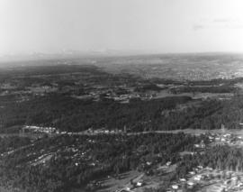
One of a series of photographs taken by air on January 2, 1972, of the Puyallup-area neighborhoods of 112th & Meridian and vicinity. Tall evergreens blanket the area with a few homes carved out of the forests. Photograph ordered by Puget Sound National Bank.
Another in a series of photographs taken by air on January 2, 1972, of the Meridian South & 112th St. neighborhoods. The landscape would change in the following years as the area started to expand. Photograph ordered by Puget Sound National Bank.
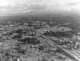
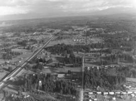
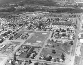
This is an aerial of roughly the future location of the South Hill Mall area in January of 1972. Running vertically in the center of the photograph is 112th St. Meridian is the street that intersects 112th. Other than the cluster of homes on the left, much of the area is still very rural and wooded. Photograph ordered by Puget Sound National Bank.
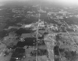
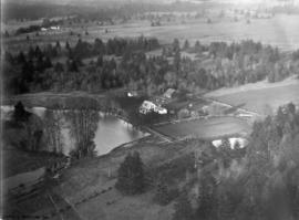
Aerial view of Puyallup Valley taken on January 2, 1972. This is roughly around the Meridian South vicinity; nestled among tall firs is a water tower visible at bottom of photograph. Photograph ordered by Puget Sound National Bank.
Aerial views; Neighborhoods--Puyallup--1970-1980; Water towers--Puyallup;
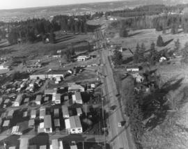
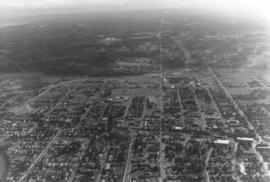
Aerial view of the Puyallup neighborhoods taken in January of 1972; the Western Washington Fairgrounds are located at Meridian South and 9th Ave. S.W. near center-right. Acres of trees at upper left-center. Photograph ordered by Puget Sound National Bank.
Aerial views; Neighborhoods--Puyallup--1970-1980; Western Washington Fair (Puyallup);
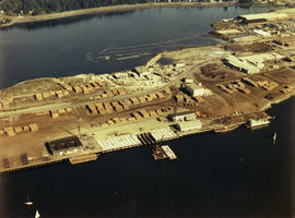
Copy of customer print. Aerial view of the Tacoma industrial tideflats in August of 1975 featuring the Hylebos Waterway at top and the Blair (formerly Port Industrial) Waterway below. There are numerous stacks of lumber in the yards between the two waterways. Color photograph ordered by Westrade, Inc.
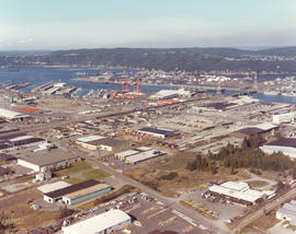
1976 Richards color stock footage. Aerial view in October of 1976 of the city's industrial tideflats and businesses bordering the Hylebos and Blair (formerly Port Industrial) Waterways. Bright orange cranes and large containers provide a splash of color amidst the industrial facilities.
Aerial views of Lakewood neighborhoods near the Villa Plaza Shopping Center were taken on behalf of Newman Properties on June 1, 1976. This particular photograph captures the area around 47th Avenue and Lakeview Avenue. Lakeview is the street running vertically near the right side of picture; 47th borders the Lakeview Elementary School near the center. The cluster of large buildings near the top are part of the Naval Supply Depot which is now the Lakewood Industrial Park.
1975 Richards color stock footage. This aerial photograph is possibly of an automobile unloading facility in South King County. Rows of cars look like matchbox toys from this lofty distance. Cars could be easily transported via rail and highway.
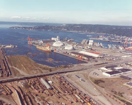
1976 Richards color stock footage of Commencement Bay and industrial tideflats. Aerial view featuring the Port of Tacoma's Kaiser Domes, extended Pier 7, cargo ships and railroad cars was taken on October 4, 1976. Ships were able to pull up next to Pier 7 and unload their shipments of ore to be stored in the two large domes. Railroad cars were in the immediate neighborhood for transporting products.
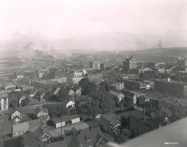
This print from a damaged glass plate negative shows an aerial view of South Tacoma taken in February of 1927. The massive South Tacoma Shops, owned by the Northern Pacific Railway, are located in the center. The plant repaired all Northern Pacific railroad locomotives and cars west of the Mississippi. The shops were composed of 36 separate brick buildings spread out over 15 acres. The grounds were over 1 1/2 miles long, and the work force of 1,250 employees from 20 expert crafts commanded a payroll of $1,500,000 per year. Established in 1890 as Edison Car Shops, the shops closed in 1974. The body of water in the foreground just west of the "shops" was a wetlands area affectionately known to residents of the area as the "South Tacoma Swamp." The road at the right, near the south end of the swamp, is 56th Street. (TNT 02/18/1927, pg. 2)
ca. 1928. A Street at So. 11th St., looking north, in 1928. The Tacoma Building, at right center, was completed in 1911. The building was home to the Weyerhaeuser Timber Co. and the Tacoma Commercial Club. It is currently being restored. The Tacoma Hotel can be seen in the background, located where the Frank Russell Co. building stands today.
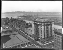
ca. 1928. Elevated view of 1300 block of Pacific Avenue circa 1928. Among the many businesses on Pacific Avenue were the Owl Cafe at 1336 Pacific (lower left) and the Dillion Bldg at 1330-32 Pacific. The familiar spire of the Puget Sound National Bank is to the far right. The Pierce County Courthouse looms in the distance at far left back with the big white walled Greenwich Coliseum (407 So. 13th St.) below. The Greenwich Coliseum had opened in 1927 and would become a premier athletic venue and ballroom.
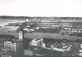
This is how downtown Tacoma and surrounding areas appeared in the fall of 1919. In the foreground are houses and apartments west of Pacific Avenue. A few Tacoma landmarks are clearly visible in the distance: the Puget Sound National Bank building with spire and close to the 11th St. Bridge (now Murray Morgan Bridge), the Tacoma Building and the Perkins Building. Smoke billows from the various industrial plants and lumber mills in the Tideflats across the City (now Thea Foss) Waterway. G8.1-026;
Aerial views; Aerial photographs; Cityscapes; Puget Sound National Bank (Tacoma); Tacoma Building (Tacoma); Perkins Building (Tacoma); 11th Street Bridge (Tacoma);
ca. 1920. Aerial view of the north side of Lakeview (now Lakewood) area, looking east, as photographed by Barnes Aviation in 1920. Building at left edge near center is Lakeview School. The road running left to right though the image is Pacific Highway with Northern Pacific Railroad tracks next to the road. This part of Lakewood was not highly developed at the time.
Aerial photographs; Aerial views; Lakeview School (Tacoma); Streets--Lakewood; Railroad tracks--Lakewood;
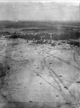
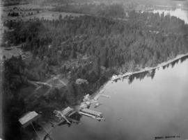
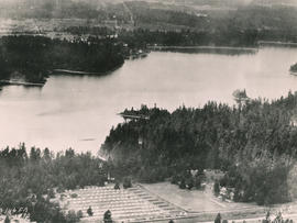
ca. 1920. Unidentified farm on unidentified lake probably in the Lakewood/Spanaway region of Pierce County. Aerial photograph was taken circa 1920 by the Barnes Aviation Co.
North side of American Lake. This area view was taken by Barnes Aviation Co. in the spring of 1920. The large building on the waters edge at the bottom of the photo is the American Lake Boathouse. Hiding in the trees just above the Boathouse is the American Lake Inn. Both buildings have since been demolished. The boathouse, called Martin's American Lake Boathouse, was destroyed in a supervised burn by the Lakewood Fire Department in June of 1955. The boathouse had been built around the turn of the 20th century and served the community for many years as a recreational center for boating and fishing and as the site for dances and social functions. It gradually deteriorated and plans were made to replace it with a modern structure. The American Lake Inn was also built in the first decade of the 20th century. By May of 1904, the 20-room resort was open for business. It was owned by Mrs. H.I. Nolan. Included was a handsome pavilion for exclusive use of the Inn's guests. (TNT 6-19-1955- article on boathouse burn; TDL 5-29-04, p. 7-article on American Lake Inn)
American Lake (Wash.); Aerial photographs; Aerial views; American Lake Boathouse (Lakewood); American Lake Inn (Lakewood);
Aerial view of 146th F.A. tents on June 26, 1930. The 146th Field Artillery were participating in the 1930 encampment at Camp Murray. The two-week encampment of the Washington National Guard would last until June 28th. 2600 officers and men, including some 400 Tacomans, would participate in these annual summer maneuvers. Lake in background is American Lake. G77.1-040 (TNT 6-13-30, p. 1-article on encampment)
Aerial photographs; Aerial views; Washington National Guard, 148th F.A. (Tacoma); American Lake (Wash.);
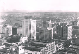
This May, 1931, aerial view of Tacoma's City Center was taken from the industrial Tideflats. The 11th Street Bridge (now Murray Morgan Bridge) is on the right. Jutting into the skyline are (l-r) the Pierce County Courthouse, Puget Sound National Bank, Washington Building, Tacoma Building, and the Art-Deco styled 17-story newly completed Medical Arts Building in the right background. TPL-1788; G91.012
Cityscapes; Aerial views; Aerial photographs; 11th Street Bridge (Tacoma); Pierce County Courthouse (Tacoma); Puget Sound National Bank (Tacoma); Washington Building (Tacoma); Tacoma Building (Tacoma); Medical Arts Building (Tacoma);
View of Tacoma Tideflats from the top of the Medical Arts Building. The City Waterway can be seen in the background. City Hall, with its distinctive clock tower, is clearly visible. This photograph was taken on April 5, 1931.
Aerial photographs--1930-1940; Cityscapes--1930-1940; City Waterway (Tacoma); Old City Hall (Tacoma);
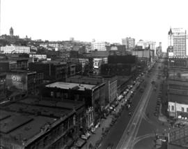
View of downtown business district of Tacoma looking southeast from the top of the Medical Arts Building as seen on April 5, 1931. Good view of the fronts of the buildings on the east side of Broadway between 9th and 11th.
Aerial photographs--1930-1940; Business districts--Tacoma--1930-1940;
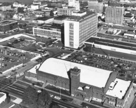
County-City Building. Close-up view of the County-City Building with two its wings - law enforcement on the left and courts on the right with the 12-story central structure between. Also in this October 4, 1969, aerial view is the Washington National Guard Armory in the photograph's foreground. The brick edifice was dedicated on the first day in January, 1909, and remodeled several times since then. Located in the 700 block of So. 11th St., it was across the street from the L.H. Bates Vocational-Technical Institute (formerly Tacoma Vocational). Photograph ordered by Whitacre Engineers.
Aerial views; County-City Building (Tacoma); State Armory (Tacoma); Commercial streets--Tacoma--1960-1970;
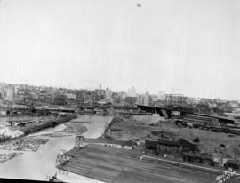
Aerial view of industrial Tideflats area around East D St. between City (now Thea Foss) Waterway and Middle Waterway on October 16, 1969. Fick Foundry (center) had long been an occupant at 1005 East D with Richfield Oil across the street. The building right of Fick is the Junior Line Furniture Co., 1017 East D. The large plant above Fick Foundry is the Coast Sash & Door Co., 1002 East F St. It was later known as Coastcraft. Photograph ordered by Winston Fournier & Associates, Dallas. (Additional identification provided by a reader) TPL-10293
Aerial views; Fick Foundry Co. (Tacoma); City Waterway (Tacoma); Middle Waterway (Tacoma); Commercial streets--Tacoma--1960-1970; Coast Sash & Door Co. (Tacoma); Junior Line Furniture Co. (Tacoma); Richfield Oil Corp. (Tacoma);
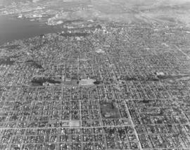
Aerial look of the populous North end and downtown area of Tacoma in 1970, including glimpse of Commencement Bay and bustling industrial Tideflats. This view is looking east over the city's landscape. I-5 is toward the right corner. University of Puget Sound is in the center. Photograph ordered by Puget Sound National Bank. TPL-9668
Aerial views; Neighborhoods--Tacoma--1970-1980; University of Puget Sound (Tacoma)--1970-1980; Commencement Bay (Wash.);
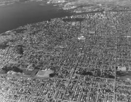
On February 20, 1970, several aerial photographs of North Tacoma were taken on behalf of Puget Sound National Bank. They showed the north end residential neighborhoods extending to Commencement Bay. The beautiful campus of the University of Puget Sound and adjacent Baker Stadium and Fieldhouse are located in the lower left-center. Wright Park is the large wooded area close to downtown Tacoma.
Aerial views; University of Puget Sound (Tacoma)--1970-1980; Wright Park (Tacoma); Commencement Bay (Wash.);
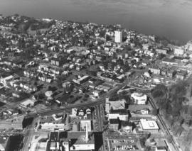
A February, 1970, photograph taken on a sunny winter day looking north toward Commencement Bay showed the north end Stadium District. Wright Park, located around Sixth & "I," is on the right lower edge. Across the street from the park is the Greek-ionic styled First Church of Christ, Scientist. The Washington State Historical Society building, Stadium Bowl and Stadium High School are near the right upper edge. The white tower in the upper center is the Vista Manor Apartments; built in 1950, Vista Manor had some outstanding views of the bay. Next door to the Vista Manor at 409 Tacoma Ave. No. is the Central Lutheran Church. A portion of Tacoma General Hospital can be seen at the bottom of the photograph. Photograph ordered by Puget Sound National Bank.
Aerial views; Wright Park (Tacoma); First Church of Christ, Scientist (Tacoma); Stadium High School (Tacoma); Stadium Bowl (Tacoma); Washington State Historical Society Building (Tacoma); Vista Manor Apartments (Tacoma); Commencement Bay (Wash.);
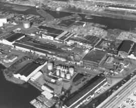
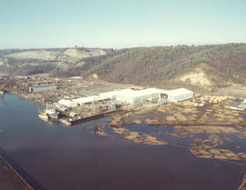
ca. 1973. 1973 Richards stock footage. A look by air at the shipyard believed to be Tacoma Boatbuilding, located at 1840 Marine View Dr. N.E., overlooking the Hylebos Waterway. Built on a spacious 20-acre site in 1969, the shipyard was able to expand production of extra-large fishing boats as well as complete government contracts. Tacoma Boatbuilding had decided to move operations to this Hylebos Waterway location after fire had destroyed their plant on the Sitcum Waterway in 1968.
Aerial views; Boat & ship industry--Tacoma--1970-1980; Tacoma Boat Building Co., Inc. (Tacoma); Logs; Hylebos Waterway (Tacoma);
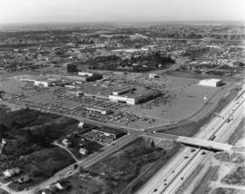
Aerial view of Tacoma's largest shopping center, the Tacoma Mall, on April 2, 1973. Traffic on I-5 flows quickly along and there was easy access to the shopping center. South 48th St. with its overpass over I-5 intersects with South Ferry at the Mall. The Allstate Insurance Co.district office is the large building at the southwest corner of South 48th & Ferry. The wooded area next to Allstate would later be developed. This view, looking north, shows the Mall in its entirety, including the separate structures of the Tacoma Mall Theatre, Pacific National Bank of Washington, and the Tacoma Mall Office Building. With 83 acres of land, there was plenty of room for free parking and also for later expansion. Rhodes department store had already announced plans to open a branch at the Mall; it would be built on the extreme far west section. This aerial also shows the Mall's surrounding neighborhoods including Lincoln Heights off 38th St. past the grove of evergreens. Photograph ordered by Puget Sound National Bankl.
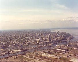
Aerial view of the City of Tacoma as seen from the industrial Tideflats. The City (now Thea Foss) Waterway separates the bustling industrial area from Tacoma's downtown business district. This May, 1974, photograph aptly captures how the ready availability of rail, water, and highway transport attracted such companies as Hooker Chemicals and St. Regis to Tacoma.
Aerial photographs; Aerial views; City Waterway (Tacoma); Business districts--Tacoma--1970-1980; Industrial facilities--Tacoma;