- Item
- 1941-07-20
Part of Richards Studio Photographs
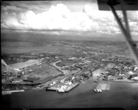
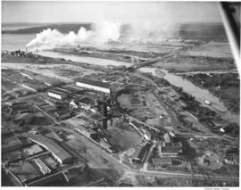
Aerial view in July of 1941 of industrial section of Tacoma from Commencement Bay looking eastward with focus on various waterways.
Aerial views; Aerial photographs; Waterways;
824 results with digital objects Show results with digital objects
Part of Richards Studio Photographs
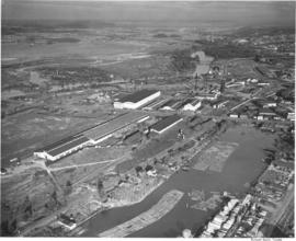
Aerial view in July of 1941 of industrial section of Tacoma from Commencement Bay looking eastward with focus on various waterways.
Aerial views; Aerial photographs; Waterways;
Part of Richards Studio Photographs
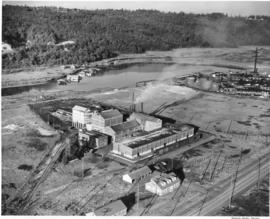
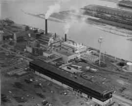
An aerial view of the Feltrok Insulation Manufacturing Company taken at 7 p.m. June 9, 1950. The company was located on the Tacoma tideflats. Pennsylvania Salt Manufacturing Company is seen on the right. Feltrok was purchased by the American Rock Wool Corporation in 1952. About 35 persons were employed in the Tacoma operation at that time. (Tacoma Reporter, 7/21/1952, p.3)
Aerial photographs; Feltrok Insulation Manufacturing Co. (Tacoma); Industrial facilities--Tacoma--1950-1960; Pennsylvania Salt Manufacturing Co. of Washington (Tacoma);
Part of Richards Studio Photographs
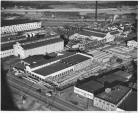
An aerial view of St. Paul and Tacoma Lumber Company. Colonel Chauncey Griggs, Addison Foster, Henry Hewitt, Jr. and Charles Hebard Jones purchased 83,000 acres of timber in 1888 from the Northern Pacific Raillroad company in the largest purchase of timberland in the nineteenth century. Then they built a giant sawmill on "The Boot", a low island off the main tideflats, bordered by branches of the Puyallup River and Commencement Bay. They built the first standard-guage logging railroad and introduced the band-saw to Pacific Northwest lumber operations. They built the St. Paul & Tacoma Lumber Company. (The Mill on the Boot, Murray Morgan)
Aerial photographs; Lumber industry--Tacoma--1950-1960; St. Paul & Tacoma Lumber Co. (Tacoma);
Part of Richards Studio Photographs
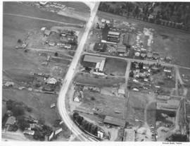
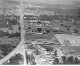
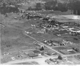
ca. 1950. Aerial view of Steilacoom Blvd. near South Tacoma Way was taken probably in the fall of 1950. Although houses and businesses dot the landscape, there was still plenty of room for expansion.
Aerial photographs; Commercial streets--Tacoma--1950-1960; Land--Tacoma--1950-1960;
Part of Richards Studio Photographs
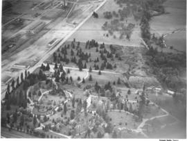
ca. 1950. Aerial view of Mountain View Cemetery on Steilacoom Blvd.; photograph taken probably in the fall of 1950. The Pacific Naval Advance Base, also known as the Lakewood Navy Yard, lies across the street. Mountain View was a very large memorial park; among its facilities included a cemetery, funeral home, chapel, crematorium and mausoleum. According to an advertisement in the 1951 City Directory, a mourner could place complete responsibility in the very capable hands of Mountain View.
Aerial photographs; Mountain View Memorial Park (Lakewood); Pacific Naval Advance Base (Lakewood); Lakewood Navy Yard (Lakewood);
Part of Richards Studio Photographs
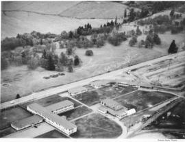
ca. 1950. Aerial photograph of Pacific Naval Advance Base in Lakewood taken probably in the fall of 1950. Mountain View Cemetery with its expansive grounds lies across the street on Steilacoom Blvd. The Navy acquired the land to build its base in 1944; previously it had been used for the Tacoma Municipal Airport. The Pacific Naval Advance Base was also known more familiarly as the Lakewood Navy Yard.
Aerial photographs; Pacific Naval Advance Base (Lakewood); Lakewood Navy Yard (Lakewood); Mountain View Memorial Park (Lakewood);
Part of Richards Studio Photographs
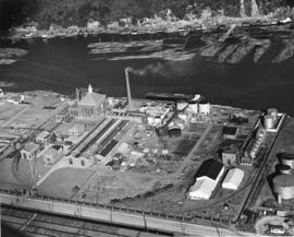
Aerial view shows progress being made on new construction for the St. Regis Paper Company in September, 1950. Established as a company in 1899, St. Regis was open for business in Tacoma in 1928. Rebuilt and modernized in 1936, St. Regis bought additional acreage from the St. Paul Tacoma Lumber Company in 1947 to add a paper mill and multi wall bag plant. According to the St. Regis 1950 annual report, Tacoma's expansion of their pulp mill would enlarge the pulp capacity from 115,000 to 135,000 tons a year. The new capacity will be in production in 1951.
St. Regis Paper Co. (Tacoma)--1950-1960; Paper industry--Tacoma--1950-1960; Factories--Tacoma--1950-1960; Progress photographs--1950-1960; Aerial photographs;
Part of Richards Studio Photographs
This aerial photograph from November 1948 shows the Hooker Electrochemical Company located at 605 Alexander Avenue on the Tacoma tideflats. The waterway above the plant, dotted with log booms, is the Hylebos Waterway. Small houses and businesses line the shore on the other side of the waterway along Marine View Drive. Hooker changed its name to Occidental Chemical Co. in 1982. In 1997 the company was purchased by Pioneer Companies Inc.; the plant closed in 2002. TPL-7977
Aerial photographs; Hooker Electrochemical Co. (Tacoma); Chemical industry--Tacoma--1940-1950; Logs; Hylebos Waterway (Tacoma); Harbors--Tacoma; Factories--Tacoma--1940-1950;
Part of Richards Studio Photographs
Aerial view of West Coast Grocery, St. Paul and Tacoma Lumber Company and Tacoma Iron and Steel. A view of the Tacoma tideflats and some of the industry built on it looking northwest. Log booms are seen in the waterways. One of the bridges on the Puyallup River is open. TPL-5892
Tacoma Tideflats (Tacoma); Aerial photographs; Puyallup River (Wash.); Industry--Tacoma--1940-1950;
Part of Richards Studio Photographs
Aerial view of West Coast Grogery, St. Paul and Tacoma Lumber Company and Tacoma Iron and Steel. A view of the Tacoma tideflats and some of the industry built on it looking east. Log booms are seen in two of the waterways. TPL-3215 and TPL-3659
Tacoma Tideflats (Tacoma); Aerial photographs; Puyallup River (Wash.); Industry--Tacoma--1940-1950;
Part of Richards Studio Photographs
Permanente Metals, producers of Kaiser Aluminum, bought the Olin plant and after rehabilitating and improving the facilities, they have started production. They began operating one pot line, but within a month they should be producing aluminum at full capacity. The Tacoma plant is one of the most modern aluminum producing facilities in the country. Aerial view of Permanente, which is located on the Tacoma Tideflats, covering more than 129 acres of land (PMC Annual Report, 1947-48).
Aerial views; Industrial facilities--Tacoma; Aluminum industry--Tacoma--1940-1950; Permanente Metals Corp. (Tacoma);
Part of Richards Studio Photographs
The Auto-View Theater was located on South Tacoma Way and South 99th Street. At 9915 South Tacoma Way was the Motel Fontaine, at the bottom center in this photograph. Aerial view of available area, neighborhoods and the Auto-View Theater (right side), all located along South Tacoma Way (T. Times, 8/31/48, p. 21).
Cities & towns--Tacoma; City & town life--Tacoma; Aerial views; Aerial photographs; Neighborhoods--Tacoma; Drive-in theaters--Tacoma; Auto-View Theater (Tacoma); South Tacoma Way (Tacoma);
Part of Richards Studio Photographs
Cooperation between South Tacoma employers and employees have played an important role in the steady growth of this south side community. South Tacoma businesses and industries have helped raise the overall payroll of the city. View of available area, neighborhoods and the Star-Lite Park In Theatre located along South Tacoma Way (T. Times, 8/31/48, p. 21).
Cities & towns--Tacoma; City & town life--Tacoma; Aerial views; Aerial photographs; Neighborhoods--Tacoma; Drive-in theaters--Tacoma; Star-Lite Park In Theatre (Tacoma); South Tacoma Way (Tacoma);
Part of Richards Studio Photographs
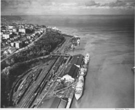
This aerial photograph shows the Tacoma shoreline looking north from the mouth of the City Waterway (Thea Foss Waterway) as it looked in October of 1948. Ships are taking on cargo at the terminals along Dock Street and the Shaffer Terminals on Bay Side Drive along the waterfront at the foot of Division Avenue. Boxcars fill the tracks in the Northern Pacific "half-moon yard". The Fourth Street Bridge provides access over the railroad tracks from Dock St. to Bay Side Drive. The smokestack in the distance is from the ASARCO facilities. This area was dramatically transformed with the building of I-705 and the Schuster Parkway.
Aerial photographs; Shaffer Terminals, Inc. (Tacoma); Marine terminals--Tacoma; Smokestacks--Tacoma;
Part of Richards Studio Photographs
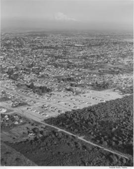
Studio stock negatives. An aerial view of residential neighborhoods in Pierce County. New housing developments with no or few trees are in the foreground.
Aerial photographs; Land; Land use--Tacoma--1940-1950; Housing developments--Tacoma--1940-1950;
Part of Richards Studio Photographs
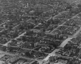
On August 18, 1948, the Richards Studio photographer flew around the city of Tacoma taking shots of various neighborhoods and individual streets. This aerial view is of S. 15th & Market Sts. near downtown Tacoma. The street running left to right at the bottom is 15th St. The light colored street at center is Market St. The Labor Temple, built circa 1941, is at the corner of 15th & Market (actual address of 1355 Market St.)
Aerial photographs; Aerial views; Neighborhoods--Tacoma--1940-1950; Labor Temple (Tacoma); Streets--Tacoma--1940-1950;
Part of Richards Studio Photographs
Aerial view, taken in August of 1948, of the large St. Regis Paper Co. plant located in Tacoma's industrial Tideflats. Waterway in center is the Puyallup Waterway. St. Regis was undergoing expansion as depicted by the unfinished building in the foreground. Three years later a big new bag plant would be built, adding to Tacoma's payroll.
Aerial photographs; Aerial views; St. Regis Paper Co. (Tacoma)--1940-1950; Paper industry--Tacoma--1940-1950; Industrial facilities--Tacoma--1940-1950; Building construction--Tacoma--1940-1950; Puyallup Waterway (Tacoma);
Part of Richards Studio Photographs
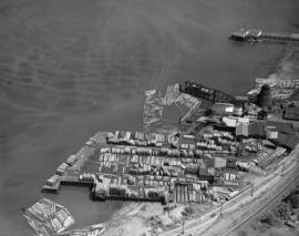
This aerial photograph shows the Dickman Lumber Company at 2423 Ruston Way as it looked in 1948. Built as the Young Brothers Shingle Mill in 1899, Ralph L. Dickman Sr. and Leonard Howarth purchased the mill in 1922. The Dickman mill remained in operation until 1977 when rising costs, competition from larger companies, and the unavailability of specialized logs forced the company to close. They were the last mill on Tacoma's "old town" waterfront. The mill was destroyed by fire in January of 1979, and the land on which the mill stood is now the Dickman Mill Park. (History of Pierce County, Vol. 1, p. 11-13)
Aerial photographs; Dickman Lumber Co. (Tacoma); Lumber industry--Tacoma--1940-1950; Logs;
Part of Richards Studio Photographs
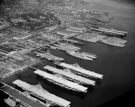
Aerial view of Bremerton Shipyard, also known as Puget Sound Naval Shipyard, in August, 1948, including harbor, aircraft carriers and ships. Established in 1891 as a naval station, the Puget Sound Naval Shipyard originally opened as a repair facility but expanded in WWI to accommodate shipbuilding. During WWII, its primary business was in repairing battle-damaged ships of the US fleet and those of its allies. New construction appeared limited to smaller vessels such as destroyer escorts as the yard performed much work in modifying and upgrading ships. Following WWII, the shipyard was busy modernizing carriers, including conversion of conventional flight decks to angled decks. During the war years, Puget Sound Naval Shipyard had five large drydocks (a sixth was added later) and four new shipbuilding ways for construction of escort vessels. It is located adjacent to the city of Bremerton and covers 327 acres of hard land and 338 acres of submerged land. (www.globalsecurity.org/military/facility/puget_sound-nsy.htm)
Aerial photographs; Naval yards & naval stations--Bremerton; Government vessels--Bremerton; Marine terminals--Bremerton; Puget Sound Naval Shipyard (Bremerton);
Part of Richards Studio Photographs
Aerial view of Tacoma Lumber Fabricating Co. on Old Town waterfront. This is an August, 1948, view of the Tacoma Lumber Fabricating Co. including stacks of lumber. Tacoma Lumber was situated on the former site of Henry Mill & Timber Co. on No. Starr St. It had taken over the business in August, 1945. Realizing the need for more affordable, quicker construction of new homes after WWII, Tacoma Lumber expanded its structural beam business to include the creation of panels for entire prefabricated houses. By the early 1950's, Tacoma Lumber was gone from No. Starr St., replaced by Pacific Oerlikon Co., manufacturers of electric equipment.
Aerial photographs; Tacoma Lumber Fabricating Co. (Tacoma); Lumber industry--Tacoma--1940-1950;
Part of Richards Studio Photographs
This is the neighborhood surrounding the Old St. Joseph Hospital as viewed by air in August of 1948. The hospital is at the upper center of the photograph at 1812 South "I" St. St. Nicholas Greek Orthodox Church, with its dome, is on the right edge of the photograph at 1523 Yakima Ave. So.
Aerial views; Aerial photographs; Neighborhoods--Tacoma--1940-1950; St. Joseph Hospital & School of Nursing (Tacoma); St. Nicholas Greek Orthodox Church (Tacoma); Streets--Tacoma--1940-1950;
Part of Richards Studio Photographs
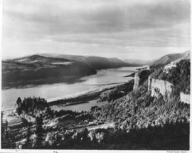
Aerial photograph of the scenic Columbia River was taken on August 17, 1951. Shadows are falling on the rocky tree-covered hills. There does not appear to be any river traffic at this particular moment in time.
Aerial photographs; Columbia River (Wash.); Rivers--Washington (State);
Part of Richards Studio Photographs
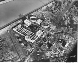
Aerial photograph of sewage disposal plant. Progress was being made in the construction of a new waste disposal facility on Cleveland Way near the Puyallup River in October, 1951. Aerial view of plant; large circular structures are digesting tanks, square building between them the digestion control building. Raw sludge would be processed in the digesting tanks where ultimately it would be filtered, peeled off in cakes, and then hauled away for fertilizer. According to a 12/12/51 article in the News Tribune, the plant was designed to handle 27 million gallons of sewage a day. Photograph commissioned by Hoagland-Findlay. TPL-8825
Aerial photographs; Progress photographs; Building construction--Tacoma--1950-1960; Sewerage--Tacoma; Waste disposal facilities--Tacoma; Hoagland-Findlay Engineering Co. (Seattle);
Part of Richards Studio Photographs
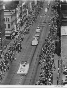
Aerial view of 1952 Daffodil Parade as it proceeds down Pacific Avenue. The day of the parade dawned clear and sunny, prompting 200,000 Tacomans to line the parade route. People stood 10 deep at prime viewing spots, with others watching from windows, awnings, hanging from fire escapes and perching on roofs.
Celebrations--Tacoma; Festivals--Tacoma; Parades & Processions--Tacoma--1950-1960; Puyallup Valley Daffodil Festival (1952 : Tacoma); Drill teams; Marching bands; Floats (parades)--Tacoma--1950-1960; Aerial photographs;
Part of Richards Studio Photographs
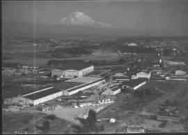
This aerial view of the St. Paul & Tacoma Lumber Company shows Mount Rainier in the background. Included in the photograph are the sawmill, lumber storage and shipping sheds, planing mill, dry kilns, and the barking and chipping plant. The log storage and sorting ponds, railroad log dumps, deep water shipping dock and shed are not shown, as the plant covers an area of 180 acres, about 1/4 mile wide and a mile long. The company sprawled along the St. Paul Waterway, to the left of this photograph, between St. Paul and Portland Avenues. The Puyallup River can be seen heading east with several bridges crossing it. Ordered by St. Paul & Tacoma Lumber Company. (Tree Life Hemlock, St. Paul & Tacoma Lumber Co.)
Aerial photographs; St. Paul & Tacoma Lumber Co. (Tacoma); Cityscapes; Lumber industry--Tacoma--1950-1960;
Part of Richards Studio Photographs
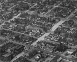
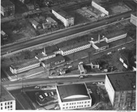
Aerial photographs were taken of Jefferson Avenue in November, 1951. Building on the right hand corner belongs to Blake, Moffitt & Towne, wholesale distributors of printing and wrapping paper. Rectangular two-story buildings in center of photograph are probably structure known as "Jefferson House", built originally in 1945 to provide emergency accomodations for single men. Jefferson Avenue was primarily a business district, filled with apartment buildings and manufacturers. Photograph ordered by John Huston.
Aerial photographs; Cityscapes; Commercial streets--Tacoma--1950-1960;
Part of Richards Studio Photographs
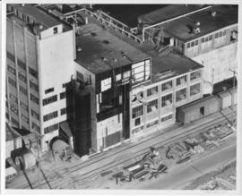
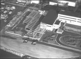
Aerial photograph to show the steel work on a new building at St. Regis, Tacoma. Construction of a bag plant at the St. Regis Paper company started in June 1951 with the driving of piling as the first step. The addition was built of steel and concrete and would be used for the production of industrial-use bags for cement, fertilizer and other materials needing heavy-duty holders. When completed, this plant would replace the leased plant at Seattle. (TNT 6/15/1951; St. Regis Paper Company 1951 Annual Report)
St. Regis Paper Co. (Tacoma)--1950-1960; Progress photographs; Building construction--Tacoma--1940-1950; Aerial photographs; Paper industry--Tacoma--1950-1960;
Part of Richards Studio Photographs
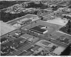
An aerial photograph of the Northgate shopping area. The building in the center of this June, 1951, photograph contains Larson's Department Store and Ridgecrest Super Market. Ordered by Phares Advertising. The area is mixed use with single-family residential areas near this commercial area.
Aerial photographs; Shopping centers--Seattle; Land use--Seattle--1950-1960; Real estate development--Seattle--1950-1960;
Part of Richards Studio Photographs
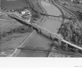
Another view of the bridges crossing the Puyallup River was taken via air by Richards Studio on April 22, 1958. Water levels indicate that the river had not overflooded its borders. There are no buildings directly on the river's edge because of the flooding potential. The white or light gray colored bridge has been identified as the Eells St. bridge looking south. From above it appears to have an open geometric design; the curvature on top is reminiscent of a roller coaster track. It connected Pacific Highway and Fife to the left and Puyallup Ave. and Tacoma to the right. The other two bridges were railroad bridges and still there some fifty years later. (Additional identification provided by a reader)
Aerial photographs; Bridges--Tacoma--1950-1960; Railroad bridges--Tacoma; Eells St. State Highway Bridge (Tacoma); Puyallup River (Wash.);
Part of Richards Studio Photographs
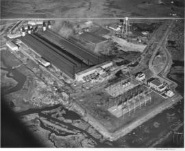
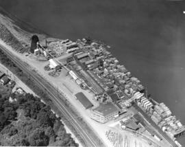
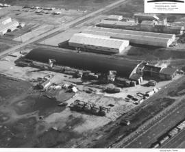
Woodlam, Inc., was a laminated wood products company located in the Tideflats at 1476 Thorne Rd. William Lindberg was listed as president in the 1959 City Directory. Woodlam was formerly known as Laminated Wood Products Co. and was owned by Arne Strom. Strom had opened the plant in February, 1957, and sold the facility to Lindberg in April, 1958. Woodlam, Inc., employed between 80-100 workers. Purchase of the plant involved eight acres of land, a 500 X 100 foot main plant, drying kilns and a suite of offices. Aerial photographs were taken on April 10, 1958, showing piles of plywood outside the large plant facilities. Railroad tracks close by meant easy rail access for the laminated products. Photograph ordered by Woodlam, Inc. (TNT 4-26-58, A-1)
Aerial photographs; Woodlam, Inc. (Tacoma);