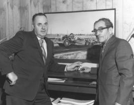
On January 8, 1972, two unidentified men stood in what may be in an engineering or assessor's office. Large photograph of Caterpillar on paneled wall; adjoining the photograph is a portion of a map. Contract plans, among other documents, are on desk shelf. Photograph ordered by Standard Insurance Co.
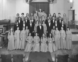
The 42-member University of Puget Sound Adelphian Choir pose before the stage at Jacobsen Recital Hall on January 5, 1972. This is the same photograph as A161331, image 2, but the background in this particular photograph has not been retouched. Chairs on stage, lights, organs and audience seating all are visible. Photograph ordered by the University of Puget Sound, School of Music.
Adelphian Choral Society (Tacoma); Choirs (Music); Students--Tacoma--1970-1980; University of Puget Sound (Tacoma)--1970-1980;
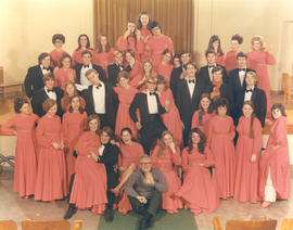
The 42-voice Adelphian Choir composed of University of Puget Sound students let loose with a definitely less solemn group portrait. Founder and director Dr. Bruce Rodgers (seated in foreground) waves happily as the singers were photographed on January 5, 1972. Photograph ordered by the University of Puget Sound, School of Music.
Adelphian Choral Society (Tacoma); Choirs (Music); Students--Tacoma--1970-1980; University of Puget Sound (Tacoma)--1970-1980;
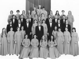
University of Puget Sound's Adelphian Choir posed for a formal portrait in the school's Recital Hall on January 5, 1972. The men wore traditional black tuxedos while the women were dressed in floor length gowns of deep coral. This photograph has been retouched with the background nearly eliminated in favor of pure white, a method to better emphasize the singers. Photograph ordered by the University of Puget Sound, School of Music.
Adelphian Choral Society (Tacoma); Choirs (Music); Students--Tacoma--1970-1980; University of Puget Sound (Tacoma)--1970-1980;
Stacks of large rolls of Chiffon paper towels make an impressive display at Manley's Supermarket in the Thunderbird Shopping Center on January 4, 1972. The paper towels are manufactured by Crown Zee. Two unidentified men hold additional strips to be placed on the display stand, alerting customers that these paper towels are advertised in Sunset magazine for Western families. Photograph ordered by Lane Magazine & Book Co., Menlo Park, CA.
Merchandise display--Lakewood--1970-1980; Paper products; Manley's Supermarket (Lakewood); Signs (Notices);
Refurbishment of London Loan Office, 1310 Pacific Ave. This segment of Pacific Avenue in early 1972 boasted at least three pawnbrokers in a row: Pacific Loan & Jewelry, London Loan Office and Western Loans. A Zeon Sign Co. truck is parked alongside the pawnbrokers on January 3, 1972, with ladder extended to the top of the London Loan. It is possible that a new sign will be erected at the site. Color photograph ordered by Epcon.
Pawnshops--Tacoma; London Loan Office (Tacoma); Western Loans (Tacoma); Pacific Loan & Jewelry (Tacoma); Trucks--Tacoma--1970-1980;
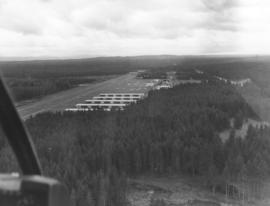
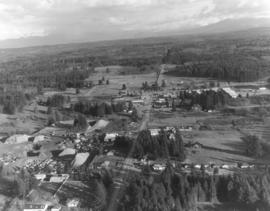
This is possibly Thun Field, just south of the City of Puyallup in the South Hill neighborhood. The air field appears to be hemmed in by tall firs. Photograph taken on January 2, 1972; ordered by Puget Sound National Bank.
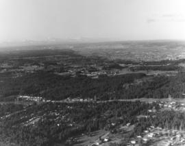
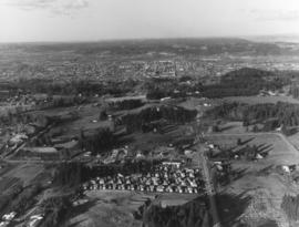
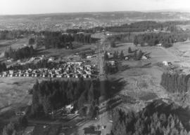
One of a series of photographs taken by air on January 2, 1972, of the Puyallup-area neighborhoods of 112th & Meridian and vicinity. Tall evergreens blanket the area with a few homes carved out of the forests. Photograph ordered by Puget Sound National Bank.
Another in a series of photographs taken by air on January 2, 1972, of the Meridian South & 112th St. neighborhoods. The landscape would change in the following years as the area started to expand. Photograph ordered by Puget Sound National Bank.
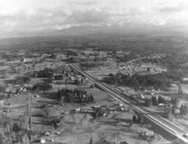
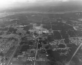
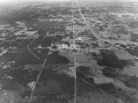
This is an aerial of roughly the future location of the South Hill Mall area in January of 1972. Running vertically in the center of the photograph is 112th St. Meridian is the street that intersects 112th. Other than the cluster of homes on the left, much of the area is still very rural and wooded. Photograph ordered by Puget Sound National Bank.
Aerial view of Puyallup Valley taken on January 2, 1972. This is roughly around the Meridian South vicinity; nestled among tall firs is a water tower visible at bottom of photograph. Photograph ordered by Puget Sound National Bank.
Aerial views; Neighborhoods--Puyallup--1970-1980; Water towers--Puyallup;
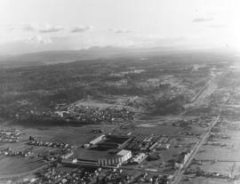
Aerial view of the Puyallup neighborhoods taken in January of 1972; the Western Washington Fairgrounds are located at Meridian South and 9th Ave. S.W. near center-right. Acres of trees at upper left-center. Photograph ordered by Puget Sound National Bank.
Aerial views; Neighborhoods--Puyallup--1970-1980; Western Washington Fair (Puyallup);
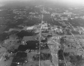
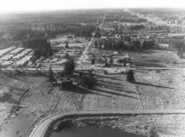
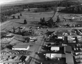
This aerial view of the Puyallup neighborhoods near 112th & Meridian was taken by the Richards Studio on January 2, 1972, on behalf of Puget Sound National Bank. Sand and gravel pit on the left; sprinkling of homes and businesses nearby.
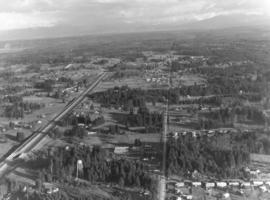
Another in a series of aerials of the area around 112th & Meridian in early 1972. In the late 1980s, the South Hill Mall would be built about this location. Photograph ordered by Puget Sound National Bank.
This is what the 112th & Meridian area looked like in early 1972. The South Hill Mall would be built 16 years later on Meridian. What is noticeable is the large amount of woods and relatively few homes. Aerial photograph ordered by Puget Sound National Bank.
The 112th & Meridian neighborhoods as seen by air in January of 1972. At that time there was an abundance of wooded acreage and not many homes. Photograph ordered by Puget Sound National Bank.
Closer view of Puyallup neighborhood about 9th Ave. S.W. and Meridian South with Western Washington Fairgrounds in lower center. This photograph, one of a series, was taken on January 2, 1972, on behalf of Puget Sound National Bank.
Aerial views; Neighborhoods--Puyallup--1970-1980; Western Washington Fair (Puyallup);
A Richards Studio photographer flew over the vicinity of 112th & Meridian on a clear January day in 1972 to take a series of photographs of this Puyallup-area neighborhood. Photograph ordered by Puget Sound National Bank.
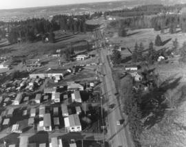
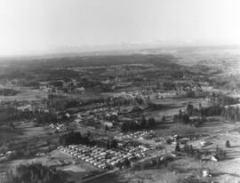
A look by air at the 112th & Meridian South neighborhood in Puyallup in the early part of January, 1972. On the left appears to be a trailer court. Photograph ordered by Puget Sound National Bank.
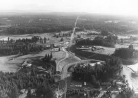
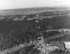
Aerial view in January of 1972 of "Willows Corner," about 112th & Meridian St. Building labeled "Flea Mart," on the right side, was the former Willows Tavern/The Willows. Builder J.J. Mabbott was responsible for the "pavilion" built near Puyallup in 1927. The area around 112th & Meridian would be greatly developed in the future, with the South Hill Mall being constructed in 1988. Photograph ordered by Puget Sound National Bank.
Aerial view of relatively unpopulated 112th & Meridian area, showing location of the future South Hill Mall. Abundance of trees cover the land, much of which was later developed. Hwy. 512 is curving road parallel to 112th. Photograph ordered by Puget Sound National Bank.
Aerial view of the 112th & Meridian neighborhood in January of 1972. Much of this land has now been developed, particularly since the construction of the South Hill Mall in 1988. Photograph ordered by Puget Sound National Bank.
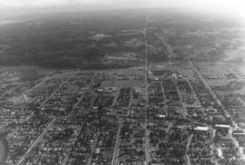
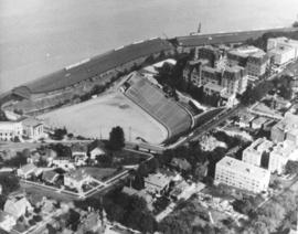
ca. 1971. This is an aerial view of the Stadium district as photographed circa 1971. Stadium Bowl is in the center with Stadium High School on the right and the Washington State Historical Society Museum on the left. Stadium Bowl, built in 1909, has been renovated circa 1980 and been subjected to several damaging mudslides in 1932, 1949, and 1981. It now has a modern capacity of 15,000, downsized from its original seating capacity of 23,486. Stadium Bowl was originally designed by Tacoma architect Frederick Heath. BU-11652
Aerial photographs; Aerial views; Neighborhoods--Tacoma--1970-1980; Stadium Bowl (Tacoma); Stadium High School (Tacoma); Washington State Historical Building (Tacoma);
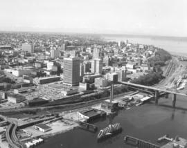
ca. 1971. 1971 Richards stock footage. Aerial photograph of the City of Tacoma in 1971, with emphasis on the downtown business district and City Waterway (now Thea Foss Waterway). Buildings closest to the waterway and the 11th Street Bridge (now Murray Morgan Bridge) include the Perkins and Tacoma Buildings that flank the bridge, the new Pacific National Bank of Washington Plaza tower, the Rust and Washington Buildings. Also visible are the Medical Arts Building (now Municipal Building) and further in the background, the County-City Building. Two new parking garages on Pacific Ave. were completed in 1970-71 providing hundreds of parking spaces and addressing the pleas for more parking stalls.
Aerial views; City Waterway (Tacoma); Cityscapes; 11th Street Bridge (Tacoma); Perkins Building (Tacoma); Tacoma Building (Tacoma); Pacific National Bank of Washington (Tacoma); Rust Building (Tacoma); Washington Building (Tacoma);
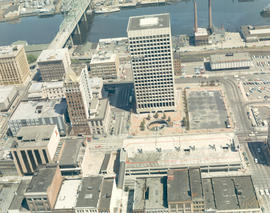
ca. 1971. 1971 color Richards stock footage. Aerial view of downtown business district featuring the new Bank of Washington Plaza with its 24-story tower. Directly across Pacific Avenue from the new skyscraper is the Park Plaza South parking garage, also recently opened with 381 parking stalls. To the left of the Pacific National Bank's Bank of Washington Plaza is the familiar spire of Puget Sound National Bank, once the tallest structure on the West Coast. Also in view is the City (now Thea Foss) Waterway with the 11th St. Bridge (now Murray Morgan Bridge). The Tacoma Building and Perkins Building flank the bridge. TPL-2316
Aerial views; Pacific National Bank of Washington (Tacoma); Puget Sound National Bank (Tacoma); Banks--Tacoma; Parking garages--Tacoma--1970-1980; 11th Street Bridge (Tacoma); Tacoma Building (Tacoma); Perkins Building (Tacoma); City Waterway (Tacoma);
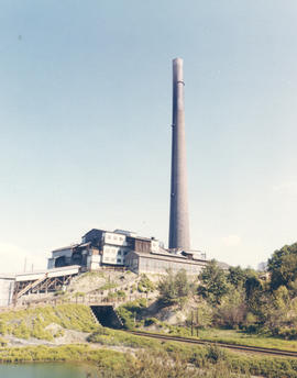
ca. 1971. 1971 Richards color stock footage. A familiar landmark in Tacoma was the imposing smokestack at the ASARCO smelter. It rose over 500 feet at the smelter located near Point Defiance. The smokestack, dubbed the tallest in the world at the time of its 1917 construction, would be demolished on January 17, 1993.
American Smelting & Refining Co. (Tacoma); Smelters--Tacoma--1970-1980; Smokestacks--Tacoma; Industrial facilities--Tacoma;