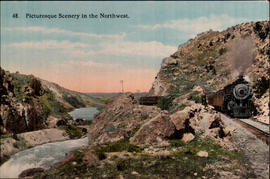
The Southern Pacific Railroad's Shasta Line from Portland to San Francisco, and the Coast Line from Los Angeles to San Francisco were together known as the "Road of a Thousand Wonders.". circa 1920.
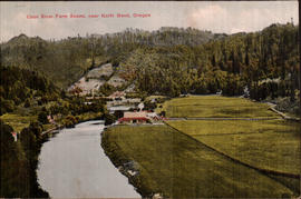
The Coos River is approximately 60 miles long, in southwest Oregon. It rises in western Douglas County, in the mountains west of Roseburg. It flows generally west through the mountains, entering the eastern end of Coos Bay on the Pacific, near the town of Coos Bay. It rises in western Douglas County, in the mountains west of Roseburg. It flows generally west through the mountains, entering the eastern end of Coos Bay on the Pacific, near the town of Coos Bay. circa 1911.
Printed on front: Coos River Farm Scene, near North Bend, Oregon
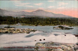
Scientists believe that about 1,000 years ago, a giant landslide from the north shore of the Columbia River blocked the Gorge and stopped the river's flow. This natural dam created an inland sea in eastern Oregon, Washington, and into Idaho. Over time, water eroded the dam and created an awesome natural stone bridge. Eventually, this bridge fell, creating the Cascade rapids. Native American legend also speaks of the creation and destruction of this natural bridge. circa 1930.
Printed on front: Cascades of the Columbia River, sight of the fabled, "Bridge of the Gods."
Printed on back: Columbia River is one of the big waterways of the world. Rising in the Selkirk Mountains of British Columbia, it flows through the states of Washington and Oregon, draining an immense area. The matchless scenery along its entire length is wild and imposing, reaching the climax of picturesque grandeur when it cuts the Cascade Mountain Range, forming what is known as the Columbia River Gorge, a veritable wonderland. Towering peaks, pinnacles, cathedral shaped rocks and innumerable water falls line both shores for many miles, making it the mecca of all tourists.
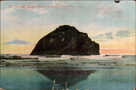
Now called Face Rock, rather than The Sphinx--Local legend says that Face Rock is the face of an Indian maiden that was frozen into stone by an evil spirit. The Cat and Kittens Rock nearby are her animals that were thrown into the sea and turned to stone by the same evil spirit. Her anger is so great she refuses to look at him, so her face remains resolutely turned towards the sky. circa 1910.
Printed on front: The Sphinx, Bandon Beach, Oregon.
Message: Hare Curry Co. Oregon. Dear Mrs. Crosson I thank you very much for the nice Easter Card you sent me and was so glad to hear from you all. How is everyone? I wish you could be here and go with me to gather wildflowers. They are just beautiful weather fine Come and see us Your sincere friend Best wishes to all. Andy is back, isn't he? Rachel Morrill
Addressee: Mrs. J. V. Crosson Aberdeen, Wash. 700 West Herme St.
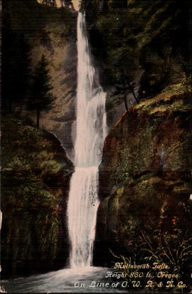
Plummeting 620 feet from its origins on Larch Mountain, Multnomah Falls is the second highest year-round waterfall in the United States. The Oregon-Washington Railroad & Navigation Company was incorporated in Oregon in late 1910. Union Pacific was the parent company, and over time the O.W.R. & N. Co. just became known as the Union Pacific. circa 1920.
Printed on front: Multnomah Falls, Height 860 ft., Oregon. On line of O.W. R. & N. Co.
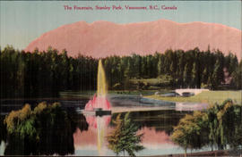
In 1886, Vancouver B.C.'s first City Council dedicated the 1,000 acre peninsula for park and recreation purposes. On September 27, 1887 Stanley Park was officially opened, establishing the fledgling city's first official "greenspace". The park was named for Lord Stanley, Governor General of Canada. circa 1936.
Printed on front: The Fountain, Stanley Park, Vancouver, B.C., Canada
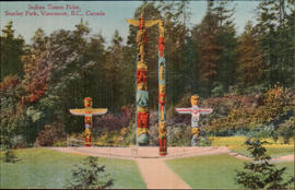
The totem pole display area at Brockton Point is the most visited tourist attraction in all of British Columbia. The initial four poles, all from the Alert Bay region on Vancouver Island, were purchased by the Park Board in conjunction with the Art, Historical and Scientific Society (precursor to the Vancouver Museum). Totem pole numbers increased as the City prepared for its Golden Jubilee Celebration in 1936. The totem poles were moved from their original location at Lumberman's Arch in the early 1960's. circa 1930.
Printed on front: Indian Totem Poles, Stanley Park, Vancouver, B.C., Canada
Message: Sunday, 5/21/11 Dear Friends, This is a beautiful day here and Lee and I were up and on our horses at 7 o'clock, it was a fine ride we had up and down the mountains. There home certainly is a pretty one but its hard to reach. Regards to the family and to the boys-Andy
Addressee: Miss Myrtle Crosson. 578 W. Wishkah St. Aberdeen, Wash.
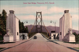
Lions' Gate Bridge, officially known as the First Narrows Bridge, is a suspension bridge that crosses the first narrows of Burrard Inlet and connects the City of Vancouver, British Columbia, to the North Shore municipalities of the District of North Vancouver, the City of North Vancouver, and West Vancouver. The term "Lions' Gate" is in reference to the Lions, a pair of mountain peaks north of Vancouver. The bridge opened to traffic on November 14, 1938. circa 1938.
Printed on front: Lions Gate Bridge, Vancouver, B.C., Canada
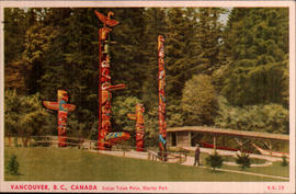
The totem pole display area at Brockton Point in Stanley Park is the most visited tourist attraction in all of British Columbia. Several of the original poles had been carved as early as the late 1880s but time plus the elements took their toll over the ensuing decades. The Skedans Mortuary Pole was replaced in 1962 by a replica with all remaining totems being sent to various museums for future preservation and new ones commissioned or loaned to the Park Board between 1986 and 1992. circa 1950.
Printed on front: Vancouver, B.C., Canada Indian Totem Poles, Stanley Park
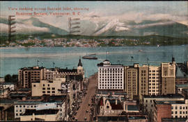
Burrard Inlet lies between the city of Vancouver and the north shore municipalities of West Vancouver and North Vancouver in British Columbia, Canada. circa 1917.
Printed on front: View looking across Burrard Inlet, showing Business Section. Vancouver, B. C.
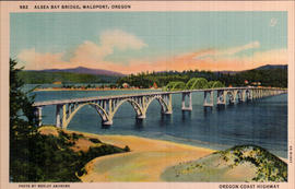
The Alsea Bay Bridge, connecting Waldport with the northern part of Lincoln County on US 101, was originally built using sand taken from the bay. This sand has a high salt content and over the years, the bridge became unsafe. It was demolished, and a new bridge at the same site opened in 1991. circa 1936.
Printed on front: Alsea Bay Bridge, Waldport, Oregon Oregon Coast Highway
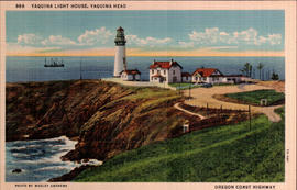
The 93 foot tower of the Yaquina Lighthouse is located on a narrow point of land jutting due west into the Pacific Ocean north of Newport, at Yaquina Head Outstanding Natural Area. Built in 1872, it has been lit since 1873--although the original wicks have been replaced with a 1,000 watt globe. It took approximately one year, and over 370,000 bricks to construct Oregon's tallest lighthouse. Just south of the lighthouse are tide pools where seaweeds, sea stars, hermit crabs, purple urchins, and anemones can be seen. circa 1937.
Printed on front: Yaquina Light House, Yaquina Head Oregon Coast Highway
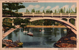
Depoe Bay is a city in Lincoln County, Oregon--in the central coast area. The Kuckenberg-Wittman Company of Portland built this single span reinforced concrete deck arch at the mouth of Depoe Bay in 1927. A stairwell on the bay side and a walkway at the north end of the bridge provide access to Depoe Bay State Park. The bridge is 312 feet in length, and the main span is a 150-foot rib deck arch with an open spandrel. The capacity of the bridge was increased in 1940, when an addition was made on the seaward side of the bridge. circa 1937.
Printed on front: Depoe Bay and Bridge, Depoe Bay, Oregon Oregon Coast Highway
Printed on back: Depoe Bay and Bridge Unusually sheltered and peaceful bay with narrow walled channel outlet to ocean and well adapted as a harbor for deep sea fishing boats. Many interesting specimens of sea life are brought into this port and may be seen living in the aquarium at the end of the bridge--a beautiful concrete arch span overlooking both the bay and the sea.
Message: July 28, 1917 Tomorrow we are going to start for home we had a fine time-Saw all the sights around here wish you could have been with us. Aunt Bertha
Addressee: Master Howard Philbrick Hoquiam Washington 610 Sixth St.