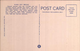
Printed on back: Alsea Bay Bridge Channel spanned with one 210-foot and two 154-foot conctere through tied arches. The north and south approaches to consist of 150-foot concrete deck arches. The north approach lands on a state park. Total length of structure, 3,028 feet, a little over half a mile. Roadway 24 feet wide, with two 3 1/2-foot sidewalks.
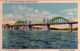
The Siuslaw River Bridge is a bascule bridge that spans the Siuslaw River on U.S. Route 101 in Florence, Oregon. It was designed by Conde McCullough, built by the Mercer-Fraser Company of Eureka, California, and funded by the Federal Emergency Administration of Public Works (later renamed the Public Works Administration). It opened in 1936. circa 1936.
Printed on front: Siuslaw River Bridge, Florence, Oregon Oregon Coast Highway
Printed on back: Siuslaw River Bridge The channel is spanned by a double leaf steel bascule draw span with a clear distance of 140 feet between piers and two 154-foot concrete through tied arches. North and south approaches consist of concrete viaduct landing on state parks. Total length of structure, 1,650 feet, about one-third mile. Road 27 feet wide with two 3 1/2 foot sidewalks.
This neighborhood was named in honor of CPR (Canadian Pacific Railroad) president Sir Thomas Shaughnessy. Its principal streets bear the names of his daughter, Marguerite, and several early members of the company board of directors: Angus, Marpole, Hosmer, Osler and Nanton. By 1914 there were 243 households in Shaughnessy Heights, 80 per cent of which were listed in the Vancouver social register. This particular house, known as the Hycroft, was designed by Thomas Hooper, a renowned Western Canadian. It built for Alexander Duncan McRae, a leading businessman and politician in Western Canada at the beginning of the twentieth century. The McRaes gave it to the government for $1.00 in 1942. It was then used as as a convalescent hospital for war veterans until 1960. In June 1962 the University Women's Club of Vancouver acquired it and they still own and maintain the mansion. circa 1917.
Printed on front: Residential View on Shaughnessy Heights. Vancouver, B.C.
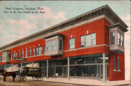
Hoquiam was officially incorporated on May 21, 1890. Its name is taken from a Native-American language meaning "Hungry for wood". The logging and lumber business peaked during the late 1920s, although the area has continuing lumber industry ties. The Logger's PlayDay is an annual event held every September, featuring a parade, and tree-topping, log rolling, ax-throwing and choker-setting competitions. circa 1910.
Printed on front: Hotel Grayport, Hoquiam, Wash. One of the best Hotels in the State.
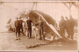
Men standing around and on a very large whale in Cosmopolis, Washington. Cosmopolis is a small city in Grays Harbor County. The Chehalis River runs parallel to the main drag, and the area is well known for its sturgeon fishing and its ties to the lumber industry. circa 1912.
Printed on front: A 60 Ton Humpback Whale 60 foot long, 45 foot around.
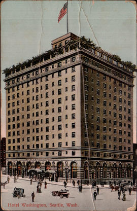
This view is actually of the New Washington Hotel, at the corner of Second and Stewart. The hotel was developer James Moore's response to losing his Gothic landmark, the original Washington Hotel, to the Denny regrade. (His namesake Moore Theatre is directly behind the hotel.) The New Washington opened in 1908, was purchased by the Catholic church as a retirement home in 1963, added to the National Historic Register and given local Landmark status in 1989--and was turned into low income housing in 1990. It is now called the Josephinum/New Washington Hotel. circa 1910.
Printed on front: Hotel Washington, Seattle, Wash.
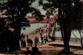
Stanley Park, in Vancouver, British Columbia, Canada. In the 1860's, the area was used as a military reserve before being designated as a park in 1886 by the Dominion of Canada. The park was named after Lord Stanley, Governor General of Canada. Today the park covers over 1,000 acres, and is the third largest city-owned park in North America. circa 1912.
Printed on front: View from Stanley Park, Vancouver, B.C.
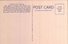
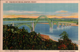
Printed on back: Yaquina Bay Bridge The channel is spanned woth 600-foot steel through arch and two 350-foot steel deck arches. The north and south plazas are each 51 feet long and rise from city and state parks. Total length of structure, 3, 260 feet, about 5/8 mile. The roadway is 27 feet wide with two 3 1/2 foot sidewalks. Main piers are carried 50 feet below zero tide level.
The Yaquina Bay Bridge is an arch bridge that spans Yaquina Bay south of Newport, Oregon. The bridge opened on September 6, 1936, at a cost of $1,301,016. A total of 220 people worked to pour 30,000 cubic yards of concrete and fabricate 3,100 tons of steel. circa 1936.
Printed on front: Yaquina Bay Bridge, Newport, Oregon Oregon Coast Highway
Message: 4-21-12 Dear friend; I received your card yesterday and was very much surprised and sorry to hear that Mother was in hospital. I hope it is nothing serious and that she will soon be home with you all again. Just tell her I send her my full sympathy and hope for her speedy recovery. Love to all the family-Andy.
Addressee: Miss Myrtle Crosson 518 W. Wishkah St. Aberdeen, Wash.
Although first settled earlier, Moclips was not established until 1905 with the completion of the Northern Pacific railroad and the first Moclips Beach Hotel. Although the caption reads "Point Granville", the photo was probably taken at Point Grenville, an area northwest of Moclips named in 1792 by Captain George Vancouver after British Secretary of State William Grenville. circa 1908.
Printed on front: Point Granville, near Moclips, Wash.
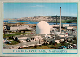
In January 1943, Hanford was chosen by the Federal government as the site for the world�s first full-scale plutonium production plants. It was considered an ideal place because of the remote location, the access to railroad systems, the proximity to the Columbia River needed for cooling the reactors, and the abundance of hydroelectric power generated from dams along the river. The Hanford 300 Area was constructed and operated as a reactor fuel fabrication and laboratory complex. circa 1970.
Printed on back: Hanford Works U.S. Atomic Energy Commission Reservation This atomic energy installation is a major testing center for the nation's top priority energy programs.
Message: Dear Candy--It is so very hot here stays so in the room all the time so far-Back is much better am just going out for some breakfast-It is nearly noon. May ? today- hope it's cooler up there. Love to all, Connie
Addressee: Mrs. Herb Irving Aberdeen Ave. Hoquiam, Wash.
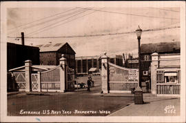
One of the entrance gates at Puget Sound Naval Shipyard, as it looked a few weeks prior to the bombing of Pearl Harbor. Puget Sound Naval Shipyard and Intermediate Maintenance Facility is a United States Navy shipyard covering approximately 180 acres on the Puget Sound in Bremerton. Historically it has been known as Navy Yard Puget Sound, Bremerton Navy Yard, and Puget Sound Naval Shipyard, and as part of Naval Base Kitsap. It is bordered on the south by Sinclair Inlet, on the west by the Bremerton Annex of Naval Base Kitsap, and on the north and east by the city of Bremerton. It is a major employer of the region. circa 1941.
Printed on front: Entrance-U.S.Navy Yard-Bremerton-Wash.
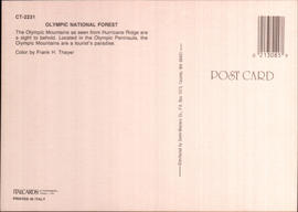
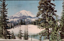
Printed on back: Olympic National Forest The Olympic Mountains as seen from Hurricane Ridge are a sight to behold. Located in the Olympic Peninsula, the Olympic Mountains are a tourist's paradise.