Showing 824 results

Collections
Aerial Photography Image With digital objects
Advanced search options
Print preview View:

D53468-8

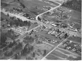
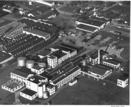
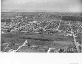
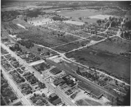
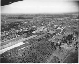
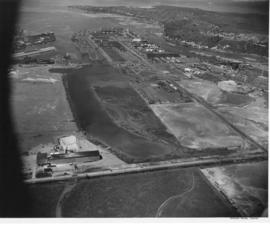
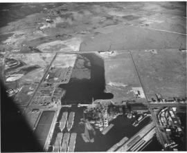
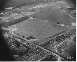
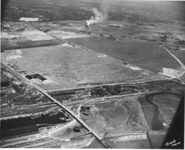
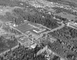
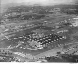
Scenic views from Eastern Washington. An aerial view of farm land, a sprawling building in the center, a plant in the upper right with what may be a Ralston Purina logo painted on a tower, and a small residential community in the upper left in one of the broad valleys of eastern Washington. A narrow river meanders through the foreground.


Land; Valleys--Washington; Rivers; Industrial facilities;

A53195-12

ca. 1950. Aerial view of South Tacoma Way at Steilacoom Blvd. was taken probably in the fall of 1950. This was near South 96th-100th Streets. Although the area is starting to become developed, there is still a lot of vacant land available.


Aerial photographs; Land--Tacoma--1950-1960; Commercial streets--Tacoma--1950-1960;

A53195-3

ca. 1950. Aerial view of landscape close to Steilacoom Blvd. was taken probably in the fall of 1950. The area was slowly developing; however, there was still much room for expansion. Developers did manage to leave much of the tall foliage around the homes.


Aerial photographs; Neighborhoods--Lakewood--1950-1960; Land use--Lakewood--1950-1960;

A53195-4

ca. 1950. It appears that a number of aerial photographs of the Lakewood area were taken in the fall of 1950. The area was slowly growing and developing; this particular neighborhood seems to be of mixed usage with businesses and homes scattered among the tall trees.


Aerial photographs; Neighborhoods--Lakewood--1950-1960; Land use--Lakewood--1950-1960;

A53173-1

ca. 1950. Aerial view of Annie Wright Seminary, from Tacoma Ave. No. to Commencement Bay in the North end of Tacoma. The heavily wooded area between the school and the Stadium district is Garfield Park. Annie Wright Seminary was endowed by Northern Pacific Railroad's President C. B. Wright, with an original grant of $50,000. The school was named for his daughter Annie. It opened in 1884 with 94 students, at its original location of 611 Division Ave. It was moved to this location in 1924.


Annie Wright Seminary (Tacoma)--1950-1960; Private schools--Tacoma; Aerial photographs; Annie Wright Seminary (Tacoma)--Buildings

A53024-1

Aerial view, 1000 foot elevation, of Sumner manufacturing division of Fleischmann's Yeast taken in September, 1950. Photograph taken at 5 p.m.; evening shadows start to creep over the large plant. Fleischmann's Yeast was part of Standard Brands, Inc., and is still sold in grocery stores today. Photograph ordered by Standard Brands' New York City office.


Fleischmann's Yeast (Sumner); Standard Brands, Inc. (Sumner); Aerial photographs;

A80571-1

Blair Bridge over the Port Industrial Waterway in the closed position, photographs ordered by State Highway Department. The bridge opened in November of 1953. It was a lift bridge structure, a double leaf Bascule span. There was a 150 foot channel between the main piers for the passage of shipping vessels. The bridge was constructed for a cost of $1,600,000. (TNT 11/13/1953, section D)


Port of Tacoma (Tacoma)--1950-1960; Aerial photographs; Harbors--Tacoma; Port Industrial Waterway Bridge (Tacoma); Vertical lift bridges; Bridges--Tacoma; Blair Bridge (Tacoma);

A80571-6

Blair (Port Industrial Waterway) Bridge in the open position, for the State Highway Department. The bridge opened for traffic in November of 1953, cutting commuting time in the Tideflats. It is a lift bridge with a 150 foot channel between the main piers for the passage of shipping vessels. The two main channel piers house the operating machinery for opening and closing the span drawbridge. They are the equivalent in height, measured above and below the water, to a seven story building. (TNT 11/13/1953, Section D)


Port of Tacoma (Tacoma)--1950-1960; Aerial photographs; Harbors--Tacoma; Port Industrial Waterway Bridge (Tacoma); Vertical lift bridges; Bridges--Tacoma; Blair Bridge (Tacoma);

D81185-A

Aerial view of Tacoma industrial Tideflats in 1954 with major focus on the Port Industrial Waterway. Mothballed WWII flattops are positioned close to the U.S. Naval Station. A collection of log booms are amassed in the Sitcum Waterway. The tip of Mount Rainier can be spotted at the top of the photograph.


Aerial photographs; Port of Tacoma (Tacoma)--1950-1960; Sitcum Waterway (Tacoma); Port Industrial Waterway (Tacoma); Logs; Rainier, Mount (Wash.);

D81185-4

Aerials of the Port of Tacoma, circa 1954, with Mount Rainier in the background. From left to right lies the U.S. Naval Station with the mothballed fleet of flattops, kept in readiness, on the Port Industrial Waterway. The fingertip piers of the Port of Tacoma can also be seen on the Industrial Waterway. The Port of Tacoma grain elevators lie at the tip of land facing the Sitcum Waterway. The large, almost rectangular Sitcum Waterway holds many log booms. Tacoma Boat Building's tall sheds for drydock can be seen on the other side of the waterway. The smaller Milwaukee Waterway separates the Henry D. Gee Co. Grain Storage and the Puget Sound Freight Lines. TPL-2255


Aerial views; Port of Tacoma (Tacoma)--1950-1960; Rainier, Mount (Wash.); Port Industrial Waterway (Tacoma); Sitcum Waterway (Tacoma);

A102546-4

Aerial of the Port of Tacoma, taken from over Commencement Bay heading into the Port. Tacoma can be seen as the forested area on the right dotted with buildings, with the Tideflats laying to the left of the bridge shrouded densely with industrial smoke.


Aerial views; Port of Tacoma (Tacoma)--1950-1960;

A72491-1

ca. 1953. An undated aerial photograph of the industrial Tacoma Tideflats area shows a majestic view of snow-capped Mount Rainier looming in the background. Shaffer Terminals are on the right hand side of City Waterway; the waterway is now known as the Thea Foss Waterway. Shell Oil facilities are probably across from Shaffer's.


Aerial photographs; Rainier, Mount (Wash.); Waterfronts;

D75872-70

Aerial photographs. Photographs taken from an airplane in June, 1953, show the South Tacoma area as it was back then. Rows of homes and businesses are interspersed with stretches of unoccupied, wooded land. Surprisingly, there is little or no traffic on South 56th St., believed to be on the extreme right, quite unlike today. Photograph ordered by North Pacific Bank.


Aerial photographs; Neighborhoods--Tacoma--1950-1960;

D75872-79

Aerial photographs. A large number of photographs of the South Tacoma area were taken in one day by airplane on behalf of North Pacific Bank, which was based in that area. Multi-lane road is possibly South Tacoma Way with People's Warehouse on the right and possibly Vaughan Lumber towards the center. S 66th St. intersects towards the center of the photo with South Tacoma Way; Mount Tahoma High School would later be built on the undeveloped land nearby.


Aerial photographs; Neighborhoods--Tacoma--1950-1960;

D75872-59

Aerial photographs. The South Tacoma area in the early 1950's was still vastly undeveloped. Aerial photographs shot on behalf of North Pacific Bank, based in South Tacoma, show large stretches of unoccupied land which remained heavily wooded. The Northern Pacific Railway shops can be seen about the middle of the picture on South 51st & Adams with the South Tacoma Air Park and Tyler Street nearby. TPL-2058


Aerial photographs; Neighborhoods--Tacoma--1950-1960; Northern Pacific Railway Co. (Tacoma);

D75943-12

Aerial view of the Tacoma tideflats and Port of Tacoma. TPL-2251 Lincoln Ave. runs across the front of the photograph, with the Stauffer Chemical plant shown. The body of water in the center of the picture is the Port Industrial Waterway. East 11th Street runs between the waterway and Commencement Bay. The partially completed Port Industrial Waterway bridge can be seen, also the mothballed WWII baby flattops and the Port of Tacoma with its piers 1 & 2. The land curves around the right side of the picture ending in Browns Point.


Aerial views; Port of Tacoma (Tacoma)--1950-1960;

D75943-16

Aerial view of the Tacoma tideflats and Port of Tacoma. High tide. The road about halfway up the picture is East 11th Street as it crosses the Port Industrial Waterway. The partially completed bridge that opened in November of 1953 can be seen. In the left foreground of the picture are the baby flattops constructed for WWII and then stored here after the war. The Port of Tacoma Pier 1 lies to the right. Port of Tacoma Rd. runs from the Port to Lincoln Ave. The city of Tacoma had plans for all of the vacant land. They planned to fill it where needed and sell it to industries that needed deep water ports. TPL-2257


Aerial views; Port of Tacoma (Tacoma)--1950-1960;

D75943-22

Aerial view of the Tacoma tideflats and Port of Tacoma. High tide. Prominent in the picture is the St. Paul and Tacoma Lumber Co. lying to the right of E. 11th Street in the foreground of the picture. Commencement Bay is to the left of 11th St., to the right is almost 1500 acres of vacant industrial land that Tacoma hoped to develop. The Port Industrial Waterway can be seen to the left rear of the picture. The city wanted to dredge this body of water for a deep water channel and collect premium prices for the vacant 1 1/2 miles of land lying beside it.


Aerial views; Port of Tacoma (Tacoma)--1950-1960;

D75943-4

Aerial photographs of the Port of Tacoma at low tide. The body of water in the foreground of the picture with the log booms is the Puyallup Waterway. The following body of water is the Milwaukee Waterway. The road with the bridge is East 11th Street. Milwaukee Way runs at a right angle from 11th and crosses Lincoln Ave. The inland area beyond this point is mostly vacant with some scattered industries. Tacoma hoped to develop this 1500 acres into prime industrial area.


Aerial views; Port of Tacoma (Tacoma)--1950-1960;

D77321-7

Aerial of downtown Tacoma looking west from the Eleventh Street Bridge. The bridge crosses the City Waterway and provides transportation from the commercial downtown area to the industrial area.


Aerial photographs--1950-1960; Business districts--Tacoma--1950-1960;

D77321-2

Aerial of downtown Tacoma looking west up 11th Street from the Eleventh Street Bridge, taken on August 18, 1953.


Aerial photographs--1950-1960; Business districts--Tacoma--1950-1960; 11th Street Bridge (Tacoma); Bridges--Tacoma--1950-1960; Commercial streets--Tacoma--1950-1960;

D150975-7

Aerial view on February 22, 1967, of City (now Thea Foss) Waterway which separates downtown Tacoma from the industrial Tideflats area. The waterway is partially filled with many log booms. Schoenfeld's massive furniture store can be glimpsed in the left hand corner of photograph. The larger of the two bridges shown is the 15th St. Bridge which is no longer there. Long roadway to the right of waterway is D St. The Museum of Glass would be built across the waterway on Dock St. next to Albers Mill in 2001. Photograph ordered by D Street Rafting Co. TPL-8826


Aerial photographs; City Waterway (Tacoma); Logs;

D150900-356

1967 Richards stock file. An aerial look at the Elks Temple taken on October 28, 1967, shows the home of one of the largest Elks memberships in the world. The new structure was dedicated in September, 1965. Members could enjoy a plethora of activities including fine dining, sports, and dancing. To the left is the Allenmore Medical Center, 1901 So. Union, which also opened in 1965.


Aerial photographs; Elks Temple (Tacoma); Benevolent and Protective Order of Elks, Tacoma Lodge No. 174 (Tacoma); Parking lots--Tacoma--1960-1970; Allenmore Medical Center (Tacoma);

D150900-354

1967 Richards stock file. Closer aerial view on October 28, 1967, of the new University Village Shopping Center located in University Place around 40th & Bridgeport Way. A large parking lot would provide adequate parking for the customers of Food King supermarket and Don's Village Drugs. The shopping center opened in October, 1967. It was surrounded by large wooded lots. The 400,000 gallon University Place water tower is on W. 40th between Bridgeport and Anderson.


Aerial photographs; Neighborhoods--University Place; Shopping centers--University Place; Food King (University Place); Water towers--University Place;

D150900-230

1967 Richards stock footage. Aerial view of Tidewater Oil Co. plant on the Tacoma industrial tideflats taken in mid-June, 1967. A similar photograph was taken the year before in June, 1966; one noticeable difference is the large Flying A symbol on a storage tank has been replaced by a Phillips 66 logo. Phillips Petroleum had bought out the Flying A service stations on the west coast in 1966.


Aerial photographs; Tidewater Oil Co. (Tacoma); Industrial facilities--Tacoma--1960-1970; Storage tanks--Tacoma;

D151531-18C

This aerial view of the Port of Tacoma's Pier 7 with its new Kaiser Dome, crane, and extended dock was taken on April 28, 1967. The extension of the pier meant that foreign as well as American ships could dock to load logs, (log dumps shown both in the waterway and on land), general cargo and military goods. The massive crane was able to reach completely over a conventional ship and had a 40-ton capacity 100-feet from the dock. It played a major role in transferring alumina ore from visiting Australian cargo ships to the Port's new dome-shaped storage and load-out building. The dome-shaped storage facility in this photograph and its twin, which was built several years later, were both dismantled in 2005. (Photograph ordered by Kaiser Engineers.) (TNT 2-15-67, A-1, TNT 2-26-67, B-11)


Aerial photographs; Kaiser Aluminum & Chemical Corp. (Tacoma); Storage tanks--Tacoma; Hoisting machinery; Piers & wharves--Tacoma--1960-1970; Logs;

D151531-19

April, 1967, aerial view of Tacoma Tideflats, featuring Port of Tacoma's Pier 7 with new Kaiser Dome, huge crane, expanded dock and log dumps. This was one of the Port's major projects designed to produce more business. The aluminum-sheathed storage dome would hold 50,000 tons of alumina used for the production of aluminum for Kaiser Aluminum, under contract with the Port. The massive crane was designed and built to the Port's specifications in Japan but assembled here; it was the only one of its kind. Furthermore, extension of the pier meant that more foreign and American ships could dock to load and unload bulk cargo, including logs and military goods. Photograph ordered by Kaiser Engineers. (TNT 2-15-67, A-1, TNT 2-26-67, B-11)


Aerial photographs; Storage tanks--Tacoma; Hoisting machinery; Kaiser Aluminum & Chemical Corp. (Tacoma); Piers & wharves--Tacoma--1960-1970; Logs;

D152628-1C

February 24, 1969, aerial view of Holiday Inn, Fife. The large hotel, 3518 Pacific Hwy. E., was located on Pacific Hwy. across the street from Buck & Son Tractor. It provided plenty of parking for its guests and a rectangular swimming pool nestled between the hotel buildings. Swimmers and those relaxing under the table umbrellas could experience a sense of privacy from busy highway traffic. A large grassy area was available for guests - and small children - to stretch their legs. Photograph ordered by Sherwood & Roberts, Inc.


Aerial photographs; Holiday Inn (Fife); Hotels--Fife;

D152626-6C

Aerial view of new rod mill at Kaiser Aluminum on February 24, 1969. Smoke billows from the new 500-foot stack. Kaiser's new aluminum rod mill began operations in December, 1968. Photograph ordered by Kaiser Engineers, Inc.


Aerial photographs; Kaiser Aluminum & Chemical Corp. (Tacoma); Industrial facilities--Tacoma--1960-1970; Aluminum industry--Tacoma--1960-1970;

C152548-1

ca. 1967. Copy of aerial print of Puget Sound region featuring major and projected freeways, ca. 1967. Seattle-Tacoma Airport's proximity to an anticipated Multi-Purpose Stadium is noted. Freeways are labeled and locations accentuated by white lines. Pierce County residents would be asked to support a $10 million bond that would assist King County in building a sports stadium should a site be chosen south of the airport. Photograph ordered by advertising agency Bozell & Jacobs on October 30, 1967. (TNT 10-31-67, p. 1)


Aerial photographs; Express highways--Wash.;

Results 31 to 60 of 824