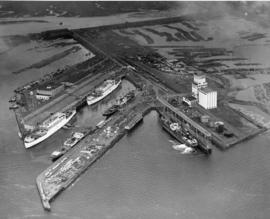
This aerial view, taken January 13, 1940, shows the Port of Tacoma piers with two docked, white transport ships. Three transport ships, the Hunter Liggett, Leonard Wood and St. Mihiel, were in Commencement Bay to transport over 7,500 soldiers from Fort Lewis to the biggest war games in US history. This is the biggest passenger embarkation in the history of the Tacoma port. The troops will invade the California coast from the sea. They will strike at an undisclosed location somewhere on the 400 mile coast between San Francisco and Santa Barbara. This will be the major offensive of the war games to be held January 15-22nd. Also in the photograph are the Co-op's white grain elevators; the waterway is crowded with log booms. The two other cargo vessels pictured are believed to be the South American freighter Coya and the Japanese freighter Koei Maru. ( T. Times 1-3-40, p. 1-article; 1-11-40, p.1-article; 1-13-40, p.1-article)
Aerial photographs; Bays--Washington (State); Commencement Bay (Wash.); Port of Tacoma (Tacoma)--1940-1950; Logs; Ships; Piers & wharves--Tacoma--1940-1950;
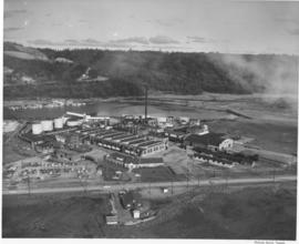
An aerial photograph of the sprawling Pennsylvania Salt Manufacturing Co. of Washington was taken in October, 1954. The Tacoma plant, whose parent company was founded over one hundred years ago in Natrona, Pennsylvania, has been at its 40 acre Tideflats location on the Hylebos waterway since 1929. Throughout the years, it has undergone rapid expansion of its facilities and also its product lines. Despite its name, it has no connection with the manufacture of table salt. Photograph ordered by Pennsylvania Salt Manufacturing Co. of Washington.
Aerial photographs; Pennsylvania Salt Manufacturing Co. of Washington (Tacoma); Chemical industry--Tacoma--1950-1960; Hylebos Waterway (Tacoma);
ca. 1939. Associated Oil Company aerial view of Tacoma West End from Day Island to Point Defiance and beyond. Piers for first Narrows Bridge under construction. Ordered by George Martinac, North Pacific Bank Note.
ca. 1939. Associated Oil Company aerial view of Tacoma, West End to Downtown, tideflats and beyond. Piers for first Narrows Bridge under construction. Ordered by George Martinac, North Pacific Bank Note.
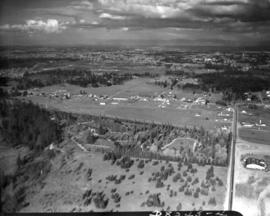
Associated Oil Company aerial view looking south toward Lakewood. Cemetery and highway in foreground. Ordered by George Martinac, North Pacific Bank Note Company.
ca. 1939. Associated Oil Company aerial view of Tacoma West End showing area above Titlow Beach and Day Island. Photograph taken circa 1939. Ordered by George Martinac, North Pacific Bank Note Company.
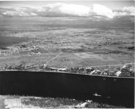
Associated Oil Company aerial view of Northeast Tacoma, Vashon Island, and Commencement Bay. Ordered by George Martinac, North Pacific Bank Note Company.
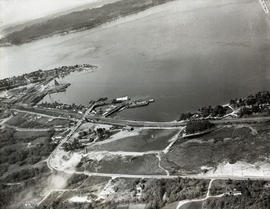
ca. 1939. Associated Oil Company aerial view of west side cement plant and construction of west pier for first Narrows Bridge. Ordered by George Martinac, North Pacific Bank Note. TPL-6712
Associated Oil Company aerial view of west side cement plant and construction of west pier for first Narrows Bridge. Ordered by George Martinac, North Pacific Bank Note.
ca. 1939. Associated Oil Company aerial view of west side cement plant for first Narrows Bridge construction. Ordered by George Martinac, North Pacific Bank Note.
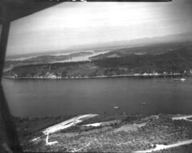
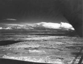
ca. 1939. Aerial view from the Narrows of Tacoma's West End with downtown and the Tideflats beyond. Running down the center of the photograph is Sixth Ave. as it veers off to Titlow Beach in the lower right hand. It is crossed by Pearl Street, where the excavation for (what is believed to be) a planned Tacoma airport forms a pattern on the ground. The area is largely undeveloped. Construction on the Narrows Bridge (Galloping Gertie) had begun but was far from completion. For a 1961 aerial view of the same location, see D129800, images 43 & 131. TPL-9156
Aerial view of Tacoma industrial Tideflats in 1954 with major focus on the Port Industrial Waterway. Mothballed WWII flattops are positioned close to the U.S. Naval Station. A collection of log booms are amassed in the Sitcum Waterway. The tip of Mount Rainier can be spotted at the top of the photograph.
Aerial photographs; Port of Tacoma (Tacoma)--1950-1960; Sitcum Waterway (Tacoma); Port Industrial Waterway (Tacoma); Logs; Rainier, Mount (Wash.);
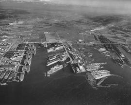
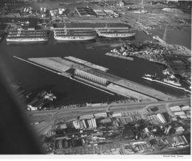
Aerials of the Port of Tacoma, c. 1954. The Port Industrial Waterway takes up most of the photograph with the mothballed WWII flattops stored in readiness for combat activation next to the U.S. Naval Station. The round storage tanks at Hooker Electrochemical can be seen behind the fleet of ships. The Port of Tacoma fingertip piers lie along the other side of the Waterway. The round storage tanks of Time Oil Co. and the Port of Tacoma Grain Elevators occupy the tip of land jutting out between the Port Industrial Waterway and the Sitcum Waterway. TPL-2250
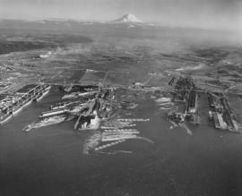
Aerials of the Port of Tacoma, circa 1954, with Mount Rainier in the background. From left to right lies the U.S. Naval Station with the mothballed fleet of flattops, kept in readiness, on the Port Industrial Waterway. The fingertip piers of the Port of Tacoma can also be seen on the Industrial Waterway. The Port of Tacoma grain elevators lie at the tip of land facing the Sitcum Waterway. The large, almost rectangular Sitcum Waterway holds many log booms. Tacoma Boat Building's tall sheds for drydock can be seen on the other side of the waterway. The smaller Milwaukee Waterway separates the Henry D. Gee Co. Grain Storage and the Puget Sound Freight Lines. TPL-2255
Aerial views; Port of Tacoma (Tacoma)--1950-1960; Rainier, Mount (Wash.); Port Industrial Waterway (Tacoma); Sitcum Waterway (Tacoma);
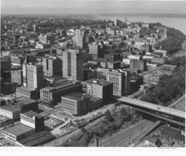
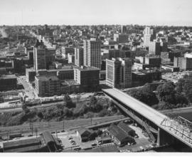
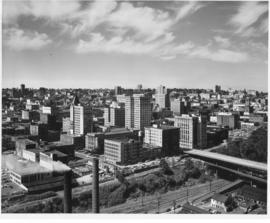
Aerial of downtown Tacoma looking west from the Eleventh Street Bridge. The bridge crosses the City Waterway and provides transportation from the commercial downtown area to the industrial area.
Aerial photographs--1950-1960; Business districts--Tacoma--1950-1960;
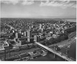
Aerial of downtown Tacoma looking west from the Eleventh Street Bridge. The Dock Street Steam Plant can be seen at lower left. Railroad tracks and a green belt divide the commercial downtown area from the waterfront. The bridge crosses over the City Waterway into the industrial area.
Aerial photographs--1950-1960; Business districts--Tacoma--1950-1960;
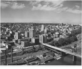
Aerial of downtown Tacoma looking west from the intersection of 11th & A Streets. The Dock Street Steam Plant can be seen in the left hand foreground and the Eleventh Street Bridge on the right. The Eleventh Street Bridge crosses the City Waterway and leads to the Tideflats and Port of Tacoma industrial areas.
Aerial photographs--1950-1960; Business districts--Tacoma--1950-1960; 11th Street Bridge (Tacoma); Commercial streets--Tacoma--1950-1960;
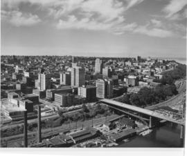
This is an aerial of downtown Tacoma looking west from 11th and A street as it appeared in August of 1953. Beginning span of the 11th Street Bridge at lower right corner and smoke stacks from Dock Street Steam plant at lower left.
Aerial photographs--1950-1960; Business districts--Tacoma--1950-1960; 11th Street Bridge (Tacoma); Bridges--Tacoma--1950-1960; Commercial streets--Tacoma--1950-1960;
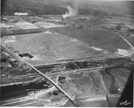
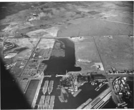
Aerial view of the Tacoma tideflats and Port of Tacoma. TPL-2254. The intersection of Lincoln Ave. (right), Alexander and E. 11th Street (left). Port of Tacoma and Port Industrial Waterway visible. Photograph shows the 1500 acres of vacant land that the city of Tacoma hoped to sell to industries needing a deep water port.
This aerial view of the Tacoma tideflats and Port of Tacoma was taken in July of 1953. At the upper right of center a small fleet of baby flat tops built in Tacoma during World War II are "mothballed" in the Wapato (now Blair) Waterway next to the Tacoma naval station. The Port of Tacoma is to the left of the mothballed ships. Browns Point can be seen in the upper right corner. Commencement Bay can be seen lying beyond the Port. The two streets crossing the tideftats are East Eleventh Street and Lincoln Avenue (in the bottom half of the image). TPL-2259.
Aerial photographs of the Port of Tacoma at low tide. The body of water in the foreground of the picture with the log booms is the Puyallup Waterway. The following body of water is the Milwaukee Waterway. The road with the bridge is East 11th Street. Milwaukee Way runs at a right angle from 11th and crosses Lincoln Ave. The inland area beyond this point is mostly vacant with some scattered industries. Tacoma hoped to develop this 1500 acres into prime industrial area.
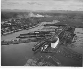
Baby flat tops built in Tacoma during World War II are "mothballed" along the Port of Tacoma waterfront following the war alongside the Naval Storage area. Hooker Electrochemical Co. lies behind the Naval area (see the circular tanks.) The Port of Tacoma is in the front of the picture with its "finger pier." The partially completed Port Industrial Waterway bridge can be seen on the right hand side next to the flattops. TPL-2253.
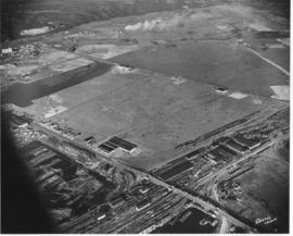
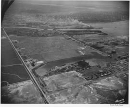
Aerial view of the Tacoma tideflats and Port of Tacoma. High tide. Prominent in the picture is the St. Paul and Tacoma Lumber Co. lying to the right of E. 11th Street in the foreground of the picture. Commencement Bay is to the left of 11th St., to the right is almost 1500 acres of vacant industrial land that Tacoma hoped to develop. The Port Industrial Waterway can be seen to the left rear of the picture. The city wanted to dredge this body of water for a deep water channel and collect premium prices for the vacant 1 1/2 miles of land lying beside it.
Aerial photographs of the Port of Tacoma at low tide. The body of water is the Port Industrial Waterway, which was being promoted as a future deep water channel. The land lying to the right of the waterway was 1 1/2 miles of industrial land with deepwater access. The road in front of the waterway is East 11th Street, to the right is the Port of Tacoma Road and to the rear is Lincoln Ave. The area behind Lincoln Ave. was scheduled to be filled with the dirt dredged from the waterway and then sold to industries. Stauffer Chemical can be seen on Lincoln Ave. (2545 Lincoln Ave.) The partially completed Port Industrial Waterway bridge can be seen in the foreground of the picture.
Aerial view of the Tacoma tideflats and Port of Tacoma. High tide. The road about halfway up the picture is East 11th Street as it crosses the Port Industrial Waterway. The partially completed bridge that opened in November of 1953 can be seen. In the left foreground of the picture are the baby flattops constructed for WWII and then stored here after the war. The Port of Tacoma Pier 1 lies to the right. Port of Tacoma Rd. runs from the Port to Lincoln Ave. The city of Tacoma had plans for all of the vacant land. They planned to fill it where needed and sell it to industries that needed deep water ports. TPL-2257
Aerial view of the Tacoma tideflats and Port of Tacoma. Lincoln Ave. runs up the left hand side of the picture and East 11th Street with its partially completed bridge on the right. The smaller body of water in the foreground is the Port Industrial Waterway, the one in the back is Hylebos Waterway and the large body of water on the right is Commencement Bay. The stored baby flattops and the Port of Tacoma can be seen on the right by the bridge. The vacant area is 1500 acres of vacant industrial land that the city hoped would turn Tacoma into the industrial center of the West.