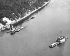
ca. 1939. Associated Oil Company aerial view of west side cement plant and construction of west pier for first Narrows Bridge. Ordered by George Martinac, North Pacific Bank Note. TPL-6712
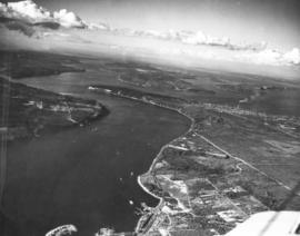
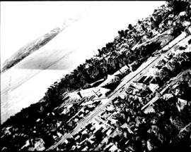
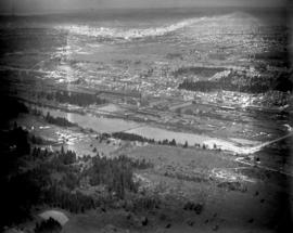
ca. 1939. Associated Oil Company aerial view of Tacoma West End from Day Island to Point Defiance and beyond. Piers for first Narrows Bridge under construction. Ordered by George Martinac, North Pacific Bank Note.
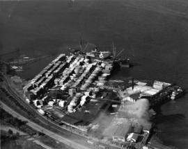
ca. 1938. Dickman Lumber, 2423 Ruston Way. This aerial view, taken circa 1938, shows vast stacks of lumber ready to be loaded onto ships. Dickman Lumber was located just south of the present Old Town dock. It was purchased in 1922 by Leonard Howarth and Ralph L. Dickman, Sr. Dickman Lumber was closed in September of 1977 and its mill destroyed by fire in January of 1979.
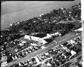
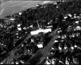
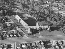
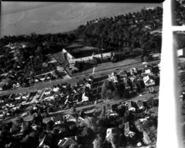
ca. 1938. Aerial view of North End Tacoma showing Annie Wright Seminary, surrounding neighborhood and Commencement Bay. The Tudor Gothic building was built in 1924 on a design by Sutton, Whitney & Dugan.
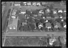
ca. 1935. This is an aerial view of South 43rd and "L" Sts. circa 1935. South "L" runs horizontally in front of the Engine House No. 8 (4301 South "L"). The fire station was built in 1909, replacing the original which had moved to 4102 South "M." Neighboring lots appear small with many trees. BU-2125
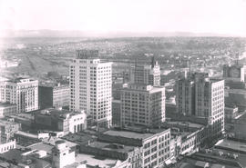
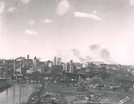
This May, 1931, aerial view of Tacoma's City Center was taken from the industrial Tideflats. The 11th Street Bridge (now Murray Morgan Bridge) is on the right. Jutting into the skyline are (l-r) the Pierce County Courthouse, Puget Sound National Bank, Washington Building, Tacoma Building, and the Art-Deco styled 17-story newly completed Medical Arts Building in the right background. TPL-1788; G91.012
Cityscapes; Aerial views; Aerial photographs; 11th Street Bridge (Tacoma); Pierce County Courthouse (Tacoma); Puget Sound National Bank (Tacoma); Washington Building (Tacoma); Tacoma Building (Tacoma); Medical Arts Building (Tacoma);
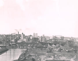
Aerial view looking toward Tacoma's City Center. This May, 1931, view shows many prominent Tacoma landmarks including the Tacoma Building and Perkins Building flanking the 11th Street Bridge (now Murray Morgan Bridge); the newly completed 17-story Medical Arts Building (at center-right); the towering Washington Building at center; Puget Sound National Bank with spire (center-left) and the Pierce County Courthouse with tower in the far left background. TPL-1347; G8.1-021
Cityscapes; Aerial photographs; Aerial views; 11th Street Bridge (Tacoma); Tacoma Building (Tacoma); Medical Arts Building (Tacoma); Washington Building (Tacoma); Puget Sound National Bank (Tacoma); Pierce County Courthouse (Tacoma);
View of Tacoma Tideflats from the top of the Medical Arts Building. The City Waterway can be seen in the background. City Hall, with its distinctive clock tower, is clearly visible. This photograph was taken on April 5, 1931.
Aerial photographs--1930-1940; Cityscapes--1930-1940; City Waterway (Tacoma); Old City Hall (Tacoma);
View of downtown business district of Tacoma looking southeast from the top of the Medical Arts Building as seen on April 5, 1931. Good view of the fronts of the buildings on the east side of Broadway between 9th and 11th.
Aerial photographs--1930-1940; Business districts--Tacoma--1930-1940;
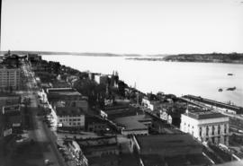
View looking north on Saint Helens St. from the top of the Medical Arts Building on April 5, 1931. Buildings that are clearly visible include the Webster Apartments (629 Saint Helens) and the Elks Temple (565 Broadway- large white building lower right), followed by (right to left) an apartment building (553 Broadway) and the Union Club (539 Broadway.)
Aerial photographs--1930-1940; Cityscapes--1930-1940; Webster Apartments (Tacoma); Elks Temple (Tacoma); Union Club (Tacoma); Commercial streets--Tacoma--1930-1940;
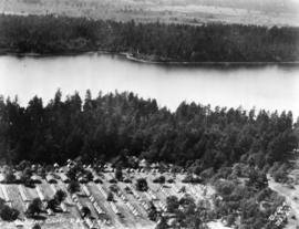
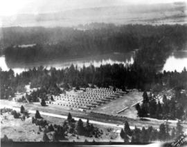
Aerial view of 146th F.A. tents on June 26, 1930. The 146th Field Artillery were participating in the 1930 encampment at Camp Murray. The two-week encampment of the Washington National Guard would last until June 28th. 2600 officers and men, including some 400 Tacomans, would participate in these annual summer maneuvers. Lake in background is American Lake. G77.1-040 (TNT 6-13-30, p. 1-article on encampment)
Aerial photographs; Aerial views; Washington National Guard, 148th F.A. (Tacoma); American Lake (Wash.);
View by air of the 161st Infantry tents at Camp Dent on the grounds of Camp Murray. Camp Dent was the name of the 1930 encampment of the Washington National Guard. Thick stands of trees block the view of American Lake. G69.1-138 TPL-10319
Aerial views; Aerial photographs; Washington National Guard, 161st Infantry (Wash.); American Lake (Wash.);
ca. 1929. Head of Commencement Bay while Sullivan Service at 101 Puyallup Ave. (lower left) was under construction. This aerial view was taken circa 1929. Visible landmarks and streets included: the Union Station at upper left corner; Albers Bros. Milling Co. at upper center (large darker building) ; Northwest Woodenware Co. at center along waterway; Wheeler-Osgood Co.'s saw mill at right center. The Sullivan Service was being built at this time facing Puyallup Ave. at left. Puyallup Ave., which runs horizontally left to right, also had the Independent Paper Stock Co. kitty-corner from Sullivan's at 132 Puyallup Ave. The Washington Gas & Electric Co. was also on the same side of Puyallup Ave. as the Independent Paper Stock Co., at 212-216, and was the large building near right. The street at lower bottom running left to right is South 25th St. E. (photograph torn at left corner)
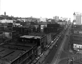
ca. 1928. A Street at So. 11th St., looking north, in 1928. The Tacoma Building, at right center, was completed in 1911. The building was home to the Weyerhaeuser Timber Co. and the Tacoma Commercial Club. It is currently being restored. The Tacoma Hotel can be seen in the background, located where the Frank Russell Co. building stands today.
ca. 1928. Elevated view of 1300 block of Pacific Avenue circa 1928. Among the many businesses on Pacific Avenue were the Owl Cafe at 1336 Pacific (lower left) and the Dillion Bldg at 1330-32 Pacific. The familiar spire of the Puget Sound National Bank is to the far right. The Pierce County Courthouse looms in the distance at far left back with the big white walled Greenwich Coliseum (407 So. 13th St.) below. The Greenwich Coliseum had opened in 1927 and would become a premier athletic venue and ballroom.
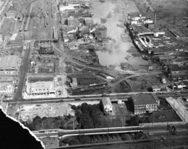
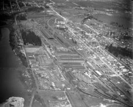
This print from a damaged glass plate negative shows an aerial view of South Tacoma taken in February of 1927. The massive South Tacoma Shops, owned by the Northern Pacific Railway, are located in the center. The plant repaired all Northern Pacific railroad locomotives and cars west of the Mississippi. The shops were composed of 36 separate brick buildings spread out over 15 acres. The grounds were over 1 1/2 miles long, and the work force of 1,250 employees from 20 expert crafts commanded a payroll of $1,500,000 per year. Established in 1890 as Edison Car Shops, the shops closed in 1974. The body of water in the foreground just west of the "shops" was a wetlands area affectionately known to residents of the area as the "South Tacoma Swamp." The road at the right, near the south end of the swamp, is 56th Street. (TNT 02/18/1927, pg. 2)
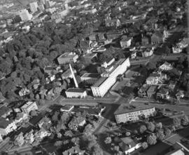
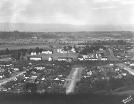
Aerial view of Tacoma's east side and Cushman Hospital. The hospital for veterans is the cluster of buildings in the center of this June, 1926, photograph. Surrounding homes are nestled in wooded lots.
Aerial view taken in February of 1926 of the Northern Pacific shops in South Tacoma. Known as the "South Tacoma Shops," the plant was composed of 36 separate brick buildings, covering 15 acres. Craftsmen from 20 expert fields were employed to build, rebuild and service anything that travelled on wheels for Northern Pacific west of the Mississippi. The plant operated from 1890 until its closure in 1974. The body of water to the left was a wetlands area commonly called the "South Tacoma Swamp." It has since been filled in. (TNT 2/18/1927, pg. 2)
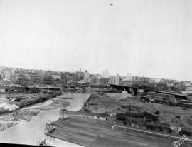
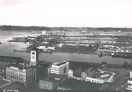
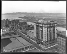
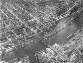
Aerial view of City Center. Although taken in March of 1925, this view of Tacoma's City Center still shows the contrast between its office buildings and other edifices and the (then) relatively undeveloped industrial Tideflats across the waterway. The Pierce County Courthouse with its 230-foot tower can be seen in the distance; closer near the foreground are the Puget Sound National Bank Bldg. with its familiar spire, the nearly completed Washington Building, the smaller Rust Building, and nearest to the 11th St. Bridge (now Murray Morgan Bridge), the Tacoma Building. TPL-1778; G8.1-027A
Aerial views; Aerial photographs; Cityscapes; Office buildings--Tacoma--1920-1930; Pierce County Courthouse (Tacoma); Puget Sound National Bank (Tacoma);
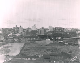
View looking toward the City Center from the Wheeler Osgood plant in March of 1925. Dark smoke blots the spring skies and a few boats float placidly along the City Waterway. There is not much visible traffic on the nearby 11th St. Bridge (now Murray Morgan Bridge.) A similar view is Boland B12169. TPL-1346; G8.1-027B
Aerial views; Aerial photographs; Cityscapes; 11th Street Bridge (Tacoma);
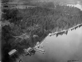
North side of American Lake. This area view was taken by Barnes Aviation Co. in the spring of 1920. The large building on the waters edge at the bottom of the photo is the American Lake Boathouse. Hiding in the trees just above the Boathouse is the American Lake Inn. Both buildings have since been demolished. The boathouse, called Martin's American Lake Boathouse, was destroyed in a supervised burn by the Lakewood Fire Department in June of 1955. The boathouse had been built around the turn of the 20th century and served the community for many years as a recreational center for boating and fishing and as the site for dances and social functions. It gradually deteriorated and plans were made to replace it with a modern structure. The American Lake Inn was also built in the first decade of the 20th century. By May of 1904, the 20-room resort was open for business. It was owned by Mrs. H.I. Nolan. Included was a handsome pavilion for exclusive use of the Inn's guests. (TNT 6-19-1955- article on boathouse burn; TDL 5-29-04, p. 7-article on American Lake Inn)
American Lake (Wash.); Aerial photographs; Aerial views; American Lake Boathouse (Lakewood); American Lake Inn (Lakewood);
ca. 1920. Aerial view of the north side of Lakeview (now Lakewood) area, looking east, as photographed by Barnes Aviation in 1920. Building at left edge near center is Lakeview School. The road running left to right though the image is Pacific Highway with Northern Pacific Railroad tracks next to the road. This part of Lakewood was not highly developed at the time.
Aerial photographs; Aerial views; Lakeview School (Tacoma); Streets--Lakewood; Railroad tracks--Lakewood;
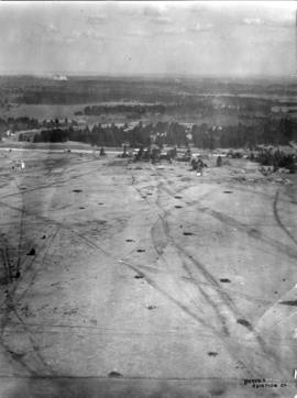
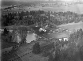
ca. 1920. Unidentified farm on unidentified lake probably in the Lakewood/Spanaway region of Pierce County. Aerial photograph was taken circa 1920 by the Barnes Aviation Co.