1976 Richards color stock footage. Overall aerial view of the bustling Port of Tacoma in October of 1976. Numerous ships are in port ready to load and unload cargo.
Aerial photographs; Aerial views; Cargo ships--Tacoma--1970-1980; Shipping--Tacoma--1970-1980; Port of Tacoma (Tacoma);
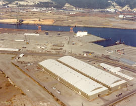
1976 Richards color stock footage. October, 1976, aerial view of Tacoma tideflats including various industrial facilities. This unidentified plant is believed to be along the Blair Waterway .
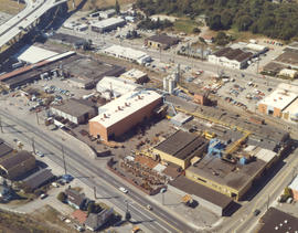
ca. 1976. Atlas Foundry by air in 1976. Established in 1899, Atlas's sprawling plant in the 3000 block of South Wilkeson was bordered by South Tacoma Way as well as Wilkeson (on right). Center St. is near the top. The Sprague Ave. overpass is in upper left corner along with offramp leading to Hwy 16. The plant's original buildings are near Wilkeson St. Atlas Foundry has been known as Atlas Castings & Technology since 2002. Photograph ordered by Atlas Foundry & Machine Co.
ca. 1976. Aerial view of longtime Tacoma foundry, Atlas Foundry & Machine Co., taken in the spring or summer of 1976. The company was founded in 1899 and began making iron castings for the Northwest logging industry. After the foundry was purchased by the Long family 30 years later, it began making steel as well as iron. By the 1930's, half of the firm's production was steel castings. Atlas is still in business in the 21st century; it is now known as Atlas Castings & Technology. This aerial photograph of the foundry in 1976 shows the city and roadways have grown in the 77 years since Atlas was founded. Atlas is bordered by Wilkeson (the long street extending vertically on the right) and South Tacoma Way (bottom) with Center St. on top. Stanley Elementary School is at the end of Wilkeson (top of photograph). I-5 freeway is on the bottom of photograph with the exits to So. 38th St. and Hwy 16 above. At the left corner of picture is the 25th St. bridge and Sprague Ave. (www.atlascastings.com)
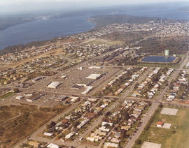
Series of aerials around the vicinity of South 19th & Pearl Sts. taken on behalf of Mueller Investment Co. on October 3, 1977. This view is believed to be a bit further north, near the Westgate Shopping Center and the North End water tower and reservoir.
Aerial photographs; Aerial views; Water towers--Tacoma; Reservoirs--Tacoma;
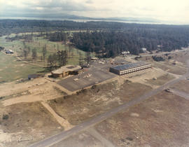
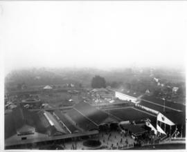
Aerial view of unidentified buildings. Construction may not yet be completed at this unidentified site near a heavily wooded area. There is a large section of cleared land near the two-lane roadways which may later be used for either homes or businesses. Color photograph ordered by Pacific Lanes.
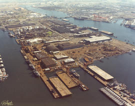
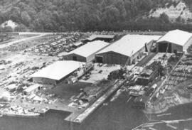
Copy of customer print. Aerial view of Tacoma Boatbuilding's plant alongside the Hylebos Waterway taken post-1969. The company's former location on the Sitcum Waterway had been destroyed by fire in 1968. They chose to build a new plant on Marine View Dr. on the Hylebos on 20 acres of land. Photograph ordered by Tacoma Boatbuilding.
Aerial views; Boat & ship industry--Tacoma--1970-1980; Tacoma Boat Building Co., Inc. (Tacoma); Hylebos Waterway (Tacoma); Logs;
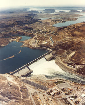
Undated color copy of photograph from the 1973 Richards stock footage. Aerial view of the Grand Coulee Dam and surrounding area. The dam is in the center with Lake Roosevelt behind. The Grand Coulee is a large hydroelectric dam located on the Columbia River.
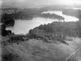
Lake Steilacoom - from the north end looking south. This undated aerial view of Lake Steilacoom was taken by the Barnes Aviation Co. A bridge is visible on the upper right connecting Interlaaken Dr. S.W. to Bridge Road on the west side of the lake. The road on the lower right corner is probably Lake Steilacoom Dr.
Aerial views; Aerial photographs; Lake Steilacoom (Wash.);