Showing 824 results

Collections
Aerial Photography Image With digital objects
Print preview View:

D160622-5

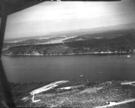
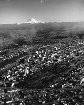
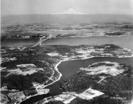
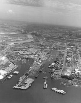
Snow capped Mount Rainier glows dimly in the background on this somewhat cloudy and/or foggy day in June of 1971. In the foreground are a portion of the Puyallup Waterway, St. Paul Waterway and Middle Waterway. On the left edge is St. Regis Paper Co. Barges floating near the mouth of the Middle Waterway are laden with chips and other materials. There are several log dumps visible. Photograph ordered by Foss Tug & Barge.


Aerial views; Rainier, Mount (Wash.); Puyallup Waterway (Tacoma); St. Paul Waterway (Tacoma); Middle Waterway (Tacoma); St. Regis Paper Co. (Tacoma)--1970-1980; Barges--Tacoma;

D7232-3

ca. 1938. Aerial view of North End Tacoma showing Annie Wright Seminary, surrounding neighborhood and Commencement Bay. The Tudor Gothic building was built in 1924 on a design by Sutton, Whitney & Dugan.


Aerial photographs; Private schools--Tacoma; Annie Wright Seminary (Tacoma)--Buildings;

D7232-5

Aerial view of North End Tacoma showing Annie Wright Seminary, surrounding neighborhood and Commencement Bay.


Aerial photographs; Private schools--Tacoma; Annie Wright Seminary (Tacoma)--Buildings;

D9334-6

Aerial view of Port Piers on January 13, 1940, showing transport ships. Log booms in background. The three larger vessels are the military transport ships, the Hunter Liggett, Leonard Wood and St. Mihiel. They will be boarding 7500 soldiers from Fort Lewis and taking them to join the 3rd Division Black Army at sea. During the upcoming war games, the Black Army will invade the coast of California from the sea. The games are the largest in US history and involve both the Army and Navy. In 1940, the military was looking ahead to possible involvement in the European conflict which would become World War II. (T. Times 1/11/1940, pg. 1)


Aerial photographs; Bays--Washington (State); Commencement Bay (Wash.); Port of Tacoma (Tacoma)--1940-1950; Logs; Ships;

D8245-3

Associated Oil Company aerial view of Northeast Tacoma, Vashon Island, and Commencement Bay. Ordered by George Martinac, North Pacific Bank Note Company.


Aerial photographs;

D8245-4

Associated Oil Company aerial view looking south toward Lakewood. Cemetery and highway in foreground. Ordered by George Martinac, North Pacific Bank Note Company.


Aerial photographs;

BOLAND-B22651

View by air of the 161st Infantry tents at Camp Dent on the grounds of Camp Murray. Camp Dent was the name of the 1930 encampment of the Washington National Guard. Thick stands of trees block the view of American Lake. G69.1-138 TPL-10319


Aerial views; Aerial photographs; Washington National Guard, 161st Infantry (Wash.); American Lake (Wash.);

BOLAND-B14964

Aerial view of Tacoma's east side and Cushman Hospital. The hospital for veterans is the cluster of buildings in the center of this June, 1926, photograph. Surrounding homes are nestled in wooded lots.


Aerial views; Aerial photographs; Cushman Hospital (Tacoma); Hospitals--Tacoma--1920-1930; Neighborhoods--Tacoma--1920-1930;

G8.1-009

ca. 1894. Business district of Tacoma (copy of original), circa 1894. Many of the streets surrounding Pacific Avenue in the 1890s, even then the heart of the city's financial district, were filled with a hodgepodge of wood framed buildings and more substantial brick structures. At the foreground are the Pioneer Paint Store, sellers of wallpaper, mouldings, paints, and glass and W.H. Robison's, where new and second hand goods could be purchased. The Freeman & Boggs livery stable, near left center, stood near the corner of 13th & Pacific. George A. Boggs, who was City Treasurer before going into private business, had been sent away to the state pen in Walla Walla after auditors found a $109,000 shortage in the city books. Also in the far right background is the steeple of the original St. Leo's Church near So. 11th & "D" St. S7.2, TPL-378 (Researched by Murray Morgan)


Commercial streets--Tacoma--1890-1900; Business districts--Tacoma--1890-1900; Freeman & Boggs Livery (Tacoma); Pioneer Paint Store (Tacoma); W.H. Robison (Tacoma);

G8.1-070

ca. 1960. Aerial view of Tideflats and downtown Tacoma area, including Wright Park and slices of Division Avenue, ca. 1960. Mount Rainier looms in the background, overlooking the industrial area of Tacoma, City (now Thea Foss) Waterway with its boats and log dumps, and the 11th St. Bridge. Familiar buildings such as the Puget Sound National Bank, Rust, and Washington buildings can be spotted on Pacific Avenue. The County-City Building with its two wings and the State Armory are in mid-photo. The wooded area is Wright Park with its meandering paths clearly marked. Adjoining the park at 9th & Division is the Greek Ionic styled First Church of Christ, Scientist. TPL-9664


Aerial photographs; Neighborhoods--Tacoma; Wright Park (Tacoma); Rainier, Mount (Wash.);

TPL-010

ca. 1939. Artistically modified aerial view of West Tacoma and the Tacoma Narrows. The bridge and the ship under it in the photo were painted in. The bridge was not yet complete in 1939. It would open for traffic on July 1, 1940 and go down in dramatic fashion on November 7, 1940.


Aerial views; Aerial photographs; Neighborhoods--Tacoma--1930-1940; Tacoma Narrows Bridge (Tacoma);

Results 811 to 824 of 824