Aerial view of Northern Pacific property at Lakeview. Closer view of land seen in D11794, image 1. This time buildings can faintly be seen in this photograph taken on August 22, 1941. Part of series ordered by Raleigh-Hayward Company.
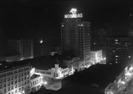
ca. 1941. Circa 1941 aerial view of the business district of Tacoma at night clearly showing the buildings on Pacific Ave. between 9th and 11th on the east side of the street. Buildings shown include: the Anderson building (1001-05 Pacific), the Bank of California (1011-1013 Pacific), and the Washington Building (1019 Pacific). There is a large neon sign for Mobil Gas on top of the Washington Building.
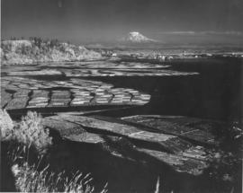
ca. 1943. Mount Rainier rises ghostlike above the Hylebos Waterway in this test photograph with the new infrared film. Log booms make designs in the water leading up to the Tideflats. Foliage has an eerie white glow. The photograph is believed to have been taken from the vicinity of the Cliff House.
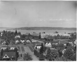
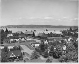
Annie Wright Seminary was a college preparatory school for girls. Miss Ruth Jenkins was the headmistress of the school. Aerial view of Annie Wright Seminary, Commencement Bay in background.
Annie Wright Seminary was a college preparatory school for girls. Miss Ruth Jenkins was the headmistress of the school. Aerial view of Annie Wright Seminary, Commencement Bay in background.
Ponder Sales & Service Inc. sold diesel stove and heavy fuel oils. They were located at 764 Commerce Street. Aerial view ordered by Ponder Sales and Service Co.
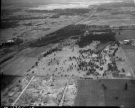
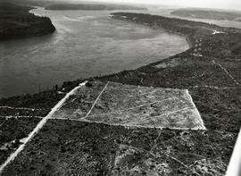
This aerial photograph from May of 1946 shows The Narrows and the northwest side of Tacoma north of Sixth Avenue and the entrance to the Narrows Bridge. The wide road at the left is Jackson Avenue, and the large, cleared area of land in the center is "Edward P. Miller's 40 Million Dollar Country Club Estates, Tacoma's Exclusive Residential Development." The roads that cut diagonally across the development (right, bottom to left, top)are now James Street, Narrows Drive, and Fremont. TPL-3810
Aerial photographs; Aerial views; Housing developments--Tacoma--1940-1950; Land subdivision--Tacoma; Clearing of land--Tacoma;
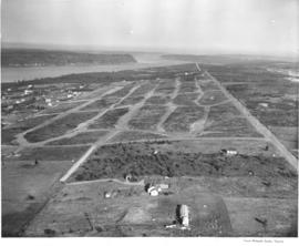
This aerial view of the west side of Tacoma, taken in February, 1947, shows the area north of South 19th and west of Jackson Avenue just north of University Place. Streets have been graded for the future development of Narrowmoor, a residential community of custom built, single-family homes. In 1960, a report by the City of Tacoma stated that Narrowmoor covers an area of 11 blocks by 6 blocks and ranked as "the largest subdivision of quality housing in the city"; all building sites have an excellent view of the Narrows; lots are selling for $5,000 to $8,000; and, homes range in value from $25,000 to $100,000. In 1947 there was no bridge across the narrows. (Report by the City of Tacoma to the Japan Housing and Community Development Team, Tacoma, Washington, August, 1960). TPL-919
Aerial views; Aerial photographs; Land use--Tacoma;
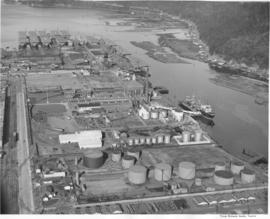
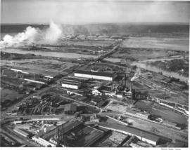
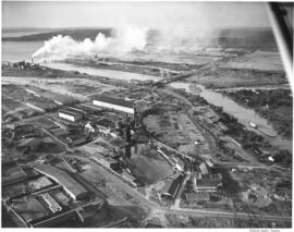
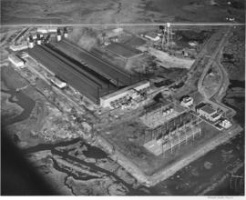
Aerial view of Hooker Chemicals Plant on the tideflats. A recent merger brought Hooker Electrochemical Company of Tacoma and Niagara Falls, New York and the Detrex Corporation of Detroit, Michigan together, bringing a new company in the chemical industry to Tacoma. The Hooker-Dextrex plant can be seen towards the the top of the image (north), just lower left of the ship yard's water tower. Hooker companies were spread throughout 47 acres in Tacoma (T. Times, 2/26/1947 3B).
Studio aerial views for Tacoma Times 18 page Business and Industrial Review. Tacoma industries were growing and expanding, gaining national and international recognition. Tacoma was a leader in many industries including: boat and ship building, machinery development, lumber and plywood, chemical plants, grocery wholesalers and flour mills (T. Times, 2/26/1947, Sec. B).
Aerial views; Aerial photographs; Waterfronts--Tacoma; Land use--Tacoma; Industrialization--Tacoma;
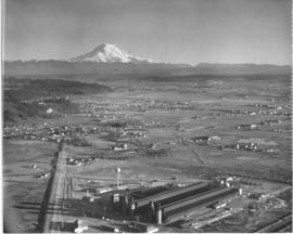
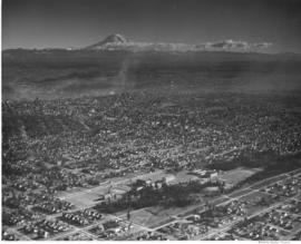
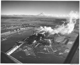
Aerial photos were taken for the Tacoma Times Business and Industry Review, an eighteen page supplement in the February 26, 1947 edition, highlighting many of Tacoma's industries and businesses. Housing, boat building, machinery manufacturing, chemicals, lumber, paper and pulp, grocery wholesale and fuel were some of the industries featured in the layout. Aerial view of industrial facility with majestic Mount Rainier in background. TPL-10569
Aerial views; Aerial photographs; Industrial facilities--Tacoma; Rainier, Mount (Wash.);
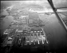
Aerial view of West Coast Grocery, St. Paul and Tacoma lumber and Tacoma Iron and Steel. A view of the Tacoma tideflats and some of the industry built on it looking north.
Aerial view of West Coast Grocery, St. Paul and Tacoma Lumber Company and Tacoma Iron and Steel. A view of the Tacoma tideflats and some of the industry built on it looking northwest. Log booms are seen in the waterways. One of the bridges on the Puyallup River is open. TPL-5892
Tacoma Tideflats (Tacoma); Aerial photographs; Puyallup River (Wash.); Industry--Tacoma--1940-1950;
Aerial view of West Coast Grogery, St. Paul and Tacoma Lumber Company and Tacoma Iron and Steel. A view of the Tacoma tideflats and some of the industry built on it looking east. Log booms are seen in two of the waterways. TPL-3215 and TPL-3659
Tacoma Tideflats (Tacoma); Aerial photographs; Puyallup River (Wash.); Industry--Tacoma--1940-1950;
Aerial view on July 13, 1947 of West Coast Grocery, St. Paul and Tacoma Lumber Company and Tacoma Iron and Steel. A view of the Tacoma tideflats and some of the industry built on it looking northeast.
Permanente Metals, producers of Kaiser Aluminum, bought the Olin plant and after rehabilitating and improving the facilities, they have started production. They began operating one pot line, but within a month they should be producing aluminum at full capacity. The Tacoma plant is one of the most modern aluminum producing facilities in the country. Aerial view of Permanente, which is located on the Tacoma Tideflats, covering more than 129 acres of land (PMC Annual Report, 1947-48).
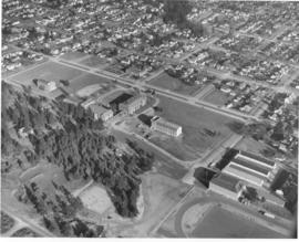
ca. 1947. An aerial photograph shows the College of Puget Sound campus lying between Union Avenue and Alder Street. Jones Hall is prominent in the center of the complex. TPL-6703
Aerial photographs; Universities & colleges--Tacoma; College of Puget Sound (Tacoma)--Buildings;
Aerial view of Tacoma, tide flats, CPS, City downtown area. This elevated view shows the Tacoma tideflats and the waterways that run and were cut through it, the Puyallup Valley and Mount Rainier in the background. Log booms are strung together in the forefront, near St. Regis paper mill. The Port of Tacoma had been working with reclaimation of the tidelands, construction of deep waterways and lease or sale of suitable sites for new factories for nearly 30 years since Tacoma voters approved a plan of development under an elective commission. During the decade of the 1940's an extended program had been developed which was to ensure hundreds of acres of new sites and provision for more deep water frontage for those to whom ocean commerce was vital. Mount Rainier is seen in the background. (T.Times, 1/12/1948, p.5)
Aerial photographs; Harbors--Tacoma--1940-1950; Waterfronts--Tacoma; Logs; Land use--Tacoma--1940-1950; City planning--Tacoma--1940-1950; St. Regis Paper Co. (Tacoma)--1940-1950; Paper industry--Tacoma--1940-1950; Rainier, Mount (Wash.);
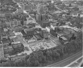
This aerial view of downtown Tacoma, taken in May of 1948, shows the city looking up 9th Street from the railroad tracks that line the waterfront to Tacoma Avenue. Prominent in the foreground is the parking lot located at the former location of the Tacoma Hotel, 913 A Street. The hotel occupied the site from 1884 until it was destroyed by fire in 1935. In 1988, the Frank Russell Co. built their offices at this location. Left of the parking lot on A St. were (l to r): the Tacoma Building (1017-21 A St.), the Lawrence Block (1009-15 A St.- demolished) and the Mason Block (1001-07 A St.- demolished.) The Weyerhaeuser Building (1015 A St.) now occupies the site of the demolished buildings. Also shown is the Hotel Winthrop (773 Broadway) across 9th St. from the Pantages Theater (902 Broadway). The Tacoma Theater (902-14 Broadway) can be seen behind the Pantages and the Medical Arts building (747 Market- now the Tacoma Municipal Building) can be seen beyond the Winthrop. Photograph ordered by Miss Helen Whitney. TPL-1440
Aerial photographs; Hotel Winthrop (Tacoma); Cityscapes; Railroad tracks--Tacoma; Business districts--Tacoma; Commercial streets--Tacoma--1940-1950;
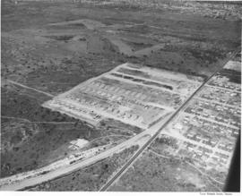
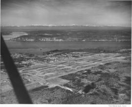
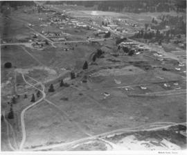
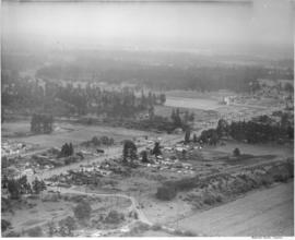
South Tacoma was featured in the Tacoma Times Labor Day Industrial pages, the area was rapidly expanding and contributing many new jobs and homes to Tacoma community members. Aerial view of available area, neighborhoods and the Star-Lite Park In Theatre (background), all located along South Tacoma Way (T. Times, 8/31/48, p. 21).
Cities & towns--Tacoma; City & town life--Tacoma; Aerial views; Aerial photographs; Neighborhoods--Tacoma; Drive-in theaters--Tacoma; Star-Lite Park In Theatre (Tacoma); South Tacoma Way (Tacoma);
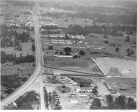
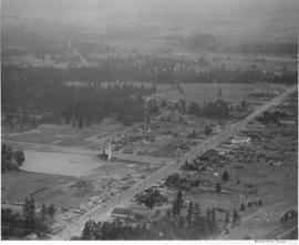
The Auto-View Theater was located on South Tacoma Way and South 99th Street. At 9915 South Tacoma Way was the Motel Fontaine, at the bottom center in this photograph. Aerial view of available area, neighborhoods and the Auto-View Theater (right side), all located along South Tacoma Way (T. Times, 8/31/48, p. 21).
Cities & towns--Tacoma; City & town life--Tacoma; Aerial views; Aerial photographs; Neighborhoods--Tacoma; Drive-in theaters--Tacoma; Auto-View Theater (Tacoma); South Tacoma Way (Tacoma);
Cooperation between South Tacoma employers and employees have played an important role in the steady growth of this south side community. South Tacoma businesses and industries have helped raise the overall payroll of the city. View of available area, neighborhoods and the Star-Lite Park In Theatre located along South Tacoma Way (T. Times, 8/31/48, p. 21).
Cities & towns--Tacoma; City & town life--Tacoma; Aerial views; Aerial photographs; Neighborhoods--Tacoma; Drive-in theaters--Tacoma; Star-Lite Park In Theatre (Tacoma); South Tacoma Way (Tacoma);
Aerial view of South Tacoma Way and the surrounding community. South Tacoma has been expanding rapidly since the end of World War II with growth in the industrial, business and residential areas. View of neighborhoods and the Star-Lite Park In Theatre located along South Tacoma Way as taken in August of 1948. (T. Times, 8/31/48, p. 21) TPL-9090
Cities & towns--Tacoma; City & town life--Tacoma; Aerial views; Aerial photographs; Neighborhoods--Tacoma; Drive-in theaters--Tacoma; Star-Lite Park In Theatre (Tacoma); South Tacoma Way (Tacoma); Streets--Tacoma--1940-1950;
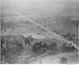
Aerial view of the Star-Lite Park In Theatre, which opened in May 1948. Tacoma's Star-Lite Theatre was one of the largest outdoor theaters in the world. South Tacoma Way runs through the center of the photo, an athletic field is located on south side of theater (T. Times, 8/31/48, p. 21).
Cities & towns--Tacoma; City & town life--Tacoma; Aerial views; Aerial photographs; Athletic fields--Tacoma; Drive-in theaters--Tacoma; Star-Lite Park In Theatre (Tacoma); South Tacoma Way (Tacoma);
South Tacoma has many new developments, industrial facilities, businesses and new residential neighborhoods. The residential areas are said to be ideally situated between the industries and businesses. Aerial view of available area, neighborhoods and the Star-Lite Park In Theatre (left side), all located along South Tacoma Way (T. Times, 8/31/48, p. 21).
Cities & towns--Tacoma; City & town life--Tacoma; Aerial views; Aerial photographs; Neighborhoods--Tacoma; Drive-in theaters--Tacoma; Star-Lite Park In Theatre (Tacoma); South Tacoma Way (Tacoma);
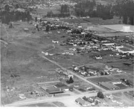
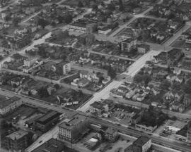
On August 18, 1948, the Richards Studio photographer flew around the city of Tacoma taking shots of various neighborhoods and individual streets. This aerial view is of S. 15th & Market Sts. near downtown Tacoma. The street running left to right at the bottom is 15th St. The light colored street at center is Market St. The Labor Temple, built circa 1941, is at the corner of 15th & Market (actual address of 1355 Market St.)
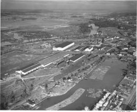
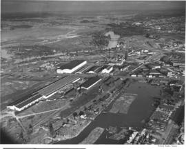
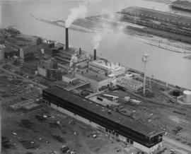
Aerial view, taken in August of 1948, of the large St. Regis Paper Co. plant located in Tacoma's industrial Tideflats. Waterway in center is the Puyallup Waterway. St. Regis was undergoing expansion as depicted by the unfinished building in the foreground. Three years later a big new bag plant would be built, adding to Tacoma's payroll.
Aerial photographs; Aerial views; St. Regis Paper Co. (Tacoma)--1940-1950; Paper industry--Tacoma--1940-1950; Industrial facilities--Tacoma--1940-1950; Building construction--Tacoma--1940-1950; Puyallup Waterway (Tacoma);