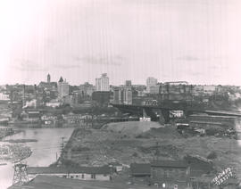
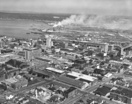
Showing 824 results

Collections
Aerial Photography Image With digital objects
Print preview View:

D129800-186

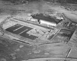
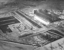
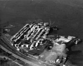
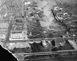
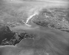
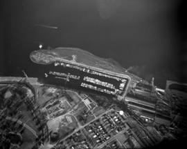
ca. 1961. Circa 1961 aerial view of Tacoma Yacht Club, ASARCO smelter, Point Defiance Park and Ruston. The large, long buildings to center left belong to the copper smelter ASARCO. To the right of ASARCO is the Tacoma Yacht Club and its mooring. Above the Yacht Club is the outline of Pt. Defiance's amusement park Funland. To the upper right hand of the photograph is the pond garden in the Bowl area entrance to Point Defiance. To the upper center is the city of Ruston.


Aerial photographs; Boathouses; Boats; Tacoma Yacht Club (Tacoma); Mooring; American Smelting & Refining Co. (Tacoma); Smelters--Tacoma--1950-1960; Funland (Tacoma); Point Defiance Park (Tacoma); Amusement parks--Tacoma--1930-1940;

A129800-158

Traffic was flowing smoothly in this November 1961 aerial photograph of the Tacoma Narrows Bridge. The camera was looking east toward the rapidly developing west end of Tacoma. The graceful lines of the suspension bridge span nearly one-half mile, making it the 5th longest suspension bridge in the US. This was the second Narrows Bridge, dedicated in 1950; the first collapsed in high winds on November 7, 1940, only four months after its dedication. The 1950 bridge was designed to carry 60,000 cars a day. When area population growth increased that number by half, a third bridge was added; parallel to and south of the 1950 bridge. The third Narrows bridge was dedicated in July of 2007 and carries east bound traffic, leaving all lanes of the 1950 bridge open for west bound traffic. (www.wsdot.wa.gov)


Aerial photographs; Tacoma Narrows Bridge (Tacoma); Suspension bridges--Tacoma; Bridges--Tacoma--1960-1970; Neighborhoods--Tacoma--1960-1970;

D150900-357

1967 Richards stock file. Aerial view of the So. 19th & Union Ave. neighborhood taken on October 28, 1967. This view looks toward So. Union. The massive Elks Temple is in the foreground with Allenmore Medical Center in center. The Elks membership had moved from its Broadway location, built in 1916, to this north end neighborhood near Allenmore Golf Course in 1965. The Allenmore Medical Center, also opened in 1965, was a medical-dental building with a 50-bed hospital. It was built on a 22-acre tract on what had been part of the old Allenmore golf course. The $2,000,000 center was designed by E.L. Mills & Associates and built by Norman Strom Construction. Wooded area across So. 19th from Allenmore would eventually become a Puget Sound National Bank branch (now Key Bank). TPL-9324


Aerial photographs; Elks Temple (Tacoma); Benevolent and Protective Order of Elks, Tacoma Lodge No. 174 (Tacoma); Allenmore Medical Center (Tacoma);

D150900-369R

1967 Richards stock footage. October, 1967, aerial of Tacoma Tideflats. Smoke drifts through the air from several chimneys. Large plant is believed to be the Kaiser Aluminum facility.


Aerial photographs; Industrial facilities--Tacoma--1960-1970;

D150900-370R

1967 Richards stock footage. Another view of Kaiser Aluminum plant in Tacoma Tideflats, taken in the fall of 1967. Kaiser had reopened its Tacoma plant in 1964 after being closed for six years. It planned an expansion of the plant facilities and in 1968, a new aluminum rod mill was ready for operation. A second alumina dome with a 100,000 ton capacity, would be completed on Pier 7 in 1969.


Aerial photographs; Kaiser Aluminum & Chemical Corp. (Tacoma); Aluminum industry--Tacoma--1960-1970; Industrial facilities--Tacoma--1960-1970;

D150900-362

1967 Richards stock footage. Aerial view of Kaiser Aluminum plant featuring Kaiser Dome. Tankers brought alumina from Australia to be manufactured into aluminum. The finished product was then shipped out of Tacoma by water, highway, or rail. Thousands of tons of aluminum were processed each year at Kaiser Aluminum's Tideflats plant, about five miles north of downtown Tacoma. The dome in the center of this October 28, 1967, photograph was used to store ore. It, along with a later dome, was dismantled in March, 2005. Kaiser Aluminum, after reopening the Tacoma plant in 1964, finally closed its doors permanently in 2002. (Olsen: First 100 Years: Tacoma Beginnings, p. 115)


Aerial photographs; Kaiser Aluminum & Chemical Corp. (Tacoma); Aluminum industry--Tacoma--1960-1970; Storage tanks--Tacoma;

D151503-3

Additional view by air of the E. 83rd and 84th St and Portland Avenue neighborhoods on April 11, 1967. Landscape shows room for expansion with large lots still unfilled. Water tower at top central portion of photograph. Photograph ordered by Puget Sound National Bank.


Aerial photographs; Neighborhoods--Tacoma--1960-1970;

D152004-11C

Aerial view of Tacoma Tideflats taken in the summer of 1967. This may be the Blair Waterway near the top of the color photograph. Automobiles and trains appear to be toy-like when viewed from above. The large whitish-gray mound in the murky brown depression may be sand or gravel; a curving roadway of the same hue leads to the Graymont Western lime plant near the waterway. The building to the south is the G-P Gypsum plant, 1240 Alexander Ave. (Additional information provided by a reader)


Aerial photographs; Industrial facilities--Tacoma--1960-1970; Graymont Western (Tacoma);

D152788-13C

Mount Rainier looms faintly in the distance, providing a majestic sight for the residents of the large Lively Oaks Apartments in Lakewood. An aerial view in December, 1967, shows the sprawling complex which was located at the entrance to the Oakbrook subdivision. Lively Oaks would grow even larger in 1969 as the H.A. Briggs Co. would build Lively Oaks South, possibly in the vacant land adjacent to the original complex. Color photograph ordered by Fairway Investments, Inc.


Aerial photographs; Lively Oaks Apartments (Lakewood); Housing developments--Lakewood--1960-1970; Rainier, Mount (Wash.);

D153511-2

Downtown and freeway aerial view of February 13, 1968, on behalf of Puget Sound National Bank. I-5 is lower center, running horizontally. Six more ramps at the Pacific Ave. interchange and part of the 38th St. interchange (not shown) would be opened on 2-14-68. Wavy line in center is Hwy. 7. Pacific Ave. is long vertical road near right side; Puget Sound Hospital is next to Pacific Ave. on its right. Tacoma Dome will be constructed in the future in the neighborhood at the lower left corner. (TNT 2-11-68, C-19)


Aerial photographs; Cityscapes; Express highways--Tacoma--1960-1970; Puget Sound Hospital (Tacoma);

D153511-17

February 13, 1968, aerial view of 112th St. in Puyallup taken on behalf of Puget Sound National Bank. 112th St. had a mixture of homes with large lots and business development. New construction is occurring in lower center of photograph with large building's walls partially in place.


Aerial photographs; Neighborhoods--Puyallup;

C153566-1

Copy of customer copy. Aerial view of SR410, Puyallup to Sumner, with major state routes and roads clearly marked, ca. January, 1968. Visible are SR 161, 512, 167 and 410. Photograph ordered by Ward Smith, Inc., on February 20, 1968.


Aerial photographs; Express highways--Wash.;

C153566-3

Copy of customer's print. Photograph by air of SR 512 in Puyallup dated December, 1967. Major streets in Puyallup including 10th St. SE, Main Ave., Pioneer and Milwaukee, are clearly labeled as well as SR410 and directions to neighboring cities of Tacoma, Sumner and Parkland. The proposed Puyallup Valley freeway's effect on Puyallup is shown in the above mockup by the State Department of Highways. The system should be operable by late 1970. It was expected to cost $16 million dollars. Photograph ordered by Ward Smith, Inc., on February 20, 1968. (TNT 3-26-68, p. 8)


Aerial photographs; Express highways--Wash.;

D154000-28C

1968 Richards stock footage. Colorful aerial view of downtown Tacoma business district and 11th St. Bridge crossing the City (now Thea Foss) Waterway, taken on February 13, 1968. Stradling 11th St. near the bridge are the Tacoma Bldg. and Perkins Bldg. To the right is the Art-Deco styled Medical Arts Bldg., 747 Market St. County-City Building, near 11th & Tacoma Ave. So., is center-left. Woods are part of Wright Park.


Aerial views; 11th Street Bridge (Tacoma); Tacoma Building (Tacoma); Perkins Building (Tacoma); Medical Arts Building (Tacoma); County-City Building (Tacoma); Commercial streets--Tacoma--1960-1970; Wright Park (Tacoma);

D154000-268

Closer view of the downtown business district as seen by air on September 4, 1968. Facing Pacific Ave. is the Puget Sound National Bank Bldg. with its familiar spire. The empty lot across it would soon be home to a 300+-spot parking lot. Behind the bank is the Federal Building (1102 A Street) where the federal courts were located (until 1992) and the Main branch of the U.S. Postal Service. The Rust Building (950 Pacific) and the 17-story Washington Building (1019 Pacific) are less than a block away. In the far background, near top of the photograph, are the County-City Building (930 Tacoma Ave. So.) and Central School (601 So. 8th St.)


Aerial views; Aerial photographs; Business districts--Tacoma--1960-1970; Puget Sound National Bank (Tacoma); Washington Building (Tacoma); Federal Building (Tacoma); County-City Building (Tacoma); Central School (Tacoma);

D154000-274

1968 Richards stock aerial footage. The downtown area was still considered the city's center of commercial business. Major banks and stores were in close proximity to the industrial Tideflats with easy access via the 11th Street Bridge. This September, 1968, view shows several easily identifiable landmarks: the U-shaped with tower Central School, the winged-shaped County-City Building, and Tacoma Public Library all on Tacoma Ave. approximately in the center of the photograph. The Art-Deco Medical Arts Building on 7th & Market is on left center. Puget Sound National Bank's unique spire is at 11th & Pacific, relatively close to the City (now Thea Foss) Waterway.


Aerial views; Commercial streets--Tacoma--1960-1970; Central School (Tacoma); County-City Building (Tacoma); Tacoma Public Library (Tacoma); Medical Arts Building (Tacoma); Puget Sound National Bank (Tacoma); 11th Street Bridge (Tacoma);

D154000-86

1968 Richards aerial stock footage. Stadium High School, portion of Stadium Bowl. Stadium High School, which is currently undergoing extensive remodeling in 2005, resembles a French chateau. It has a magnificent view of Commencement Bay. Built but never completed as a hotel, it converted to a high school in 1905. A small portion of Stadium Bowl, including rows of bleachers, is visible lower left corner. Originally the bowl had a seating capacity of nearly 24,000; however, after numerous mudslides, it has a reduced modern capacity of 15,000. TPL-10144


Aerial views; Stadium High School (Tacoma); Public schools--Tacoma--1960-1970; Stadium Bowl (Tacoma);

BOLAND-B23717

Aerial view looking toward Tacoma's City Center. This May, 1931, view shows many prominent Tacoma landmarks including the Tacoma Building and Perkins Building flanking the 11th Street Bridge (now Murray Morgan Bridge); the newly completed 17-story Medical Arts Building (at center-right); the towering Washington Building at center; Puget Sound National Bank with spire (center-left) and the Pierce County Courthouse with tower in the far left background. TPL-1347; G8.1-021


Cityscapes; Aerial photographs; Aerial views; 11th Street Bridge (Tacoma); Tacoma Building (Tacoma); Medical Arts Building (Tacoma); Washington Building (Tacoma); Puget Sound National Bank (Tacoma); Pierce County Courthouse (Tacoma);

TPL-835

ca. 1938. Dickman Lumber, 2423 Ruston Way. This aerial view, taken circa 1938, shows vast stacks of lumber ready to be loaded onto ships. Dickman Lumber was located just south of the present Old Town dock. It was purchased in 1922 by Leonard Howarth and Ralph L. Dickman, Sr. Dickman Lumber was closed in September of 1977 and its mill destroyed by fire in January of 1979.


Aerial photographs; Dickman Lumber Co. (Tacoma); Lumber industry--Tacoma--1930-1940; Shipping--Tacoma--1930-1940;

G9.1-085

ca. 1958. Aerial view of No. 30th Street and Ruston Way. The largest street running vertically in the photograph is No. 30th Street. The street running along side of the water is Ruston Way. Just below the bottom of the picture is the intersection with Starr Street. The next street (that crosses the railroad tracks) is McCarver. The businesses running along Ruston Way (from the bottom up) are the Ocean Fish Mart, the Top of the Ocean nightclub, a small office building, Tacoma Boat Mart and the Dickman Lumber Mill (the largest group of buildings.) TPL-8657


Aerial photographs--Tacoma--1950-1960; Ocean Fish Mart (Tacoma); Top of the Ocean (Tacoma); Dickman Lumber Mill (Tacoma);

G9.1-112

ca. 1961. Aerial looking south by Oswald Flying Service of the neighborhoods including the Lincoln district circa 1961. Lincoln High School (701 So. 37th) and Lincoln Bowl are near the top right adjacent to So. "G" St. Cartozian & Sons Rug Co., in the large old Bye Thompson Motors building at 3320 So. "G," is further north. The massive stand of trees is part of Lincoln Park. The street to the left of "G" is Tacoma Avenue. The big building in the upper center on Tacoma Avenue is the St. Joseph Catholic Church, at the corner of So. 34th & Tacoma Ave. Holy Rosary Catholic Church, school and rectory (in the 500 block of So. 30th) are near the bottom center of the photograph. Delin St. is at the very bottom of the picture. At the upper left corner of the photograph is Pacific Avenue. Mountain View General Hospital (later renamed Puget Sound General Hospital in 1969) is at 3572 Pacific Ave., the large set of buildings near the upper left corner. G9.1-112


Aerial photographs; Neighborhoods--Tacoma--1960-1970; Streets--Tacoma--1960-1970; Holy Rosary Church (Tacoma); Lincoln High School (Tacoma); Lincoln Bowl (Tacoma); Cartozian & Sons Rug Co. (Tacoma); St. Joseph's Catholic Church (Tacoma);

BOWEN TPL-672

ca. 1929. Head of Commencement Bay while Sullivan Service at 101 Puyallup Ave. (lower left) was under construction. This aerial view was taken circa 1929. Visible landmarks and streets included: the Union Station at upper left corner; Albers Bros. Milling Co. at upper center (large darker building) ; Northwest Woodenware Co. at center along waterway; Wheeler-Osgood Co.'s saw mill at right center. The Sullivan Service was being built at this time facing Puyallup Ave. at left. Puyallup Ave., which runs horizontally left to right, also had the Independent Paper Stock Co. kitty-corner from Sullivan's at 132 Puyallup Ave. The Washington Gas & Electric Co. was also on the same side of Puyallup Ave. as the Independent Paper Stock Co., at 212-216, and was the large building near right. The street at lower bottom running left to right is South 25th St. E. (photograph torn at left corner)

BOWEN TPL-7624

ca. 1935. This is an aerial view of South 43rd and "L" Sts. circa 1935. South "L" runs horizontally in front of the Engine House No. 8 (4301 South "L"). The fire station was built in 1909, replacing the original which had moved to 4102 South "M." Neighboring lots appear small with many trees. BU-2125

BOLAND-B15239

View by air in July of 1926 of the 146th Field Artillery camp at Camp Lewis. G69.1-137


Aerial views; Aerial photographs; Camp Lewis (Wash.);

D142189-5

Photographs taken by air of the Port of Tacoma and industrial Tideflats area in July, 1964. Looking southwest, Dash Point is large area protruding on the left. Smoke is billowing from St. Regis Paper Co. facilities on the Puyallup Waterway which ran day and night. Photograph ordered by Puget Sound National Bank.


Aerial photographs; Dash Point (Wash.); St. Regis Paper Co. (Tacoma)--1960-1970; Smoke--Tacoma;

D141559-2

Closer aerial view of the Villa Plaza Shopping Center in Lakewood taken on April 26, 1964. A large area appears to be ready to be developed towards the upper center of photograph. Retailers were learning that customers would be attracted to one-stop shopping with plenty of free parking close to home. Supermarkets, department stores and banks were conveniently located very close by to one another. Photograph ordered by Puget Sound National Bank.


Aerial photographs; Villa Plaza Shopping Center (Lakewood); Shopping centers--Lakewood--1960-1970; Neighborhoods--Lakewood--1960-1970;

D142614-1

Aerial view of US Oil & Refining Co. plant and its many storage tanks, located in the Tideflats, and taken on August 8, 1964. By 1964, the plant, built at a cost of $10 million dollars, had been in operation for nearly eight years. It was located on a 120-acre site south of Lincoln Ave. Photograph ordered by US Oil & Refining Co.


Aerial photographs; US Oil & Refining Co. (Tacoma); Petroleum industry--Tacoma--1960-1970; Storage tanks--Tacoma;

D144001-296

Another in the series of Richards Stock File 1965 aerial photographs of the downtown Tacoma area looking toward the 11th St. Bridge and the Tideflats industrial area. The State Armory, Tacoma Vocational-Technical Institute and St. Leo's School are on one of the major thoroughfares, Yakima Ave. The next major street is below Yakima Ave.; Tacoma Ave. So. holds the County-City Building with its two wings, and Tacoma Public Library. Closer to the City (now Thea Foss) Waterway are major banks, Puget Sound National Bank and Bank of California, found on Pacific Ave. The Rust, Washington, Tacoma and Perkins Buildings are in close proximity. TPL-501


Aerial photographs; Commercial streets--Tacoma--1960-1970; State Armory (Tacoma); St. Leo's Parochial School (Tacoma); County-City Building (Tacoma); Tacoma Public Library (Tacoma); Puget Sound National Bank (Tacoma); Rust Building (Tacoma);

D144001-297

Stock Richards file. Aerial photograph of downtown Tacoma area, looking in northeasterly direction towards the Tideflats, taken on June 5, 1965. Smoke from St. Regis billows across the bustling industrial Tideflats on an otherwise clear summer day. Major landmarks on the city side near the City (now Thea Foss) Waterway are clearly discernable, including the Tacoma Building, Puget Sound National Bank and its distinct spire, and the 11th St. Bridge. Further west are the County-City Building with its two wings, Tacoma Public Library, State Armory, Tacoma Vocational-Technical Institute, and St. Leo's School.


Aerial photographs; Commercial streets--Tacoma--1960-1970; Tacoma Building (Tacoma); Puget Sound National Bank (Tacoma); City Waterway (Tacoma); 11th Street Bridge (Tacoma); County-City Building (Tacoma); Tacoma Public Library (Tacoma);

Results 151 to 180 of 824