Showing 824 results

Collections
Aerial Photography Image With digital objects
Advanced search options
Print preview View:

D165187-1

ca. 1974. This view of the Kaiser Aluminum plant is a cropped version of D165187, image A. It was taken circa 1974 with the focus on the 500-foot stack near right center. The stack was built in 1968, the same year Kaiser's new aluminum rod mill commenced operation.


Aerial views; Kaiser Aluminum & Chemical Corp. (Tacoma); Industrial facilities--Tacoma--1970-1980; Aluminum industry--Tacoma--1970-1980; Smokestacks--Tacoma;

D165044-2

Aerial view of Tacoma's west end neighborhoods on August 28, 1974. Main streets shown above are Pearl (running toward Point Defiance) and Sixth Avenue (more diagonally). Hunt Junior High School (now Middle) with its mushroom-shaped cafeteria/auditorium is at the bottom of the photograph. On the left side of Sixth Ave. is the Highland Hill(s) shopping center with Ernst Hardware (white building) nearby. On the left of Pearl is the Auto View Drive-In at the center of the photograph. ASARCO's smokestack is near the top of the picture. Photograph ordered by Puget Sound National Bank.


Aerial views; Neighborhoods--Tacoma--1970-1980; Auto View Drive-In (Tacoma); Henry F. Hunt Junior High School (Tacoma); Highland Hills Shopping Center (Tacoma); Smokestacks--Tacoma;

D165044-18

Aerial view of Sixth Avenue close to Orchard St. This August 28, 1974, view by helicopter shows the enormous Kmart parking lot with room for 1000 cars. Directly across the street is the new Goodyear Service, 5131 Sixth Avenue, managed by Chuck Ackley. The First Christian Church, at Sixth & Orchard, is separated from the Goodyear store by a thick strand of firs. Smaller strip malls have since been erected on the wooded sites to the left and rear of the Goodyear store. Photograph ordered by Puget Sound National Bank.


Aerial views; Neighborhoods--Tacoma--1970-1980; Parking lots--Tacoma--1970-1980; Kmart (Tacoma); Goodyear Service (Tacoma); First Christian Church (Tacoma);

D165802-38

I-5, SR18 and Weyerhaeuser headquarters. The Richards Studio photograph took a series of photographs of the area between 320th in Federal Way, North Puyallup, Pacific Highway South and Valley Ave. on March 27, 1975, for Puget Sound National Bank. The I-5 freeway runs at the bottom of the photograph. State Route 18 is toward the top. This is also a closer view of the Weyerhaeuser Corporation's headquarters which were built in 1971 in Federal Way. Previously the company had been based in Tacoma. Weyerhaeuser would celebrate its 100th annivesary in January of 2000.


Aerial views; Weyerhaeuser Timber Co. (Federal Way); Express highways--Wash.;

D166700-92C

1976 Richards color stock footage. This is believed to be the St. Regis Paper Co. facility as seen by air on October 4, 1976. Massive clouds of smoke and steam emerging from the plant will soon be dispersed by the wind. This view shows several of the city's waterways and a portion of downtown Tacoma. The placid waters of the Puyallup, St. Paul, Middle and City (now Thea Foss) Waterways and the 11th St. Bridge (now Murray Morgan Bridge) are on view.


Aerial views; Aerial photographs; St. Regis Paper Co. (Tacoma)--1970-1980; Industrial facilities--Tacoma--1970-1980; Smoke--Tacoma; Puyallup Waterway (Tacoma); St. Paul Waterway (Tacoma); Middle Waterway (Tacoma); City Waterway (Tacoma);

D166000-197C

ca. 1975. 1975 Richards color stock footage. Encroaching shadows seek to wrap themselves around the landmark Union Station located at 1717 Pacific Avenue. In 1975 the station still served as an Amtrak passenger terminal. Efforts were made to restore the station to its former glory with the proposed $14,000,000 "Depot Galleria" shopping/transportation complex; however, these plans were stalled. Also visible in this aerial view is the multi-storied Albers Mill, located to the rear of the station at 1821 Dock St. TPL-7982


Aerial views; Aerial photographs; Union Station (Tacoma); Railroad stations--Tacoma--1970-1980; Albers Bros. Milling Co. (Tacoma);

D166000-195C

ca. 1975. 1975 Richards color stock footage. Aerial view of rear of Union Station, 1717 Pacific Ave. as seen in 1975. Fast-forward 30+ years later and the landscape has changed drastically. SR-705 is now where the railroad tracks once ran. The parking lot to the left of the station is now the location of the Washington State History Museum; the Federal Courts are located to the north in a new wing. The five-story building on Pacific Ave. on the extreme left of the photograph is now the University of Washington Bookstore. TPL-2402


Aerial views; Aerial photographs; Union Station (Tacoma); Railroad stations--Tacoma--1970-1980; Railroad tracks--Tacoma--1970-1980;

D159700-246C

1971 color Richards stock footage. Aerial view of ASARCO (American Smelting & Refining Co.) in May of 1971. Two ships are docked to be loaded with metals for shipment outside Washington state. The famous ASARCO smokestack is near the right corner edge; the 571-foot giant chimney was imploded in 1993, nine years after the plant had closed. The dark gray color of the plant grounds is in stark contrast to the deep blue waters of Puget Sound; the color is due to slag.


Aerial views; American Smelting & Refining Co. (Tacoma); Smelters--Tacoma--1970-1980; Smokestacks--Tacoma;

D159700-184C

ca. 1971. 1971 color Richards stock footage. Aerial view of downtown commercial district with glimpse of industrial Tideflats. This is a look at the area around So. 12th and Pacific Avenue with the towering Bank of Washington Plaza attracting the viewer's eye. The giant circle surrounded by a spaced planting of trees is the plaza's fountain. A circular staircase leads down to the fountain and courtyard, with a restaurant and specialty shops included. Directly across the street from the fountain is the Park Plaza South parking garage. The Pacific National Bank of Washington's closest banking neighbors are Puget Sound National Bank (with spire) and Seattle-First, in left corner. The City Waterway (now Thea Foss Waterway) is in the background with the railroad bridge and the 15th St. Bridge connecting the city with the industrial Tideflats area.


Aerial views; Pacific National Bank of Washington (Tacoma); Puget Sound National Bank (Tacoma); Seattle-First National Bank (Tacoma); Banks--Tacoma; Parking garages--Tacoma--1970-1980; City Waterway (Tacoma); Business districts--Tacoma--1970-1980;

D159700-241C

ca. 1971. 1971 color Richards stock footage. Aerial view of tree-filled Wright Park, Tacoma General Hospital (in center) and Commencement Bay, taken on a clear day in 1971. Park grounds are carefully manicured and pathways clearly marked. Dedicated in 1886, Wright Park provided a peaceful alternative to busy city life.


Aerial views; Wright Park (Tacoma); Parks--Tacoma--1970-1980; Tacoma General Hospital (Tacoma); Commencement Bay (Wash.);

D160364-24

Aerial view of Franke Tobey Jones retirement home and surrounding acreage as seen by air in June of 1971. The Tudor-styled home, established in 1925 as a non-profit retirement community, is next door to Point Defiance. Due to the generosity of Mrs. Jones, whose husband was a co-founder of a major lumber concern in Tacoma, the retirement home was able to be built for $150,000. She had donated the money and also the four acres of land on which the building would stand. By 2006, the Franke Tobey Jones campus had expanded to 20 acres and included the new Garden Apartments and M.J. Wicks Family Wellness Center. Photograph ordered by Puget Sound National Bank. (www.franketobeyjones.com)


Aerial views; Franke Tobey Jones Home (Tacoma);

D161273-11

A Richards Studio photographer flew over the vicinity of 112th & Meridian on a clear January day in 1972 to take a series of photographs of this Puyallup-area neighborhood. Photograph ordered by Puget Sound National Bank.


Aerial views; Neighborhoods--Puyallup--1970-1980;

D161273-18

A look by air at the 112th & Meridian South neighborhood in Puyallup in the early part of January, 1972. On the left appears to be a trailer court. Photograph ordered by Puget Sound National Bank.


Aerial views; Neighborhoods--Puyallup--1970-1980;

D161273-9

Wooded terrain in the neighborhood of 112th & Meridian. This view was taken by air on January 2, 1972, on behalf of Puget Sound National Bank.


Aerial views; Neighborhoods--Puyallup--1970-1980;

D161273-8

Aerial view in January of 1972 of "Willows Corner," about 112th & Meridian St. Building labeled "Flea Mart," on the right side, was the former Willows Tavern/The Willows. Builder J.J. Mabbott was responsible for the "pavilion" built near Puyallup in 1927. The area around 112th & Meridian would be greatly developed in the future, with the South Hill Mall being constructed in 1988. Photograph ordered by Puget Sound National Bank.


Aerial views; Neighborhoods--Puyallup--1970-1980; Willows (Puyallup);

D160364-27

This is an aerial view in June of 1971 of the Point Defiance neighborhood. The Tacoma Yacht Club and marina are on the left corner edge. The curved track in lower center is believed to be used for go-karting. Pearl Street is the lightened long line running vertically into Point Defiance Park, a portion of which can be seen to the lower right. Road near bottom leads to the ferry dock. Photograph ordered by Puget Sound National Bank.


Aerial views; Neighborhoods--Tacoma--1970-1980; Tacoma Yacht Club (Tacoma); Point Defiance Park (Tacoma);

D160364-19

Vassault Park neighborhood in 1971. In the distance can be seen the Tacoma Tideflats with smoke stacks in full operation. Vassault Park is on the left; it lies between Vassault St. at the bottom and Pearl St. The North End tower and reservoir are center-right. No. 30th St. runs on the right of the reservoir. Photograph ordered by Puget Sound National Bank.


Aerial views; Neighborhoods--Tacoma--1970-1980; Vassault Park (Tacoma); Reservoirs--Tacoma; Water towers--Tacoma;

D160622-3

Closer view by air of various Tacoma waterways in the Tideflats. The Puyallup, St. Paul and Middle Waterways are photographed on June 25, 1971, along with assorted log dumps, oil and chemical tanks, and the bustling St. Regis Paper Co. plant, one of the region's largest employers. Photograph ordered by Foss Tug & Barge.


Aerial views; Puyallup Waterway (Tacoma); St. Paul Waterway (Tacoma); Middle Waterway (Tacoma); St. Regis Paper Co. (Tacoma)--1970-1980;

D160622-5

Snow capped Mount Rainier glows dimly in the background on this somewhat cloudy and/or foggy day in June of 1971. In the foreground are a portion of the Puyallup Waterway, St. Paul Waterway and Middle Waterway. On the left edge is St. Regis Paper Co. Barges floating near the mouth of the Middle Waterway are laden with chips and other materials. There are several log dumps visible. Photograph ordered by Foss Tug & Barge.


Aerial views; Rainier, Mount (Wash.); Puyallup Waterway (Tacoma); St. Paul Waterway (Tacoma); Middle Waterway (Tacoma); St. Regis Paper Co. (Tacoma)--1970-1980; Barges--Tacoma;

D7232-3

ca. 1938. Aerial view of North End Tacoma showing Annie Wright Seminary, surrounding neighborhood and Commencement Bay. The Tudor Gothic building was built in 1924 on a design by Sutton, Whitney & Dugan.


Aerial photographs; Private schools--Tacoma; Annie Wright Seminary (Tacoma)--Buildings;

D7232-5

Aerial view of North End Tacoma showing Annie Wright Seminary, surrounding neighborhood and Commencement Bay.


Aerial photographs; Private schools--Tacoma; Annie Wright Seminary (Tacoma)--Buildings;

D9334-6

Aerial view of Port Piers on January 13, 1940, showing transport ships. Log booms in background. The three larger vessels are the military transport ships, the Hunter Liggett, Leonard Wood and St. Mihiel. They will be boarding 7500 soldiers from Fort Lewis and taking them to join the 3rd Division Black Army at sea. During the upcoming war games, the Black Army will invade the coast of California from the sea. The games are the largest in US history and involve both the Army and Navy. In 1940, the military was looking ahead to possible involvement in the European conflict which would become World War II. (T. Times 1/11/1940, pg. 1)


Aerial photographs; Bays--Washington (State); Commencement Bay (Wash.); Port of Tacoma (Tacoma)--1940-1950; Logs; Ships;

D8245-3

Associated Oil Company aerial view of Northeast Tacoma, Vashon Island, and Commencement Bay. Ordered by George Martinac, North Pacific Bank Note Company.


Aerial photographs;

D8245-4

Associated Oil Company aerial view looking south toward Lakewood. Cemetery and highway in foreground. Ordered by George Martinac, North Pacific Bank Note Company.


Aerial photographs;

BOLAND-B22651

View by air of the 161st Infantry tents at Camp Dent on the grounds of Camp Murray. Camp Dent was the name of the 1930 encampment of the Washington National Guard. Thick stands of trees block the view of American Lake. G69.1-138 TPL-10319


Aerial views; Aerial photographs; Washington National Guard, 161st Infantry (Wash.); American Lake (Wash.);

BOLAND-B14964

Aerial view of Tacoma's east side and Cushman Hospital. The hospital for veterans is the cluster of buildings in the center of this June, 1926, photograph. Surrounding homes are nestled in wooded lots.


Aerial views; Aerial photographs; Cushman Hospital (Tacoma); Hospitals--Tacoma--1920-1930; Neighborhoods--Tacoma--1920-1930;

G8.1-009

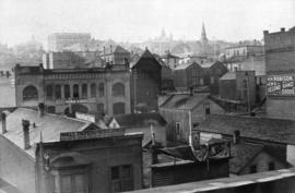
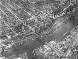
ca. 1894. Business district of Tacoma (copy of original), circa 1894. Many of the streets surrounding Pacific Avenue in the 1890s, even then the heart of the city's financial district, were filled with a hodgepodge of wood framed buildings and more substantial brick structures. At the foreground are the Pioneer Paint Store, sellers of wallpaper, mouldings, paints, and glass and W.H. Robison's, where new and second hand goods could be purchased. The Freeman & Boggs livery stable, near left center, stood near the corner of 13th & Pacific. George A. Boggs, who was City Treasurer before going into private business, had been sent away to the state pen in Walla Walla after auditors found a $109,000 shortage in the city books. Also in the far right background is the steeple of the original St. Leo's Church near So. 11th & "D" St. S7.2, TPL-378 (Researched by Murray Morgan)


Commercial streets--Tacoma--1890-1900; Business districts--Tacoma--1890-1900; Freeman & Boggs Livery (Tacoma); Pioneer Paint Store (Tacoma); W.H. Robison (Tacoma);

G8.1-070

ca. 1960. Aerial view of Tideflats and downtown Tacoma area, including Wright Park and slices of Division Avenue, ca. 1960. Mount Rainier looms in the background, overlooking the industrial area of Tacoma, City (now Thea Foss) Waterway with its boats and log dumps, and the 11th St. Bridge. Familiar buildings such as the Puget Sound National Bank, Rust, and Washington buildings can be spotted on Pacific Avenue. The County-City Building with its two wings and the State Armory are in mid-photo. The wooded area is Wright Park with its meandering paths clearly marked. Adjoining the park at 9th & Division is the Greek Ionic styled First Church of Christ, Scientist. TPL-9664


Aerial photographs; Neighborhoods--Tacoma; Wright Park (Tacoma); Rainier, Mount (Wash.);

Results 181 to 210 of 824