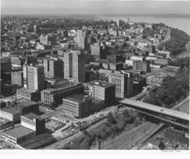
Showing 824 results

Collections
Aerial Photography Image With digital objects
Print preview View:

D61250-2

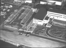
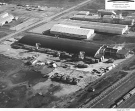
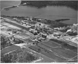
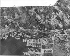
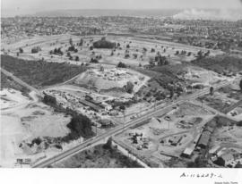
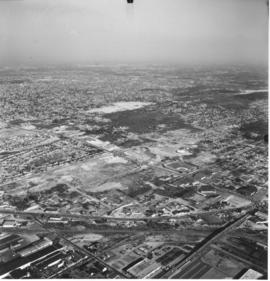
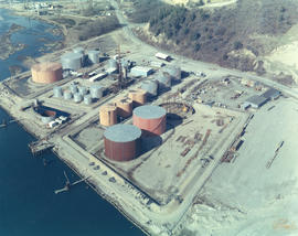
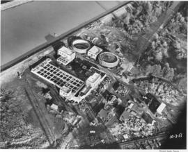
Aerial photograph of sewage disposal plant. Progress was being made in the construction of a new waste disposal facility on Cleveland Way near the Puyallup River in October, 1951. Aerial view of plant; large circular structures are digesting tanks, square building between them the digestion control building. Raw sludge would be processed in the digesting tanks where ultimately it would be filtered, peeled off in cakes, and then hauled away for fertilizer. According to a 12/12/51 article in the News Tribune, the plant was designed to handle 27 million gallons of sewage a day. Photograph commissioned by Hoagland-Findlay. TPL-8825


Aerial photographs; Progress photographs; Building construction--Tacoma--1950-1960; Sewerage--Tacoma; Waste disposal facilities--Tacoma; Hoagland-Findlay Engineering Co. (Seattle);

A66035-40

Aerial view of 1952 Daffodil Parade as it proceeds down Pacific Avenue. The day of the parade dawned clear and sunny, prompting 200,000 Tacomans to line the parade route. People stood 10 deep at prime viewing spots, with others watching from windows, awnings, hanging from fire escapes and perching on roofs.


Celebrations--Tacoma; Festivals--Tacoma; Parades & Processions--Tacoma--1950-1960; Puyallup Valley Daffodil Festival (1952 : Tacoma); Drill teams; Marching bands; Floats (parades)--Tacoma--1950-1960; Aerial photographs;

A58908-1

This aerial view of the St. Paul & Tacoma Lumber Company shows Mount Rainier in the background. Included in the photograph are the sawmill, lumber storage and shipping sheds, planing mill, dry kilns, and the barking and chipping plant. The log storage and sorting ponds, railroad log dumps, deep water shipping dock and shed are not shown, as the plant covers an area of 180 acres, about 1/4 mile wide and a mile long. The company sprawled along the St. Paul Waterway, to the left of this photograph, between St. Paul and Portland Avenues. The Puyallup River can be seen heading east with several bridges crossing it. Ordered by St. Paul & Tacoma Lumber Company. (Tree Life Hemlock, St. Paul & Tacoma Lumber Co.)


Aerial photographs; St. Paul & Tacoma Lumber Co. (Tacoma); Cityscapes; Lumber industry--Tacoma--1950-1960;

A62426-2

Aerial photographs were taken of Jefferson Avenue in November, 1951. Building on the right hand corner belongs to Blake, Moffitt & Towne, wholesale distributors of printing and wrapping paper. Rectangular two-story buildings in center of photograph are probably structure known as "Jefferson House", built originally in 1945 to provide emergency accomodations for single men. Jefferson Avenue was primarily a business district, filled with apartment buildings and manufacturers. Photograph ordered by John Huston.


Aerial photographs; Cityscapes; Commercial streets--Tacoma--1950-1960;

A63231-1

Aerial photograph to show the steel work on a new building at St. Regis, Tacoma. Construction of a bag plant at the St. Regis Paper company started in June 1951 with the driving of piling as the first step. The addition was built of steel and concrete and would be used for the production of industrial-use bags for cement, fertilizer and other materials needing heavy-duty holders. When completed, this plant would replace the leased plant at Seattle. (TNT 6/15/1951; St. Regis Paper Company 1951 Annual Report)


St. Regis Paper Co. (Tacoma)--1950-1960; Progress photographs; Building construction--Tacoma--1940-1950; Aerial photographs; Paper industry--Tacoma--1950-1960;

D58919-1

An aerial photograph of the Northgate shopping area. The building in the center of this June, 1951, photograph contains Larson's Department Store and Ridgecrest Super Market. Ordered by Phares Advertising. The area is mixed use with single-family residential areas near this commercial area.


Aerial photographs; Shopping centers--Seattle; Land use--Seattle--1950-1960; Real estate development--Seattle--1950-1960;

A113921-8

Another view of the bridges crossing the Puyallup River was taken via air by Richards Studio on April 22, 1958. Water levels indicate that the river had not overflooded its borders. There are no buildings directly on the river's edge because of the flooding potential. The white or light gray colored bridge has been identified as the Eells St. bridge looking south. From above it appears to have an open geometric design; the curvature on top is reminiscent of a roller coaster track. It connected Pacific Highway and Fife to the left and Puyallup Ave. and Tacoma to the right. The other two bridges were railroad bridges and still there some fifty years later. (Additional identification provided by a reader)


Aerial photographs; Bridges--Tacoma--1950-1960; Railroad bridges--Tacoma; Eells St. State Highway Bridge (Tacoma); Puyallup River (Wash.);

A113586-1

Woodlam, Inc., was a laminated wood products company located in the Tideflats at 1476 Thorne Rd. William Lindberg was listed as president in the 1959 City Directory. Woodlam was formerly known as Laminated Wood Products Co. and was owned by Arne Strom. Strom had opened the plant in February, 1957, and sold the facility to Lindberg in April, 1958. Woodlam, Inc., employed between 80-100 workers. Purchase of the plant involved eight acres of land, a 500 X 100 foot main plant, drying kilns and a suite of offices. Aerial photographs were taken on April 10, 1958, showing piles of plywood outside the large plant facilities. Railroad tracks close by meant easy rail access for the laminated products. Photograph ordered by Woodlam, Inc. (TNT 4-26-58, A-1)


Aerial photographs; Woodlam, Inc. (Tacoma);

A104350-6

Construction at Fort Lewis remained strong in the mid-1950's as the military population continued to grow. February 12, 1957, aerial photographs show two company barracks and utilities structures being built at the south end of Gray Field. Donald M. Drake Co. of Portland, Oregon, apparently were involved in Contract #3706. Photograph ordered by the Donald M. Drake Co.


Aerial photographs; Building construction--Fort Lewis; Donald M. Drake Co. (Portland, Or.);

A74601-4

ca. 1953. Aerial photographs, St. Regis Paper Co. St. Regis had plants in several states, as well as in Canada and South America. This aerial view of the St. Regis plant in Jacksonville, Florida, was taken in 1953. As was the case in most of the company's plants, there was plenty of room for future expansion and water transportation was readily available.


Aerial photographs; St. Regis Paper Co. (Jacksonville, Fl.)--1950-1960; Paper industry--Jacksonville--1950-1960; Industrial facilities--Jacksonville--1950-1960;

D75453-3

This was how Marymount Military Academy appeared from the air on July 28, 1953. The Academy was the only military school in Washington State. Located in what would now be Spanaway, the school was run by the Dominican Sisters, a Catholic teaching order. Young boys aged 6-16 were accepted for enrollment at this boarding school. Ground was broken at the site in July of 1922 and the school was dedicated in May of 1923. Built at a cost of $200,000 on the former "Shangarry" estate of J. Shields, Marymount originally was built in the Lombardine Mission style with modern gym, pool and infirmary. Enrollment was capped at 150 students; however, lessening enrollment and higher operating costs forced closure of the school in 1976. The property was purchased in the 1980's by Harold LeMay, who used much of it to house his antique car collection. TPL-9701


Aerial photographs; Marymount Military Academy (Spanaway); Private schools--Spanaway; Military education--Spanaway;

D75943-6

This aerial view of the Tacoma tideflats and Port of Tacoma was taken in July of 1953. At the upper right of center a small fleet of baby flat tops built in Tacoma during World War II are "mothballed" in the Wapato (now Blair) Waterway next to the Tacoma naval station. The Port of Tacoma is to the left of the mothballed ships. Browns Point can be seen in the upper right corner. Commencement Bay can be seen lying beyond the Port. The two streets crossing the tideftats are East Eleventh Street and Lincoln Avenue (in the bottom half of the image). TPL-2259.


Aerial views; Port of Tacoma (Tacoma)--1950-1960;

D75943-8

Aerial view of the Tacoma tideflats and Port of Tacoma. TPL-2254. The intersection of Lincoln Ave. (right), Alexander and E. 11th Street (left). Port of Tacoma and Port Industrial Waterway visible. Photograph shows the 1500 acres of vacant land that the city of Tacoma hoped to sell to industries needing a deep water port.


Aerial views; Port of Tacoma (Tacoma)--1950-1960;

D77321-8

Aerial of downtown Tacoma looking west from the intersection of Eleventh and A streets.


Aerial photographs--1950-1960; Business districts--Tacoma--1950-1960;

C84642-1

Copy of customer's print. The Port of Tacoma Industrial area is seen in an aerial view in a photograph copied for Howard R. Smith. Mr. Smith, a well-known Tacoma businessman, had been president of the Tacoma Athletic Commission and involved in advertising for many years. The photograph was copied on August 27, 1954; actual date of print is unknown. Log dumps for various lumber concerns are clearly visible to the picture's right.


Aerial photographs; Port of Tacoma (Tacoma);

C87936-B

Aerial view of the Port of Tacoma, for Cheney Lumber Co. Port Piers, Naval Station (with mothballed fleet) and Hylebos Waterway can be clearly seen. Photo continues around Browns Point and on to Dash Point. Roads appear as clear white lines. TPL-2262


Aerial photographs; Bays--Washington (State); Commencement Bay (Wash.); Port of Tacoma (Tacoma)--1950-1960;

C87936-A

Aerial view of the Port of Tacoma, for Cheney Lumber Co. The Port Piers and the Naval Station, with mothballed fleet, can be seen. There were 25 mothballed escort carriers under the care of the Tacoma Group, Pacific Reserve Fleet. The ships were serviced and kept in readiness for war. The Hylebos Waterway can be clearly see all the way to the turning basin. The roads appear as clear white lines. TPL-2261


Aerial photographs; Bays--Washington (State); Commencement Bay (Wash.); Port of Tacoma (Tacoma)--1950-1960;

A116229-2

Aerial photographs taken on August 14, 1958, of the Center & Pine area paint an almost surrealistic view of the surroundings. The Lundberg Concrete Pipe Co. is the cluster of buildings located near the center of the picture. As their name indicates, they were pipe manufacturers. Located on top of a neighboring hillside is the storage area for the pipes. Beyond Lundberg Concrete appears to be the Allenmore Golf Course. Photograph ordered by Lundberg Concrete Pipe Co., Inc.


Aerial photographs; Lundberg Concrete Pipe Co., Inc. (Tacoma); Pipes (Conduits)--Tacoma; Industrial facilities--Tacoma;

A116910-6

The enormous Grandstand at the Western Washington Fair had been expanded since its construction circa 1908. W.H. Paulhamus served as president of the fair from 1906 to 1925; he acted as announcer and master of ceremonies for the grandstand acts. Hawaiian musicians, Arabian tumbling acts, and parades of livestock entertained viewers in the fair's early days. Later, horse racing became one of the most popular of all attractions on the fairgrounds. View of 1958 Western Washington Fair: Grandstand, exhibition halls, restaurants, and packed parking lots. Emmett Kelly, the world-famous, sad-faced clown, would be making his first West Coast appearance in eight years in twice-daily grandstand shows. For a $1.50, ticketholders could see Kelly, watch the three Zacchinis shot from cannons, admire the Dancing Dalmations, and cheer on three horse races and the cattle parades. Photograph ordered by Puyallup Fair Association. (Souvenir Booklet 50th Western Washington Fair, 1953, TNT 8-20-58, ad) TPL-9295


Aerial photographs; Western Washington Fair (Puyallup); Grandstands--Puyallup;

A120358-63

ca. 1959. Aerial of Tacoma, looking across downtown to the Tideflats, circa 1959. The City Waterway (now Foss) bisects the picture, crossed by its three bridges. A haze rises from the heavily industrial Tideflats.


Aerial photographs--1950-1960; Cityscapes--1950-1960; City Waterway (Tacoma);

A115129-1A

Aerial photographs of the downtown Tacoma area, including the business and financial district, were taken by the Richards Studio on June 16, 1958. This photograph was noted as being "cropped." It shows the 11th St. Bridge as it prepares to cross the City (now Thea Foss) Waterway. Pacific Avenue and A Streets, Saint Helens and Market, Broadway and Commerce are all visible. An observer can identify the Crane Co., the National Bank of Washington, Puget Sound National Bank, the Washington Building with the Mobilgas sign, the Rust Building, Old City Hall with its memorable clock tower, and the skyscraper, the Medical Arts Building. Shuster Parkway will later be built in the thin strip of wooded area adjacent to and under the bridge. TPL-8186


Aerial photographs; Commercial streets--Tacoma--1950-1960; 11th Street Bridge (Tacoma);

A116017-2

Mount Rainier was shrouded in clouds on August 8, 1958, when aerial photographs of the future Tacoma Mall area were taken for Allied Owners, Inc. A series of photographs were taken between South 38th & South 56th Streets from Sprague to Pine. The baseball field toward the center of the picture is probably Cheney Field which was on 38th & Lawrence. It is possible that the Tacoma Mall would be in or near the wooded area toward the top of the photograph. This south end area would be further changed with the coming of the freeway in a few years.


Aerial photographs; Aerial views; Neighborhoods--Tacoma--1950-1960;

A116230-1

Aerial photographs taken on an overcast August 14, 1958, show the bustling downtown area and beginnings of the Tideflats. The 11th and 15th St. bridges cross the City (now Thea Foss) Waterway leading to the city's industrial area. The new County-City Building and soon-to-be demolished Courthouse are clearly evident toward the center of the picture. Wright Park is the wooded area nearby. Schoenfelds enormous lettering always captures the camera's eye as it wanders along Pacific Avenue, with Puget Sound National Bank and the Washington Building further up the road. Shuster Parkway is not yet built but its pathway can be imagined near the wooded area close to the 11th St. bridge. The area around 24th & Pacific, including Jefferson, and other portions of downtown Tacoma, were scheduled for an urban renewal project in the late '50's. That area is near the lower left corner by the Union Station. This downtown area would be the home of the future University of Washington-Tacoma campus. TPL-8158


Aerial photographs; Commercial streets--Tacoma--1950-1960;

A116229-1

Lundberg Concrete Pipe Co., Inc., occupied a large stretch of land on Center Street near Pine. Aerial photographs taken on August 14, 1958, show a modern industrial plant surrounded by sections of pipe. Lundberg Concrete also apparently used nearby hillside site for storing large pipes. The company was a family-owned business, headed by Oscar N. Lundberg as president. Allenmore Golf Course appears to be located on the photo's left side. Photograph ordered by Lundberg Concrete Pipe Co., Inc.


Aerial photographs; Lundberg Concrete Pipe Co., Inc. (Tacoma); Pipes (Conduits)--Tacoma; Industrial facilities--Tacoma--1950-1960;

D155600-450C

ca. 1969. 1969 Richards stock footage. Aerial view of Eastern Oil operations in 1969. Storage tanks dot the landscape of the large site on Marine View Dr. N.E. facing the Hylebos Waterway. Although tentatively identified as "Eastern Oil," it is possible that this is actually the Sound Refining Co., located on the northwest edge of the Tideflats. Sound Refining began operations in 1967 as a crude oil refinery.


Aerial views; Eastern Oil Co. (Tacoma); Storage tanks--Tacoma;

D155048-7

Series of aerial photographs of So. 19th & Mason neighborhoods. This view on November 8, 1968, is captured looking toward the north end neighborhoods and beyond them, eastward to the industrial Tideflats where dense smoke can be seen from many stacks. The ballpark on the right center is Heidelberg Field. Bare land across So. 19th St. from the athletic field will eventually become a shopping center. So. 19th will make its curving way to intersect with Hwy 16. A new road is being cut through woods west of the ballpark. The City of Fircrest is at lower portion of photograph. Photograph ordered by Morley Studios. TPL-3801


Aerial views; Neighborhoods--Tacoma--1960-1970; Heidelberg Field (Tacoma);

D155600-143

1969 Richards stock footage. Aerial 1969 views of neighborhoods around Sixth Ave. and No. 11th St. Sixth Ave. is street towards the top of the July 1, 1969, photograph; Towers Restaurant is large building near the right edge. Hunt Junior High (now Middle School) is on So. 10th with its mushroom-shaped cafeteria clearly visible. No. 11th is the street directly below the large expanse of woods; when it intersects Skyline, it turns into Bridgeview. Streets above Skyline are (top to bottom) Hawthorne, Rose and Lenore. Woods between Sixth Ave. and No. 11th have since been developed.


Aerial views; Neighborhoods--Tacoma--1960-1970; Henry F. Hunt Junior High School (Tacoma); Towers Restaurant (Tacoma);

D155750-5

Closer look by air on April 29, 1969, of the 40th & Bridgeport Way area in University Place. 40th is the prominent road running vertically near the right side of the photograph; it is intersected by Bridgeport Way. University Place water tower is at very bottom to the left of 40th; University Village Shopping Center with large parking lot is on the right. Photograph ordered by Puget Sound National Bank.


Aerial views; Neighborhoods--University Place; Shopping centers--University Place;

D155600-352C

1969 Richards stock footage. View by air of new Pier 4 at the Port of Tacoma on July 1, 1969. The destroyer USS Parsons (DDG-33) is docked at pier. Long stream of people almost the length of the dock appear to be waiting to perhaps take a tour of the ship. The USS Parsons along with the battleship USS New Jersey visited Tacoma during the city's Centennial celebrations the end of June, 1969. The Parsons was a guided missile destroyer used as an anti-submarine and anti-aircraft vessel. She had sustained a minor accident while easing into Pier 4 on June 30th, smashing the pier's gangway and float. (TNT 7-1-69, p. 2)


Aerial views; Piers & wharves--Tacoma--1960-1970; Government vessels--Tacoma; Warships--Tacoma--1960-1970;

D156904-4

Aerial views of the City of Olympia requested by Puget Sound National Bank. Olympia, the state capital, is located at the head of Budd Inlet in the northern part of Thurston County. It was officially platted in 1850 by settler Edmund Sylvester who laid out a town in the New England style with town square, tree lined streets, Masonic Hall, land for schools and capitol grounds. The grand domed Legislative Building overlooking Capitol Lake was completed in 1927. It was damaged in the April, 1949, earthquake and later in the 1965 earthquake but was repaired and reinforced. The bridge to the right of the capitol buildings was heavily damaged in the earthquake of 2001. (www.ci.olympia.wa.us/information/history)


Aerial views; Legislative Building (Olympia); Streets--Olympia--1960-1970; Capitol Lake (Olympia);

Results 61 to 90 of 824