Showing 824 results

Collections
Aerial Photography Image With digital objects
Advanced search options
Print preview View:

D142699-16

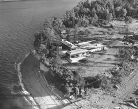
Located on a hillside at the edge of Ketron Island in September, 1964, was a large structure, either a luxurious residence or hotel. This aerial view shows how close it was built to the water with small beach below. Two rowboats and driftwood are located near a wooden bridge extending into the water.


Aerial photographs; Rowboats--Ketron Island; Buildings--Ketron Island; Beaches--Ketron Island;

D142647-1

This aerial view of St. Regis Paper Company's chip operations was taken in mid-September of 1964. A barge marked "Vancouver Tug" unloads tons of pulp-mill chips at the Tacoma kraft mill of St. Regis Paper. Two large mountains of chips are in storage outside side-by-side. Photograph ordered by Malcolm McGhie, industrial consultant, New York.


Aerial photographs; St. Regis Paper Co. (Tacoma)--1960-1970; Paper industry--Tacoma--1960-1970; Barges--Canada--Vancouver;

D145092-4

View by air of the new Tacoma Elks Temple being constructed in the 1900 block of So. Union Ave. in June of 1965. The building was designed by the architectural firm of E.L. Mills & Associates and built by Strom Construction Co. using reinforced concrete and structural steel. Tacoma Lodge No. 174, one of the largest Elks Club memberships in the world, had voted to build a new temple away from its 50-year location on Broadway. The 1.5 million dollar (later cost revised to 2 million dollars) temple would be dedicated on September 3, 1965, amidst celebrating the lodge's upcoming 75th anniversary.


Aerial photographs; Benevolent and Protective Order of Elks, Tacoma Lodge No. 174 (Tacoma); Building construction--Tacoma--1960-1970;

D147400-24

1966 Richards stock footage. Mount Rainier, with Mount Adams in the background to the right, looms over the Lake Tapps/South Auburn general area in 1966. The aerial view is northwest to southeast, taken from about the I-5/Highway 18 intersection. Lake Tapps is large body of water in mid-photo. Nearby is the White/Stuck River at the foot of the hills lined with trees. The southern portion of the city of Auburn is on the left side of the photograph. The large complex of warehouse-styled buildings in the foreground is a Boeing plant.


Aerial photographs; Lake Tapps (Wash.); Rainier, Mount (Wash.);

D147400-15

1966 Richards stock footage. Northbound look by air of the Tacoma Tideflats industrial area, home to St. Regis Paper Co. and many others, on April 5, 1966. Heavy smoke identifies the location of St. Regis towards the left side of photo, next to the Puyallup Waterway. Among various nearby waterways is the Port Industrial Waterway (center) which was being extended. Interstate 5 is freeway running left to right near the bottom of the photograph. At the end of 1965 the freeway ran from the Oregon border through Tacoma to Midway.


Aerial photographs; St. Regis Paper Co. (Tacoma)--1960-1970; Smoke--Tacoma; Port Industrial Waterway (Tacoma); Express highways--Tacoma--1960-1970;

D147400-17

Richards Studios stock footage, 1966. Looking south via air, smoke from St. Regis Paper Co.'s plant and low clouds obscure the Tacoma Tideflats landscape on April 5, 1966. A small section of the Puyallup River can be spotted on the extreme right; various waterways emerging into Commencement Bay include the Hylebos on the extreme left, Port Industrial and Sitcum.


Aerial photographs; St. Regis Paper Co. (Tacoma)--1960-1970; Smoke--Tacoma; Puyallup River (Wash.); Hylebos Waterway (Tacoma); Port Industrial Waterway (Tacoma); Sitcum Waterway (Tacoma);

D148299-1

The National Bank of Washington opened its $800,000 electronic center in April, 1965, at 1015 Center St. Tacoma architects Lea, Pearson & Richards designed the building which was built by John Lade, contractor. This aerial view, taken on February 14, 1966, shows the multi-storied building with large electronic sign. Goodwill Industries, visible on nearby So. 27th St., was built and designed by the same people responsible for the electronic center; it also opened in 1965. Tacoma's industrial Tideflats area can be seen indistinctly in the horizon. Photograph ordered by National Bank of Washington.


Aerial photographs; National Bank of Washington (Tacoma); Banks--Tacoma; Goodwill Industries, Inc. (Tacoma);

C148862-3

ca. 1966. This aerial view of Tacoma south of the I-5/ South 38th Street interchange was taken several months after the Tacoma Mall Shopping Center had its grand opening in October 1965. The Mall, with some 70 stores including J.C. Penny, Kress, a Thriftway supermarket and the Bon Marche, offered parking for 7,000 cars. The bright area above and to the left of the 56th Street cloverleaf is Wapato Lake. The housing area at the bottom, to the right, is Lincoln Heights. When this photograph was taken the Mall was an island of commercial property surrounded by residential housing. (Photograph ordered on June 7, 1966, by Bank of California.)


Aerial photographs; Express highways--Tacoma--1960-1970; Tacoma Mall Shopping Center (Tacoma); Shopping centers--Tacoma--1960-1970; Wapato Lake (Tacoma); Neighborhoods--Tacoma--1960-1970;

D149224-8

This aerial photograph taken on July 22, 1966 showed the westward view of the So. 19th & Union Ave. neighborhood. The new Elks Temple, 1965 So. Union Ave., with its enormous parking lot was right of Union. It was next to the new Allenmore Medical Center. The open area next to the Elks would eventually become the site of retail and office buildings. Franklin Park was located at the upper center of the photograph, at approximately So. 12th & Puget Sound. The H-shaped apartment complex at 1902 So. Union was the Unionaire Apartments, built by Lundstrom Building Enterprises. Photograph ordered by Puget Sound National Bank.


Aerial photographs; Neighborhoods--Tacoma--1960-1970; Allenmore Medical Center (Tacoma); Unionaire Apartments (Tacoma); Benevolent and Protective Order of Elks, Tacoma Lodge No. 174 (Tacoma);

D149224-17

Mount Rainier peeks through a blanket of clouds in this July 22, 1966, aerial view of the Tacoma Narrows Bridge and the city's west end including the Titlow Beach area. Mount Adams is almost totally obscured to Rainier's right. I-5 runs along the photo's horizon. Sixth Avenue leads directly onto the Narrows Bridge. Jackson intersects with Sixth just prior to the long bridge entrance. Tacoma Community College in the 5900 block of So. 12th had just finished its first year of existence; the school, located on a 40-acre plot, is about mid-center in the photograph. Photograph ordered by Puget Sound National Bank. TPL-10541


Aerial photographs; Tacoma Narrows Bridge (Tacoma); Bridges--Tacoma--1960-1970; Suspension bridges--Tacoma; Rainier, Mount (Wash.); Tacoma Community College (Tacoma);

A124027-3

Pioneer Sand and Gravel Co.; aerial view of the gravel pit located at Steilacoom, Wa. The company specialized in sand, gravel, concrete and building materials. TPL-9238


Industry--Steilacoom; Sand--Steilacoom; Digging--Steilacoom; Waterfronts; Harbors--Steilacoom; Sandstone quarrying--Steilacoom; Industrial facilities--Steilacoom; Aerial views; Pioneer Sand & Gravel Co. (Steilacoom);

D125600-21

ca. 1960. Richards stock footage. Aerial photograph taken in 1960 of the Hooker Electrochemical Co. plant located at 605 Alexander Avenue on the Tacoma Tideflats. A ship is docked at the company dock on the Hylebos Waterway, ready to transport and transfer Hooker products. A railroad spur running through the facility also made transportation of Hooker chemicals an easier task.


Aerial photographs; Hooker Electrochemical Co. (Tacoma); Chemical industry--Tacoma--1960-1970; Hylebos Waterway (Tacoma); Harbors--Tacoma;

A125600-26

ca. 1960. Aerial photograph of the Pennsylvania Salt Manufacturing Co. in 1960 Richards Studio's stock footage. This Tacoma plant, opened in 1929, covered nearly 40 acres of tideflats on the Hylebos Waterway. A ship is docked ready to transport Pennsalt's chemical products. TPL-6578


Pennsylvania Salt Manufacturing Co. of Washington (Tacoma); Chemical industry--Tacoma--1960-1970; Aerial photographs;

C125600-1

ca. 1960. Customer copy of Tideflats area in 1960. This aerial photograph shows the various waterways and busy industrial scene of the Tideflats. In the foreground is the City (Thea Foss) Waterway. TPL-10130


Aerial photographs; Harbors--Tacoma; City Waterway (Tacoma);

D129800-3

ca. 1961. Scenic views and stock file, 1961. Aerial view heading north toward the water showing site of Yakima Avenue Bridge under construction with Hood St. Reservoir as large body of water to the lower center. Holy Rosary Church is structure with tall steeple near Tacoma Avenue South. Downtown businesses at top center with busy industrial Tideflats across waterways at right.


Aerial photographs; Bridge construction--Tacoma--1960-1970; Bridges--Tacoma--1960-1970; Yakima Avenue Bridge (Tacoma); Holy Rosary Church (Tacoma);

D129737-2

This aerial view of Tacoma, taken from 1,200 feet, shows I-5 and the 38th Street cloverleaf as they appeared in January of 1961. The simple curve of the highway had not yet been complicated by the addition of the Highway 16 interchange. The houses to the left are surrounded on the north and west by I-5 and on the south by 38th Street. The buildings at the bottom, right are on South Tacoma Way.


Aerial photographs; Express highways--Tacoma--1960-1970;

D129800-68

ca. 1961. Aerial photograph of the Meadow Park Golf Course, taken for 1961 stock footage. Located at 7108 Lakewood Drive West, the Meadow Park Golf Course now offers 27 holes of golf on a well developed course lined with fir and oak trees.


Aerial photographs; Meadow Park Golf Course (Lakewood); Golf--Lakewood--1960-1970;

D129800-34

Airborne view of George Barclay's Mayfair Estates, 1961. Local builder George Barclay constructed many homes in his 90-acre Mayfair Estates located in the E. 138th St. area of Parkland. Aerial photograph shows homes would have splendid views of Mount Rainier. Tree stands dot the landscape. One of Barclay's homes at 1312 E. 138th St. was selected as the 1960 Idea Home for Better Homes & Garden magazine.


Aerial photographs; Neighborhoods--Parkland;

D129383-15

Large sections of wooded terrain are interspersed with neatly laid out streets in aerial photographs taken by the Richards Studio on December 15, 1960. Looking northwest, South Tacoma railroad shops are on the left; flat bare land upper center is location of future Tacoma Mall. Photograph taken on behalf of North Pacific Bank.


Aerial photographs; Neighborhoods--Tacoma--1960-1970;

D129800-131

Aerial view from the Narrows of Tacoma's West End with downtown, the Tideflats and Browns Point beyond. Sixth Avenue runs down the right side of the photograph, veering left to form the entranceway for the second Narrows Bridge. Pearl Street crosses Sixth about 2/3 up, with the area allotted for the Tacoma airport still undeveloped. The area between where Sixth leads to the bridge and Titlow Beach (off the photo at right) is mostly undeveloped. The smokestack for the ASARCO plant can be seen on the far left, surrounded by the city of Ruston. For an older view of this same area (ca. 1939), see D8245 image 1. TPL-9158


Aerial photographs; Neighborhoods--Tacoma--1960-1970; Streets--Tacoma--1960-1970; Tacoma Narrows Bridge (Tacoma); Bridges--Tacoma--1960-1970; Suspension bridges--Tacoma;

D129800-43

Aerial view from Commencement Bay of Tacoma's West End with downtown and the Tideflats beyond. Running down the center of the photograph is Sixth Ave, which veers left to serve as the entrance for the second Narrows bridge. The portion that veers to the right travels to Titlow Park. In the lower right hand corner the Park's swimming pool and the natural salt water lagoon can be seen. The area around the Narrows is still largely undeveloped. Crossing Sixth Ave. at about the center of the picture is Pearl Street. The Tacoma Auto View Theater is at 1202 North Pearl. To the left of the Auto View and below, an abandoned excavation looks like pattern against the ground. For an older view of this same area (ca. 1939), see D8245 image 1. TPL-9157


Aerial photographs; Neighborhoods--Tacoma--1960-1970; Streets--Tacoma--1960-1970; Titlow Park (Tacoma);

D129800-80

ca. 1961. Stock footage and scenic views, 1961. Port of Tacoma industrial landscape with Mount Rainier in background. Hylebos bridge extending over the Hylebos; 11th St. extends over the Port Industrial, Sitcum, Milwaukee and Puyallup Waterways. Log dumps near and in the Sitcum Waterway, probably for use by Tacoma Boatbuilding. TPL-10517


Aerial photographs; Port of Tacoma (Tacoma); Rainier, Mount (Wash.);

D129800-75

ca. 1961. Tacoma-side view of the second Narrows Bridge; stock aerial footage, 1961. Mount Rainier rises majestically in the background overlooking the Narrows Bridge. Henry F. Hunt Junior High (now Middle School) with its unique mushroom-shaped cafeteria lies off the Sixth Avenue approach to the bridge on So. 10th St. Permission was granted to the Washington Pilots Assn. to reproduce this photograph in conjunction with its 1963 convention.


Aerial photographs; Tacoma Narrows Bridge (Tacoma); Suspension bridges--Tacoma; Henry F. Hunt Junior High School (Tacoma);

A129800-113

ca. 1961. Scenic view and stock footage, 1961. Aerial view of busy Port of Tacoma in 1961on Sitcum and Port Industrial Waterways; building in the center is the port's own grain elevators along with loading dock and storage buildings. The two buildings above the granary are terminals and warehouse #1 belonging to the Chicago, Milwaukee, St. Paul & Pacific RR. Ships are docked waiting to load plywood and other lumber products. Log dumps located nearby.


Aerial photographs; Port of Tacoma (Tacoma);

D130081-2

Tacoma's landscape in the 1960's would slowly be changing as nearly all of the vacant land and woods near the Sixth Avenue and Orchard area would be occupied by new homes and businesses. The tip of Cheney Stadium can be seen in the upper right hand corner. Busch's Drive-In is the long building with dark roof towards the center of the photograph; the bare area next door would become part of Kmart in the future. Boulevard Texaco service station is next to Busch's at the intersection of Sixth & Orchard. Across Sixth Avenue from Busch's is the relocated First Christian Church which was dedicated on February 19, 1961. The church had originally been located in downtown Tacoma since 1906; a new building was constructed at 6th & Orchard for $400,000. The large rectangular building with dark roof near the bottom right of the picture is believed to be Stebner's Inc, located at 5510 Sixth Ave. Stebner's was located two blocks west of Busch's and had celebrated its grand opening at that location on November 17, 1960. Photograph ordered by Busch's Sixth Avenue Drive-In.


Aerial photographs; Neighborhoods--Tacoma--1960-1970; Busch's Sixth Avenue Drive-In Restaurant (Tacoma); Boulevard Texaco (Tacoma); First Christian Church (Tacoma); Stebner's, Inc. (Tacoma);

D133276-3

ca. 1961. Additional close-up view of D133276-1, Tacoma Tideflats industrial area, ca. late 1961, looking toward Mount Rainier and Puyallup. Waterway to the left is the Hylebos; large building near it is the Western Farmers Assn. feed mill. Notable streets are Taylor and Lincoln. TPL-4740


Aerial photographs; Industrial facilities--Tacoma--1960-1970;

D133276-2

ca. 1961. Aerial views taken in late 1961 of major manufacturers in the Tacoma Tideflats industrial area. Large building with loaf-shaped roof at left is Educators Mfg. Co., makers of school furniture, which had opened a new million dollar plant on Lincoln Avenue in 1958. Across the street are Reichhold Chemicals and Pennsalt. Hylebos Waterway is located next to the Western Farmers Assn. feed mill. Gravel pit and Browns Point area beyond the Hylebos.


Aerial photographs; Industrial facilities--Tacoma--1960-1970; Educators Manufacturing Co. (Tacoma);

D133276-4

ca. 1961. Aerial views of Tacoma industrial area in late 1961. Large building in center with dark roof is the Educators Mfg. Co., exclusive makers of classroom cabinets, located on Lincoln Ave. The Educators Mfg. plant was built in 1958 on ten acres in the Tideflats. Western Farmers Assn. (formerly Washington Cooperative Egg & Poultry Association) feed mill on left, along the Hylebos Waterway. Gravel pit in background across the Hylebos.


Aerial photographs; Industrial facilities--Tacoma--1960-1970; Educators Manufacturing Co. (Tacoma);

D133276-10

Closer look at Tideflat businesses via plane on January 9, 1962, for use in sample book. Educators Manufacturing Co. is on the left corner with dark roof, Western Farmers Assn. feed mill with large sign upper left. This is the busy intersection of Lincoln and Taylor Avenues. Hylebos Waterway in background next to gravel pit. A glimpse of Browns Point can be spotted beyond trees.


Aerial photographs; Industrial facilities--Tacoma--1960-1970; Hylebos Waterway (Tacoma);

D137300-113

ca. 1963. Overview of downtown Tacoma area looking east including City Waterway, industrial areas, taken by air in 1963. Central School, the County-City Building, and Tacoma Public Library's Main branch and Carnegie Building are shown from the rear in photo's center. Washington State Armory with black roof and Tacoma Vocational-Technical School (Bates) with radio tower across the street on 11th & Yakima. Parts of the Tideflats on various waterways can be seen including busy St. Regis Paper Co.


Aerial photographs; Commercial streets--Tacoma--1960-1970; County-City Building (Tacoma); Tacoma Public Library (Tacoma); Central School (Tacoma); State Armory (Tacoma); Tacoma Vocational School (Tacoma);

Results 91 to 120 of 824